Maggie Valley Steve
-
Posts
449 -
Joined
-
Last visited
Content Type
Profiles
Blogs
Forums
American Weather
Media Demo
Store
Gallery
Everything posted by Maggie Valley Steve
-

2024-2025 Fall/Winter Mountain Thread
Maggie Valley Steve replied to Buckethead's topic in Southeastern States
Back to mostly moderate to at times heavy snow mixed with some sleet. The wind is very brisk out there now. -
2024-2025 Fall/Winter Mountain Thread
Maggie Valley Steve replied to Buckethead's topic in Southeastern States
Yeah, as soon as the wind started howling down the Valley, sleet let up. The driveway caved badly even with salt down. -
2024-2025 Fall/Winter Mountain Thread
Maggie Valley Steve replied to Buckethead's topic in Southeastern States
Back to all snow after a heavy sleet shower. Winds are picking up and the temperature has dropped back to 30°. -
2024-2025 Fall/Winter Mountain Thread
Maggie Valley Steve replied to Buckethead's topic in Southeastern States
New Mesoscale Discussion....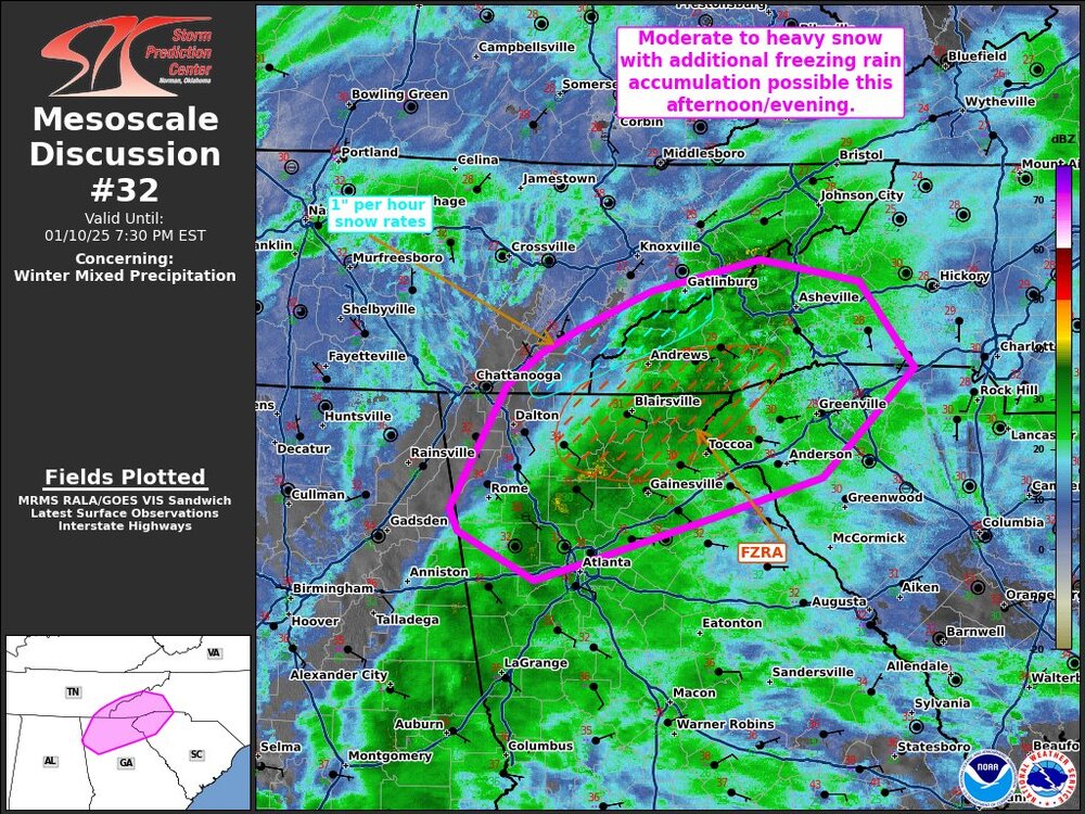
-
2024-2025 Fall/Winter Mountain Thread
Maggie Valley Steve replied to Buckethead's topic in Southeastern States
Just got in from riding all over Maggie Valley, up toward Soco Gap and Cataloochee. Met1985 and I got to experience everything the past couple of hours to rain/snow, sleet/snow and now huge flakes near silver dollars. Back at the house and I have heavy snow with less than a quarter mile visibility! -
2024-2025 Fall/Winter Mountain Thread
Maggie Valley Steve replied to Buckethead's topic in Southeastern States
Temperature here is up to 34. Just very tiny flakes, but radar indicates we'll fill back in shortly. -
2024-2025 Fall/Winter Mountain Thread
Maggie Valley Steve replied to Buckethead's topic in Southeastern States
I got salt down on the driveway 45 minutes ago. Now moderate nickels and quarters falling. Visibility down less than a mile.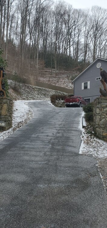
-
2024-2025 Fall/Winter Mountain Thread
Maggie Valley Steve replied to Buckethead's topic in Southeastern States
Ceiling has lowered significantly, light to moderate snow at Cataloochee. Flurries just began at the house. -
2024-2025 Fall/Winter Mountain Thread
Maggie Valley Steve replied to Buckethead's topic in Southeastern States
Up to 27 now. Definitely virga overhead and the ceiling is lowering. It appears that light snow is beginning to fall at higher elevations of the Balsams. It shouldn't be long here before light snow begins. -
2024-2025 Fall/Winter Mountain Thread
Maggie Valley Steve replied to Buckethead's topic in Southeastern States
Reports than snow has started at DT Chattanooga. -
2024-2025 Fall/Winter Mountain Thread
Maggie Valley Steve replied to Buckethead's topic in Southeastern States
Waking up to 26. GSP increased my point and click forecast by an inch or two with no suggested mixing issues. -
1/10-11 super awesome winter SE OBS thread
Maggie Valley Steve replied to strongwxnc's topic in Southeastern States
19° currently with 1 inch of snow on the ground from last Sunday night. -
2024-2025 Fall/Winter Mountain Thread
Maggie Valley Steve replied to Buckethead's topic in Southeastern States
Where's Buckethead? -
2024-2025 Fall/Winter Mountain Thread
Maggie Valley Steve replied to Buckethead's topic in Southeastern States
Down to 21 after a high of 28 here. I still have an inch of snow on the ground from Sunday night/Monday morning. NW Gulf low is cranking up. Time to watch the radar folks. -
2024-2025 Fall/Winter Mountain Thread
Maggie Valley Steve replied to Buckethead's topic in Southeastern States
Man, that would likely bring some 10+ amounts in the jackpot zone! Good luck gang! It's been fun tracking the past couple of weeks and if the medium/long range guidance is correct, we'll be doing it again shortly! -
Refresh your browser. They've updated.
-
2024-2025 Fall/Winter Mountain Thread
Maggie Valley Steve replied to Buckethead's topic in Southeastern States
If I was 15 years younger, I'd be right there with you! Good to see you back WxKnurd! -
2024-2025 Fall/Winter Mountain Thread
Maggie Valley Steve replied to Buckethead's topic in Southeastern States
Starting the day with 11° and clear. -
2024-2025 Fall/Winter Mountain Thread
Maggie Valley Steve replied to Buckethead's topic in Southeastern States
Clouds have rolled back in over Maggie with a cold wind blowing. It feels like snow tonight! -
2024-2025 Fall/Winter Mountain Thread
Maggie Valley Steve replied to Buckethead's topic in Southeastern States
Yeah, radar upstream looks a little juiced up. Another shot of Arctic heading in. -
2024-2025 Fall/Winter Mountain Thread
Maggie Valley Steve replied to Buckethead's topic in Southeastern States
It's going to stay cold behind the storm. No real January 'thaw' showing up either.
-
2024-2025 Fall/Winter Mountain Thread
Maggie Valley Steve replied to Buckethead's topic in Southeastern States
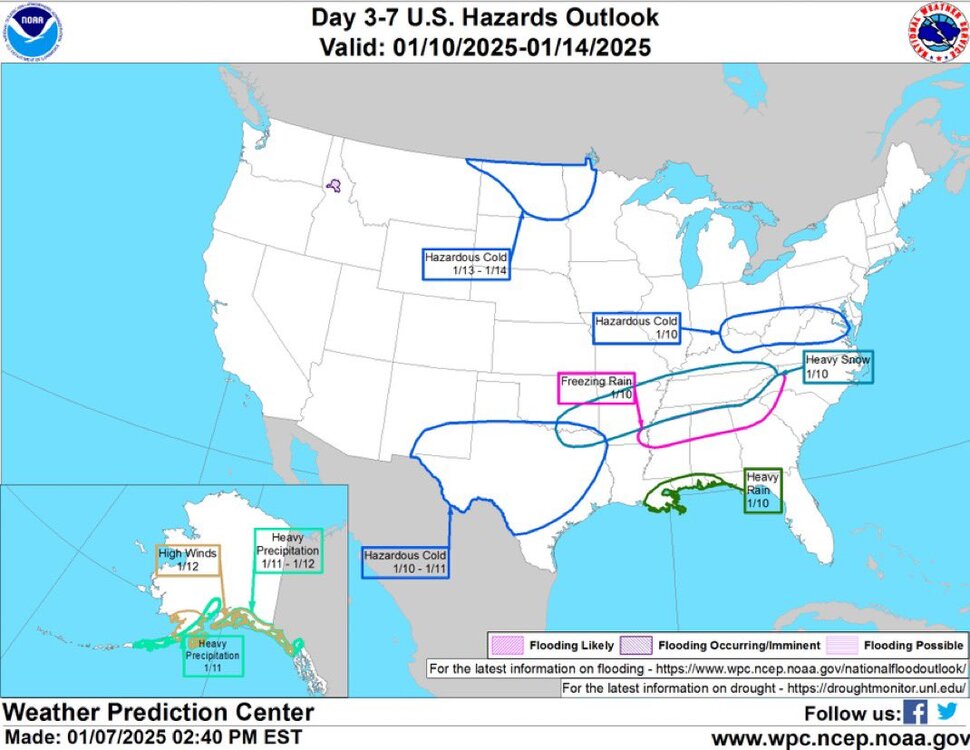
It's too soon for Warnigs in the Mountains. Typically the NWS offices wait until 24 hours before onset. Look for Warnings tomorrow morning. Now Watches likely will be coming in their afternoon packages. -
2024-2025 Fall/Winter Mountain Thread
Maggie Valley Steve replied to Buckethead's topic in Southeastern States
I agree. I understand the frustration very well. Thankfully we had the opportunity to buy a home in the mountains with a little elevation above the Valley floor, yet still easily accessible. The NAM suggested 6 inches for my yard. Certainly would make the biggest event since 2022. -
2024-2025 Fall/Winter Mountain Thread
Maggie Valley Steve replied to Buckethead's topic in Southeastern States
20° for my low this morning. Temperature held steady overnight due to the clouds. Lots rime ice above 3500ft. GSP along with surrounding other WFO's covered the Watches well and early. -
2024-2025 Fall/Winter Mountain Thread
Maggie Valley Steve replied to Buckethead's topic in Southeastern States
Afternoon update...