
Maggie Valley Steve
-
Posts
449 -
Joined
-
Last visited
Content Type
Profiles
Blogs
Forums
American Weather
Media Demo
Store
Gallery
Everything posted by Maggie Valley Steve
-

2024-2025 Fall/Winter Mountain Thread
Maggie Valley Steve replied to Buckethead's topic in Southeastern States
I suspect if the 00Z and 6Z short range guidance increases the amount of deformation banding and heavier as well as a bit longer duration upslope episode, we'll see Winter Storm Watches hoisted for the Mountain Counties tomorrow morning. Now if those thunderstorms along the Gulf Coast end up not coming to fruition as the guidance suggests, we could see higher totals Wednesday with over running snow. We will see. -
2024-2025 Fall/Winter Mountain Thread
Maggie Valley Steve replied to Buckethead's topic in Southeastern States
I believe a general 2 to 4 inches is possible even here in the higher Valleys. To me, the big question is the following upslope snow development as the surface low pressure passes by and the potent upper low slides in Wednesday night into Thursday. -
2024-2025 Fall/Winter Mountain Thread
Maggie Valley Steve replied to Buckethead's topic in Southeastern States
21 here. Clear sky and no snow. -
2024-2025 Fall/Winter Mountain Thread
Maggie Valley Steve replied to Buckethead's topic in Southeastern States
It's been spitting snow off and on most of the afternoon. No accumulation though. -
2024-2025 Fall/Winter Mountain Thread
Maggie Valley Steve replied to Buckethead's topic in Southeastern States
I went from 52 at 9:30 to 43 now. I've had several gusts above 40mph since the front passed through. -
2024-2025 Fall/Winter Mountain Thread
Maggie Valley Steve replied to Buckethead's topic in Southeastern States
Not bad at all. Arctic High in Eastern Montana/Dakota's is stronger at 1055ish and we stay all snow throughout the duration including SWNC. -
2024-2025 Fall/Winter Mountain Thread
Maggie Valley Steve replied to Buckethead's topic in Southeastern States
GSP mentioned several things this morning that caught my eye. The Miller A is showing things on the models that is not typical. Freezing rain/sleet is very uncommon for a Miller A. The Forecaster stated the the dividing line appears to the NC/SC border, bit not real comfortable with an exact solution. GFS was what snow while the Euro was all snow. Also mentioned was snow in the Mountains and another snow chance next Saturday for the Mountains. The grids have increased snow chances beginning Tuesday night into Wednesday before tapering off Wednesday night. The guidance likely will continue to struggle the next 24 to 36 hours with their final solutions. -
2024-2025 Fall/Winter Mountain Thread
Maggie Valley Steve replied to Buckethead's topic in Southeastern States
Going to take some time to saturate down with the dry air behind the front tomorrow morning. Hoping for an earlier start overnight Tuesday with snow actually making it to the ground early Wednesday morning. -
February 19-20 Major Winter Storm Threat
Maggie Valley Steve replied to NorthHillsWx's topic in Southeastern States
Kids. I was in my Junior year at Mars Hill in 1979 -
2024-2025 Fall/Winter Mountain Thread
Maggie Valley Steve replied to Buckethead's topic in Southeastern States
Nice hit on the Euro. Has my house in the 8 inch + range 5 days out. -
2024-2025 Fall/Winter Mountain Thread
Maggie Valley Steve replied to Buckethead's topic in Southeastern States
The wind today is howling through the Valley. Looking like we may see some gusts exceeding 45 to 50 MPH overnight into tomorrow morning. -
2024-2025 Fall/Winter Mountain Thread
Maggie Valley Steve replied to Buckethead's topic in Southeastern States
Yeah, the grinds have us snowing from overnight Tuesday into Thursdays night. Still a lot of room for changes. And it looks bitter cold later next week as well. -
February 19-20 Major Winter Storm Threat
Maggie Valley Steve replied to NorthHillsWx's topic in Southeastern States
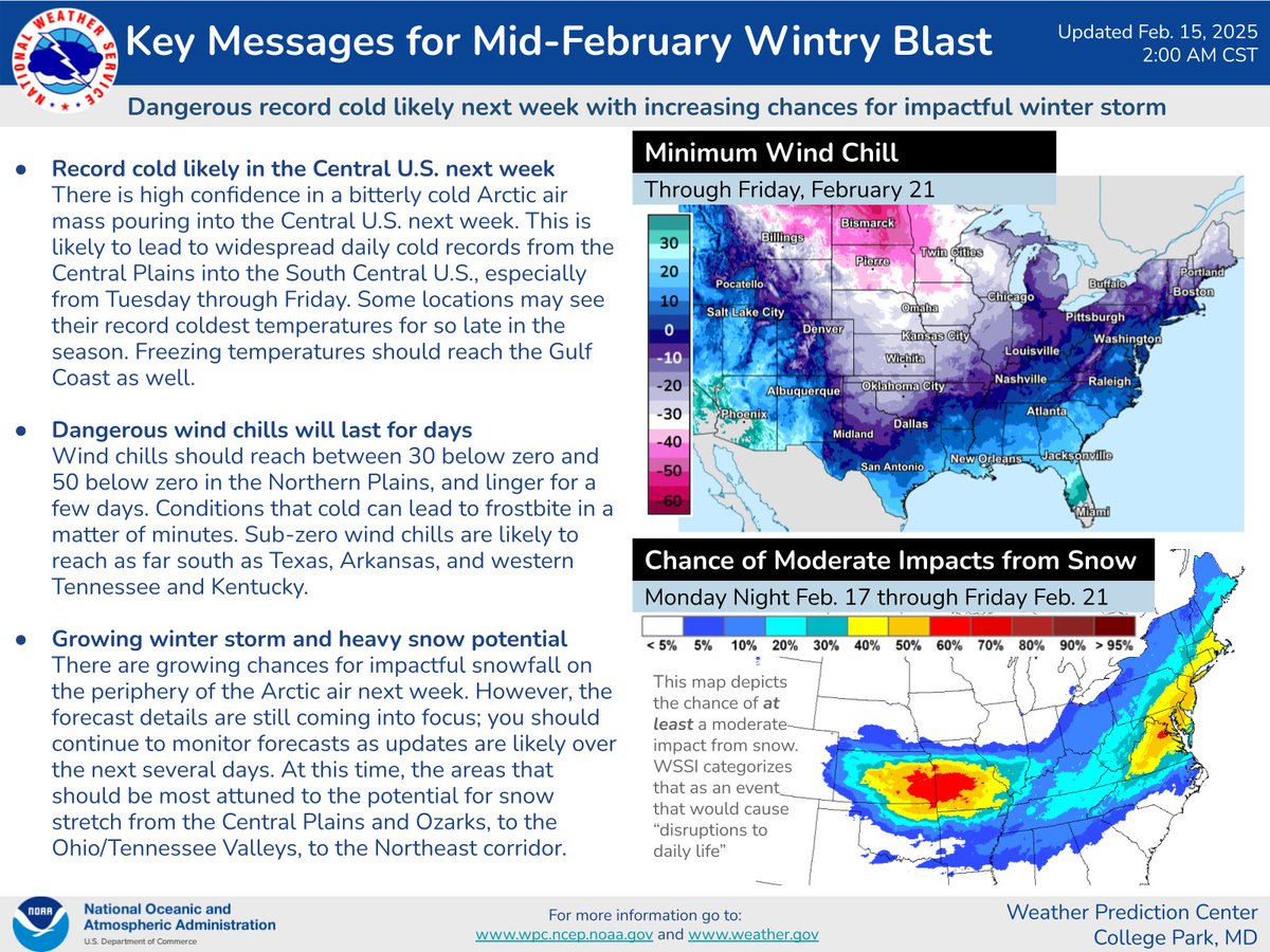
Still 5 days out, but the initial WPC discussion is out. Expect fine tuning for the next several days.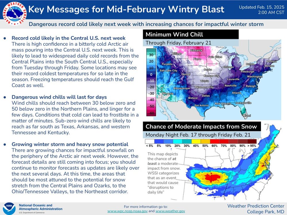
-
February 19-20 Major Winter Storm Threat
Maggie Valley Steve replied to NorthHillsWx's topic in Southeastern States
Please pin this thread! -
2024-2025 Fall/Winter Mountain Thread
Maggie Valley Steve replied to Buckethead's topic in Southeastern States
My low was 24. Snow guns have blowing all night at Cataloochee. Looks like it's going to snow after some rain Sunday afternoon and evening. More wintry weather Tuesday afternoon into Thurday as well! -
2024-2025 Fall/Winter Mountain Thread
Maggie Valley Steve replied to Buckethead's topic in Southeastern States
The afternoon update from the Climate Prediction Center is impressive..thumb.gif.72548b4b2ad018253dbee017fbb8db19.gif)
.gif.6d84e4a2e42f4c1d444b73bbb66e8b1a.gif)
-
2024-2025 Fall/Winter Mountain Thread
Maggie Valley Steve replied to Buckethead's topic in Southeastern States
My point and click forecast has a low of 21 in the morning. Saturday morning has a chance of freezing rain around daybreak and then heavy rain with thunderstorms. Sunday afternoon has a snow chance and snow for Tuesday afternoon into Wednesday. Time to start paying a little closer attention to next week! -
2024-2025 Fall/Winter Mountain Thread
Maggie Valley Steve replied to Buckethead's topic in Southeastern States
I ended up with 3.67 inches of rain for the event. Jonathan Creek is running well above normal.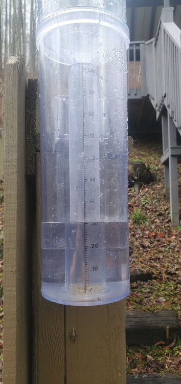
-
2024-2025 Fall/Winter Mountain Thread
Maggie Valley Steve replied to Buckethead's topic in Southeastern States
We've really dodged a bullet today here in the Valley. It's been fluctuating between light to moderate rain the past couple of hours and still stuck at 33. The ground is really saturated now. Fingers and toes crossed that flooding issues do not become a reality. -
2024-2025 Fall/Winter Mountain Thread
Maggie Valley Steve replied to Buckethead's topic in Southeastern States
33 and rain at the house. -
2024-2025 Fall/Winter Mountain Thread
Maggie Valley Steve replied to Buckethead's topic in Southeastern States
Starting the day at 37. -
2024-2025 Fall/Winter Mountain Thread
Maggie Valley Steve replied to Buckethead's topic in Southeastern States
Down to 36 at the house. Cataloochee is reporting 29 now. -
2024-2025 Fall/Winter Mountain Thread
Maggie Valley Steve replied to Buckethead's topic in Southeastern States
The Mountains are now in the Heavy Rainfall area in the Updated WPC Hazard Outlook.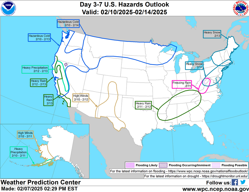
-
2024-2025 Fall/Winter Mountain Thread
Maggie Valley Steve replied to Buckethead's topic in Southeastern States
It's beginning to look like we may have a potential for flooding next week particularly Tuesday through Thursday. Something to keep an eye on. -
2024-2025 Fall/Winter Mountain Thread
Maggie Valley Steve replied to Buckethead's topic in Southeastern States
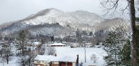
What a glorious 'false spring' day in the Mountains! I hit 66 today which is the highest temperature since last December. Tomorrow looks even warmer and will be a perfect day for a motorcycle ride!

.gif.8d679a754bd9564fa7482e1fc08f63c2.gif)

