Maggie Valley Steve
-
Posts
449 -
Joined
-
Last visited
Content Type
Profiles
Blogs
Forums
American Weather
Media Demo
Store
Gallery
Everything posted by Maggie Valley Steve
-

2024 Spring/Summer Mountain Thread
Maggie Valley Steve replied to Buckethead's topic in Southeastern States
The models are coming around to the idea that another deep trough sets up over the Great Lakes into the Tennessee River Valley next week. Looking like a decent cold front and rain/storm chances increase during the weekend into next week! -
2024 Spring/Summer Mountain Thread
Maggie Valley Steve replied to Buckethead's topic in Southeastern States
Another day of scattered thunderstorms developing across the Mountains. Picked up 3/4 of an inch yesterday afternoon. -
2024 Spring/Summer Mountain Thread
Maggie Valley Steve replied to Buckethead's topic in Southeastern States
Mesoscale Precipitation Discussion 0448 NWS Weather Prediction Center College Park MD 454 PM EDT Sun Jun 16 2024 Areas affected...TN Valley east through the Blue Ridge into Upstate SC Concerning...Heavy rainfall...Flash flooding possible Valid 162053Z - 170230Z Summary...Slow moving thunderstorms with rain rates nearing 2"/hr at times will expand in coverage through the afternoon. This could result in locally more than 3" of rainfall and isolated instances of flash flooding. Discussion...The regional radar mosaic this afternoon depicts a rapid expansion of showers and thunderstorms from central TN eastward through northern GA and into Upstate SC. These storms are developing around the periphery of an intensifying mid-level ridge, and in the vicinity of a stationary front/warm front analyzed by WPC to be waving around the southern Appalachians. Thermodynamics across the region are impressive with PWs measured by GPS of 1.5 to 1.7 inches, around the 90th percentile for the date, overlapping extreme instability analyzed by the SPC RAP to be 3000-4000 J/kg. Into these thermodynamics, weak ascent created via modest upper diffluence, a weak impulse lifting northward, and some upslope flow/isentropic ascent on the 10-15 kts low-level flow is helping to create the ongoing convection. It is likely the environment will remain favorable for additional development through loss of heating several hours from now. The CAMs are generally under-producing the current coverage of convection, so confidence in the exact evolution is modest. However, the robust thermodynamics and weak southerly flow are progged to persist into the evening, and the ingredients suggest that this will support additional convective development until convective overturning or nocturnal stabilization occurs. Thunderstorms will likely remain scattered and pulse in the presence of weak shear, with outflow boundaries and storm mergers contributing to additional development, and these storms have a 40-60% chance (10-20%) for 1+"/hr (2+"/hr) rain rates according to the HREF neighborhood probabilities. These intense rates will also be very slow moving as noted by propagation vectors that are collapsed to just around 5 kts in the presence of weak flow, and it is likely that terrain influences may also cause periods of nearly-stationary cells. Limiting the flash flood risk is that storm lifespans should be modest due the pulse nature, but where storms can repeat or lock in place, even briefly, isolated amounts of 3" or more are possible (20-40% chance) according to the HREF. This area has been generally dry as noted by 7-day AHPS anomalies that are less than 50% resulting in 0-10cm RSM from NASA SPoRT that is only 30-50%. However, there are some wetter soils across TN and in the vicinity of the Blue Ridge Mountains. Although the risk for rapid runoff and flash flooding may be a bit higher in the more saturated soils, or across any urban areas and sensitive terrain features, the slow movement of these intense rates could produce isolated instances of flash flooding anywhere across the region through the evening. Weiss ATTN...WFO...BMX...FFC...GSP...HUN...JKL...LMK...MEG...MRX... OHX...PAH...RNK...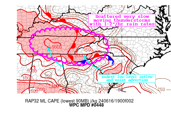
-
2024 Spring/Summer Mountain Thread
Maggie Valley Steve replied to Buckethead's topic in Southeastern States
What an amazing stretch of weather! There's nothing better than mountain living!
-
2024 Spring/Summer Mountain Thread
Maggie Valley Steve replied to Buckethead's topic in Southeastern States
46 this morning in Maggie! -
2024 Spring/Summer Mountain Thread
Maggie Valley Steve replied to Buckethead's topic in Southeastern States
Down to 51 on the Valley floor this morning. Not to shabby for May 29th!! -
2024 Spring/Summer Mountain Thread
Maggie Valley Steve replied to Buckethead's topic in Southeastern States
Just emptied my rain gage from the weekend storms. Surprisingly I got 4.38 inches. I figured it would be over 2 inches, but didn't expect that much. -
2024 Spring/Summer Mountain Thread
Maggie Valley Steve replied to Buckethead's topic in Southeastern States
Storms rolling in from Tennessee starting to show some bowing. Get ready for damaging wind gusts, frequent lightening and very heavy rainfall rates. -
2024 Spring/Summer Mountain Thread
Maggie Valley Steve replied to Buckethead's topic in Southeastern States
BULLETIN - IMMEDIATE BROADCAST REQUESTED Severe Thunderstorm Warning National Weather Service Greenville-Spartanburg SC 603 PM EDT Sun May 26 2024 The National Weather Service in Greenville-Spartanburg has issued a * Severe Thunderstorm Warning for... Macon County in western North Carolina... * Until 700 PM EDT. * At 602 PM EDT, a severe thunderstorm was located near Andrews, moving east at 40 mph. HAZARD...Ping pong ball size hail and 60 mph wind gusts. SOURCE...Radar indicated. IMPACT...People and animals outdoors will be injured. Expect hail damage to roofs, siding, windows, and vehicles. Expect wind damage to trees and power lines. * Locations impacted include... Franklin, Nantahala Lake, Ellijay, Burningtown, Kyle, Rainbow Springs, Wayah Bald, Aquone, Cullasaja, and Cowee. -
2024 Spring/Summer Mountain Thread
Maggie Valley Steve replied to Buckethead's topic in Southeastern States
The next cell in Jackson County is going severe. Not liking the cellular structure of that storm. Lots of lightening with it here in Maggie ahead of the storm. -
2024 Spring/Summer Mountain Thread
Maggie Valley Steve replied to Buckethead's topic in Southeastern States
Yeah the bottom dropped out with moderate to heavy rain here at the house. Could blow up a bit more as it drifts to the NE. -
2024 Spring/Summer Mountain Thread
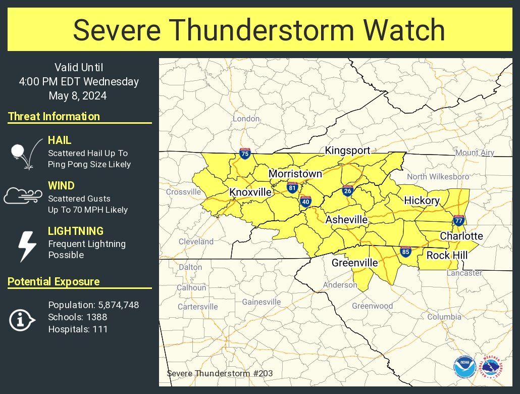
Maggie Valley Steve replied to Buckethead's topic in Southeastern States
Severe Thunderstorm Watch hoisted until 9 PM..png.ea3de904e70fe1a70418d97f88cb9d2c.png)
-
2024 Spring/Summer Mountain Thread
Maggie Valley Steve replied to Buckethead's topic in Southeastern States
Looking like the first meso low may pass N of us, if radar trends hold the next couple of hours. That said, GSP suggests additional storms develope further S with peak heating. Guidance does suggest some of those storms could take on Super Cellular characteristics. More strong storms overnight into tomorrow morning with the cold front. Temperatures mid week may dip into the upper 40’s for lows as well. -
2024 Spring/Summer Mountain Thread
Maggie Valley Steve replied to Buckethead's topic in Southeastern States
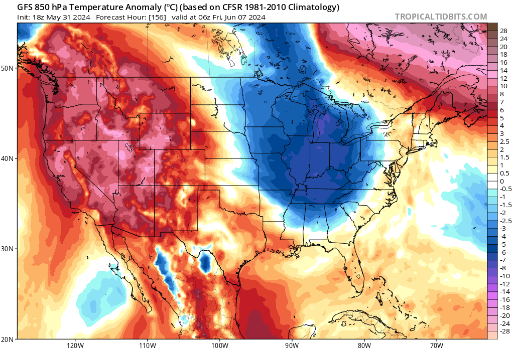
East Coast trough persists. Keep it coming into July/August! -
2024 Spring/Summer Mountain Thread
Maggie Valley Steve replied to Buckethead's topic in Southeastern States
Measured just over an inch the past 24 hours here at the house. Looking like a brief break tomorrow before more weekend storms arrive. -
2024 Spring/Summer Mountain Thread
Maggie Valley Steve replied to Buckethead's topic in Southeastern States
Finally emptied the rain gage for the week. Ended up with 2.88. 44 this morning and warned up to 70 this afternoon. Nice day to clean up all the branches that fell, particularly with the cold front passage. Winds yesterday afternoon gusted to 60 MPH. Tomorrow should be another spectacular day in the Smokies! -
2024 Spring/Summer Mountain Thread
Maggie Valley Steve replied to Buckethead's topic in Southeastern States
The front blew through a little after noon here in Maggie. Temperature did drop to 61, but now with mostly clear skies, the temperature is 71. Tomorrow and most of the weekend looks absolutely beautiful! -
2024 Spring/Summer Mountain Thread
Maggie Valley Steve replied to Buckethead's topic in Southeastern States
I've seen pictures of 3 in hail in Bernardsville with damage reported from hail to cars and house siding. Also reports of hail damage in Mars Hill via Hunter. -
2024 Spring/Summer Mountain Thread
Maggie Valley Steve replied to Buckethead's topic in Southeastern States
The storm the hit Waynesville and Clyde is impressive. Just rain in Maggie at this time. -
2024 Spring/Summer Mountain Thread
Maggie Valley Steve replied to Buckethead's topic in Southeastern States
Watch hoisted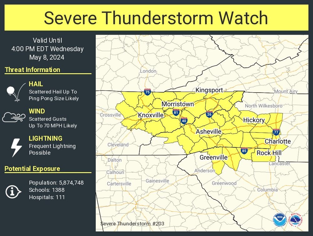
-
2024 Spring/Summer Mountain Thread
Maggie Valley Steve replied to Buckethead's topic in Southeastern States
Big time storm with frequent lightning near Maggie Valley now. This will be the third thunderstorm of the day. -
2024 Spring/Summer Mountain Thread
Maggie Valley Steve replied to Buckethead's topic in Southeastern States
That's a pretty good signal for below average temperatures through week two.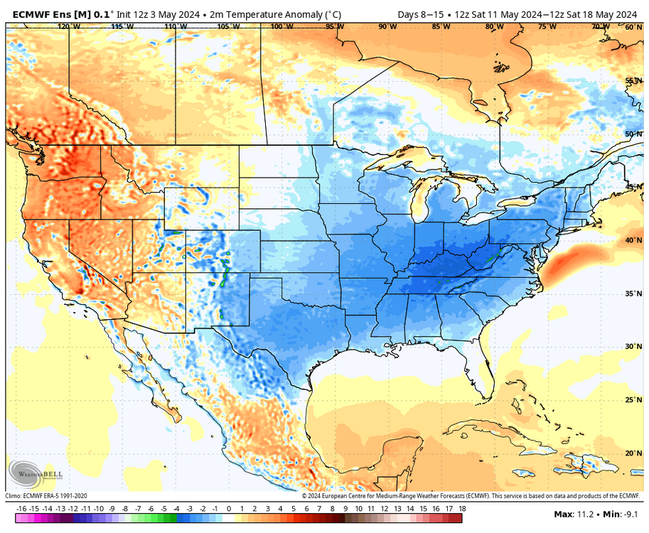
-
2024 Spring/Summer Mountain Thread
Maggie Valley Steve replied to Buckethead's topic in Southeastern States
31 and heavy frost in Maggie this morning. -
2024 Spring/Summer Mountain Thread
Maggie Valley Steve replied to Buckethead's topic in Southeastern States
Looking like more cold on the way late next week.
-
2024 Spring/Summer Mountain Thread
Maggie Valley Steve replied to Buckethead's topic in Southeastern States
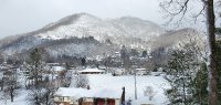
Snowing moderately at Cataloochee.