Maggie Valley Steve
-
Posts
471 -
Joined
-
Last visited
About Maggie Valley Steve

Recent Profile Visitors


-

2025 Spring/Summer Mountain Thread
Maggie Valley Steve replied to Maggie Valley Steve's topic in Southeastern States
Just drove down to Waynesville and there's still some snow on the higher peaks this afternoon. Temperature is still in the upper 40’s currently. It's certainly going to be chilly tonight! -
2025 Spring/Summer Mountain Thread
Maggie Valley Steve replied to Maggie Valley Steve's topic in Southeastern States
We never got out of the mid 40’s today in the Valley. -
2025 Spring/Summer Mountain Thread
Maggie Valley Steve replied to Maggie Valley Steve's topic in Southeastern States
Currently snow showers at Hemphill Bald above Cataloochee. -
2025 Spring/Summer Mountain Thread
Maggie Valley Steve replied to Maggie Valley Steve's topic in Southeastern States
54 here in the Valley with light rain. I measured 2.7 inches in the Guage. -
2025 Spring/Summer Mountain Thread
Maggie Valley Steve replied to Maggie Valley Steve's topic in Southeastern States
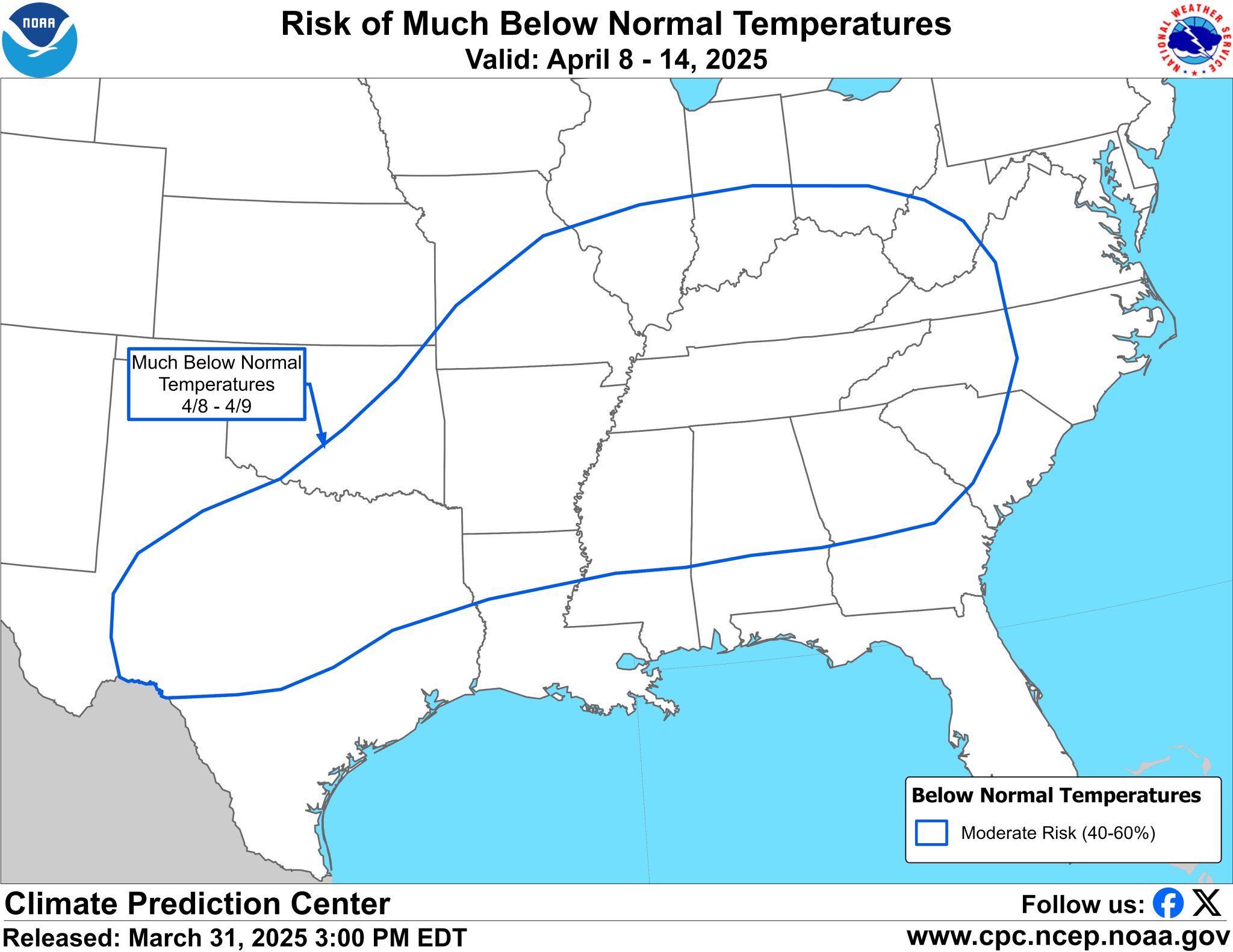
I'm so very thankful we received so much beneficial rain! Everything thing is quickly greening up and our wildfire worries are over! Back to wintertime this week. It's been a couple of years since we've had mid April chances of snow for the higher elevations. -
2025 Spring/Summer Mountain Thread
Maggie Valley Steve replied to Maggie Valley Steve's topic in Southeastern States
I had a high of 82 today. That's late June temperatures, but boy what a change is coming! -
2025 Spring/Summer Mountain Thread
Maggie Valley Steve replied to Maggie Valley Steve's topic in Southeastern States
What beautiful glorious day across the Smokies! Perfect temperature to be out side and clear blue Carolina Skies. I always enjoy when almost an inch of rain brings so much Greenup. I'm going to begin tackling one of the decks in preparation for restraining tomorrow. Hopefully the rain will hold off until late Thursday! -
2025 Spring/Summer Mountain Thread
Maggie Valley Steve replied to Maggie Valley Steve's topic in Southeastern States
After a nice Spring warmup, this is going to shock the system.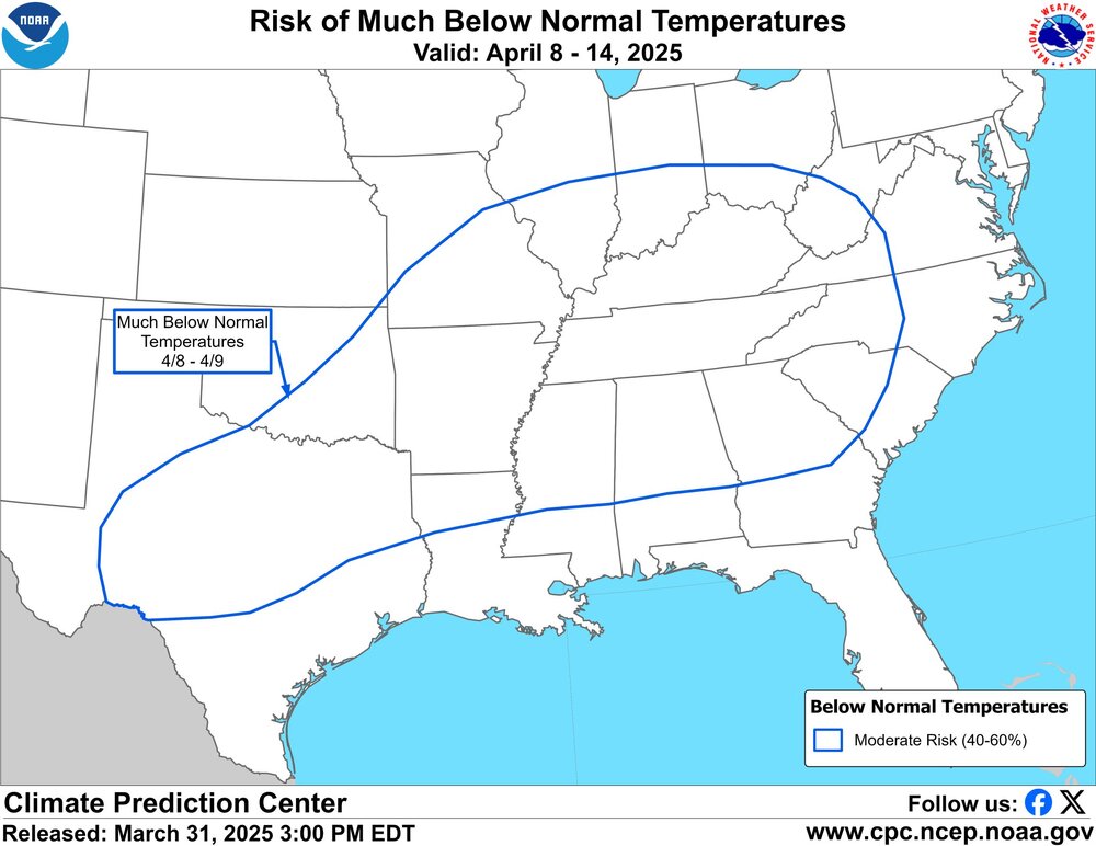
-
2025 Spring/Summer Mountain Thread
Maggie Valley Steve replied to Maggie Valley Steve's topic in Southeastern States
It was great hearing thunder rumbling and heavy showers this morning! We had off and on showers most of the day yesterday and more rain coming today ahead and along the cold front. Looks like additional rainfall Wednesday into Thursday too. I've been enjoying this transition to Spring, but it sure looks like another shot of winter is ahead for next week. -
2025 Spring/Summer Mountain Thread
Maggie Valley Steve replied to Maggie Valley Steve's topic in Southeastern States
6 months ago today our Region was experiencing what is likely the most widespread Major Weather Events in generations from Helene. Currently we continue to live with the aftermath of that Historic Event with wildfires burning across our Mountains. Hopefully our very dry and dangerous wildfire conditions will relax next week with a chance of some beneficial rainfall. I hope all of our neighbors are doing well! -
2025 Spring/Summer Mountain Thread
Maggie Valley Steve replied to Maggie Valley Steve's topic in Southeastern States
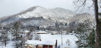
I ended up with a half inch of measurable snow, but it took about 4 hours to finally begin to stick. My low was 24 this morning. It's beginning to look like an active pattern with a rather vigorous Eastern Trough persisting into early April. The impact the the stratospheric Polar Vortex collapse in early March is being felt. -
2025 Spring/Summer Mountain Thread
Maggie Valley Steve replied to Maggie Valley Steve's topic in Southeastern States
Ground is covered to the Valley floor. I'll call it moderate snow with very little wind. -
2025 Spring/Summer Mountain Thread
Maggie Valley Steve replied to Maggie Valley Steve's topic in Southeastern States
It's starting to lay on the decks and vegetation. Temperature down to 34 now. -
2025 Spring/Summer Mountain Thread
Maggie Valley Steve replied to Maggie Valley Steve's topic in Southeastern States
Flurries at the house and 38. -
2025 Spring/Summer Mountain Thread
Maggie Valley Steve replied to Maggie Valley Steve's topic in Southeastern States
Flurries at Cataloochee now.