Violentweatherfan
-
Posts
3,678 -
Joined
-
Last visited
Content Type
Profiles
Blogs
Forums
American Weather
Media Demo
Store
Gallery
Everything posted by Violentweatherfan
-

E PA/NJ/DE Summer 2025 Obs/Discussion
Violentweatherfan replied to Hurricane Agnes's topic in Philadelphia Region
You gotta be a 100 degrees now -
E PA/NJ/DE Summer 2025 Obs/Discussion
Violentweatherfan replied to Hurricane Agnes's topic in Philadelphia Region
I think it’s worse up here. I worked with people that grew up and lived in Fla and I could see the defeated by our heat up here -
E PA/NJ/DE Summer 2025 Obs/Discussion
Violentweatherfan replied to Hurricane Agnes's topic in Philadelphia Region
And this was supposed to be the heat dome from hell and looks like it’s gonna turnout to be a three day heat wave. Im sure the gfs will fall in line -
E PA/NJ/DE Spring 2025 Obs/Discussion
Violentweatherfan replied to PhiEaglesfan712's topic in Philadelphia Region
Need the sun to pop out and raise the temperature -
E PA/NJ/DE Spring 2025 Obs/Discussion
Violentweatherfan replied to PhiEaglesfan712's topic in Philadelphia Region
With the MJO phase in the circle of death, yeah no. -
E PA/NJ/DE Spring 2025 Obs/Discussion
Violentweatherfan replied to PhiEaglesfan712's topic in Philadelphia Region
Wednesday looks great with a shot at 70 degrees -
E PA/NJ/DE Winter 2024/25 Obs/Discussion
Violentweatherfan replied to JTA66's topic in Philadelphia Region
I don’t think I saw any blocking during any of the LR model runs -
E PA/NJ/DE Winter 2024/25 Obs/Discussion
Violentweatherfan replied to JTA66's topic in Philadelphia Region
Sun angle also skews(no pun) 850mb temps as well. Just because 850mb temperature map readings might be below 32 degrees actually temp will be higher. -
E PA/NJ/DE Winter 2024/25 Obs/Discussion
Violentweatherfan replied to JTA66's topic in Philadelphia Region
Their call is a favorite of mine. -
E PA/NJ/DE Winter 2024/25 Obs/Discussion
Violentweatherfan replied to JTA66's topic in Philadelphia Region
It’s just banter, but I wanted a laugh from it. Like a weenie I’m reading long range thread in the MA forum getting my hopes up for feb28 to mar 2 period. Only to have them crushed -
E PA/NJ/DE Winter 2024/25 Obs/Discussion
Violentweatherfan replied to JTA66's topic in Philadelphia Region
Spring is definitely closer than we thought. I’m hearing Red winged Blackbirds already -
E PA/NJ/DE Winter 2024/25 Obs/Discussion
Violentweatherfan replied to JTA66's topic in Philadelphia Region
Info was pretty cool, I didn’t fully understand 500mb maps but I have a better idea of them now. -
E PA/NJ/DE Winter 2024/25 Obs/Discussion
Violentweatherfan replied to JTA66's topic in Philadelphia Region
Pretty cool video regarding 500mb maps and spring storm/severe -
Judging by the AFD it was probably a Miller B. When probably February 2010
-
E PA/NJ/DE Winter 2024/25 Obs/Discussion
Violentweatherfan replied to JTA66's topic in Philadelphia Region
So it the ULL captures the piece of energy too late, therefore not pulling the storm up the coast on the Euro where it showed snow amounts in feet. Ideally where would we like the capture/phase take place. Definitely overland but where Tennessee? -
E PA/NJ/DE Winter 2024/25 Obs/Discussion
Violentweatherfan replied to JTA66's topic in Philadelphia Region
This is the first time I’ve heard the term “dead upper level low”. So we are dealing with ULL’s that are Walkers? -
E PA/NJ/DE Winter 2024/25 Obs/Discussion
Violentweatherfan replied to JTA66's topic in Philadelphia Region
Gotta be climate change screwing with the Pacific Ocean water temps and effing up the PAC Jet skewing ridging out west -
E PA/NJ/DE Winter 2024/25 Obs/Discussion
Violentweatherfan replied to JTA66's topic in Philadelphia Region
Yeah I saw that but the intense winds was that all. -
E PA/NJ/DE Winter 2024/25 Obs/Discussion
Violentweatherfan replied to JTA66's topic in Philadelphia Region
Is that it? -
E PA/NJ/DE Winter 2024/25 Obs/Discussion
Violentweatherfan replied to JTA66's topic in Philadelphia Region
Alright, it’s been fun I’ll see you all next year. -
E PA/NJ/DE Winter 2024/25 Obs/Discussion
Violentweatherfan replied to JTA66's topic in Philadelphia Region
Well that needs to get on board or get the F**k gone. -
E PA/NJ/DE Winter 2024/25 Obs/Discussion
Violentweatherfan replied to JTA66's topic in Philadelphia Region
Bluewave from the NYC forum mentioned how the pacific was impacting our storm chances. Potentially due to climate change, heating up the pacific and making the flow progressive and effing up the jet stream -
E PA/NJ/DE Winter 2024/25 Obs/Discussion
Violentweatherfan replied to JTA66's topic in Philadelphia Region
Are you sure, I thought this weekend’s storm was to create the block. There is just a small piece of energy that Steve and Will mentioned earlier. -
E PA/NJ/DE Winter 2024/25 Obs/Discussion
Violentweatherfan replied to JTA66's topic in Philadelphia Region
Dude no matter how much I approach potential storms with rationale and logic I still get pissed off and through a snow weenie tantrum. And I manage expectations for a living, and do it really well. But when it comes to this, the potential it had or has…the wheels come off -
E PA/NJ/DE Winter 2024/25 Obs/Discussion
Violentweatherfan replied to JTA66's topic in Philadelphia Region
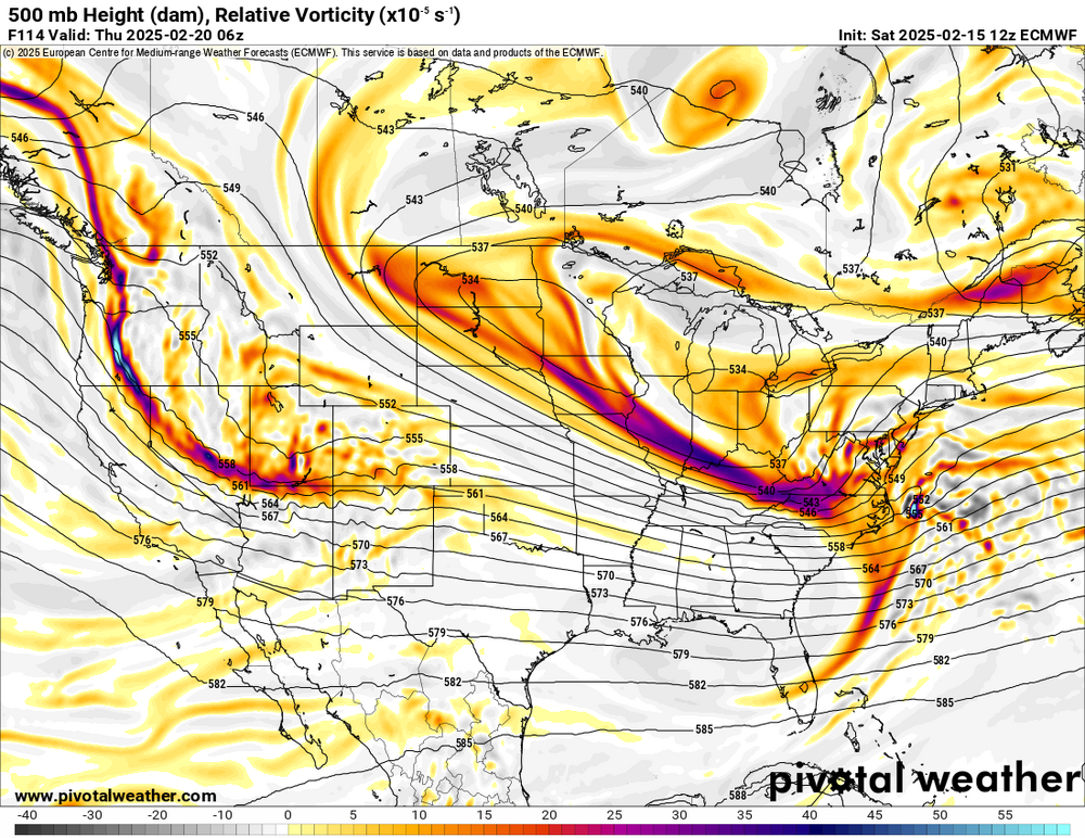
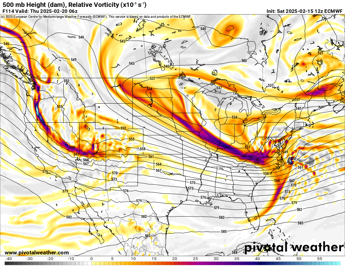
Steve D mentioned in one of his videos earlier in the week regarding a piece of energy up north just like orh from the NE forum is saying. Here is the image for reference