

Violentweatherfan
-
Posts
3,461 -
Joined
-
Last visited
Content Type
Profiles
Blogs
Forums
American Weather
Media Demo
Store
Gallery
Everything posted by Violentweatherfan
-

E PA/NJ/ DE Winter 2021-22 OBS Thread
Violentweatherfan replied to JTA66's topic in Philadelphia Region
Damn, I was off on that. Thanks, still hanging in there which is good -
E PA/NJ/ DE Winter 2021-22 OBS Thread
Violentweatherfan replied to JTA66's topic in Philadelphia Region
Yeah you can see it gets nudged out of the way but it looks like it prevents it from being a complete miss. -
January 28-30th Possible Nor'easter
Violentweatherfan replied to Rjay's topic in New York City Metro
Start and stop times are what will impact accumulations. -
E PA/NJ/ DE Winter 2021-22 OBS Thread
Violentweatherfan replied to JTA66's topic in Philadelphia Region
Man I'd like to see that with longitude and latitude. I lifted this from the NYC forum, @Doorman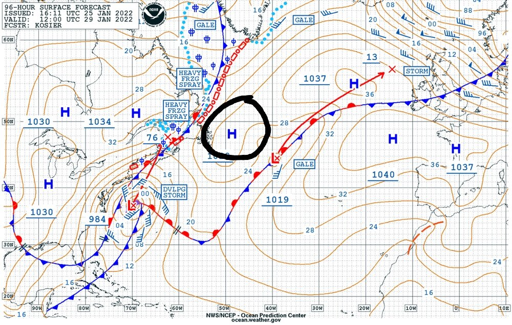
-
E PA/NJ/ DE Winter 2021-22 OBS Thread
Violentweatherfan replied to JTA66's topic in Philadelphia Region
Yesterday -
E PA/NJ/ DE Winter 2021-22 OBS Thread
Violentweatherfan replied to JTA66's topic in Philadelphia Region
Anyone have a 500MB map of the Euro ensemble. Yesterday there was a 50/50 HP, or I guess you call it a 50/50 ridge. I'd like to see if it's location changed any causing the eastward movement -
E PA/NJ/ DE Winter 2021-22 OBS Thread
Violentweatherfan replied to JTA66's topic in Philadelphia Region
Ignore the snow accumulation and precip maps, but check out the temp and humidity maps. -
E PA/NJ/ DE Winter 2021-22 OBS Thread
Violentweatherfan replied to JTA66's topic in Philadelphia Region
Oops, I have you confused with a different poster, 3-6 will verify. I had you out in Bensalem. -
E PA/NJ/ DE Winter 2021-22 OBS Thread
Violentweatherfan replied to JTA66's topic in Philadelphia Region
I think I also read that the NAM and the Euro also tend to overamplify phasing. -
E PA/NJ/ DE Winter 2021-22 OBS Thread
Violentweatherfan replied to JTA66's topic in Philadelphia Region
This is doable, at this point I do think we'll see snow. I should see those amounts but in your case I'd temper that a bit. -
E PA/NJ/ DE Winter 2021-22 OBS Thread
Violentweatherfan replied to JTA66's topic in Philadelphia Region
Tonight's run will be the key -
E PA/NJ/ DE Winter 2021-22 OBS Thread
Violentweatherfan replied to JTA66's topic in Philadelphia Region
Don't forget it has performed poorly this year. -
E PA/NJ/ DE Winter 2021-22 OBS Thread
Violentweatherfan replied to JTA66's topic in Philadelphia Region
Ignore the WxBell clown maps -
E PA/NJ/ DE Winter 2021-22 OBS Thread
Violentweatherfan replied to JTA66's topic in Philadelphia Region
'96 was just massive, it started around 2:00AM Sunday snowed till Monday afternoon. -
E PA/NJ/ DE Winter 2021-22 OBS Thread
Violentweatherfan replied to JTA66's topic in Philadelphia Region
PD II was a SWIFE overrunning event too. -
E PA/NJ/ DE Winter 2021-22 OBS Thread
Violentweatherfan replied to JTA66's topic in Philadelphia Region
Another thing to keep in mind is low pressure readings don't equate to increased snow totals. -
E PA/NJ/ DE Winter 2021-22 OBS Thread
Violentweatherfan replied to JTA66's topic in Philadelphia Region
Minus the dryslot please. -
E PA/NJ/ DE Winter 2021-22 OBS Thread
Violentweatherfan replied to JTA66's topic in Philadelphia Region
Damn you might be a bit West -
E PA/NJ/ DE Winter 2021-22 OBS Thread
Violentweatherfan replied to JTA66's topic in Philadelphia Region
Almost new thread time... -
E PA/NJ/ DE Winter 2021-22 OBS Thread
Violentweatherfan replied to JTA66's topic in Philadelphia Region
It's only Tuesday, if trends continue and holds serve til Thursday just might be time to get excited -
E PA/NJ/ DE Winter 2021-22 OBS Thread
Violentweatherfan replied to JTA66's topic in Philadelphia Region
'78 definitely eased the pain of a snowless decade. -
January 28-30th Possible Nor'easter
Violentweatherfan replied to Rjay's topic in New York City Metro
Hey I know it's only Tuesday, but nice call T -
E PA/NJ/ DE Winter 2021-22 OBS Thread
Violentweatherfan replied to JTA66's topic in Philadelphia Region
Lol, just about to mention a snow map I saw in the Mid Atlantic forum -
January 28-30th Possible Nor'easter
Violentweatherfan replied to Rjay's topic in New York City Metro
January 6/7 1996 was a pure Miller A. While the Boxing Day storm may have grazed the GOM, it really developed off the Atlantic coast. With Miller A storms everyone gets snow and there really isn't much of a screw zone as there are with Miller B storms. -
January 28-30th Possible Nor'easter
Violentweatherfan replied to Rjay's topic in New York City Metro
Treat it as what it is, a single run. The ensemble is 51 samples of a single run.

