LakePaste25
-
Posts
367 -
Joined
-
Last visited
Content Type
Profiles
Blogs
Forums
American Weather
Media Demo
Store
Gallery
Everything posted by LakePaste25
-
It is indeed too early for this to start showing up on the medium range ensembles. The MJO progression and La Niña strengthening all allude to the traditional Nina February climo taking hold between after mid-month and early February. But as discussed yesterday, it’s not a sole predictor. Wildcards are there, such as the SPV. For now, I would simply lean towards this progression.
-
-
Not in Buffalo but i live near Erie. We don’t really have “pure” wall to wall winters. 13-14/14-15 had some brief warmups in the 40s. I think 76-77 came close but even had a day or two of 50+ in December. We are quite prone to rapid warmups here west of the mtns. But, during our good, below normal temp winters will usually have snow on the ground all winter if not most of it, and the brief warmup periods will glaciate the snowpack before we cool down again and add more. For true wall to wall pure winters that don’t get above the 40s, you’d probably want to be somewhere like Caribou, International Falls, or Fairbanks. But even Caribou has been getting these brief warmups lately and even had a green Christmas last year.
-
Same theme as January 2011. The GOA ridge plus the blocking is good enough to do the job. It is when the pacific blocking is back towards the Aleutians, the atlantic and AO blocking might not save the pattern (bootleg SE ridge).
-
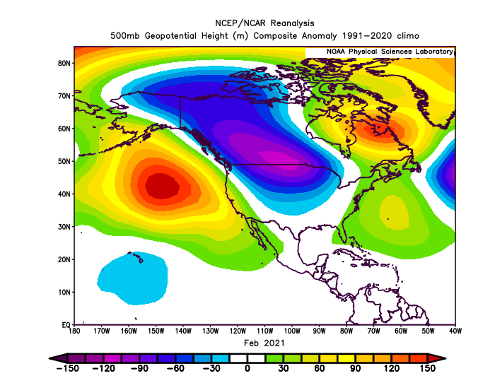
I believe late January 2021 had an SSW, which lead to less of a traditional Nina signal and likely saved Feb.
-
Yep, that february ‘11 outcome is not just a possibility, but probably leans more likely than not barring any serious SPV warming. But most won’t care if they can score a big storm or two in January to hit average. Just like how a winter with a decent amount of cold, but with low snow might get rated poorly.
-
You can still get an Aleutian ridge with a -WPO. That’s exactly what the weeklies show starting right after MLK weekend.
-
The change is still well over 300 hours away. It is too far out to really discern what the trough axis will be and where the frozen precip. will be most favored.
-
I guess I should clarify - I am not saying it will be a snowy pattern for I-95 the first half of January. My call is that it will be cold. I’m not really able to discern whether it will be snowy, partly because I don’t live there and also, some of these events are tough to predict at medium range timescale. That said, I do think there is a risk of -PNA mid to late month. I’ve been saying that for a few days now. Whether that is a -PNA that digs to San Diego and we see a full SE ridge torch or it is more mellow, that remains to be seen at this point. I will cross that bridge when we get closer in time.
-
To me, that looks like a storm system from the GOA low breaks off as the block tries to retrograde westward. With blocking over the top, I don’t see cutting with that look verbatim as it traverses through the plains. Now, if that look changes and energy gets buried in the southwest, then no block will stop that from cutting. We did this see frequently in 22-23.
-
While it does delay the cold and prolong the jet extension against other guidance, it isn’t really showing any canonical -PNA Nina pattern.
-
No indication that we are returning to a -PNA prior to mid-January. Everything looks on track to turn colder to start the New Year.
-
Part of this is due to a combination of bad luck and lack of prolonged cold. If we get a cold shot that only lasts 1 week, one needs to get lucky on the coast. If we get cold that lasts 3-4 weeks, the coast is more likely to score simply by probability laws. Take January 2022, for example. The 1 week cold shots work better here near the lakes because we don’t need the atlantic or the gulf, we just need a northern stream trough over warm lake waters.
-
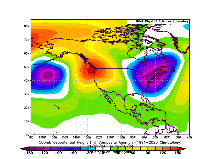
A trough axis centered more west isn’t terrible for I-95 snow threats. The late november to early december pattern of clippers dropping into Michigan and the ridge axis over BC produced plenty of lake snow here, but it was too far east to produce anything appreciable for the I-95 corridor.
-
January looks on track to start cold, at least shortly after the New Year due to a pacific jet retraction to a more favorable wave breaking/exit position. The question then becomes, how long does this last? Some guidance retracts the jet further to the more traditional -PNA/SE ridge by mid-January, while others hold off until the end of the month. I am going with a blend, with the cold lasting until the 4th week of january. By early February the latest, we will see a return to the full SE ridge Nina pattern.
-
The models have certainly trended towards a pre-christmas cold shot, on average lasting about 5 days. The only thing I will point out is that we shouldn’t verify a forecast with a forecast. Before jumping the gun on calling certain outlooks wrong, we should wait and see how this actually plays out.
-
The Christmas pattern change idea floating around social media is likely rushed (when hasn’t it?). Most of us enjoy cold weather during the Christmas holiday, so the usual wishcasting ensues. We are likely dealing with phase 6 before the pattern potentially becomes more favorable after the New Year.
-
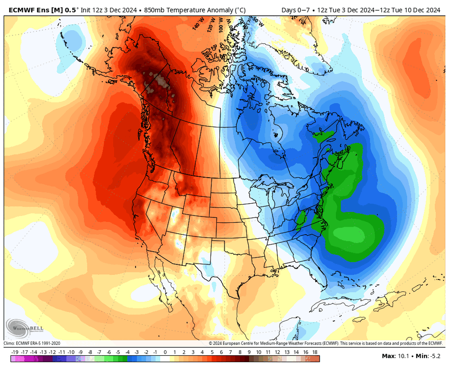
Most of Canada stays cold through the entire run. While we will get warmer, it is a far cry from last December when we had the pacific jet extended all the way to the west coast, and it was just torching our cold source region with mild pacific air. Our source region for cold will get some nice chilling hours, which means any favorable pattern shift will easily bring cold air south later in the month.
-

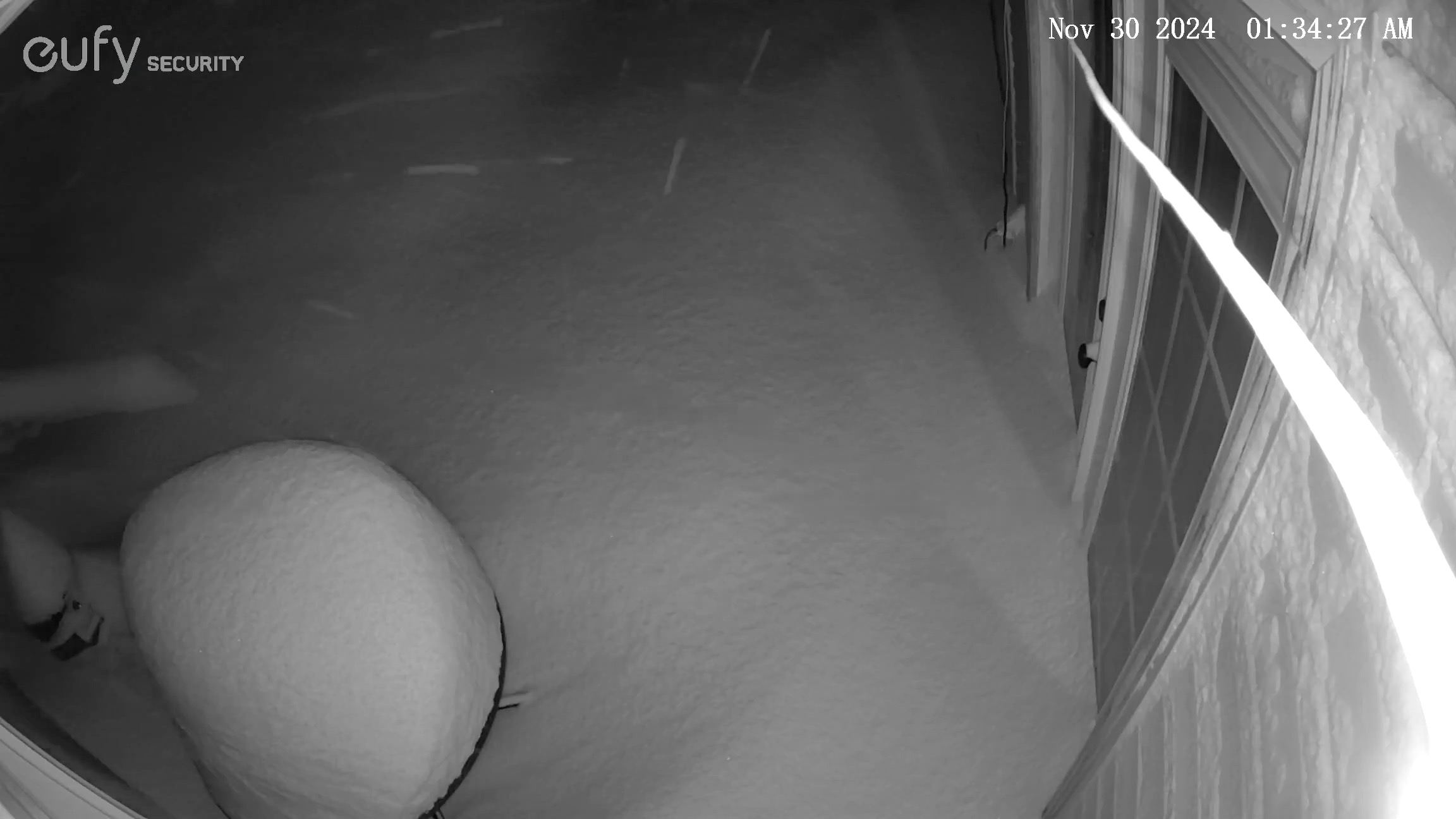
Major Lake Effect Snowstorm: Nov 29-Dec 4th
LakePaste25 replied to BuffaloWeather's topic in Upstate New York/Pennsylvania
House cam update. Down in NoVA visiting family, but I’ll be back up there tomorrow.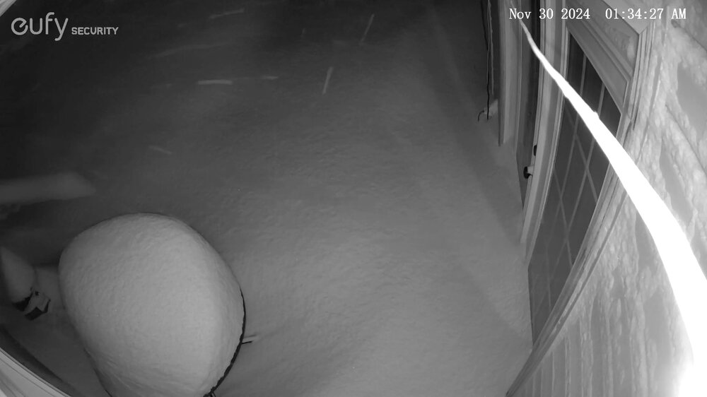
-
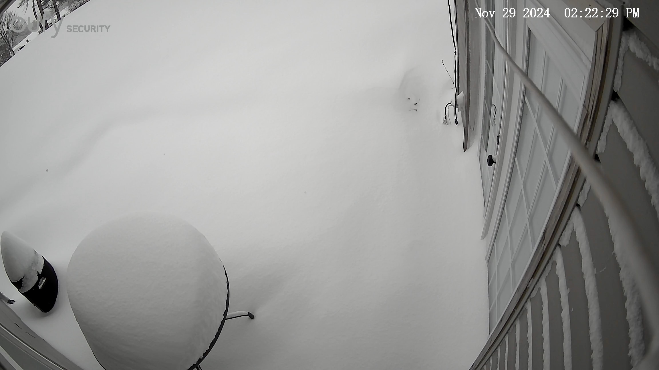
Major Lake Effect Snowstorm: Nov 29-Dec 4th
LakePaste25 replied to BuffaloWeather's topic in Upstate New York/Pennsylvania
I’m about 6 miles southeast of Erie, PA.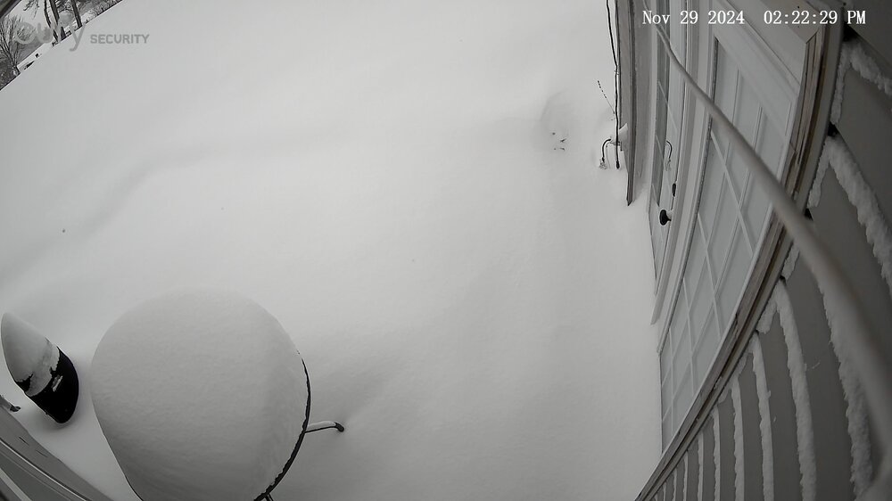
-
The long-term climate models expected us to be in more frequent el niño episodes as SSTs and overall background state warmed. Recently we have seen the opposite - more frequent la niña events. It could be that we will eventually see the expected increase of el niño events, while this recent streak of la niña was just a temporary state.
-
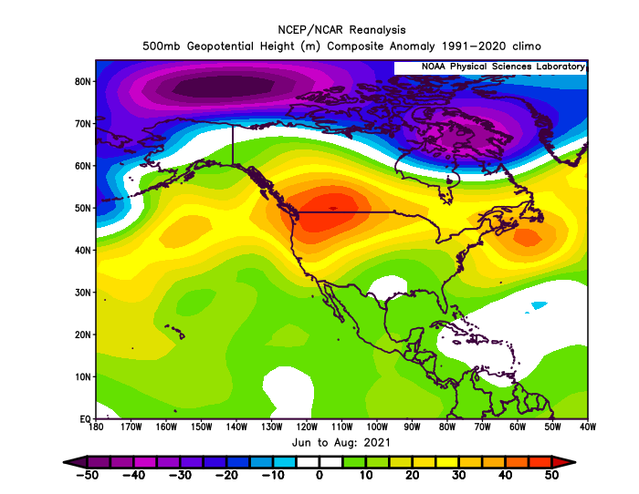
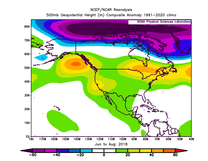
The correlation you’re showing makes sense, but I would add the caveat (in my opinion) that PNA doesn’t have as much of an influence on our summer compared to winter due to shorter wavelengths. You can have indexed - or + PNA that occupies different real estate that might give us a downstream ridge. I do think the NAO blocking however, has a big influence. Here’s two of our recent hotter summers for example (you can find plenty more), 2018 and 2021 which had a predominately +PNA, but also an upstream eastern US ridge. Not a lot of -NAO during both of those.
-
Not to derail the conversation, but one must also look at snowfall frequencies and amounts, i.e. climates that rely on “big dog” events versus those that rely on more frequent, smaller events to reach snowfall averages. Here, we are finding that cities such as Buffalo are not seeing the same regression to lower snowfall seasons as places like Syracuse, Erie, and Cleveland where all 3 cities are 5+ years in a row of below normal snowfall. Places that rely on more frequent smaller events are finding that the increase in moisture does not outweigh the decrease in # of events due to more frequent warm spells. For what it’s worth, I generally lump most of the I-95 cities into places that favor “big dog” events just like Buffalo, which means these areas can withstand some warming and even see increases in snowfall averages, simply because you don’t need it to be cold all winter to get these huge events. The 15-16 winter is a great example of this for NYC.
-
Winds and waves were roaring at Ripley Beach. Generally just 2-4” at my inland area but will stay very cold through this cold snap with temperatures struggling to get out of the teens during most of the week.
-
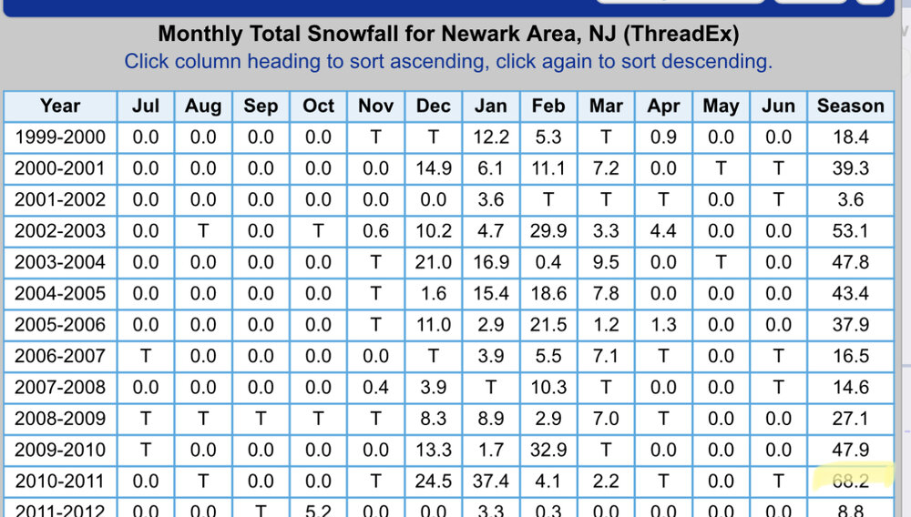
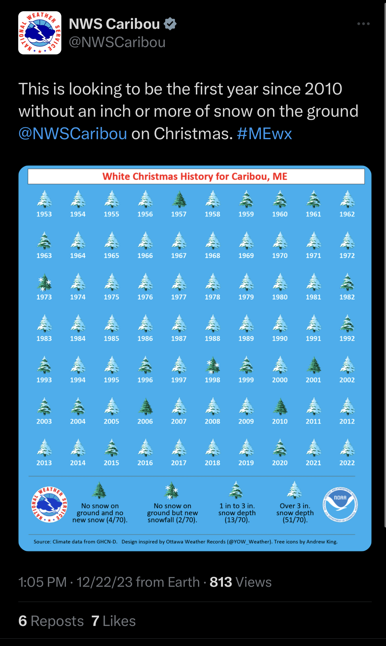
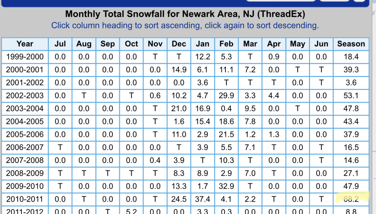
The last time that Caribou recorded less than an inch of snow on the ground was December 2010. In the same winter (2010-2011), EWR recorded 68.2” of snow.