jimmosk
-
Posts
122 -
Joined
-
Last visited
Content Type
Profiles
Blogs
Forums
American Weather
Media Demo
Store
Gallery
Everything posted by jimmosk
-

E PA/NJ/DE Spring 2026 Obs/Discussion
jimmosk replied to PhiEaglesfan712's topic in Philadelphia Region
Some sleet mixing in with the rain in Swarthmore. Still mostly rain, though. -
A- Swarthmore PA
-
Did they get it right for more people, or for more acres? And which one is more important?
-
Just brushed off my car -- not a completely futile effort, since it means there'll be somewhat less snow on it in the morning. It was about six inches deep, though probably an inch or two more fell on it, what with compaction. Not bad given that the snow only started sticking around five hours earlier!
-
Like fiipping a switch in the last ten minutes, from all fairly light rain to mostly medium-heavy snow. Still melting on contact, even on grass.
-
The Byrne Plaza webcam (in Wildwood NJ) is a pretty fun watch at the moment: https://wildwoodsnj.com/view-webcam/
-
What the grep was that?
-
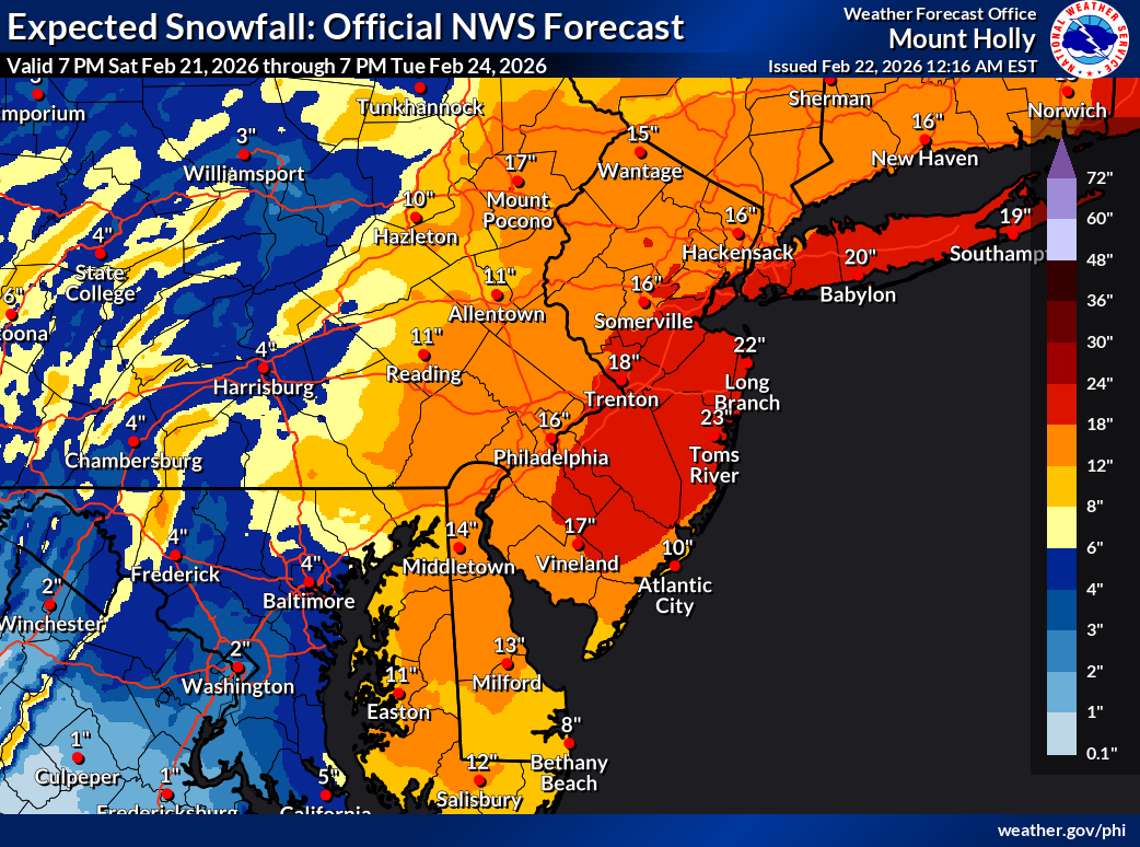
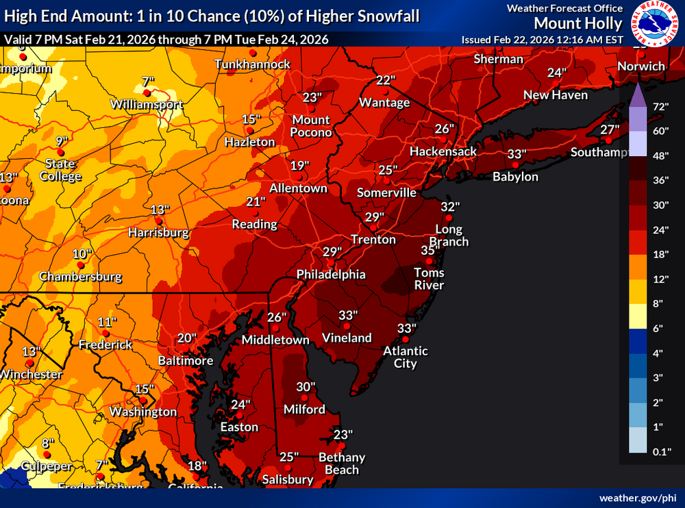
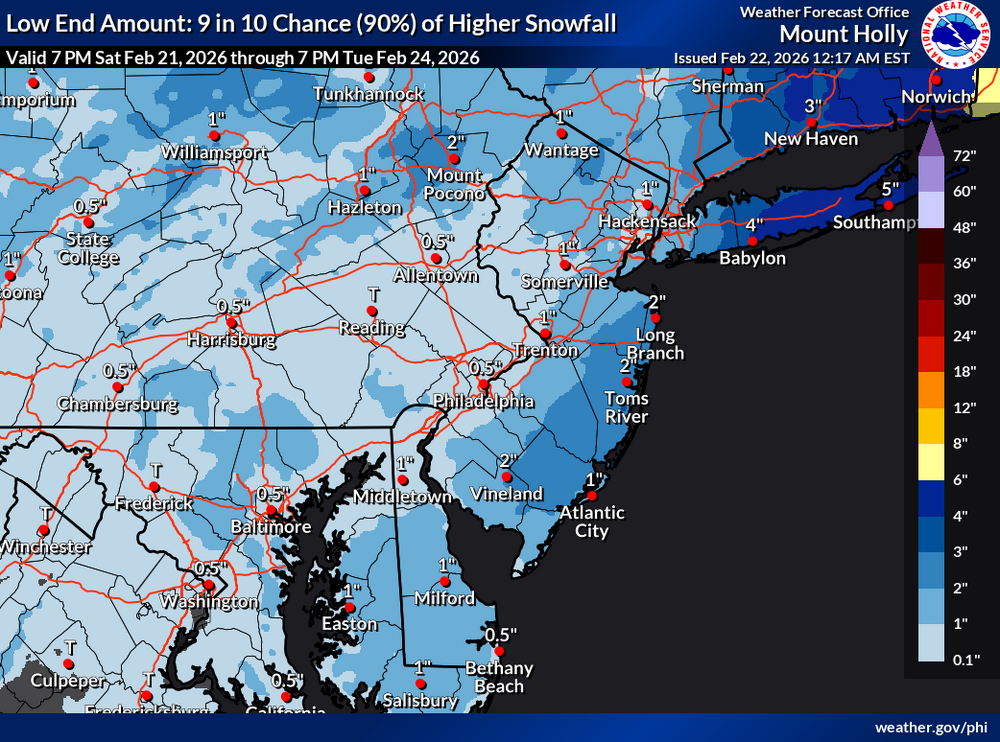
Mt Holly's latest maps, released at 12:15am. The range from 10% to 90% is unreal.

-
There's a 10%, 90%, and best guess, along with many maps for % chance of getting more than a certain number of inches of snow, all at https://www.weather.gov/phi/winter
-
E PA/NJ/DE Winter 2025-26 Obs/Discussion
jimmosk replied to LVblizzard's topic in Philadelphia Region
I am somewhat stunned to discover that, if the temperature goes up high enough, snow will actually turn into a liquid. -
I give that analogy at least a nine, possibly a ten. Username checks out.
-
How hard were "the pros" hit by DOGE cuts last year?
-
Saturday night/Sunday 12/13-12/14 Jawn
jimmosk replied to Ralph Wiggum's topic in Philadelphia Region
That was as of 0700 AM. There was still another hour or two to go at that point, so maybe the final amount will be more like 3? -
I just did the most I possibly could to ensure we get at least one more major snowstorm this season: I put my snow boots back into storage.
-
https://meteor.geol.iastate.edu/~ckarsten/cobb/cobb_help.pdf And here's a comparison of several methods. I found the colored charts about halfway through pretty eye-opening: https://repository.library.noaa.gov/view/noaa/55878/noaa_55878_DS1.pdf
-
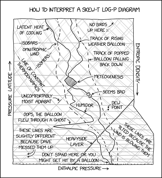
Yep, this is about how unclear I am when looking at a Skew-T Log-P.
-
Yep. A few miles west of PHL we may have gotten one inch more, though the snow is nearly gone already.
-
And one final brush-off, with about three-quarters of an inch, maybe a bit more. I'd put my total at 5.25". A great snow day, "just like the ones I used to know".
-
Just went back out and did a second brushing, three and a half hours after the first. About 2.5" of fluffiness. Swarthmore's likely going to cross the 5" mark before this is done.
-
Brushed off my car for the first time this storm. 2" so far, maybe a smidge more.
-
When do the SREF plumes update? I swear each run used to come out around 5:00 am & pm and 11:00 am & pm, but now they seem to get updated much later than that...
-
I just whisked the snow off my car -- about 1.5" of it.
-
E PA/NJ/DE Winter 2023-2024 OBS/Discussion
jimmosk replied to The Iceman's topic in Philadelphia Region
At the moment we're getting a flizzard in Swarthmore -- fairly dense, fast-blowing, teeny flakes that don't wind up affecting visibility that much. -
It's quite the flizzard here. Pixiedust flakes, swirling everywhere in gusts of 35ish mph.