
Stx_Thunder
-
Posts
301 -
Joined
Content Type
Profiles
Blogs
Forums
American Weather
Media Demo
Store
Gallery
Everything posted by Stx_Thunder
-

Texas 2025 Discussion/Observations
Stx_Thunder replied to Stx_Thunder's topic in Central/Western States
40s showing up in ETX even Tuesday afternoon now on 12z GFS today. -
Texas 2025 Discussion/Observations
Stx_Thunder replied to Stx_Thunder's topic in Central/Western States
I kind of doubt there's going to be any real snow accumulation with sfc temps hovering around (even above) 32 F, and such un-realistic 850Mb temp projections in ETX, Tuesday. Looks more like a sleet event, and ice storm in SETX. After this week, that looks to be it for any more real Arctic air intrusions for the rest of the season looking at the CFS. Even GEFS & EPS projections are going warmer (than things have been lately) into February. AO is also really starting to trend in a positive phase as well going forward. -
Texas 2025 Discussion/Observations
Stx_Thunder replied to Stx_Thunder's topic in Central/Western States
Overall, this next Arctic air intrusion is just going to be a glancing blow.. with 40s back on the maps by Wednesday (which I'm not surprised anyone has mentioned here yet). Even in NTX (possibly even Monday too in CTX), on both GFS & Euro. And even on NAM. Which handles these polar/arctic air intrusions the best. And with the AO having already been in a positive phase to now, I can 100% say with confidence it's certainly not going be anything like the 2021 chill (like some were alluding to here.. because of the crazy as usual Canadian output. I guess...). Even Canadian itself has finally started to back off on its absolutely insane junk temp projections from the past several days or so. Except on Wednesday morning lows. Still going down to < 0 F not far north of Houston... The well-below freezing 850Mb temp projections on GFS & Euro also do not look realistic to me. Since even both of those reliable globals are showing the core of the coldest air has trended well northeast over the Great Lakes region. So I doubt there's going to be any real snow accumulation early this week in ETX/SETX. That's about the only winter wx that's actually going to be worth watching for this "outbreak" going into Tuesday morning. I'd be lucky to even see Sleet coming down here in STX (away from any FZRA potential). -
Texas 2025 Discussion/Observations
Stx_Thunder replied to Stx_Thunder's topic in Central/Western States
Would not count on it. AO (Arctic Oscillation) is trending back to + phase for later January. Just FYI. -
Texas 2025 Discussion/Observations
Stx_Thunder replied to Stx_Thunder's topic in Central/Western States
DFW still reporting light snow as of 5:00 am. Starting to see some enhanced echos develop on base radar right now in & around the metro area, moving east. -
Texas 2025 Discussion/Observations
Stx_Thunder replied to Stx_Thunder's topic in Central/Western States
Seeing that shifted northerly flow now on Dallas VWP radar and surface obs, up to 3 Kft. 'Doesn't look like too much more to go around tonight though for the rest of this winter wx event. -
Texas 2025 Discussion/Observations
Stx_Thunder replied to Stx_Thunder's topic in Central/Western States
CAA coming back in the LLs by mid-evening into the area. Just as I wrote in that earlier post. -
Texas 2025 Discussion/Observations
Stx_Thunder replied to Stx_Thunder's topic in Central/Western States
Not when it's southeasterly in TX (out of the Gulf) in the lowest levels because it definitely both warms & moistens, decreasing wet-bulbing a lot faster than if southwest. I definitely saw that in action today. That was really the 'monkey in the wrench' in this setup. Overall, this whole winter wx forecasting scenario has been nothing short of interesting. No one really knew how it was actually going to pan out. Main thing is, it did not turn out to be a dismal rain-only bust around DFW. -
Texas 2025 Discussion/Observations
Stx_Thunder replied to Stx_Thunder's topic in Central/Western States
Believable, as that northerly reinforcing low-level CAA surge is showing up now on the western hill country VAD wind profile (SJT, DYX radars). -
Texas 2025 Discussion/Observations
Stx_Thunder replied to Stx_Thunder's topic in Central/Western States
Still got a notable east - south flow at the surface up to 4 Kft on Dallas VWP radar, with obvious influence still coming from the Gulf Low moving up the TX coast right now. The warm-rain process will likely continue over DFW into this evening. I do see a deeper northerly LL flow has developed on VWP radar right now further southwest in San Antonio (EWX radar). They're not far from the freezing mark either with rain still ongoing (37 F). CAA isn't likely to ramp up in DFW area until mid-evening, at the earliest. -
Texas 2025 Discussion/Observations
Stx_Thunder replied to Stx_Thunder's topic in Central/Western States
DFW metro now sitting just above the freezing mark (33 - 34 F), reporting just rain in parts of Fort Worth. Icy road reports still piling up around there on Drive Texas map. Not sure why Dallas NWS hasn't posted any FZ rain or icing LSRs from around there yet (still only snow ones). -
Texas 2025 Discussion/Observations
Stx_Thunder replied to Stx_Thunder's topic in Central/Western States
It was already a very notable factor on models for this event ever since people here got excited about an all-snow event some days ago around DFW. Though I wouldn't say the snow potential is a lot less now as both 12z GFS & Euro today are still in pretty good agreement on CAA returning earnestly by later tonight. Pushing LL temps below freezing pretty quickly in the area. Moisture would likely stay around until at least Friday morning with this more south-southeasterly Gulf-influenced flow. Dallas NWS also still noting a lot about the snowfall potential over NTX tonight in their 3 pm AFD update. -
Texas 2025 Discussion/Observations
Stx_Thunder replied to Stx_Thunder's topic in Central/Western States
Fort Worth area has been reporting FZ rain for a few hours now & sitting at 32 F and DP not much lower at all anymore. Already seeing lots of icy condition reports on roads/highways in DFW on drivetexas.org. Dallas VWP radar has a southeasterly flow of 20 - 25 knots now in the first 3 Kft above the surface. Would expect the icing to continue there in the metro at least until this evening. Things are starting to get very interesting there today. Just like I suspected these past couple days. I did not agree at all with this early morning's Dallas NWS meteorologists who said icing accumulations were just going to be "light" in the area. -
Texas 2025 Discussion/Observations
Stx_Thunder replied to Stx_Thunder's topic in Central/Western States
Pretty much what I'm expecting it to be in DFW tomorrow. A real winter precip battleground that's going to be extremely interesting. Which I'm sure does not happen often there in NTX. Could get very messy though with all the low-level WAA, and then the snow coming & packing it in Thursday night. I just read the latest Dallas/Fort Worth NWS forecast discussion and even the meteorologist (Shamburger) who wrote that evening update a couple hours ago is fascinated by this setup. This is definitely going to be one to note in the wx forecasting books as it's been challenging to figure out how it's all going to pan out around DFW since last week. -
Texas 2025 Discussion/Observations
Stx_Thunder replied to Stx_Thunder's topic in Central/Western States
Canadian always overdoes pretty much everything (including hurricanes), so I never rely on it. Mesoscale models also (except NAM for mainly surface temps in these polar/arctic air masses). 12z runs usually give the best insight overall from my experience. At least on globals (GFS, Euro). Euro overdoes things to an extent (convective events/intensity also). Especially when the event is close lately, but never crazy most of the time. With tomorrow's event, I'm looking at GFS the most because it's been performing the best lately with these winter wx scenarios in this part of the country. Though I normally rely more on Euro. -
Texas 2025 Discussion/Observations
Stx_Thunder replied to Stx_Thunder's topic in Central/Western States
I never said "no snow" in DFW lol My intention here was just to point out why the whole event was not going to be just snow around there from the beginning because of the LL warming factors. Which has basically made the DFW area a winter precip battleground tomorrow. And what got me hooked on this. But yes, more sleet & probably higher FZRA threat Thursday. Which is much more interesting to me. While I don't think it's really in the cards, can't rule out a dismal rain for a short time in the metro. Though, I also don't think you snow addicts on here have too much to worry about because CAA in the LLs returns earnestly by later Thursday night up there. All models seem to easily agree on that. -
MO/KS/AR/OK 2024-2025 Winter Discussion
Stx_Thunder replied to JoMo's topic in Central/Western States
Wondering what exactly do you mean by that Charlie Brown reference (assuming it is from that)..? -
Texas 2025 Discussion/Observations
Stx_Thunder replied to Stx_Thunder's topic in Central/Western States
The trend in the more reliable models is still warmer in the LLs further north. I'm even seeing today's 12z Euro is starting to go in that direction as well up in DFW area. Which was the most pessimistic on the warming the past several days and kept showing more snow. And I agree with @Chargers09 that the models usually do underforecast the strength of these WAA patterns in TX this time of year. Particularly with these much more dynamic incoming systems out west. Either way, I'm already seeing the evidence of a stronger WAA regime on Brownsville (BRO) VWP radar right now. -
Texas 2025 Discussion/Observations
Stx_Thunder replied to Stx_Thunder's topic in Central/Western States
In winter wx forecasting, a +3 C LL layer can actually make a big difference in precip type at the surface. Even if it's below freezing at surface. Today's 12z GFS has actually come in a little warmer at 850Mb around DFW because of the projected deep, large scale south-southeasterly over the eastern half of state (keyword: southeasterly) WAA flow until it cuts off Thursday night. Showing even above 0 C spots now creeping into DFW. It's already been quite consistent on that the past several days on the 0 C area hovering over the area. So I'm confident it is not going to be all snow, daytime Thursday at least in DFW metro - southeast. 0z UA obs this evening even shows 850Mb temp is already right next to 0 C. And above freezing now north of Houston (3 C red dashed line). The LL warm-air advection regime has already started here in STX as I'm already seeing a fairly strong southeast flow near 30 knots at 5 Kft on Brownsville VWP radar right now.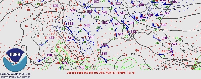
-
Texas 2025 Discussion/Observations
Stx_Thunder replied to Stx_Thunder's topic in Central/Western States
Not seeing any real thermal differences and I trust the 12z runs more from experience. 850Mb 0 C line is still way too close over DFW for all-snow comfort until later Thursday night. Should also note 700Mb 0 C line also still quite close on both runs as well. -
Texas 2025 Discussion/Observations
Stx_Thunder replied to Stx_Thunder's topic in Central/Western States
Both today's 12z GFS & Euro trending on a slower approach of the H5 Low out west and consistently still quite potent & large. This could easily allow for longer/deeper low-level WAA over the eastern part of state as the Gulf Low is likely to track more northward up the coast instead of offshore. With a fairly strong southerly LLJ (possibly 50 knots in STX which is definitely plausible in this scenario but could be even stronger as I've seen in past years, this time of year). While not likely, it's definitely worth noting Canadian wants to bring the 850Mb Gulf circulation further inland over ETX Thursday night on today's 12z run. WPC now even has a marginal excessive rainfall risk posted for mid-upper coast for possible 3 - 5 in. rain totals Thursday - Friday morning (Day 3). Which would 100% be above normal for this time of year in such short duration. --- 850Mb temp even now on DFW 0z UA obs this evening is only around -2 C (-3 this morning) per SPC data with above freezing values not well south either. All in all, it's pretty safe to say now it will not be an all-snow event in DFW. Moisture should not be an issue around there in this scenario with the large-scale and fairly deep WAA regime over the eastern part of state. And it's definitely keeping my eyes pinned on that up north way more than the coastal & possibly even up to ETX heavy rainfall threat (again there) around me. Even thunder potential over all coastal region which SPC noting on D3 outlook. Which I wouldn't rule out a supercell or two near the upper coast with 60s DPs coming right next to the coast (even upper 60s not far offshore) on both GFS & Euro, with such a very dynamic system out west. Which I still don't think many here realize. -
MO/KS/AR/OK 2024-2025 Winter Discussion
Stx_Thunder replied to JoMo's topic in Central/Western States
Saw FZRA icing accumulation this past weekend was actually 0.50 - 0.75 inches in southeastern MO (St Louis NWS) storm report near Chloride. Just like the GFS painted there last week. A 2.5" Sleet LSR somewhere in that region as well, but there was snow mixed in many of those sleet reports. Things are trending less snow and potentially more icing over Eastern TX because of projected warmer LLs, but possibly a dismal rain only. Even in the Dallas-Fort Worth area. -
Texas 2025 Discussion/Observations
Stx_Thunder replied to Stx_Thunder's topic in Central/Western States
That'd be very interesting as well like I kind of got here back in 2021 TX chill. 'Wasn't an actual sleet storm around here in STX, but still lasted a couple hours & the most I had ever seen from my own eyes. I've already seen all snow a couple times and in other places out there. Freezing rain with icing accu. only once. All of which are pretty rare down here. It would be even more interesting if all winter precip types actually happen in DFW this time around. Which there is that possibility in the cards as well. -
Texas 2025 Discussion/Observations
Stx_Thunder replied to Stx_Thunder's topic in Central/Western States
With the projected southeast LL flow on all the main globals all the way north to DFW, there is definitely that chance it could end up being mostly rain (which I kind of hope not and gets a good icing event at least), with such sig Gulf-influenced WAA pattern. Maybe not initially because of dry/cool LL environment at first, but the warm-rain processes would eventually force it to go all non-freezing rain if much of the lower column does go above freezing. It's a pretty complex winter wx forecasting scenario this time around which makes this a heck of a lot of more interesting to watch around DFW this week. It's very important to note though, that more southeasterly LL flow (instead of southwest). I haven't seen a winter wx scenario like this in NTX with that kind of flow from what I've seen over the years. If it was more southwest (like I'm sure it is most of the time up there in winter wx scenarios), then all the NTX or DFW area snow addicts on here would likely be jumping by now.. -
At this point in DFW and south into C/ETX seeing all the newest data output today, it's looking more like a messy (interesting) all types winter precip setup later this week. H5 temps may be cold enough for all snow in NTX with the incoming SS Low out west. But I've been seeing the globals (including Euro) being fairly consistent the last couple days on 850Mb and even H7 temps, merely staying around 0 C (if not potentially warmer) for most of the active period with such an unusually broad Gulf low influencing a fairly deep southeasterly LL flow over the Eastern half of state. Which would likely cause some sig LL warming even into DFW area at least to an extent.

