
Stx_Thunder
-
Posts
312 -
Joined
About Stx_Thunder

Recent Profile Visitors


-

Texas 2025 Discussion/Observations
Stx_Thunder replied to Stx_Thunder's topic in Central/Western States
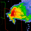
Fine TX spring wx all this week to be outside. Can't ask for more comfortable conditions in the entire state by this time of year. Was more winterlike this past weekend even in STX with below normal temps. And record snowfall in the Panhandle region.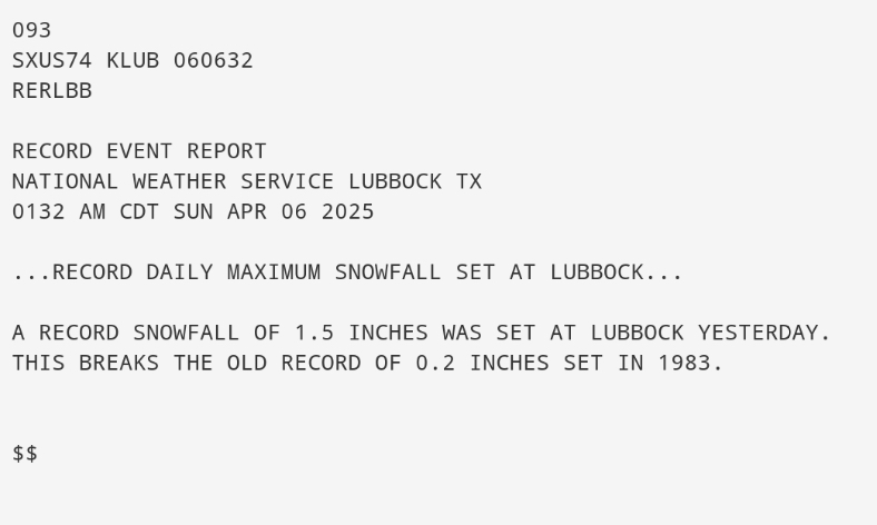
-
Texas 2025 Discussion/Observations
Stx_Thunder replied to Stx_Thunder's topic in Central/Western States
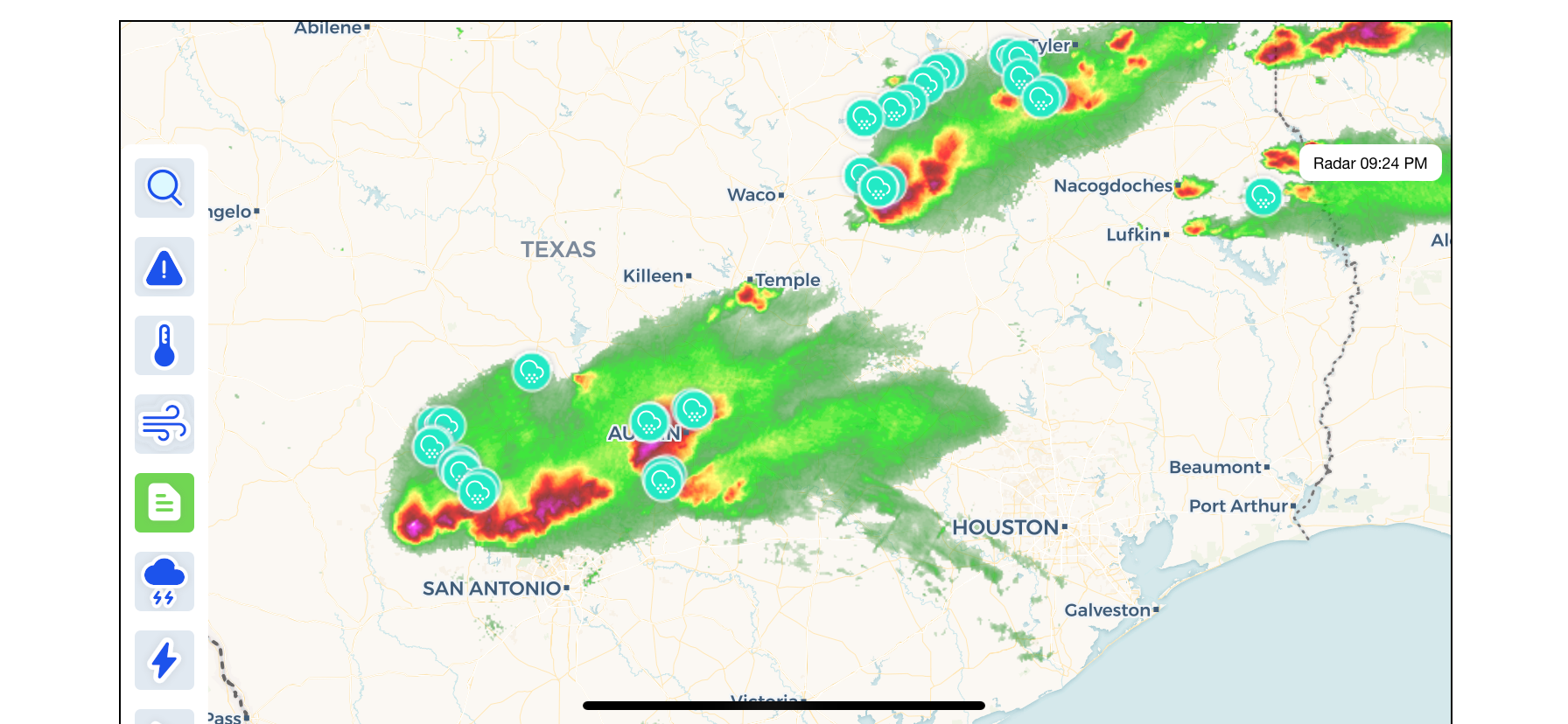
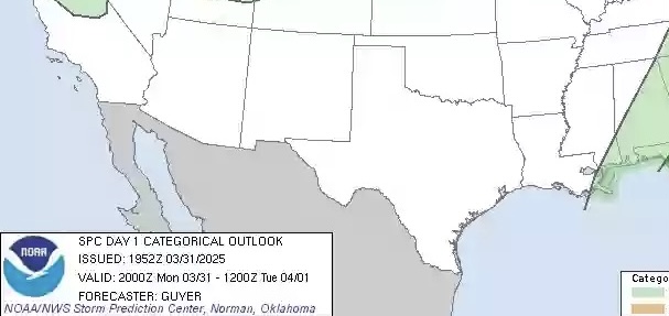
SPC, 100% dropped the ball today here in TX.. 2 in. hail reported in San Antonio at sea world, from a storm that literally popped up right over the city 2 hours ago with a front/dryline in the area and obviously a shortwave trailing east-southeast in the w/nw upper flow aloft (looking at this evening's obs sounding data). Causing a few other cells right now in STX.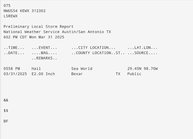
-
Texas 2025 Discussion/Observations
Stx_Thunder replied to Stx_Thunder's topic in Central/Western States
Some recap on the easily historical RGV flooding this week: https://www.krgv.com/news/hundreds-of-water-rescues-made-in-cameron-county-more-underway https://www.valleycentral.com/news/local-news/harlingen-streets-flooded-residents-rescued/ The airport in Harlingen (Valley International) is closed at least until Monday. -
Texas 2025 Discussion/Observations
Stx_Thunder replied to Stx_Thunder's topic in Central/Western States
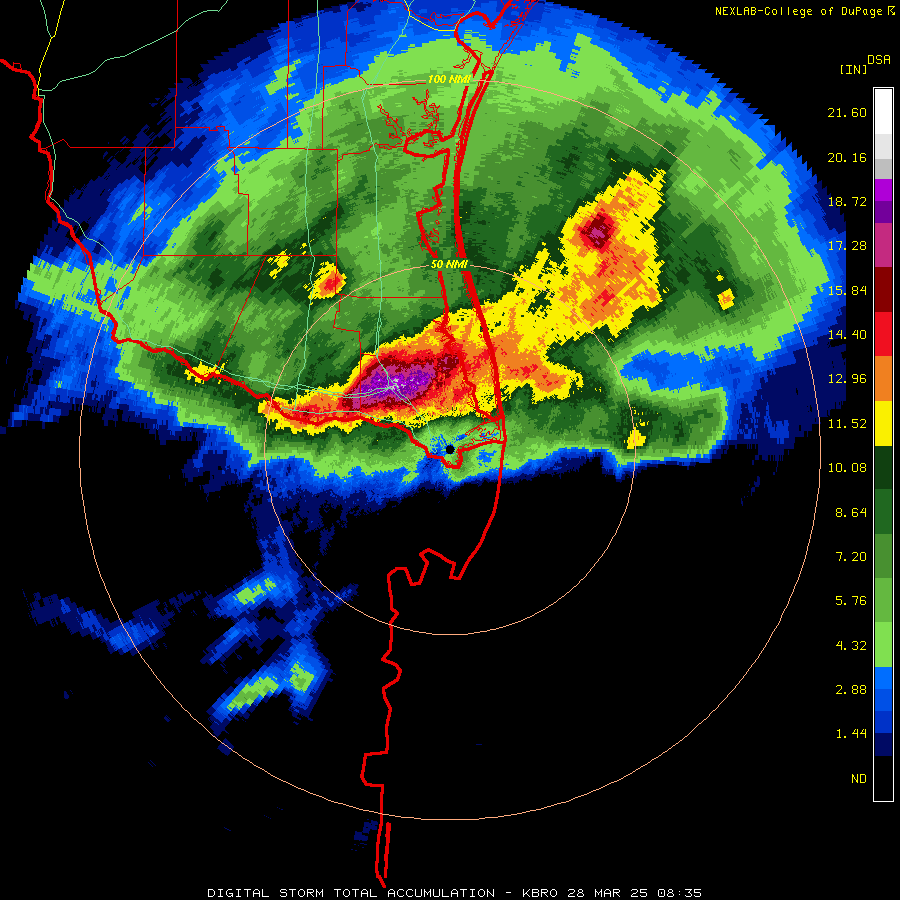
Deep STX / lower RGV is the clear winner in the convective pattern this week. Many severe warnings were posted throughout a 12-hour period starting around noon Thursday, all the way until about an hour and a half ago. One convective cluster/segment after another, moving at a turtle pace east along the Rio Grande to the coast along a stationary front. Extremely impressive storm totals in & around Harlingen (just up the road from Brownsville). Now going up to 20 inches since Wednesday afternoon! (26th)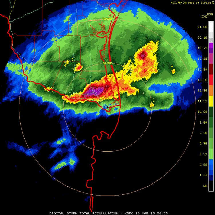
-
Texas 2025 Discussion/Observations
Stx_Thunder replied to Stx_Thunder's topic in Central/Western States
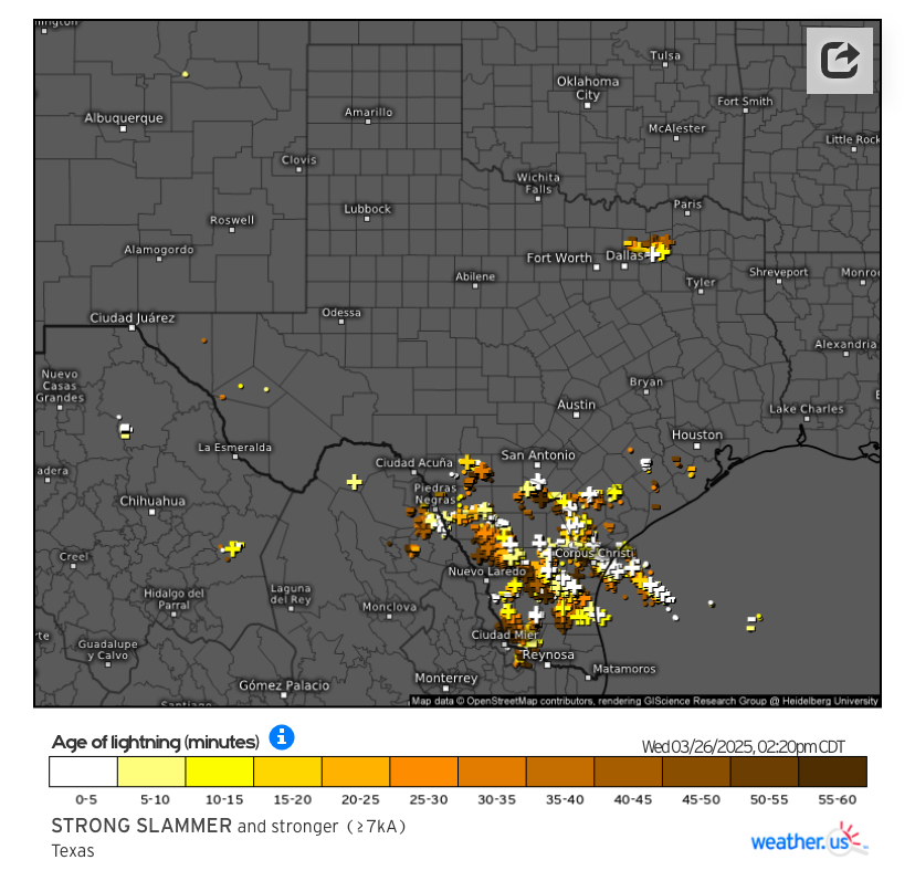
Finally hearing thunder again and things lighting up over the southern part of state. Good amount of +CG strikes despite it only being *just the very beginning (initial weak shortwave) of a multi-round thunder show through Friday. Convective pattern I like the most. Not sure if I can agree on WPC's decision to post 'moderate' excessive rainfall risk through tomorrow in D1 & 2 outlooks. I do like that they wrote out the "worse" and "best" case scenarios yesterday in the discussions. But there'll likely be some runoff issues in STX especially considering how long & dry it's been since the last heavy rainfall several months ago. Both Euro & GFS insistent on near 10" totals swath somewhere between San Antonio and Corpus by the weekend. Brownsville (BRO) 12z upper air obs was already showing 1.7 in. precipitable water this morning. And southeasterly flow even above H7. So it looks like 2" PW could be reached later tonight or tomorrow. Which would be getting into record territory for this time of year.
-
Texas 2025 Discussion/Observations
Stx_Thunder replied to Stx_Thunder's topic in Central/Western States
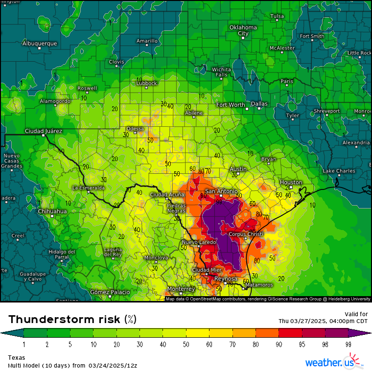
'Have not seen forecast thunder probs like this over the southern half since last September.. Max rainfall totals still up in the air as models are starting to slow down the approach of the Low/trough (more cutoff-like). Both Euro & GFS having convective feedback issues today showing around 10" bullseyes, but the slowdown would likely allow PW to climb higher near the coast and both are showing up to 2 in. now. Which would be well above normal this early in the year.
-
Texas 2025 Discussion/Observations
Stx_Thunder replied to Stx_Thunder's topic in Central/Western States
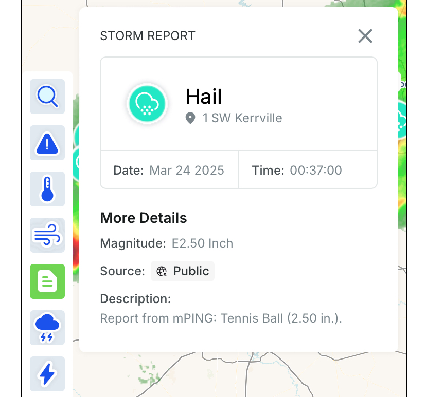
Decent amount of hailstorms and clustering going on this evening with a front in CTX. Wasn't expecting that with the limited CAPE and moisture. And pretty high CIN on upper air obs earlier today. Especially the 2+ in. hail in Austin/San Antonio area.

-
Texas 2025 Discussion/Observations
Stx_Thunder replied to Stx_Thunder's topic in Central/Western States
Looks pretty good for at least some convective action finally returning for not just the northern half, but southern half of state also later this coming week. The MJO edging back toward the latter phases and definitely diminishing LN in progress also gives hope. GFS, Euro and ensembles are kind of wobbling around over the state on highest rainfall totals. But with the more unusual southern Low/trough consensus track projected in NE Mex, would obviously expect the better action over the southern half this time. Particularly closer to the Rio Grande and Alamo city (SAT) region. Where they literally need it the most in the entire state. Not sold yet on those 3+ in. totals Euro and ensembles been showing the past few days with PW only projected around 1.5 in. or so, and still in March. -
Stx_Thunder changed their profile photo
-
Texas 2025 Discussion/Observations
Stx_Thunder replied to Stx_Thunder's topic in Central/Western States
Looks like another very highly volatile fire weather setup today (Wednesday) behind this morning's front moving through the state. Del Rio dew point is already coming in at < 0 F at 6 am obs with a sudden rise in post-frontal temp during the past few hours even though it's still night (along with blowing dust). I have seen this kind of post-frontal outflow or cold front warming phenomena written in NWS area forecast discussion before but don't recall the term for the process. - Fredericksburg, 'Crabapple' big wildfire that started on Saturday (15th) and has burned just under 10,000 acres total, is now 90% contained looking at data and reports from Tuesday evening: https://www.kvue.com/article/news/local/fredericksburg-texas-crabapple-fire/269-90fa3522-9149-4b66-8b63-90e2febddc2e Hopefully it's fully contained by early today. As this afternoon's sun and warmth with extremely dry and gusty post-frontal north/west flow air and steadily worsening drought is going to make things no doubt highly conducive for wildfire growth & maintenance (looks pretty similar to March 4th afternoon post-frontal setup). -
Texas 2025 Discussion/Observations
Stx_Thunder replied to Stx_Thunder's topic in Central/Western States
Lubbock reported peak post-frontal wind gust of 82 mph, with brownout and near 0 visibility in the ongoing Panhandle region dust storm. Good amount of non-convective wind damage reports around there today also. - - - DFW also reporting blowing dust (though winds nowhere as strong as they are out west). I didn't think the high wind warning was warranted for DFW area earlier today. Seeing the position of the deep Low ejecting further north over the C Plains and LL momentum even this afternoon over DFW (despite temps in the 80s) is still pretty weak on radar VWP. Dryline heat spike this afternoon with temps well in the 100s in STX with Cotulla topping 105 F. Though not unheard of this early in the year in March.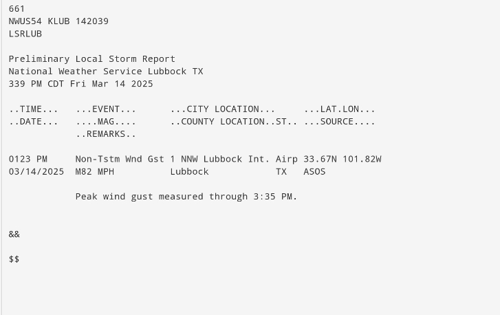
-
Plains States Observations and Discussion Thread
Stx_Thunder replied to lookingnorth's topic in Central/Western States
https://www.spc.noaa.gov/products/fire_wx/overview.html - Lots of Fire wx potential the next several days across the S Plains. Even a rare, (dry) thunderstorm potential around the KS/MO border region tomorrow (14th). SPC going with another 'Extreme' risk area (like on March 4th). Amid very low sfc dew points to potentially < 0 F on Euro, strong/very strong winds, and warm temps.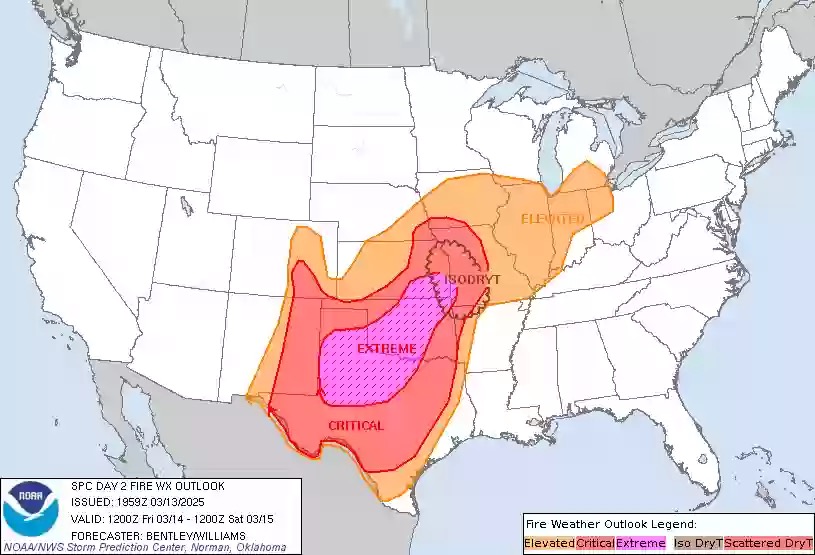
-
Texas 2025 Discussion/Observations
Stx_Thunder replied to Stx_Thunder's topic in Central/Western States
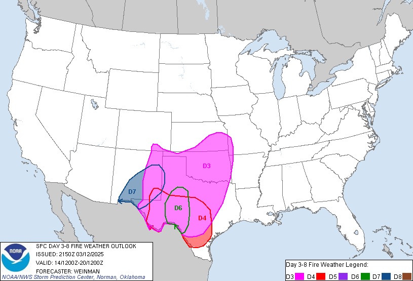
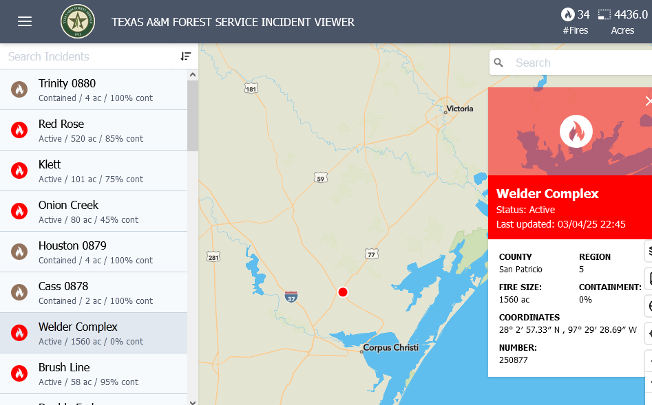
https://www.kristv.com/news/local-news/in-your-neighborhood/san-patricio-county/sinton/sinton-fires-investigators-determine-what-started-tuesdays-devastating-fires https://www.kristv.com/news/local-news/in-your-neighborhood/san-patricio-county/sinton/sinton-neighbors-return-to-the-aftermath-of-the-devastating-fires - Recap of Tuesday's wildfire aftermath in Sinton. Multiple wildfires started in San Patricio county Tuesday afternoon. Which is likely why the A&M fire incident data was overestimating the burn acreage of the 'Welder' fire alone. Although another fire (Railway) not far from it on the northeast outskirts of Sinton did burn over 700 acres total. ArcGIS data also shows this. Despite its confirmed small size (<100 acres), all it took for the Welder fire to become disastrous & completely burn down 17 homes in Sinton, was a simple downed power line. Combined with strong post-frontal winds, extremely dry air (DP around 10 F), ongoing drought/cured vegetation fuels, and very warm temps in the 80s/90s last Tuesday afternoon. - - - The fire wx danger over the western half of state does not look to end anytime very soon. SPC is already highlighting Critical fire wx risk areas in the D 4-8 outlook as the fire threat could really escalate again behind another deep Low traversing the Plains at the end of this new week (14th - 15th). And may even need to be expanded further northeast closer to DFW region and into the C Plains. https://www.spc.noaa.gov/products/exper/fire_wx/ - Also, the ongoing drought in the state is obviously worsening with San Antonio area now in a developing 'Exceptional' (D4; max drought intensity) status. https://droughtmonitor.unl.edu/CurrentMap/StateDroughtMonitor.aspx?South -
Texas 2025 Discussion/Observations
Stx_Thunder replied to Stx_Thunder's topic in Central/Western States
A large brushfire (Welder Complex) burned just over 1500 acres total in San Patricio county on the northeast side of Sinton where evacuations of several hundred people occurred Tuesday afternoon (biggest town in the county outside of Corpus area). It seems to be fully contained now late tonight looking at local media updates from Tuesday evening. Especially now that winds have died off and DPs have recovered, but did burn structures down (20 houses but damage extent still not clear). This was the largest active fire reported in the state on Tuesday. - - - Mesonet site in Val Verde county (Del Rio area) around noon Tuesday reported 67 mph post-frontal wind gust. Highest non-convective gust recorded in the Austin/SAT NWS region on latest LSR data.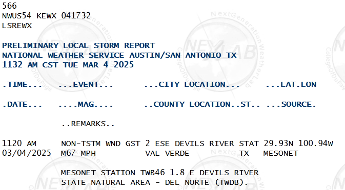
-
Texas 2025 Discussion/Observations
Stx_Thunder replied to Stx_Thunder's topic in Central/Western States
Very impressive dew point drops behind today's system & dryline to < 0 F in the Rio Grande plains and even < 10 F near the coastal bend with very warm & strong post-frontal westerly downslope flow component (Cotulla is sitting at -4 F right now at 3 pm obs). Del Rio had post-frontal wind gusts to 60 mph earlier also. The wind is howling this afternoon in the southern half of state with all the very warm afternoon air transferring more of all this post-frontal momentum aloft down to the surface. DP was at 0 F in El Paso yesterday afternoon with blowing dust in W/NWTX. I can see the dust is around here in STX causing haze this afternoon but that could also be because of an active wildfire ongoing in Duval county blowing the smoke east. No disagreement at all on SPC's decision yesterday to post a rare 'Extreme' fire risk outlook area over the southwestern half of state for today. Considering how dry both the air & ground are in that region (along with the warm, strong west downslope flow). Although no major active wildfires have broken out looking at TX wildfire map data as of typing this. -
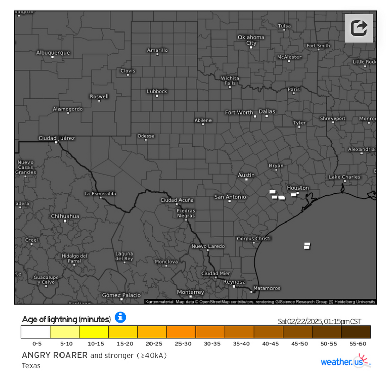
Texas 2025 Discussion/Observations
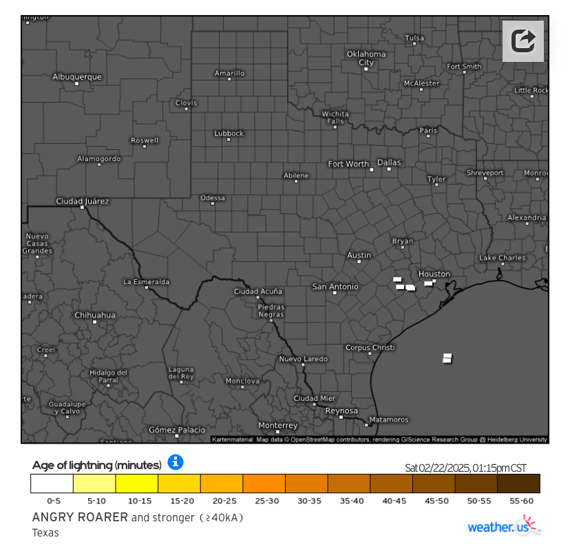
Stx_Thunder replied to Stx_Thunder's topic in Central/Western States
'Meant to post this last night after looking at latest evening model data, but with the modification process of the (extremely shallow) arctic origin airmass well underway just above it in the LLs around the coast, elevated storms have broken out today around Houston with some already stronger lightning strikes as of typing this. Corpus (CRP) 12z upper air obs this morning already showing effective shear near 60 knots, and steep ML lapse rates above 7 C. Fairly strong LL south warm-air advection flow, and cold H5 temps below -15 C. Even though SPC is thinking the hail threat is lower today & tonight on D1 outlook discussion (probably because of latest mesoscale model data this morning keeping everything offshore), the models are underdoing the deep convective threat today, onshore. Especially the already ongoing Houston area storms. So I don't think the severe hail potential is nonexistent. Especially tonight as Euro has been fairly consistent showing a decent amount of MUCAPE (>500) hanging over the mid-upper coastal region with weakening CIN. Ahead of a stronger, more pronounced H7 shortwave moving into the state from the west (both on Euro & GFS).