.jpg.60032c348ffbfe96450212c98c077602.jpg)
vortexse93
-
Posts
49 -
Joined
-
Last visited
Content Type
Profiles
Blogs
Forums
American Weather
Media Demo
Store
Gallery
Everything posted by vortexse93
-
What makes you think that with the MJO?
-
Quite possibly, but the AO is expected to be negative as well in this time frame and us being in Feb into early March has me concern that the cold arctic airmass could contaminate some of the other teleconnections and mess up the pattern. I’m not saying it will or will not, I am just saying it is something to watch for going into March. I do like the MJO and ENSO phase we are in or trending towards. Maybe a strong enough MJO in the right phase could off set the AO but time will tell. Also have to see the NAO and PNA as both weren’t in good phases either but it only takes one to make or break a forecast. For now, have my eyes set for Saturday and will get back to the MAM after this week.
-
Continuing to watch for a potential chase day towards the mid to late Feb. As of right now, the CFS is continuing to show the potential for convective storms towards the middle of the month, potentially towards the end of the month. For temps, long range models are continuing to show above avg temps between Day 8 to Day 14. Anything after Day 15 temps begin to return to normal before another shot of cold arctic airmass returns to the region by the start of March. If this is true, the cold arctic airmass could delay the start to the spring season for portions of the country. While this is not set in stone, it is something to consider going forward and picking out potential chase days and/or weeks going into March (will be another discussion for another day). The real question of the next couple of weeks will the teleconnections be aligned to help better the chances? At this moment, it is hard to say as several of the teleconnections will be out of the phase to help support or even enhance the chances of a favorable storm track. Will have to continue to watch and monitor the models over the next several days and see how things play out. If Feb. decides to be bust this year, I will begin to focus on the MAM to AMJ timeframe. There is nothing guarantee of course, this is me just looking forward to the 2025 Spring Season and hoping to get a little tease before peak season gets here.


-
It seems like it could be one of those mini supercell days from the wording and the low CAPE environment.
-
Will keep this short, want to save the good stuff for MAM or try to at least. The CFS is continuing to show potential for a mid to even late Feb severe weather potential. Some of the things I do like is the ridge off of the Appalachian Mountains seems to be weakening, this is based on both the CFS and the recent EURO weeklies (not shown here) However, the NAO does remain positive well into this same time frame. Can the AAM get into a favorable phase as well, it is possible, but will it stay there is another question. At least for now, it is something to watch for still going into the month of Feb. I am liking what I am seeing with above abv temps in the long range along with some troughness out of both the CFS and the EURO weeklies towards the Rockies and Central Plains. Will like the NAO to be negative, as it gives a better opportunity for troughs to dig a little deeper south but one can only hope at this stage. It is a very much see and wait type situation at the moment. But seeing the model guidance trends, mid to late Feb could provide a teaser into what MAM could have in store for us.

-
Well, if this comes to fruition, my forecast would bust oh well.
-
To be fair with last year’s ENSO, we were in an El Niño going into a La Niña. Historically, El Niños tend to have less active tornado season across the Southeast as a whole. When we made the switch to La Niña, it was a little late for the Southeast if I do recall correctly. That’s why I am a little excited about this season since we are in a La Niña maybe it will give more opportunities to chase. Now this will be dependent on the other teleconnections including the AO, MJO, PNA and the NAO.
-
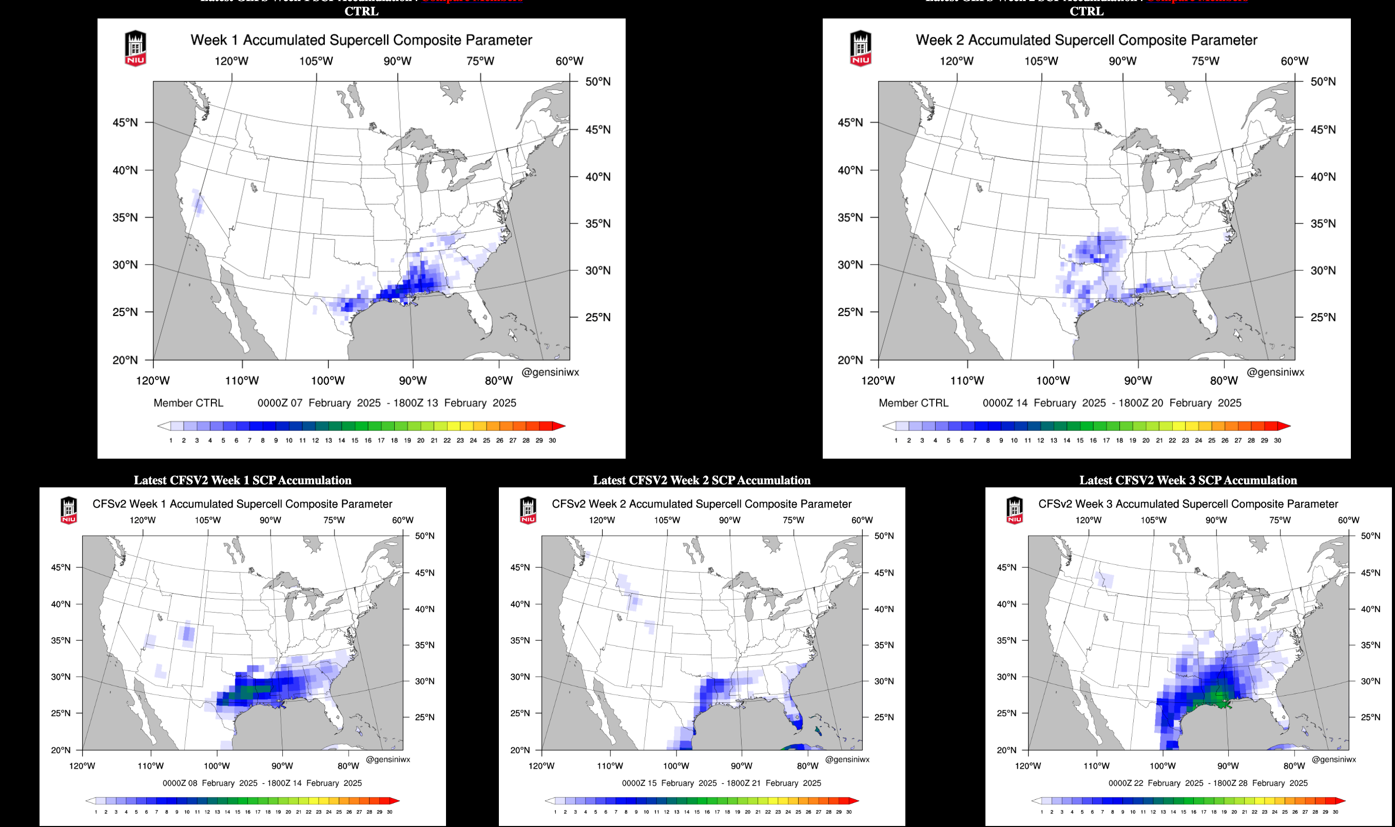
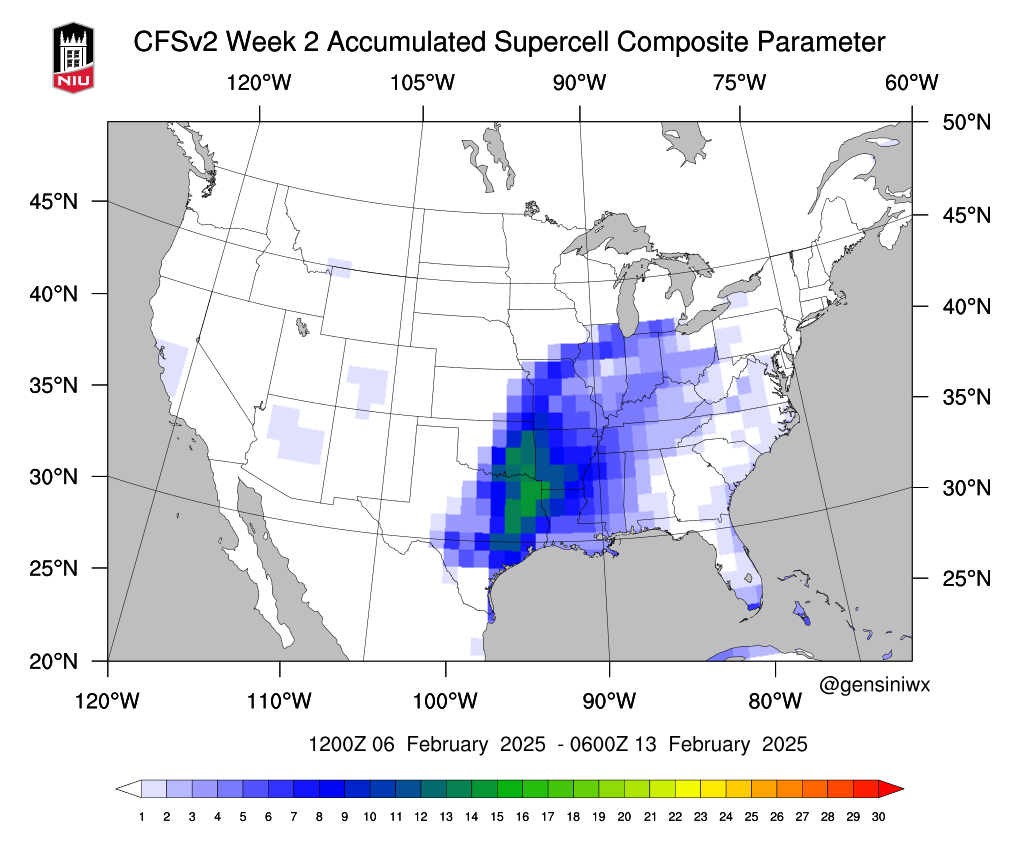
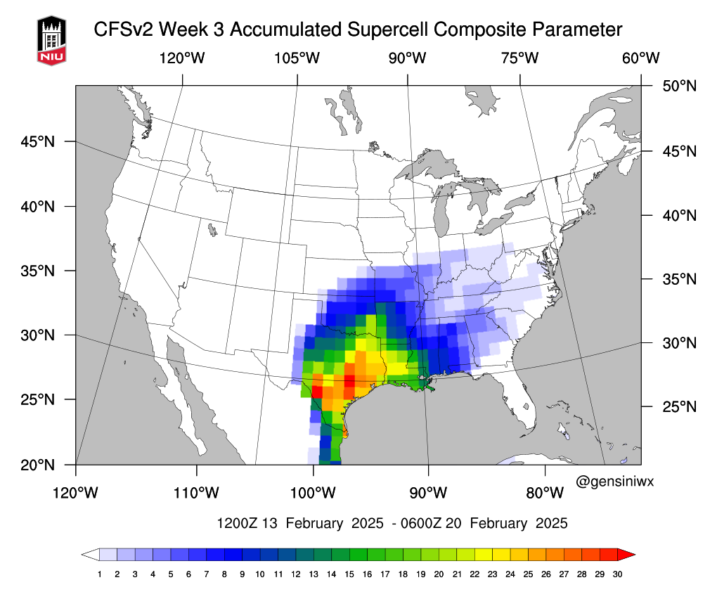
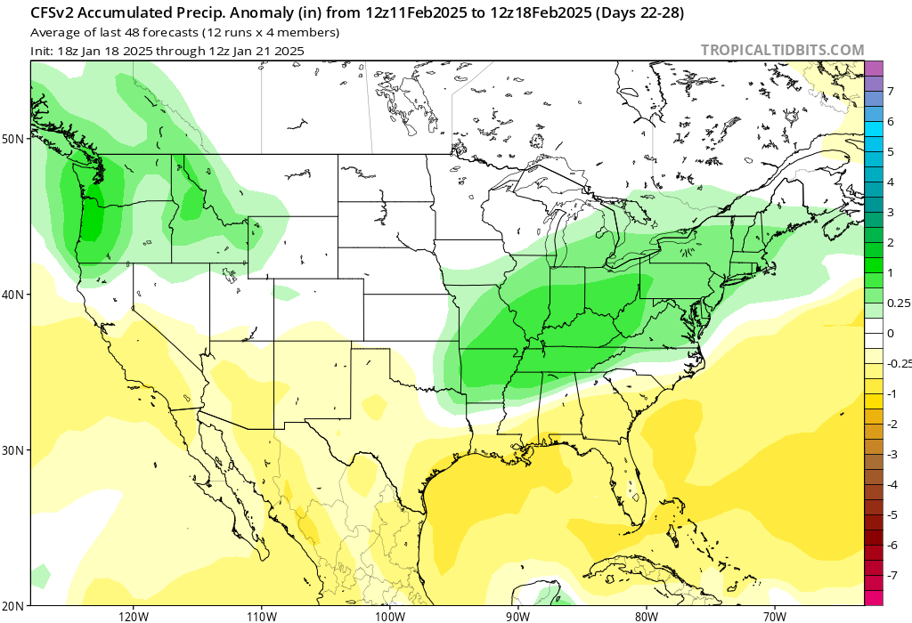
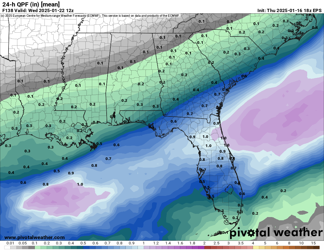
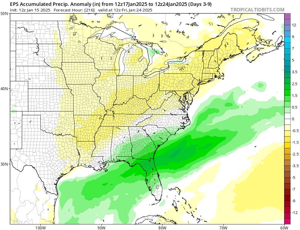
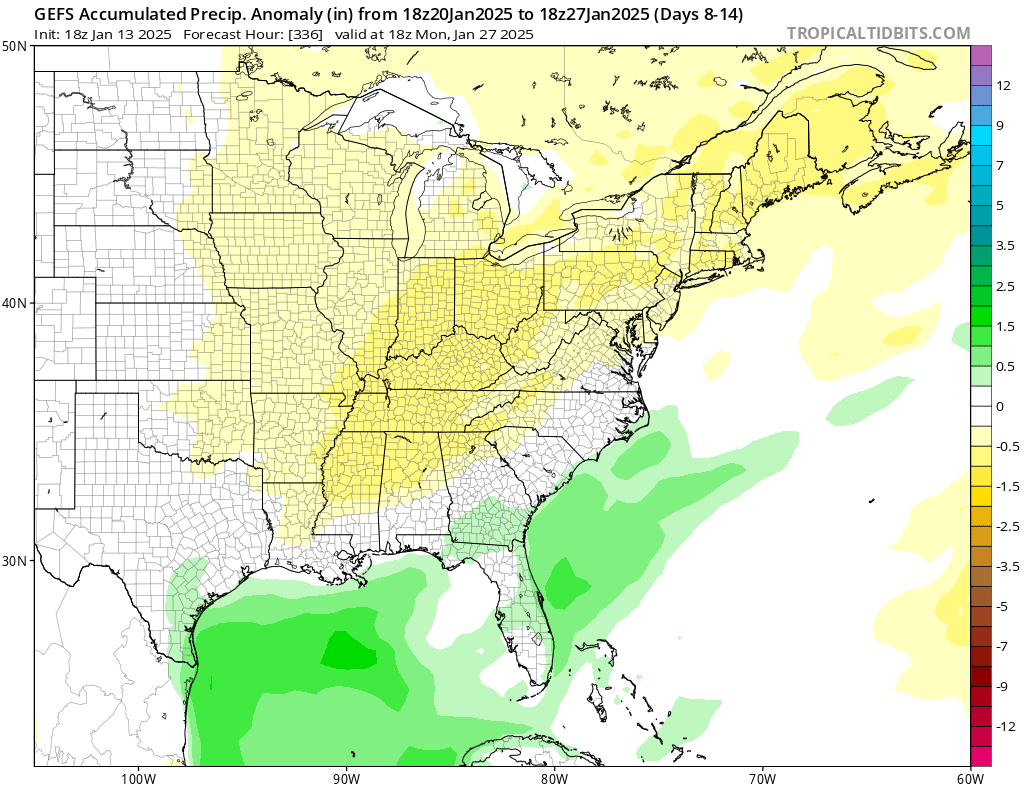
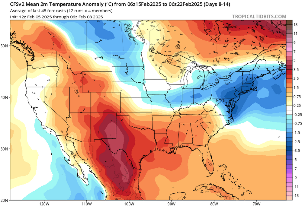
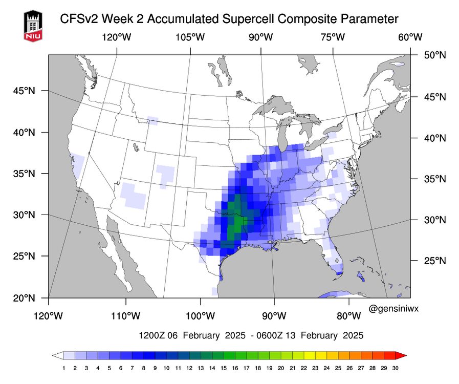
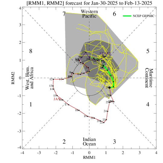
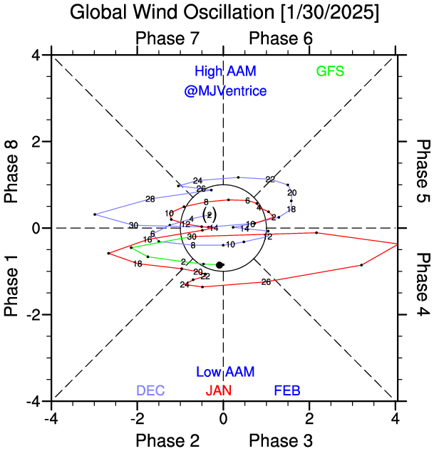
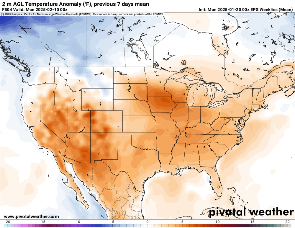
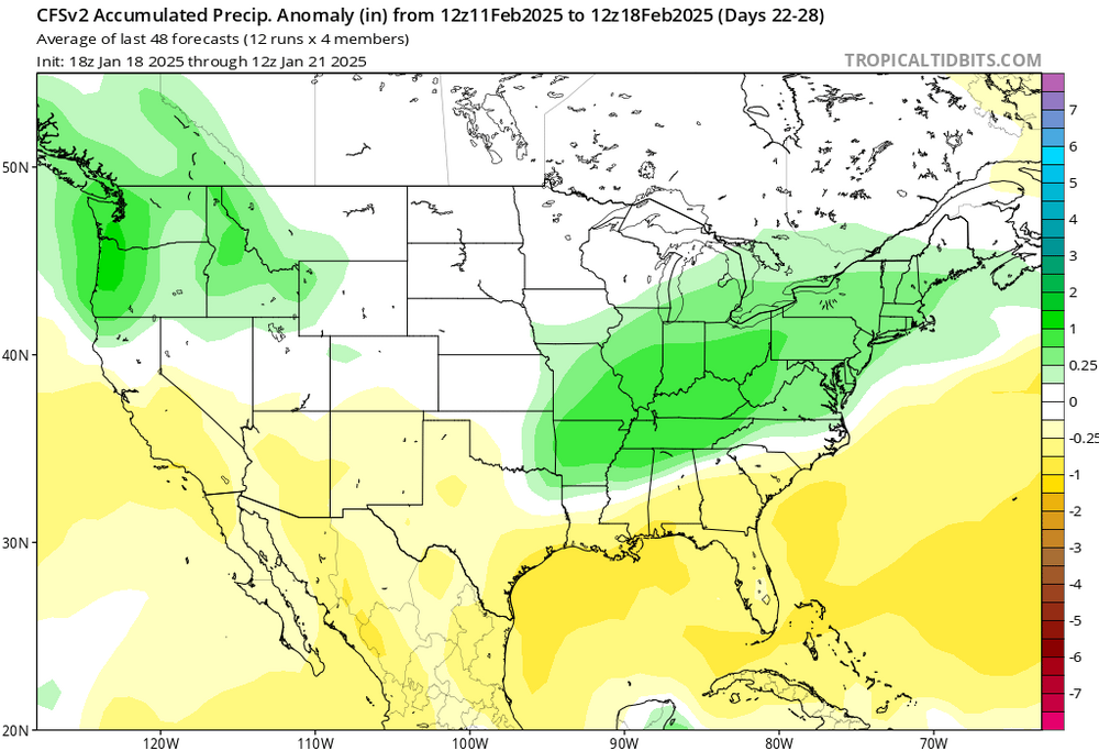
Please reference the figures above for this discussion. While I would typically wait and do this type of sub-seasonal forecast for the months of MAM, some of the data in the CFS and the EURO Weeklies caught my attention and wanted to at least discussed the small window that could make Feb very interesting. Starting off with temp anomalies, both the CFS and EURO weeklies are showing above avg temps for a large portion of the Southeast US by the middle of the month along with above avg precip over the Lower Ohio River Valley into the Upper MS River Valley during this time span. This also evident in the CPC Outlook (not shown) for the month of Feb which speaks volume to what the models are showing at this time. While temp and precip anomalies themselves can not predict or give the proper insight into convective forecasting, the mere fact of them overlapping each other within the same time frame does suggest there is a window of opportunity there. As for sfc features, the CFS is not quite sold on a sfc low being in the right place at the right time, but does in fact show a possibility of one. If timing and placement of the sfc Low is right, then there is a quite possible that we could see convective storms around the middle of month across the Southeast US which would include, TN, AR, MS, and AL. Something to consider in all of this are the teleconnections and their role into making this happen. With the MJO, while it does perform better during the spring time months, there is still good possibility that it will be in favorable phase to amplify the subtropical jet by the time we get into mid-Feb. Timing of this will be extremely important as temps should be well above avg and could give the proper set or at least on the grand scheme of things. As for ENSO (while not shown), it is too in a favorable phase for tornado activity in the month of Feb and should remain in La Nina for quite some time as we head into MAM time frame (another discussion down the line). Despite the recent arctic airmass across the Deep South, the airmass should be able to recover as suggested in the long range and climate models. The AO should be back into a positive phase during this time which should also help the airmass recover. How long will the AO stay in the positive phase is another question in itself. This recovery from the recent arctic blast will need to be watch as we head into the month of Feb. While model guidance is trending towards above avg temps, it would be a matter by how much and when. Any more arctic airmass blast could closed the window on any convective storm potential around mid-Feb, which is why it is so important to keep on this from now on. While we are several weeks out from this, I think personally the window for convective storms around mid-February is possible, especially if the climate and long range model guidance continues show above avg temps and preicp in the region along with the proper synoptic-scale features in place. Main thing to keep in mind will be the MJO phase and the AO phase. I have read and looked into the AAM teleconnection, unfortunately the time scale is way out of reach for this particular teleconnection, but it is something to check on towards the end of Jan into the first week of Feb. Right now, the middle of Feb has my attention and will see how it goes from here. Since I am still new on here, in no way that I am saying that there will be convective storms, I just think that the window is there, especially with the temps, precip and with some of the teleconnections at play and from what I have seen. I am also interested to see feedback and others think about mid-Feb.
-
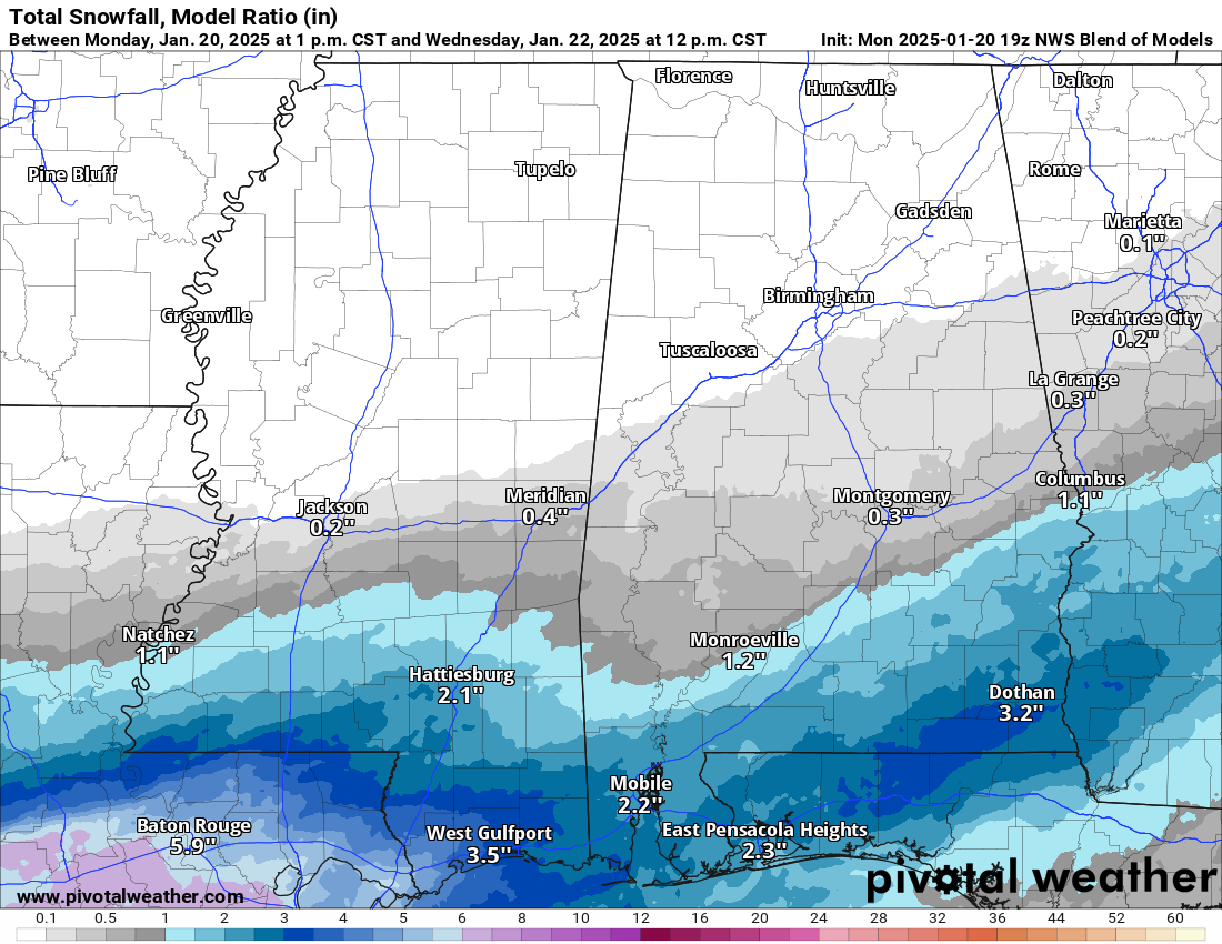
This post will likely be the last for this event and will also be on the shorter side of things as well. It appears for much of Central MS will end up on the drier side of this system. This is what I was concern with from the start as some of you may recall from my previous posts. This is now apparent in all the forecast model guidance. For those along I-20 and north (including the Jackson Metro) will likely see very little of snow, if that. There is not enough precip to overcome the dry airmass and so this will result in very minor snowfall accumulations. For those in southern MS to the MS Coast, snowfall accumulations are not only likely but could be significant in some places. Widespread snowfall totals of 2 to 4 inches will be possible, while some areas could be pushing closer to 6 or even 8 inches of snow. The higher snowfall accumulations will be very dependent upon where the heavier snow bands will end up at and their duration of those bands.

-
Appreciate the links. I did read the AAM one and it was very interesting and makes more sense on the by certain phases favor tornado seasons. Also, if you haven’t checked it out, ENSO looks to stay in a La Niña phase for much of the early part of the spring according to the EURO so something to watch for in combination with the AAM.
-
This would do for the AAM. Do you by chance have anything on MJO as well? Pending tomorrow's winter storm, might need something to pass the time tomorrow.
-
So is it too late to say I already got one funnel and one wall cloud in Dixie this month out in the MS Delta?
-
Can you go into more detail how this and MJO helps with tornadoes along which phases are prone an active tornado season? I typically use ENSO as it is the one I am more familiar with and understand the most.
-
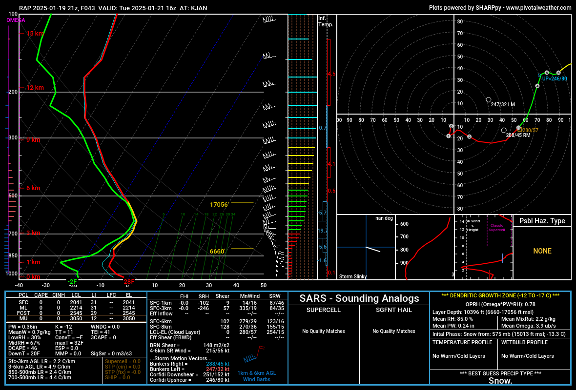
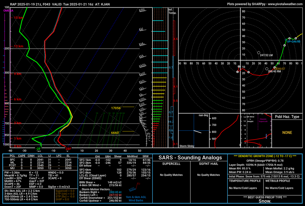
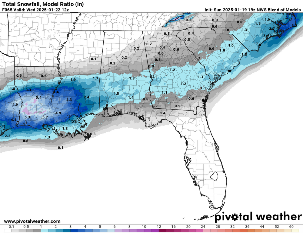
This is not my final snowfall forecast, but in a close enough time frame to go into some detail of my concerns with this system. For starters, long range model guidance have been indicating for a rare winter storm to impact LA into South MS for about a week or so and this is still consistent with the medium and short range models as of recent. For Central MS, it remains very uncertain on if there will be enough precip to overcome the extremely dry airmass. While model guidance of the ensembles are still indicating snow, the medium and short range models are not so certain that will be the case. The NAM, HRRR and RAP are suggest otherwise. The forecast sounding for KJAN from the 21z sounding does show a moist environment in the mid levels, but from about 700 mb down to the sfc shows a very dry environment. This concerns because this type of sounding is not supportive of snowfall, but instead snow flurries and very minor snowfall accumulations for Central MS. As some may recall in a previous post on here, I had concerns that Central MS will end up on the drier side of this system and based on the medium range guidance, this still could be the case heading into Tuesday. There is some time between and Tuesday for this system to make a push further north that maybe some of precip can make enough of an impact, but time will tell on that. The NWS Blend and several of the ensemble data are still indicating for potential snowfall of 1" to 2" across Central MS. However, given the time frame, I tend to lean towards the short range model guidance, especially with the census of those short term model guidance showing dry air eating away at any potential moisture in the atmosphere. Will still continue watching over the next several hours to see how this system will progress throughout the course of the day. Pending what tomorrow shows, will likely determine how Tuesday will pan out.
-
My two cents are La Nina years = Dixie Alley and thats it. I am still trying to figure MJO patterns with tornado frequency but keep this on tabs for when we hit Feb.
-
Just wait until March April and May for severe weather. Have a sneaky feeling it could be active for good ole' Dixie Alley.
-
I am going to bring this topic back to next week as this is more on my mind than Feb stuff at the moment, sorry guys. 18z EURO and even the 18z GFS appears to have some agreement with the 12z and even 18z ICON model runs. As for the Canadian, the 12z run has the sfc Low in the right location, however, I think it is being way over aggressive with the snowfall and the coverage with the wintry precip at the moment. As for the GFS and EURO ensembles, they are slowly coming in line with the Canadian and ICON models, but still are being persistent with the dry air over Central MS. The current ensemble runs of both the GFS and the EURO has increased confidence in seeing 1 inch snowfall across the region this afternoon along with increase QPF across Central MS. The 18z ICON appears to have severely cut back the coverage of the wintry precip at fcst hr 120, but will have to wait and see how it handles it tomorrow. Also will be curious to know if the GFS will start coming back to reality some as well tomorrow as it day with the 18z run today. For those in southern MS, my concern focus towards the sleet/freezing rain potential. While model guidance does not show any warm nose present in the 925 mb to 850 mb range, the freezing line does hug the coast a little more than I like. Current WPC guidance does not show a big chance for freezing rain at the moment for next week, however, model guidance is showing the possibility for it. Will need to watch that carefully as well. At this time, it is appearing to that this could be a matter who sees what in terms of wintry precip and how much. I think it is way to early to get into snowfall or even ice accumulations. It does appear that confidence within the model guidance is increasing which should hopefully continue into to the next few days.

-
That is true, but I also know that drier snow equals to lower snow ratios as well. If that Low can shift just right, could very well see snow in Central MS, but I am not just not completely sold on it. I should have added the QPF totals as it was showing the cut off of the precip right at Central MS. I am still watching the system but not getting excited by what I have seen. Might also have to watch for temps in the 925 to 700 mb range in case warm area over runs the front and then it some of the precip could be sleet/freezing rain event. I think there is a lot of uncertainty for Central MS at the moment in what will happen but it looks like the other areas I have mentioned are going to be the main focus for this event. Will have to see what happens.
-
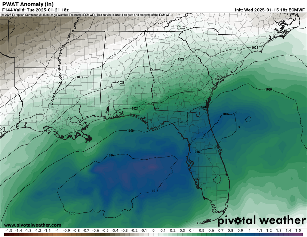
I know I have used this graphic before, but when looking at the operational runs of the models, especially the EURO and EURO-AI the trend shows Central MS into TN being on the drier side. For reference, the PWAT anomaly is also posted and they almost overlapped perfectly at this stage of the game. The main concerns that the models are focusing on will be the southern AL/GA/FL and possibility SC. Not sure what the GFS is doing at the moment as it looks to be the odd man out. If the trends continue to go this route, could see a historic winter event across the Deep South. All of this is based on location of the sfc Low, timing of both the precip and temp. I think by this weekend we will have better idea and hopefully the models get their act together as well. I am also really conservative when it comes to winter weather it is one of the most difficult things to forecast and it takes 1 deg to make a difference between precip type. But given the data at hand, if I am along the coast, I would be watching this system very closely. I am just not sure how far north the winter precip will extend. I think that is where the uncertainty is at in all of this.

-
Looking into the long range and appears the cold streak maybe even an outbreak over the Deep South around the 20th to the 30th of Jan. This is obviously reflected within the latest CPC 6 to 10 Day and 8 to 14 Day temperature outlook. With that being said, there are some questions on whether or not that moisture will be present across the Deep South for another winter storm. Long range models have been struggling very mighty when it comes to showing any moisture present over the Deep South in the coming weeks. This very apparent when looking at the PWAT values across the region with the GFS and EURO model guidance. However, that has not stopped the models from showing some sign of wintry precip to occur pending model run with both the GFS and EURO data over the last couple of days. As for their ensemble counterparts, they are trending towards the drier side as both GFS and EURO ensembles are showing below average precip for Day 8 to Day 14. While the CPC does suspect for precip to near or below average for Day 6 to Day 10, the below average precip does does slightly overlap into Day 8 to Day 14 temperature outlook. This will be interesting to watch and see how this plays out in the next several days. Given what I see personally, there is high uncertainty for winter storm to progress across the Deep South as of now. Granted this is roughly week or so away so things can and will likely change. However, it is something to watch for over the next several days to see how the models play out. In no way I am saying that there will be or will not be a winter storm. I am just saying that there is high uncertainty given the model guidance and data trends at the moment.
-
My main concern for Central MS is exactly that. Temps in that time range will be freezing with multiple rounds of precip chances. I am keeping an eye on it for sure. More concern with it After MLK Day than before.
-
Winter wx is not my strong suit, especially at long range intervals but would like to know a little more on why the Euro is out to lunch when using the MJO?
-
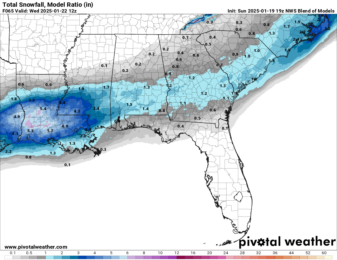
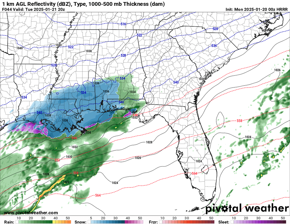
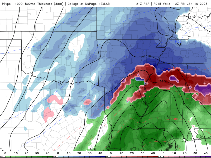
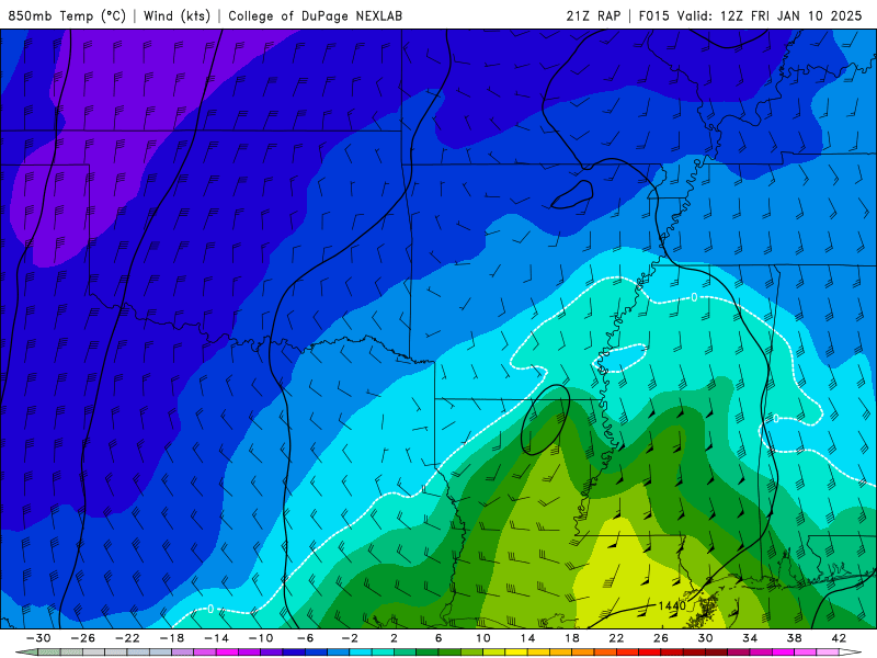
First I want to apologize for being late to the party and secondly this my first time posting within this thread but wanted to say my two cents regarding this event for the 12 to 24 hours. Wintry precip should be ongoing across AR and should start to see some of that wintry precip into West TN into northern MS within the next few hours and well into Friday with majority of the wintry precip ending by Friday night. For along I-40 and north will see mainly snow with amounts of 4" to 6" widespread. However, model guidance has beginning to increase those amounts closer to 10" to even a foot of snow in some places. This will be highly dependent on where the heavier snowbands will be located. For those south of the TN/MS state line, will see more of wintry mix throughout the night into early morning. The wintry mix eventually transition to snow as temps are expected to hit freezing. Those in North MS may not see snow as the there is a warm nose extends well into northern MS. This is where I suspect the freezing rain and sleet will be more persistent and could see some accumulations. What makes tomorrow forecast difficult for northern MS, is the location of the warm nose at the 850 mb and where that freezing will settle out as that will determine who gets what throughout the night into tomorrow afternoon. If sfc temps remain at or below freezing and a warm layer is still present, could very well see more freezing rain/sleet accumulations than snow. However, if temps both at the sfc and at the 850 mb are both below freezing, will see more snow/sleet than freezing rain. Regardless, I do suspect wintry precip accumulation across the region, but for some it will be matter of how much snow; while others it will be a question of what and how much. Please see images below for references of the precip type and 850 mb temp. Model data from 21z RAP from COD Weather.
.thumb.jpg.049f4a7f726ada07e8cd30bd17e713cb.jpg)