.jpg.60032c348ffbfe96450212c98c077602.jpg)
vortexse93
-
Posts
93 -
Joined
-
Last visited
1 Follower

About vortexse93

Recent Profile Visitors
1,586 profile views


-
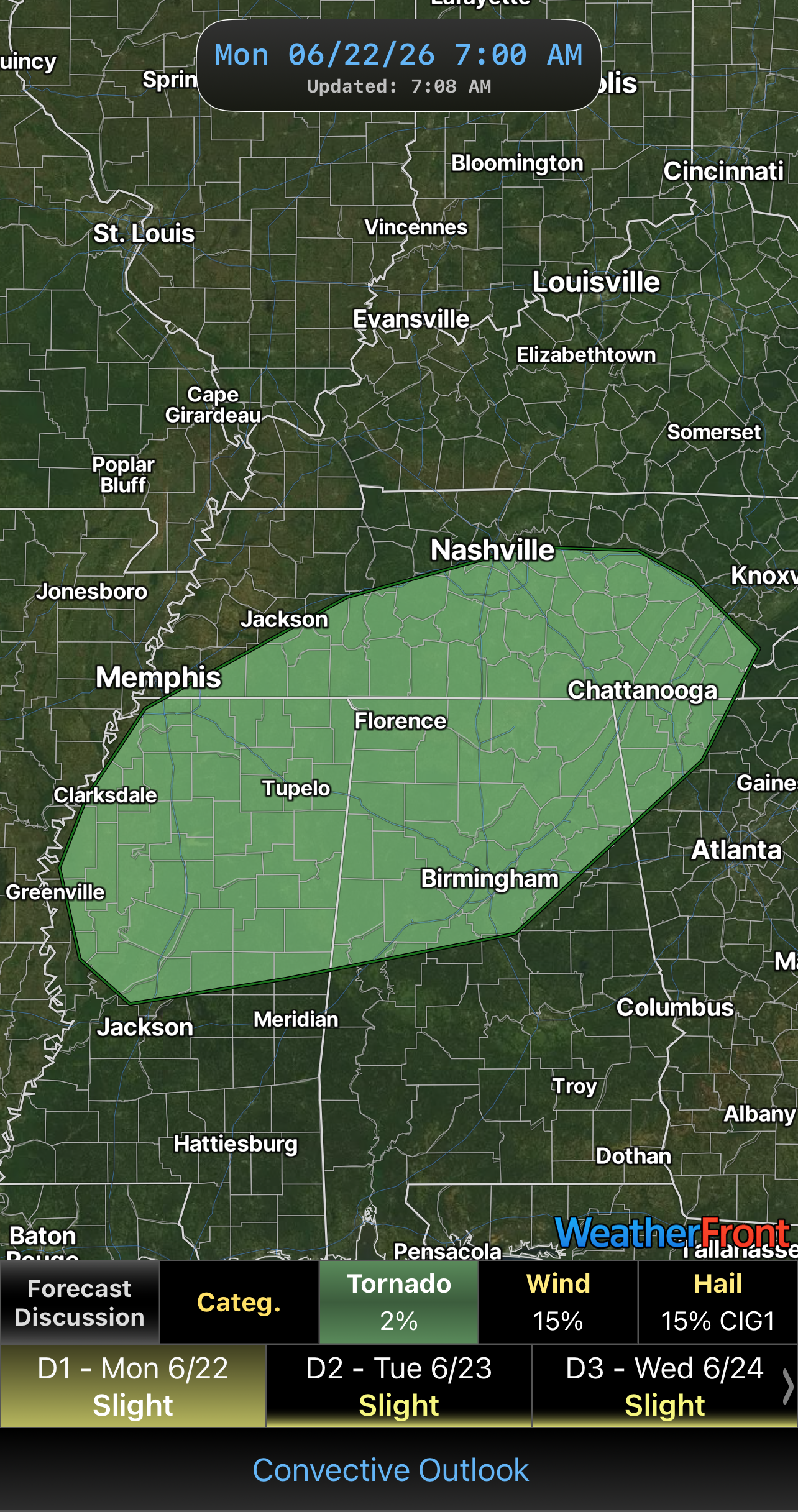
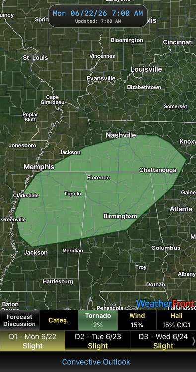
Looks like I might have a chance to chase after all this evening if things go right. SPC extended the 2% tornado just to my north. As @nrgjeffsaid, 2% strong Date: 6/22/2026 @7:10 AM
-
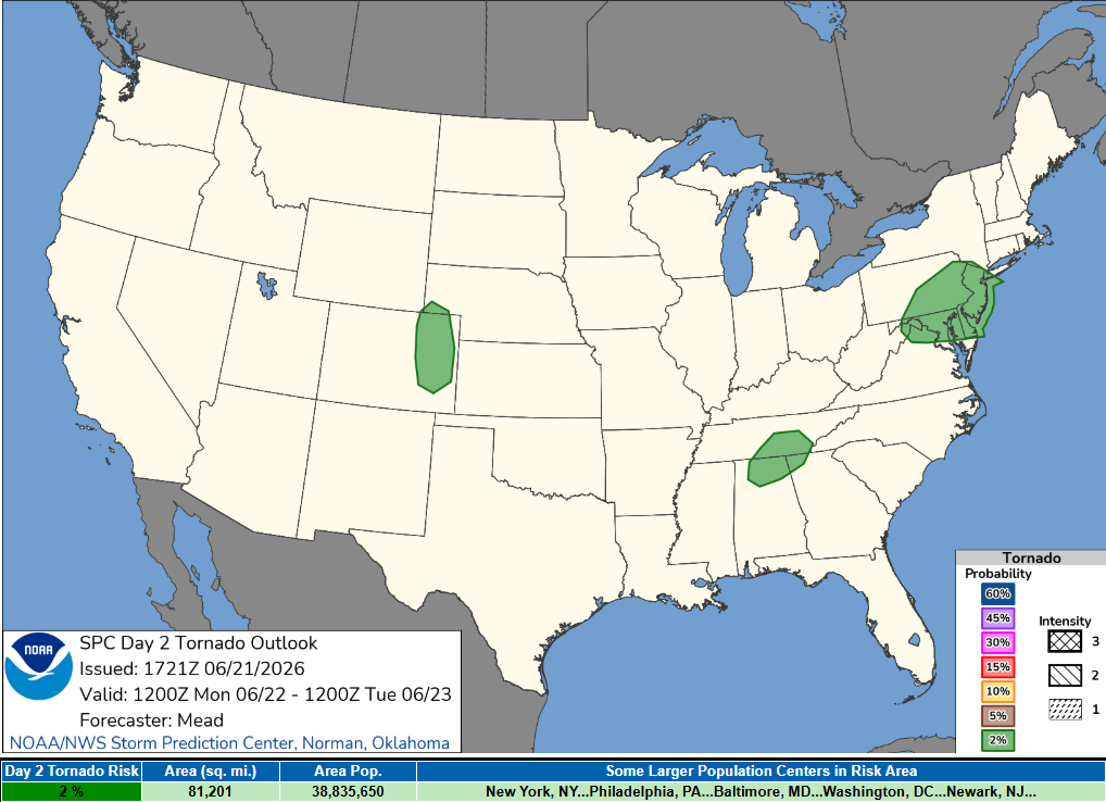
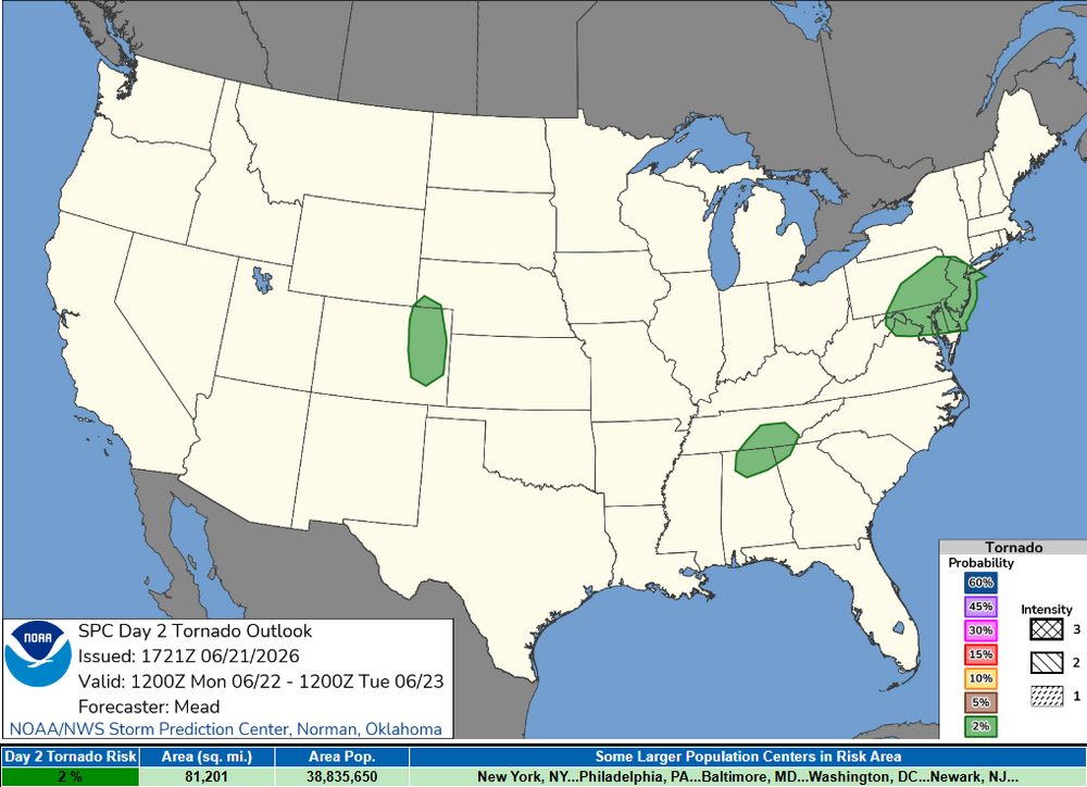
While I have not looked at anything for tomorrow in detail, it could be an under the radar type of day for those in northern AL into the TN Valley for a potential chase day. If I was closer and/or had the day off tomorrow, I would take the gamble to chase, but unfortunately, I am not in that position to chase for that setup. On the side note, would love to be in CO/NE/KS this week to chase landspouts given that the pattern for tomorrow looks to be favorable for it once again across that area, maybe one day I will see one. Date: 6/21/2026 @ 6:00 PM CDT
-
A New Hope? 12z EURO While this chase season has not been ideal for myself and probably for others as well, the EURO model does have an interesting feature that could provide myself an opportunity to chase and maybe salvage this year's chase season as well. This feature was also showing up in the 00z model run which suggest that this is not just a one-off model run and something to potentially keep in the back of one's mind for the moment. Will be very interesting to see how the EURO model trends over the next several days before making any real decision. I will say for the time being that location, timing and placement appears to be favorable with the 00z and 12z runs. 12z GFS As for the GFS, the signal is weak and not as apparent. This does cause for some concern as the two models do not agree on the overall solution and appear to have two different setups. The GFS also indicates that the system could be a mid-latitude cyclone coming out of the Great Plains rather than a tropical based system that the EURO is currently showing. In addition, placement of the synoptic forcing appears to be more focus towards the Plains and potentially the rugged terrain of AR and portions of MO which is not ideal for chasing. In short, will need to watch and monitor model guidance and model trends closely as this could be my new and probably last hope for a potential chase for the 2026 spring season, especially locally. Will need to see how the next few days pan out before making any real plans to chase. This is something I also thought would be worth noting for the time being as the severe weather season is winding down and chances for any chasing looks very dim outside of this for the time being. Date:5/28/26 @ 7:45 PM
-
I just got done glancing over the model data, does not look like much overall. I will continue to watch just in case it gets expanded or see if the threat continues into Saturday. Not looking great for me either, but at least I have the Delta if something were to go.
-
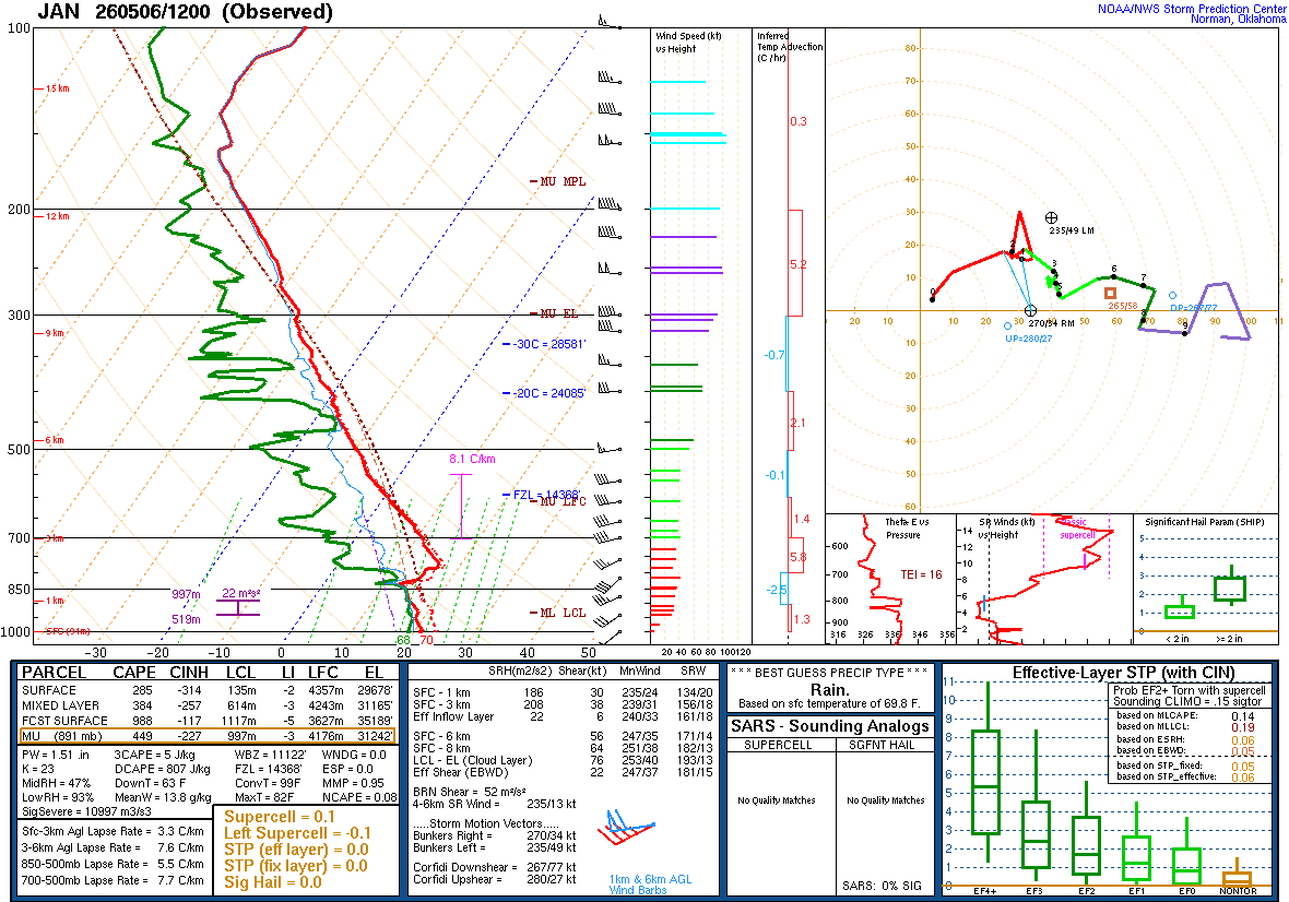
I took the sounding off of Pivotal Weather
-
Yes the forecast sounding was meant for 5/17/26 across the MS/LA Delta. I took this sounding from the HRRR from the day before and it actually showed a low end severe weather threat/maybe even a very low end tornado/landspout type day. Nothing really happened across the that area as storms struggled and some of the key parameters (not shown here) was not present for it to come to fruition. However, i think it’s cool to sometimes look at these lower end or even sub severe days to look for that diamond in the rough. As a side note, the morning of 5/17/26, the SPC did put out a marginal risk for severe storms which based on the forecast sounding was not a shocked.
-
Weather or Not (Pun intended lol) I know the big talk and focus is over in Tornado Alley for the next couple of days, rightfully so. Since I know there are people not able to chase this week, like myself, I would figure it would be something to fun to chat about and discussed. So feel free to play along!! Hint: Definitely not in Kansas anymore!!! I also purposely left out the information from the sounding but assure enough this is not bad data or just one model suggesting this either. Date: 5/16/26
-
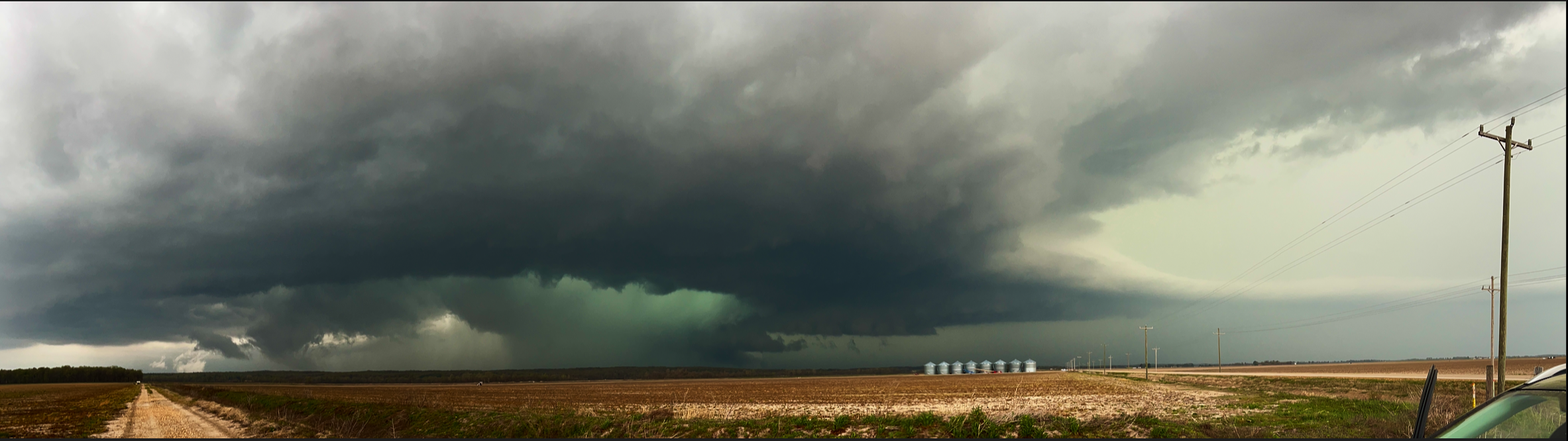
I decided against it as trees made it nearly impossible to navigate and the back roads all had a northbound component with little east or west options. Besides, the storm was HP (that has not stopped me before) but in the location it tracked there was no way of even getting a good view without putting myself in a very bad position. I’m also glad I did not chase because I-55 had to be shutdown in both directions as trees were blocking the road. This is also why I am so hesitant about chasing south of I-20. You kinda of make your decision with little to no other option of getting out once you are down there. To help me make go vs no go decisions, I use Google Maps and the street view to help get a better understanding of the road network or even possible intersections before chasing in my chase target areas. I tend to find it more successful when I do study my chase targets as it allows me to have a better understanding of what I might come across instead of going in blind. Even when I am thinking about going into the Delta, I like to have a rough idea of what roads will lead back to a major highway or interstate for my commute back or in case of an escape route. I also tend to find places where I can pull over at where I can get back on the road safely and with little trouble. I may miss more opportunities to chase when doing this, like last night, but I also know I much rather be comfortable and safe than unsure and feeling lost. My end goal of chasing is to photograph and document storms. I am not here to be the next Reed or anything like that. This is just a hobby for me.
-
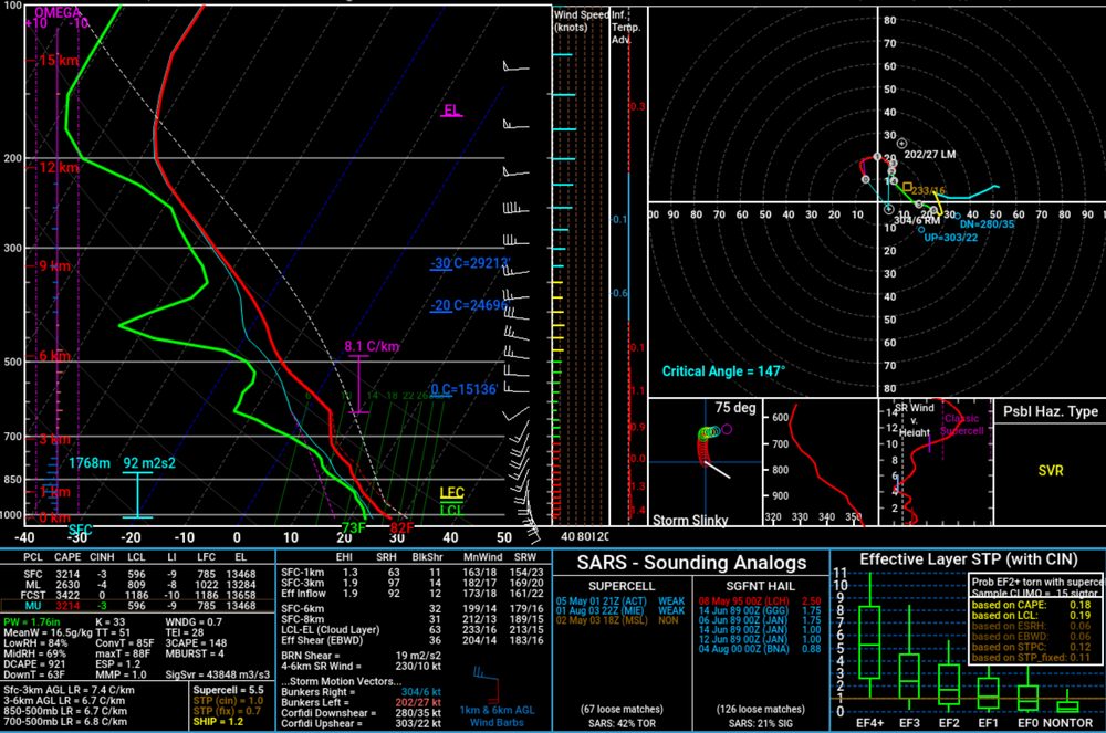
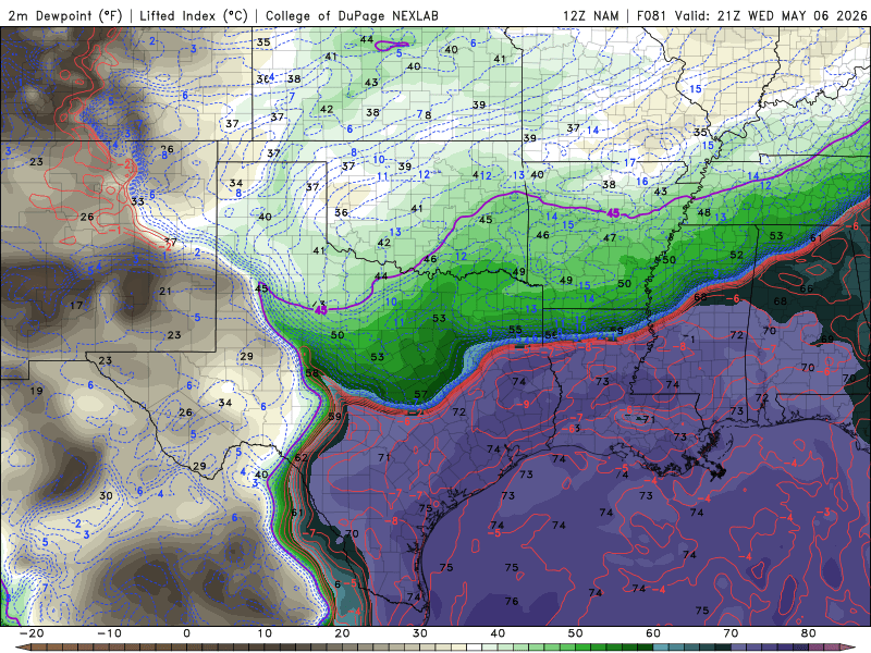
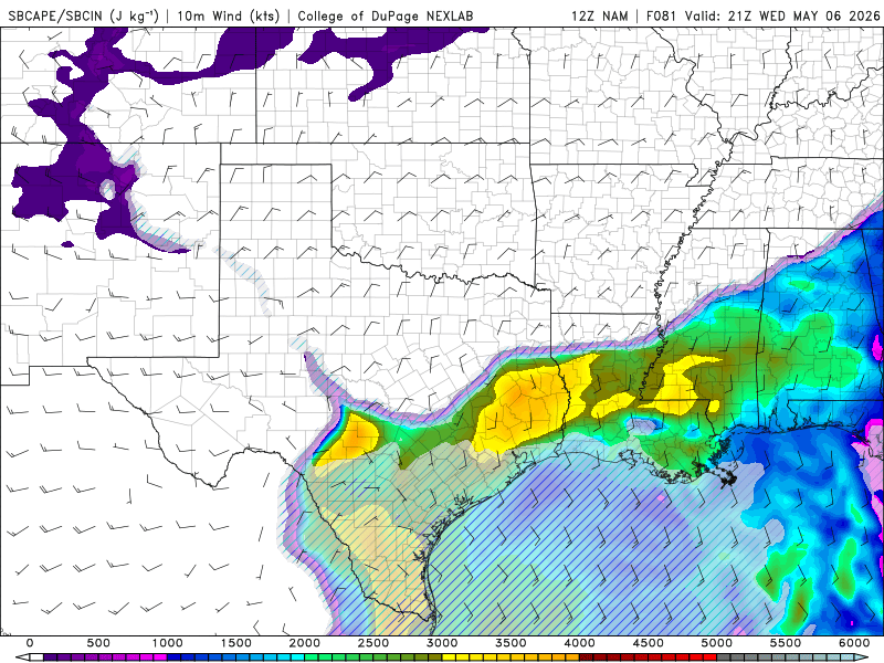
Wednesday 5-6-26 Morning Update 12z KJAN morning sounding shows a decent sounding to start the day off with the loaded gun appearance. Will need to see if any sunlight can break through the clouds to enhance mixing and help start eroding some of the cap away. My only concern at this moment is the wind profile at the surface. Still in need of some sort of outflow boundary to get winds to turn more southerly instead of southwesterly to enhance the directional shear across the area to have any chance of discrete/supercells this afternoon and evening. Current model guidance suggests that I-20 will be the dividing line. Model guidance however does not fully agree on if storms will be more favorable south of I-20 or north of I-20. Regardless, will need to watch to see how conditions will evolve throughout the day. Currently, would much rather chase north of I-20 where trees are less of a hassle/hindrance. South of I-20, trees are major issue so any potential to chase in this area will be considered unlikely. Chase target for me if storms develop along I-20 and north will be Canton, MS which is about 30-45 minutes north of my current location and have some decent options if needed. If I do chase south of I-20, options are extremely limited and will likely have to stick near I-55 or I-20 or maybe a major highway like Hwy 49 to have any chance of chasing or seeing anything worth noting. This decision is really undecided as I am waiting to see how morning model data trends and see how the environment will evolve by this afternoon. Date: 5/6/26 @ 9:05 AM
-
I am going to share this post and will add my thoughts to it. Tomorrow will be depend on the development and where the any potential outflow boundaries will setup at tomorrow afternoon/evening. Model guidance continues to show a messy line of supercells to develop across Central MS, right where the 10% tornado risk is currently highlighted in the graphic. The decision to storm chase or not remains up in the air as storm development will be on the edge of the Delta in to I-55 and I-20 area. Best case would be for a supercell to develop to my immediate north and meet it there before sun goes down which would be very doable. Will make the decision tomorrow afternoon as it looks like the storms will be close enough for me to make such a last minute decision.
-
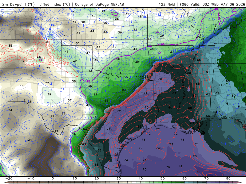
Tuesday 5-5-26 and Wednesday 5-6-26 Severe Wx Potential As mentioned in my previous post, Tuesday was going to be challenged for me to chase due to logistics reasons. In addition, there were are some questions whether the cap will break or not for storms to develop or not. Model guidance throughout the day has given increase confidence that storms will develop off of either 1) the cold front or 2) the dryline across AR/OK and even in TX pending which model and model solution. For MS/LA Delta, model guidance still has a low confidence in seeing any discrete storms worth chasing and will likely not be able to chase on Tuesday. However, Tuesday's storms could provide key insight on where old or lingering outflow boundaries could reside out for Wednesday. Pending on where these outflow boundaries are located at will likely determine my chase location and if the decision to chase will be worth it as well. Earlier model guidance did show potential for a lone discrete cell to develop near the Yazoo/Rolling Fork, MS area for Wednesday evening. However, the most recent model run of the RRFS has pulled back on this solution and will need to see what the other models show over the next next several hours. However, both the RRFS and the FV3, show storm development being consistent along I-40 where the frontal boundary is expected to stall out come Wednesday. Also, model guidance shows low confidence that the sfc Low will be present, but also weak. If this were to pan out, could very well see eastern AR into North MS and West TN being the main part of the action Wednesday night. However, just as I stated in my previous post, Wednesday could end up being more linear. This is also evident in the Bulk Wind Vectors as those are appear to remain more parallel than perpendicular to the frontal boundary. I do think there could be some discrete cells on both Tuesday and Wednesday, it looks like it will turn linear very quickly or at the very least a messy Congo line (as I like to call it) of storm cells along the frontal boundary. For Tuesday, chasing will be out of the question for sure as it will be out of reach for me right at this moment. For Wednesday, I am going to wait and see what the other CAMs will show and perform before making a decision. As of right now, chasing looks doubtful given potential storm mode and location of storm development as well. Date: 5-4-2026


-
Wednesday Severe Wx Potential Looking into the model guidance this morning and it appears there could be a severe weather threat for Wednesday afternoon/evening for Central MS into eastern TX. My chase area will focus be focused within the MS/LA Delta as the terrain the region is suitable for chasing as there will be little trees and hills to obscure my view while chasing. The only factor will be the Mighty MS RVR, but that can be easily managed pending on storm track, storm mode and storm speed/motion. Beginning with 00z on Wednesday with the 12z NAM run, the frontal boundary is orientated southwest to northeast. This orientation provides a nice dividing line between the warm sector and the cold sector for storms to develop for Tuesday afternoon/evening. However, the threat for storms will be located well out of my reach and will not be able to chase on Tuesday unless the threat for severe storms extended eastward into MS Delta on Tuesday, which there is little confidence that will occur. By 21z Wednesday, the cold front will have taken over the warm front and will have a west to east orientation by 21z Wednesday. If this were to occur, any discrete or supercells will be extremely limited and will likely be dealing with a linear event, unless some outflow boundary can cause some pre-frontal convection in the warm sector for Wednesday afternoon/evening. While model guidance shows southerly winds and instability within the region for Wednesday afternoon/evening, the 850 and 925mb winds shows a weak LLJ and only a slight wind shift towards the southwest. With these factors combined, Wednesday could likely be more of a linear event and possibility for discrete cells will likely be limited at this time. At this time, I am not impress with this coming up system for a potential chase, especially this far out. While I did skip over Tuesday, I will continue to watch to see if model data will change or convince me to chase on Tuesday, but challenges for Tuesday would be more logistics based and not meteorological based at this time. For me to chase Tuesday, the threat for the MS/LA Delta will need to extend towards the region. A Day 3 Marginal Risk for severe weather does not work for me, especially when it is concentrated towards NE AR/ NW TN/MO. Date: 5/3/2026
-
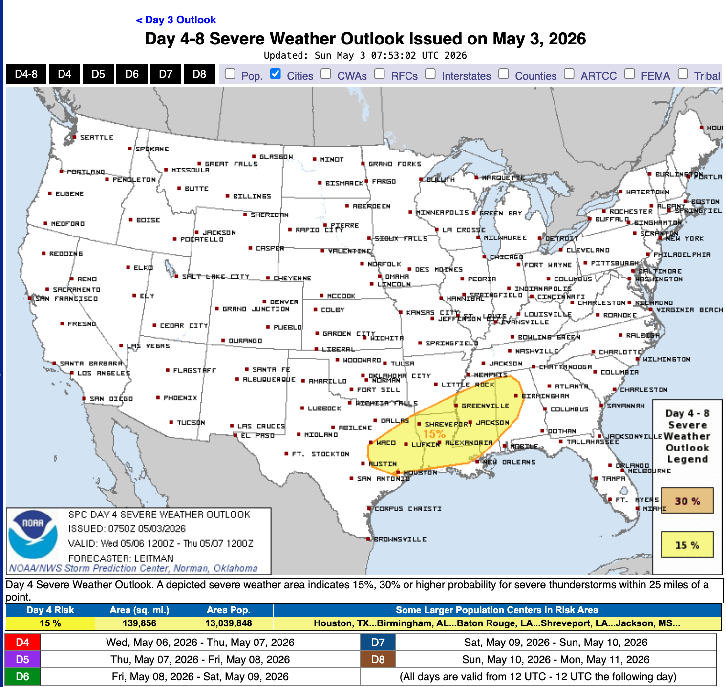
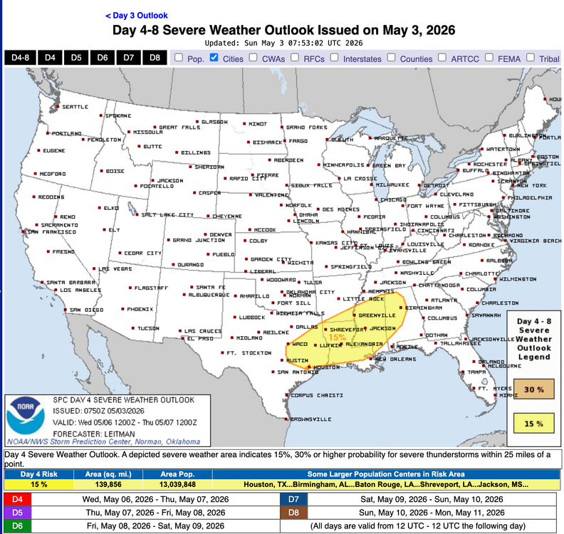
If SPC Day 4-8 Outlook holds true, might see a few more post from me in the coming days.
-
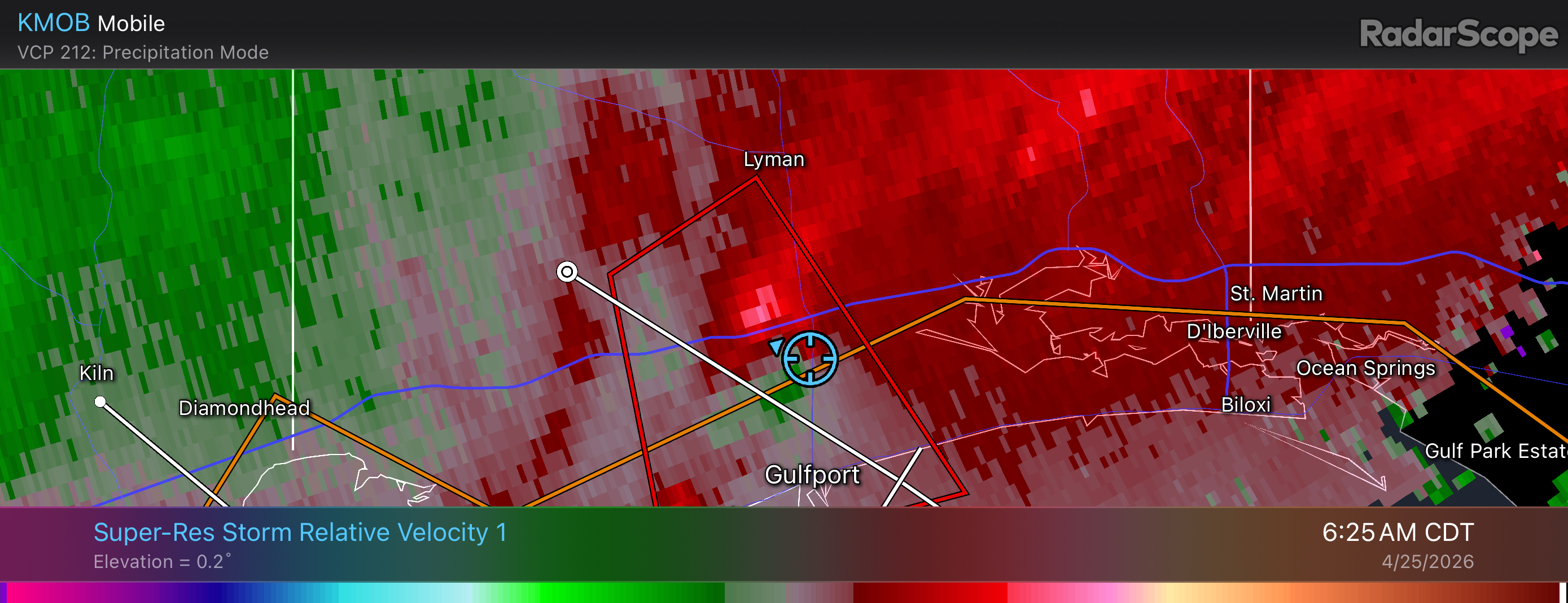
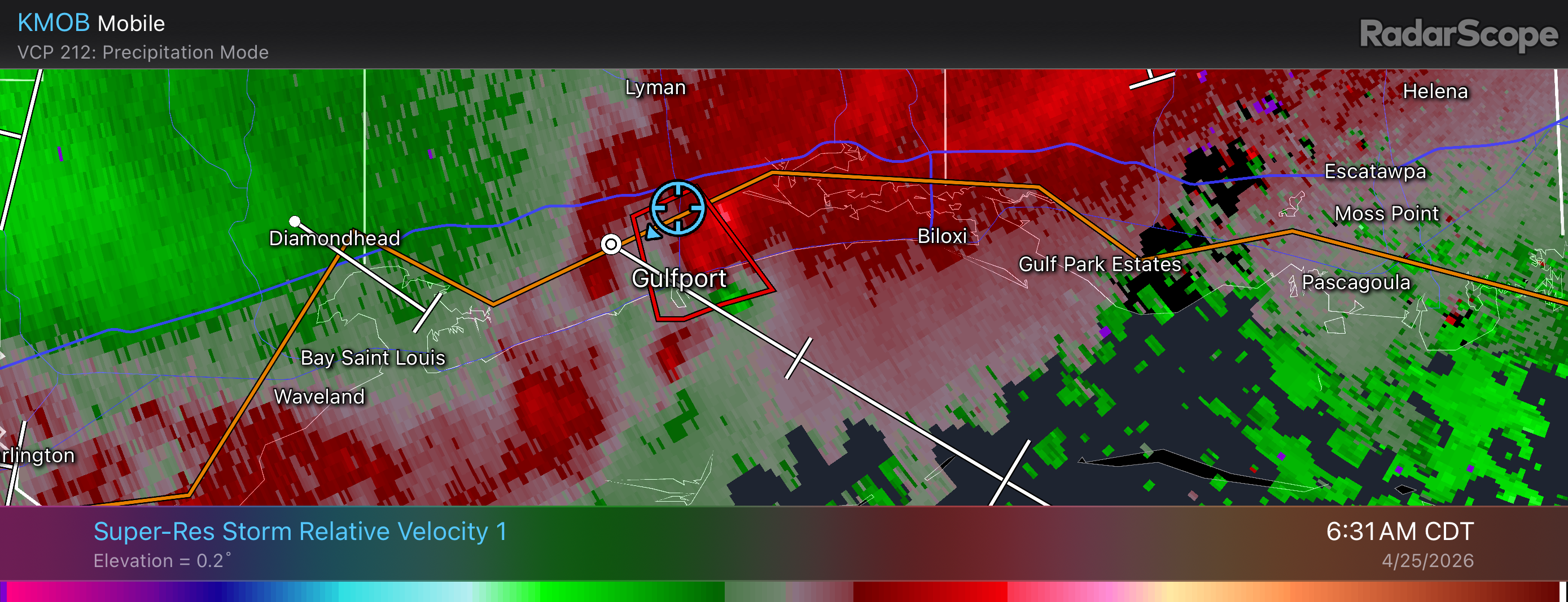
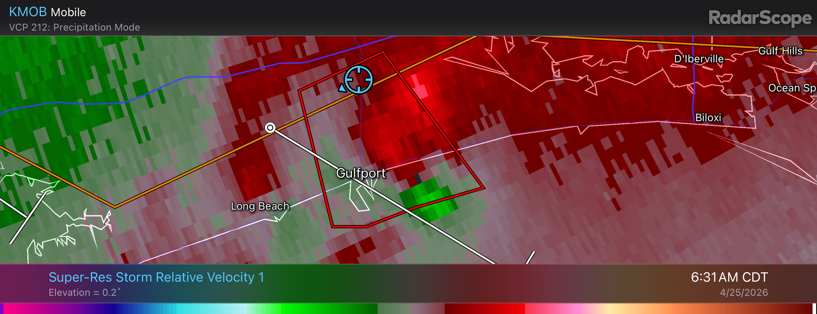
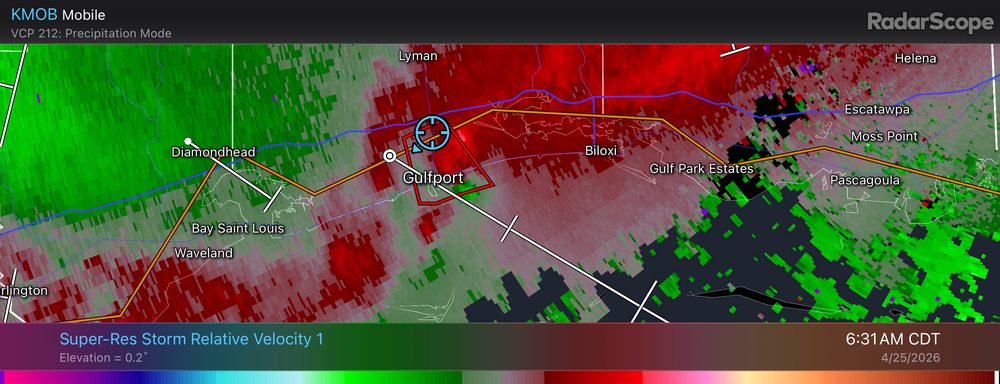
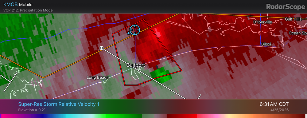
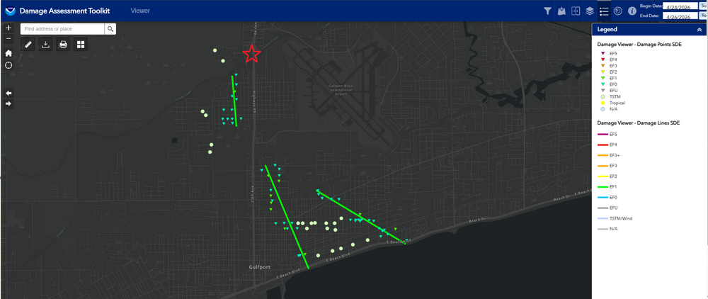
Gulfport Tornadoes 4-25-26 As @jaxjagman pointed out, there was a tornado that came within the vicinity of the JAN area on the 24th of this month, but I was out of town and was in no danger of being hit. However, that did not last very long as the QLCS pushed southward through the overnight hours into the early morning hours on the 25th of April, I had three different tornadoes that nearly hit me while I was out of town. Below are the radar images time stamped of the circulation along with my location as it went over my head. In addition, I am adding the NOAA/NWS Damage Toolkit to give context on how close the tornadoes came to hitting my hotel. There was damage with tree branches being snapped and even fences being damaged along HWY 90. I was not aware or saw any evidence of a tornado that touched down near HWY 49 earlier as there was little to no damage at my location outside of some power outages at some of the intersections with very minor tree damage. I was unable to get any pictures of any of the tornadoes as they were brief and heavily rain wrapped and could not be done safely. Disclaimer: The red star on the map is a rough estimate of where I was at in reference to the three tornadoes that had occurred the morning of April 25th, 2026. The radar imagery does contain the GPS location from RadarScope for supporting evidence as well.

-
I am all good. I am sorry for being MIA this season. Work has gotten in the way and plus with a slow season, I tend not to be as active also.
.thumb.jpg.049f4a7f726ada07e8cd30bd17e713cb.jpg)