

TradeWinds
-
Posts
542 -
Joined
-
Last visited
1 Follower

About TradeWinds

-
2025 Atlantic Hurricane Season
TradeWinds replied to BarryStantonGBP's topic in Tropical Headquarters
Everywhere I guess since the entire water column is below 78F.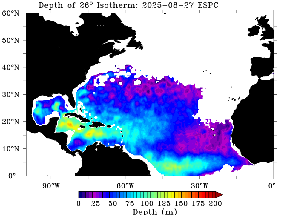
-
2025 Atlantic Hurricane Season
TradeWinds replied to BarryStantonGBP's topic in Tropical Headquarters
SSTs took an absolute beating NC and north. Agree that current weather shows no opportunity for recovery. A hybrid storm north of NC could still happen but anything tropical would likely rapidly weaken. Water temps are in 60s in some places and oceanic heat content is very low. SC and south still has fuel. Offshore buoys in FL in mid 80s and still upper 80s in some places off FL east coast. Steering pattern still in protection mode from East. -
2025 Atlantic Hurricane Season
TradeWinds replied to BarryStantonGBP's topic in Tropical Headquarters
The new, state of the art WSF-M just achieved IOC in April. While the Space Force paid for it, NOAA is in talks with them. There are also other microwave imagery data still available to civilian agencies. Also, for the record, the decision to spilt the civilian and defense weather satellite programs was made in 2012 under the Obama Administration. -
Orlando international just measured an 86 mph gusts per WFTV. That's on the front side.
-
Siesta Key https://x.com/Fox35Amy/status/1839660622092353635?t=57UvOaG1txVU46SaPgw25A&s=09
-
Tampa https://x.com/JaneCastor/status/1839647578297950448?t=sBtY5ZuzzhskG8xBG6tUkw&s=19
-
Makes you wonder. Maybe closer to alignment.
-
Looks more like the eye tightening up on the left side.
-
Center clearly shows an easterly movement on radar last hour, even NE. Wonder if the center is still aligning which will wobble it back and forth.
-
You'll see decent squalls especially as it lifts north. Areas of central and north central peninsula probably will see their worst conditions Monday instead of today as it gets a more easterly movement and the plume drags with it.
-
It's still elongated at the center but you can see it coming together. There won't be any rapid intensification until it gets fully aligned.
-
As currently forecasted, just squally weather in Orlando at times. Our biggest impacts are typically when they enter near SWFL. Watch for trends.
-
Is the blob everyone is focused on the one just NW of Jamaica? That seems like a typical MCS that pop up with unorganized systems. The recent blowup of convection on the southern tip of Cuba has my attention.
-
Cuban radar looks like broad circulation but generally centered over the land mass.
-
Like Jeanne but further west. Ha

