.jpg.b9a795a9fe89b3aa2ead015665ae36fe.jpg)
nvck
-
Posts
458 -
Joined
-
Last visited
Content Type
Profiles
Blogs
Forums
American Weather
Media Demo
Store
Gallery
Everything posted by nvck
-
.thumb.jpg.ad3a2e31d30aff035044689b311a0540.jpg)
1/24-1/25 Major Winter Storm - S. IL, IN, and OH
nvck replied to A-L-E-K's topic in Lakes/Ohio Valley
Almost a textbook coupled jet... Wow -
1/24-1/25 Major Winter Storm - S. IL, IN, and OH
nvck replied to A-L-E-K's topic in Lakes/Ohio Valley
Orographic lifting over there could do some crazy things .... -
Winter 2025-26 Medium/Long Range Discussion
nvck replied to michsnowfreak's topic in Lakes/Ohio Valley
my moment for -teens wish this pattern would've set up a month ago when i was back home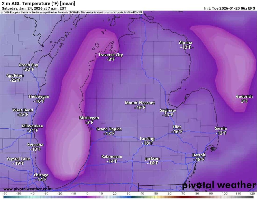
-
Winter 2025-26 Medium/Long Range Discussion
nvck replied to michsnowfreak's topic in Lakes/Ohio Valley
Am thinking that the southern portion of the sub could cash this weekend, especially as this has been trending a little north recently, coming in line w/ the EPS.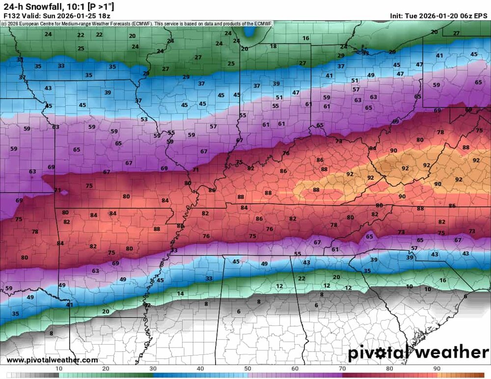
-
Winter 2025-26 Medium/Long Range Discussion
nvck replied to michsnowfreak's topic in Lakes/Ohio Valley
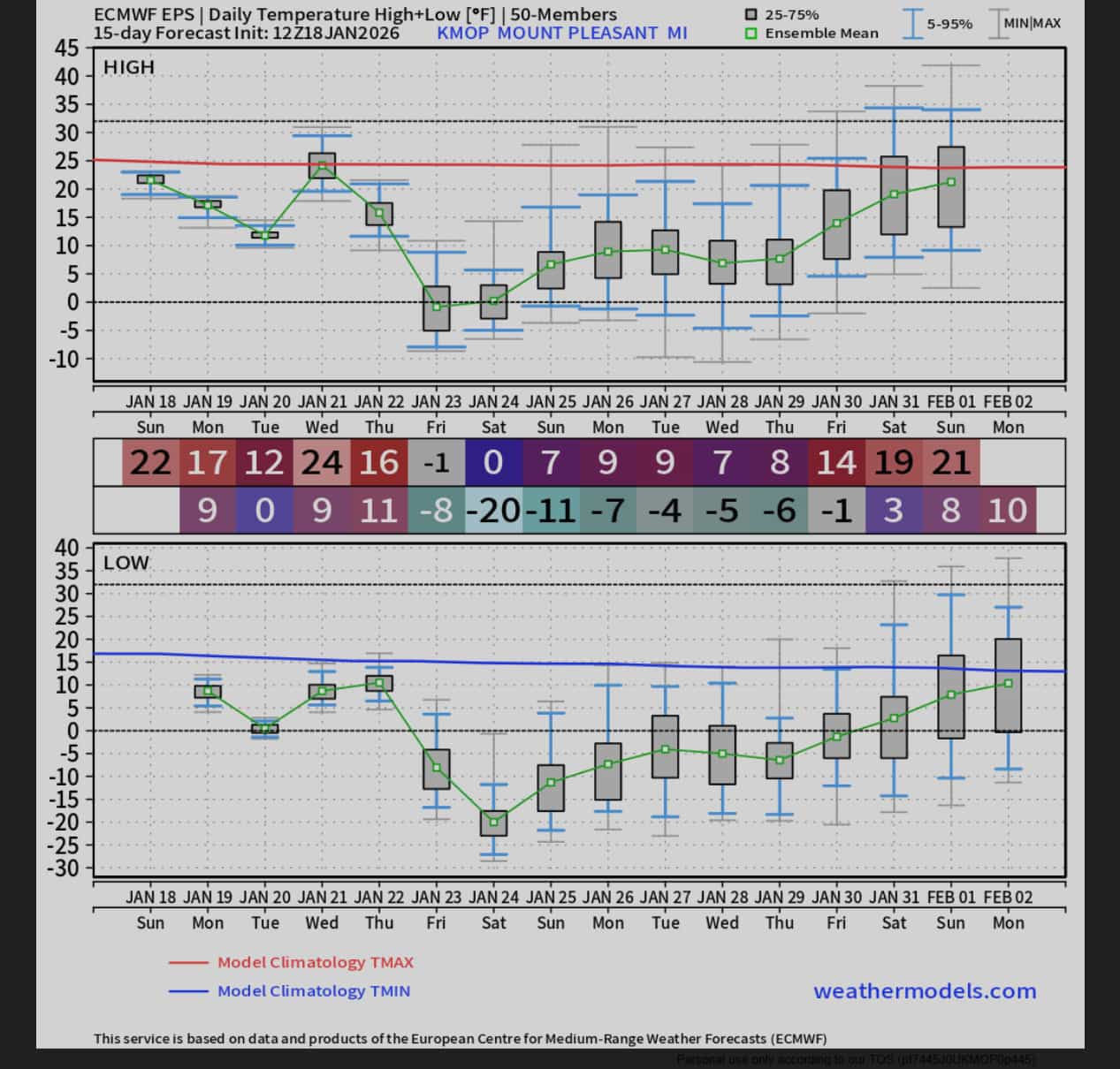
Record lowest max temp for jan 23 in mt pleasant is 7. New euro ensemble has a high of -3 on that day.... -
Winter 2025-26 Medium/Long Range Discussion
nvck replied to michsnowfreak's topic in Lakes/Ohio Valley
euro ensemble keeps trending colder for next weekend, though the gefs has yet to really cave.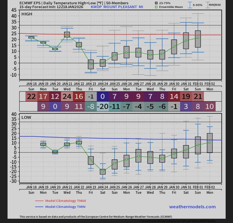
-
Winter 2025-26 Medium/Long Range Discussion
nvck replied to michsnowfreak's topic in Lakes/Ohio Valley
OV the place to be next weekend ??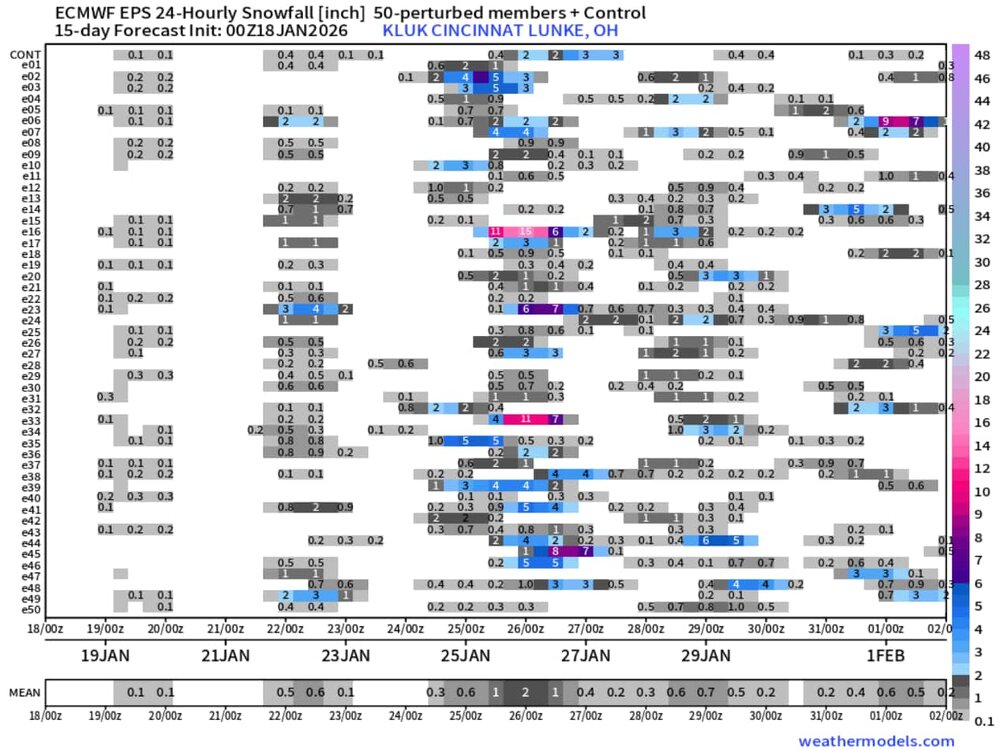
-
Winter 2025-26 Short Range Discussion
nvck replied to SchaumburgStormer's topic in Lakes/Ohio Valley
light snow been on-and-off (mostly on) here since the early am. def a very wintry feel, looks like we could cash on some heavier squalls tn if we're lucky.
-
grass was almost halfway covered this am... does that count?
-
pretty nice timeseries from the campus wx station today, sw winds really ripping through campus, and we're a few degrees above modeled for the afternoon.
Scaled(32_).thumb.jpeg.a0a4f602971efdf65bd54cdd55911a67.jpeg)
-
71 here already, gusting to around 35. looks like some interesting stuff going on in C IL rn.
-
Winter 2025-26 Medium/Long Range Discussion
nvck replied to michsnowfreak's topic in Lakes/Ohio Valley
bro has been crashing out on twitter too -
Winter 2025-26 Medium/Long Range Discussion
nvck replied to michsnowfreak's topic in Lakes/Ohio Valley
You'll never guess what the new one looks like...BAMWeather(@bam_weather)_X.thumb.jpg.430a616771c8fb3ac29e2985fa47e513.jpg)
-
https://arstechnica.com/science/2025/12/trump-admin-threatens-to-break-up-major-climate-research-center/ Ik people stay away from politics here, but this would be awful if it happened. even if nothing happens (it probably won't), I hate that our field is politicized needlessly, and this really undermines the stability of the work they do at ncar
-
hitting 54 today has dissolved whatever snowpack remained from Saturday. Was nice while it lasted, but will take a couple weeks of warmth before (hopefully) a return to the cold
-
Winter 2025-26 Medium/Long Range Discussion
nvck replied to michsnowfreak's topic in Lakes/Ohio Valley
https://x.com/i/status/2001009884540834205 Fwiw (not much, probably) -
thinking that somewhere in the middletown to wilmington to circleville area is gonna cash w/ 7-8", just have gotta get lucky with the these bands of higher rates.
-
Really coming down here now, starting to accumulate on grass/vegetation, not much on the roads yet though. Temp is just below 32f, so hopefully it starts dropping soon and we see some higher ratio stuff move in
-
bengals tickets for a game w/ low teens air temp and sd's wind chill are going for about $20 on the upper bowl, lower for 40-50. Will probably be there, thats almost too good to pass up.
-
Wow that clipper today trended real far south and real weak, local mets have been scrambling to drop totals, the ones who had 3-5 for the Cincy metro really caught out, looks like most will be lucky to see 2.
-
We closed twice last year for cold, but never had enough snow to close for that
-
University delayed start until 11am, doesn't really seem like 4" would warrant that, but I guess so
-
Started coming down here around a half hour ago, hoping for a good 4-5 inches
-
crazy what a difference a few dozen miles makes
-
Winter 2025-26 Medium/Long Range Discussion
nvck replied to michsnowfreak's topic in Lakes/Ohio Valley
looks like 4-6" probable here by tomorrow afternoon, the hrrr finally got with the program and came way south.


BAMWeather(@bam_weather)_X.jpg.f9f68a607f047ac529337f5bb8b76a04.jpg)

