
nvck
-
Posts
180 -
Joined
-
Last visited
Content Type
Profiles
Blogs
Forums
American Weather
Media Demo
Store
Gallery
Everything posted by nvck
-
pretty big bust so far here, most of the snow is just north of mt. pleasant. Had about 30min of light snow earlier, which laid down like 0.2", and I think we could get maybe 1" more with a slight south tick. GRR had us at 2-4" this morning.
-

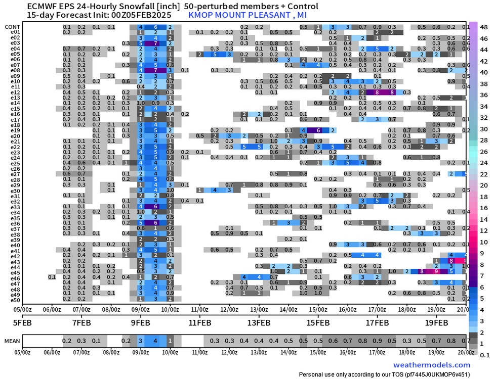
Winter 2024-25 Medium/Long Range Discussion
nvck replied to michsnowfreak's topic in Lakes/Ohio Valley
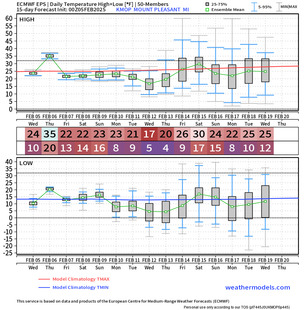
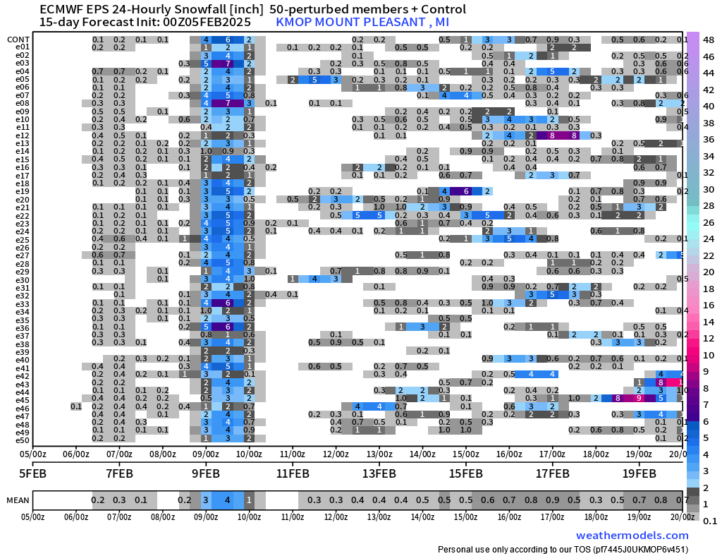
pretty surprisingly high agreement on temps over the next week or so, and then ensembles are all over the place after that. EPS is showing the biggest snow event of the year for mid-michigan, which would be nice.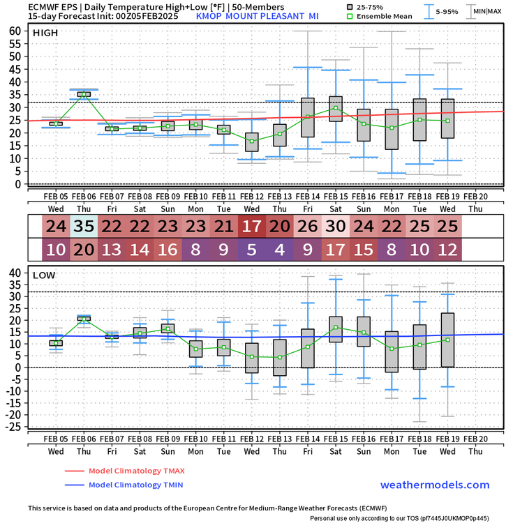
-
NAM3 is definitely an outlier in SW ohio, selling widespread 0.1-0.15", but idk if anyone's noticed that it's been way colder than other models these past few weeks. Like, it's got KLUK with a high of 42 on thursday, and the model avg is 50, with HRRR and NBM higher than that.
-
KLUK got up to 70° as of the 2pm obs. Would take that in a heartbeat over the 32° and gray here
-
Yeah, I was hoping that the grass would at least get re-covered, but it's still mostly bare. definitely underperformed
-
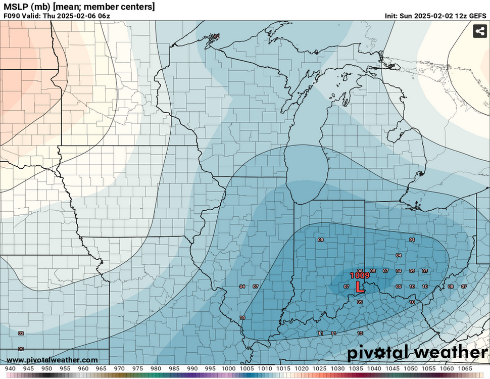
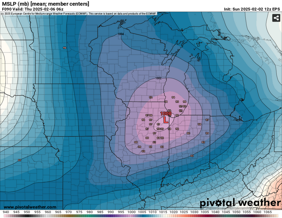
never started a topic before, but figured this storm could use one, as it's got the potential to be a significant event for our area... went ahead and x-posted the latest gefs/eps MSLP products from the other thread
-
Winter 2024-25 Medium/Long Range Discussion
nvck replied to michsnowfreak's topic in Lakes/Ohio Valley
GEFS has trended a little bit stronger, and maybe slightly farther north over the past couple runs, and the EPS has trended stronger, and clustering around Chicago the past several runs. Someone will have to cave soon.... 18z NAM should be interesting, with this system showing up at the end of the run.
-
Picked up maybe 0.5" this morning, drove to harrison yesterday, and it's wild how much more snow is otg up there compared to here.
-
Winter 2024-25 Medium/Long Range Discussion
nvck replied to michsnowfreak's topic in Lakes/Ohio Valley
Seeing some pretty interesting discrepancies with the Euro & GFS for the Weds night/Thurs morning system. Euro and it's ensembles bring a pretty significant ice-storm to most of Michigan, and have the low center around the IL/IN border at 6z on thursday. The gfs and gefs, on the other hand, have the low centered around OH/KY/IN at that same time, with not much precip making it up this way. The euro solution also appears to be significantly deeper as well. (1004mb compared to the gefs' 1012mb). fwiw, the CMC ensemble basically just goes between the other two, lol. -
Not sure if anyone else uses this site, but https://www.anyawos.com/metar/WeatherNexus is a pretty good resource for up-to-the-minute obs from a bunch of small airports around the midwest, but mostly in MI and MN.
-
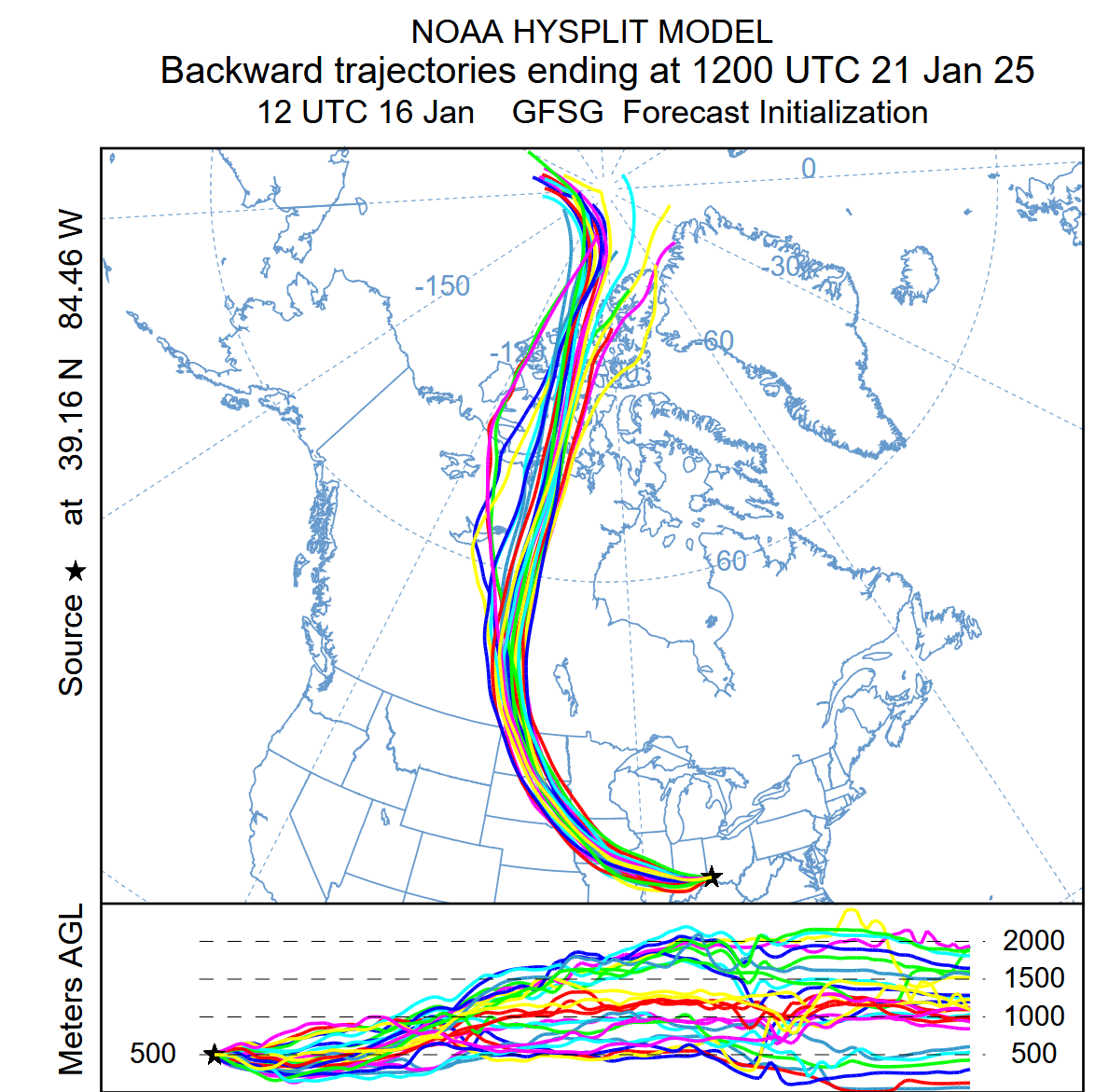
Appreciate it! Was gonna share this graphic but wanted to make sure I understood it completely first
-
If I'm understanding what this tool does correctly, this basically means that the air mass over cincinnati the morning of the 21st is coming from northern canada/the arctic, right?

-
I know it's not panning out for the rest of the sub, but Cincinnati is part of the way to a top-10 or top-5 January, with 11.1" so far, the 22nd snowiest since 1893, and way better than the 4.3" last January. The system potentially coming next weekend could put us in that top-10 category.
-
Timelapse of the snow in cincy, 26 hours down to 90 seconds https://www.facebook.com/share/v/188qhYx72o/
-
I measured about 7.5" at 9:30 this morning in Milford, probably around 9" by now?
-
haha yeah, I wasn't really complaining, but interesting to see the demographics that make up the subforum.
-
right, but still, a pretty large area was impacted. kinda shows the population distribution, and how concentrated a lot of the sub is in N IL, wisconsin, and michigan
-
yeah! this slow-moving band is awesome
-
I can't believe we've had a Winter Storm across multiple states, bringing close to a foot of snow in some places, and everyone is either talking about lake effect, or complaining about their snow
-
Let’s talk winter!! Ohio and surrounding states!! 24'-25'
nvck replied to buckeye's topic in Lakes/Ohio Valley
Anyone buying the additional 5-6" the hrrr shows? -
Mostly light since about 11 here, maybe 0.5-1" on the ground but roads are getting covered. Stronger band moving in now
-
Are mping reports not working on radarscope/ any other outside service for anyone else? I can see them on the https://mping.ou.edu/display/ site, but not anywhere else. edit: actually, looks like the certificate for that site expired at 12z this morning... wonder if that impacts other apps ability to access the reports? Hell of a time for that to happen...
-
Radar shows snow, but a hefty wedge of dry air in the lower bit of the atmosphere - just waiting for that to get eroded and then we're off, hopefully!
-
Let’s talk winter!! Ohio and surrounding states!! 24'-25'
nvck replied to buckeye's topic in Lakes/Ohio Valley
Getting kinda worried about dry air intrusion, and that most intense band of precip moving south of the river -
Anyone have any opinions on the WPC experimental winter precip probability maps? Am wanting to include them more in my forecast process as they seem like a good super-blend, but didn't know what the thinking was around them