
nvck
-
Posts
180 -
Joined
-
Last visited
Content Type
Profiles
Blogs
Forums
American Weather
Media Demo
Store
Gallery
Everything posted by nvck
-

March 14-15 Severe Weather Event (Outbreak?)
nvck replied to HillsdaleMIWeather's topic in Lakes/Ohio Valley
Saturday looking bigger than Friday for both the northern and southern modes
-
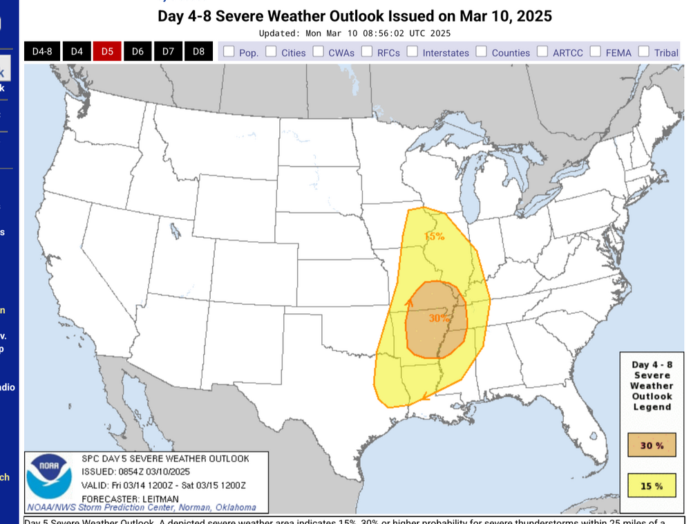
Is it worth starting another thread for what looks to be a 2day severe weather event? Expecting that both of these risks will be expanded northwards

-
Lock it in! I'm expecting 0.5" of rain on Saturday, with a few rumbles of thunder
-
Looks as though the first trough next week isn't going to be as strong as was thought earlier, and therefore the next (much more potent system) has more moisture to work with farther north. Also, depending on the timing the trough progression, I could see Saturday also being a decent severe wx day in the eastern bit of the sub, and into the midatlantic
-
https://x.com/ItzRoch11/status/1898430186380484745?t=k9tcfmbrBPZkv892UlEblg&s=19 Someone ran a WRF model on GFS initial conditions for Friday. Take with (many) grains of salt, but still interesting
-
Driving back home from MI, ground was basically completely bare the whole way, though there was a dusting just N of Ft Wayne, where a pretty strong band had been sitting for a little bit. Flurries from Lansing to there basically, but nothing was sticking really. Hoping to bag some 70s this week before a return to the frozen north.
-
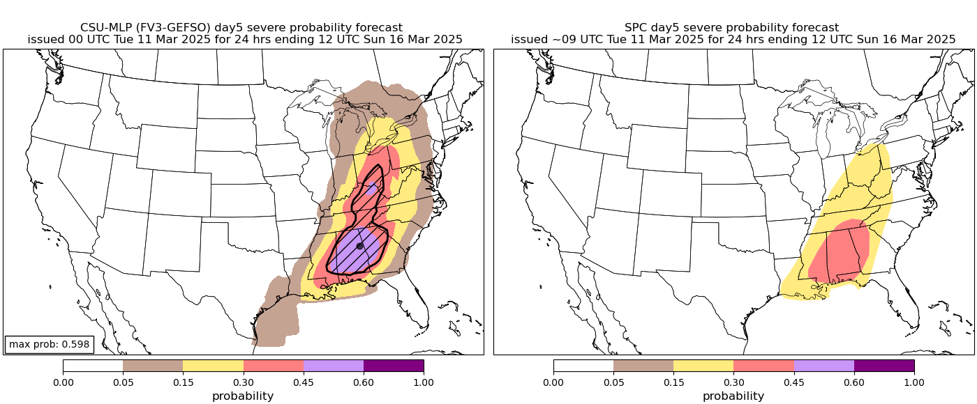
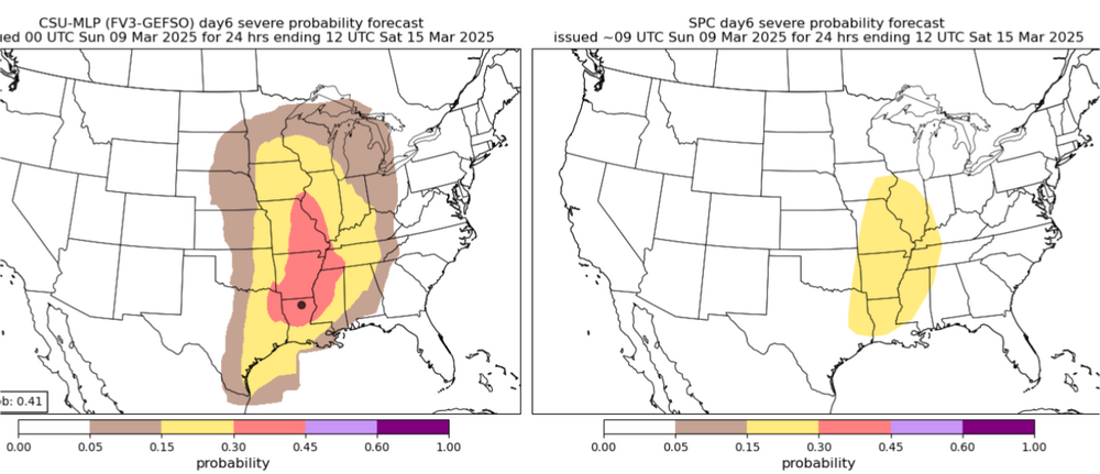
In the CSU d8 ML forecast we trust

-
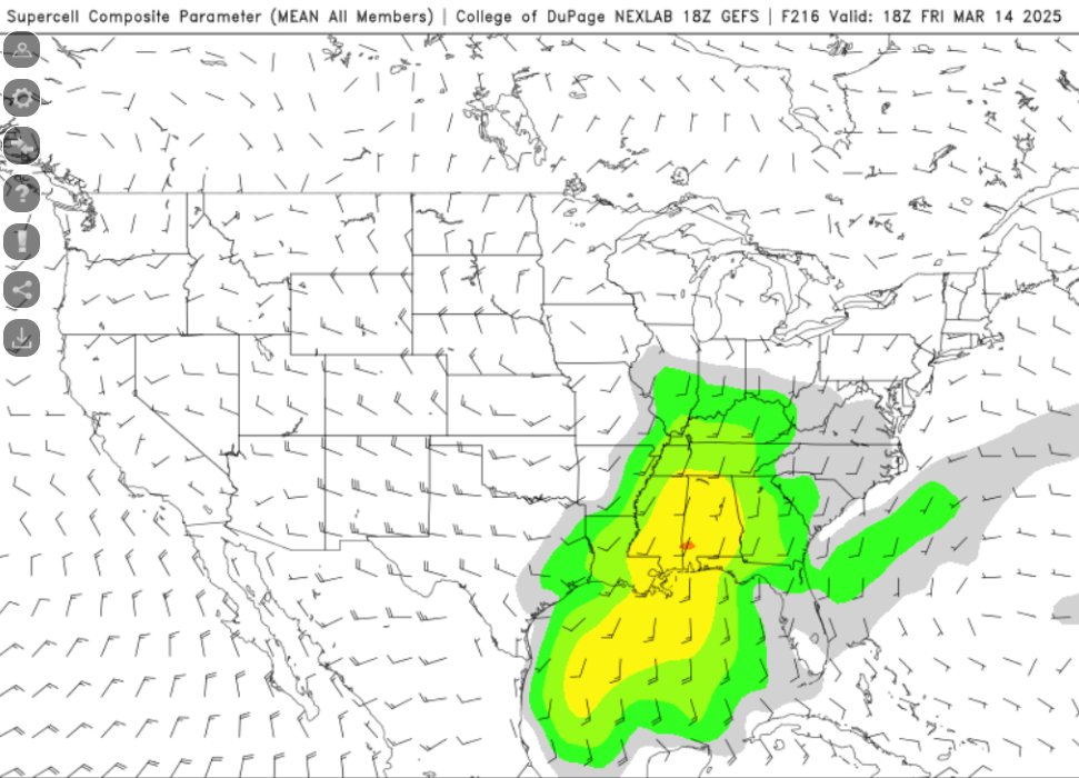
Ensemble support as well for a *potential* severe outbreak in the SE and S Ohio River Valley. Will obviously have to watch how this evolves, but seeing SCP values this high 200+ hours out on the gefs is surprising
-
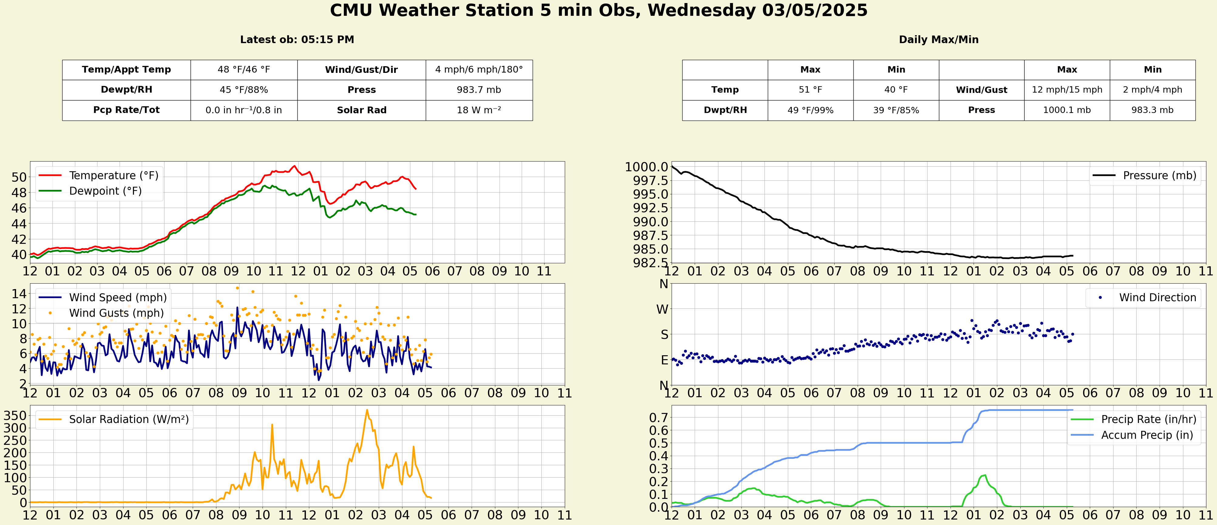
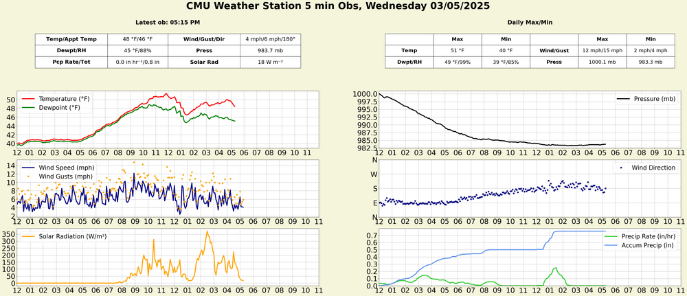
Pressure bottomed out in the low 980s, after a pretty steep plunge this am. precip on the day around 3/4", and upper 40s feel incredible
-
6z gfs (and 00z euro) both want to run back another sub-980 low late next week, with more svr possible in the south

-
But I didn't think the leapords would eat *my* face!
-
Winter 2024-25 Medium/Long Range Discussion
nvck replied to michsnowfreak's topic in Lakes/Ohio Valley
not in our bit of the country, but it's pretty wild that we can issue outlooks 7 days out, that have a decent chance of verifying.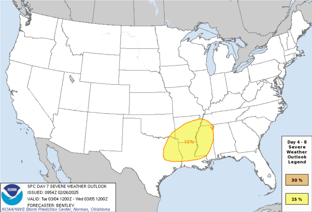
-
Absolutely incredible day in store here, 10am and it's already up to 42 which feels like the 50s after the past few weeks. W/ the sunny skies and a nice SW breeze I'm thinking we top 50. Could not be more excited
-
I definitely haven't, only been to Lake Huron and mostly central/southern Lower. Yeah, lots of math w/ the MET major, after calc 2 comes diff eq/linear algebra, and then calc 3 after that. supposedly calc 2 is the hardest, which I'm really hoping is true.
-
No, the farthest north I've been in MI is Tawas City last March (which didn't have any snow at the time), but I'd like to go up to that area at some point if I can ever get some free time. met major classes are no joke, especially calc 2
-
18z NAM didn't really back down, although it is a pretty significant outlier with this far north of a track

-
Yeah, foot otg is looking very unlikely with the depressing 12z runs. I've not measured, but maybe 6" rn? Again, that's a very rough estimate
-
Snows yet to start here, but looking forward to the potential for over a foot of snow OTG when this is all said and done, would easily be the most I can ever remember seeing.
-
agree, and i've gotten into arguments about this w/ people, at what point does making something clickbait with the premise of "more people will know about it" turn into people ignoring any threat because they are all this overhyped.
-
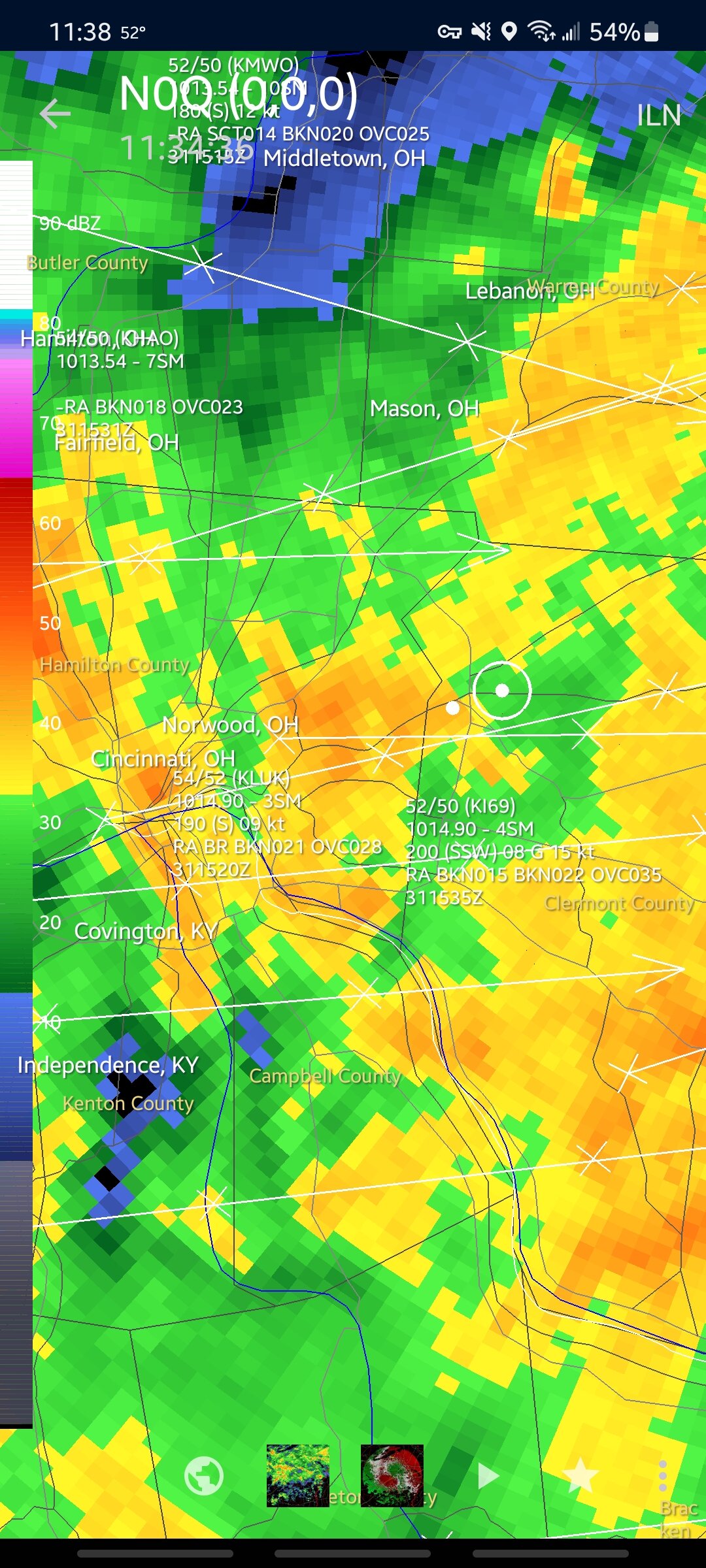
different system than the one everyone is hyped about, but ILN put up WS warnings for NC KY counties, with WWAs for NKY and the southern tier of ohio counties
-
might explain why it's been so high on the OV storm tomorrow, and dumping 3-4" over cincy where other models have 1-2"
-
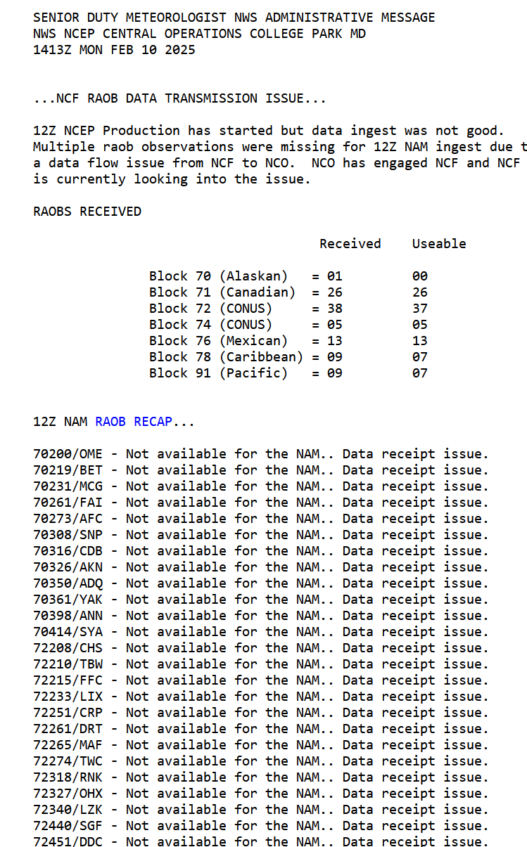
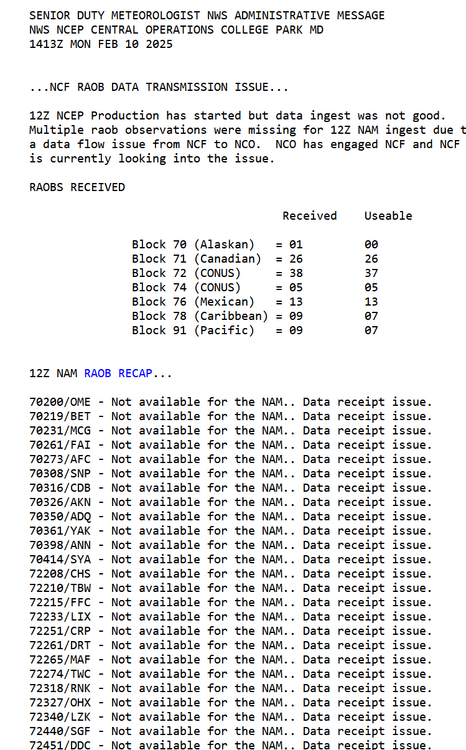
apparently the 12z run of the NAM did not ingest upper-air data properly, per https://www.nco.ncep.noaa.gov/status/. messages/ so I wouldn't put much stock in it.
-
huh, I guess it didn't last as long as I thought it did, thats pretty impressive then
-
Ended up with 2-3” I believe, didn't do any measurements but enough to cover the grass is a success in my book! That band slowly moving south this evening really saved us, with decent rates for a couple hours
-
Thanks man, yeah that heavier band finally ticked south a bit and we've actually got decent rates atm. i honestly just want the grass to get mostly covered, it makes the cold so much more palatable