Bob Chill
-
Posts
35,956 -
Joined
Content Type
Profiles
Blogs
Forums
American Weather
Media Demo
Store
Gallery
Everything posted by Bob Chill
-

January Medium/Long Range: A snowy January ahead?
Bob Chill replied to mappy's topic in Mid Atlantic
Yessir. Temp wise the pattern looks pretty much climo norms with a bias towards colder to me. But it also looks like the storm track could be anywhere along the eastern 3rd of the country. We are in the heart of cold snow climo with the minimum temp anomaly required. Timing is good for the general setup. Down the line keeps looking more and more like jan/Feb 2014-15 lol. The ultimate progression would be a couple weeks of the +tnh pattern followed by a -AO/NAO reload. Hahaha -
January Medium/Long Range: A snowy January ahead?
Bob Chill replied to mappy's topic in Mid Atlantic
Looks like at least some snow is favored in the majority of the juicy solutions but they are likely mixed events. Unusually trong agreement d10+ that a precip maker hits during the 20th window. Pretty tight grouping for long range. Should consolidate over the coming days. Hopefully the snow idea consolidates with it lol -
January Medium/Long Range: A snowy January ahead?
Bob Chill replied to mappy's topic in Mid Atlantic
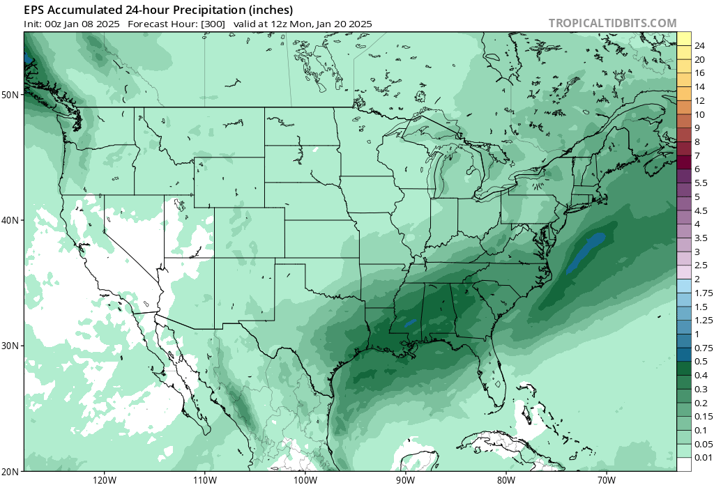
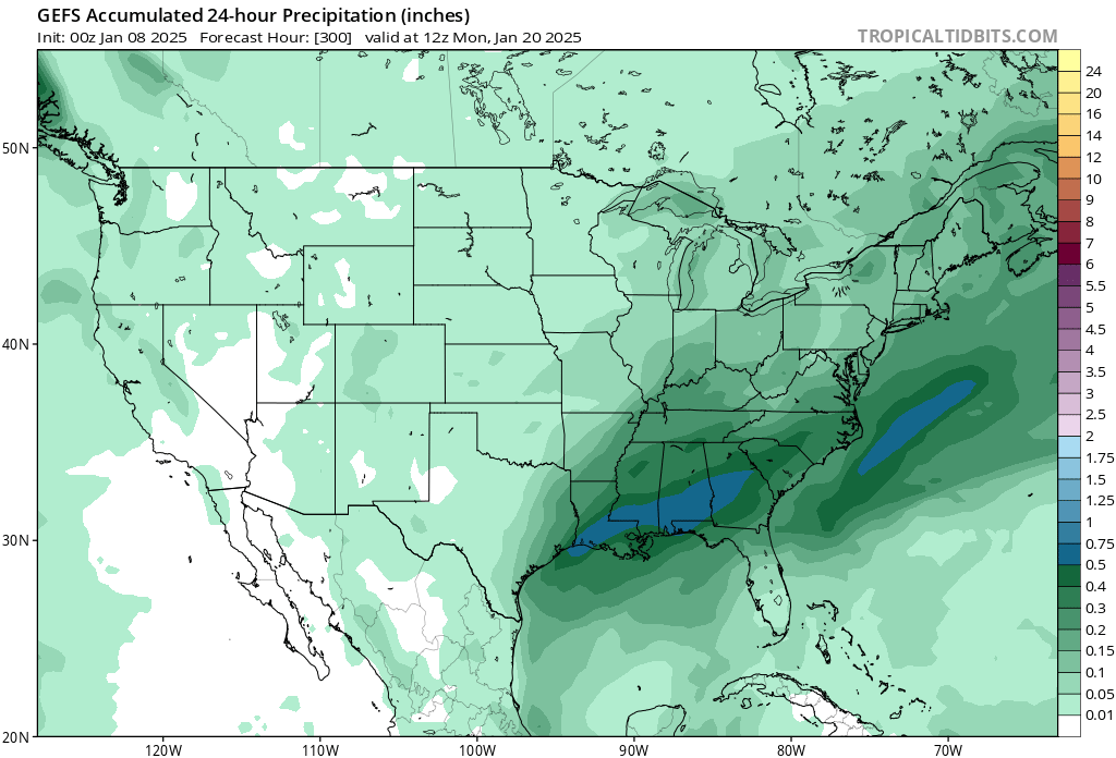
If you don't mind, post the same with precip and not snowfall. Would give a good snapshot at rain risk with juicier solutions. -
It's easy in the sense that it's overrunning along a boundary and not a dynamic low pressure system. This isn't really a storm as much as a modest precip shield gliding thru. Different variables and far less dynamics makes this more cut and dry
-
Things haven't wavered here much. Different perspective than what you guys are looking for. That said, this is an overrunning system more than anything. Moisture streaming from the SW with modest lift in the general MA area. Would take very little to get the 2-4 line running thru at least DC. If models keep adding to the northern extent today and tomorrow, it's unlikely for them to go poof again.
-
The boom potential is prob just simple moisture transport. How juicy can it get before deteriorating upper levels? Neutral or neg tilt seems near impossible at this point so just need the slug to be coherent as it pulls north. Won't be fun watching it weaken as it approaches but not much you can do about it
-
I'm rootin hard for a nice event in my old stomping ground. Why? Because it means my new stomping ground is doing even better.
- 957 replies
-
- 12
-

-

-

-
January Medium/Long Range: A snowy January ahead?
Bob Chill replied to mappy's topic in Mid Atlantic
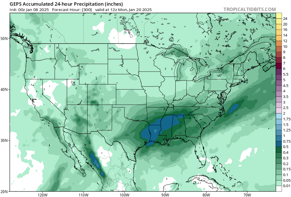
Hard to not like this trio of ens mean panels even though it's late in their runs.... Crazy similar for d12+. Uncommon for sure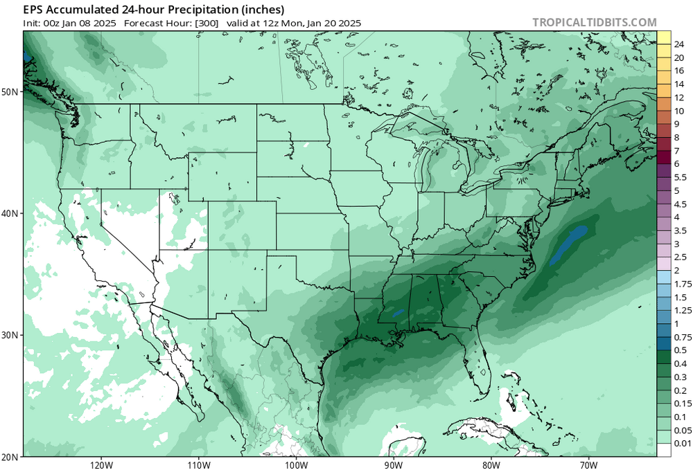

-
January Medium/Long Range: A snowy January ahead?
Bob Chill replied to mappy's topic in Mid Atlantic
Agree. Something can still wiggle thru but there is little if any chance at an organized system for the next 10-12 days. Interesting after though. Plenty of residual cold and no big mechanism to kick it out. A basic cold front would be enough to flip to snow ready if we go warm for a few days. Ens mean precip panels pretty much agree that the next organized system is coming out of the deep south so gulf appears open. CAD/west tracks could work "ok" if we can't get something more classic. Optimism is pretty high for me even if things get a little messy -
January Medium/Long Range: A snowy January ahead?
Bob Chill replied to mappy's topic in Mid Atlantic
What's your favorite flavor? I like magenta -
January Medium/Long Range: A snowy January ahead?
Bob Chill replied to mappy's topic in Mid Atlantic
I'm kinda surprised the euro didn't at least make a small move better. It's pretty dang juicy down south. Euro goes all ginsu n chit as it comes north. -
January Medium/Long Range: A snowy January ahead?
Bob Chill replied to mappy's topic in Mid Atlantic
Train tracks -
January Medium/Long Range: A snowy January ahead?
Bob Chill replied to mappy's topic in Mid Atlantic
Been liking this one a lot. A fairly uncomplicated 3-6 deal all snow falling on frozen ground. First event in 3 years to do that here. You're in a decent spot too. I never felt like this one had the pieces for a big event so I'm getting pretty excited. Gfs is prob a top end solution. 3-4" would look amazing around here. I'll take a ton of pics cuz it may never happen again -
January Medium/Long Range: A snowy January ahead?
Bob Chill replied to mappy's topic in Mid Atlantic
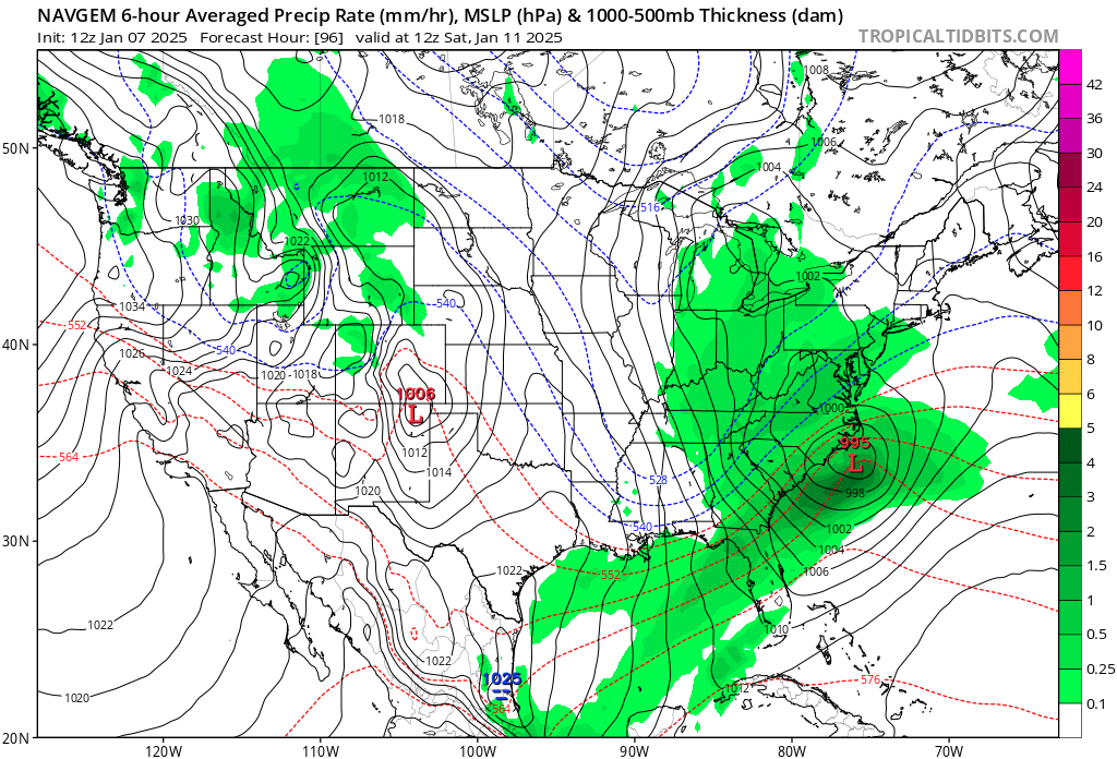
Progressive NAVGEM moved towards juicier and closer to the coast. And before anyone asks.... yes, the NAVGEM is an excellent model. But only when it shows what you want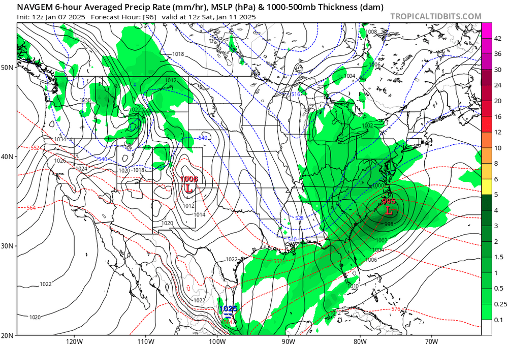
-
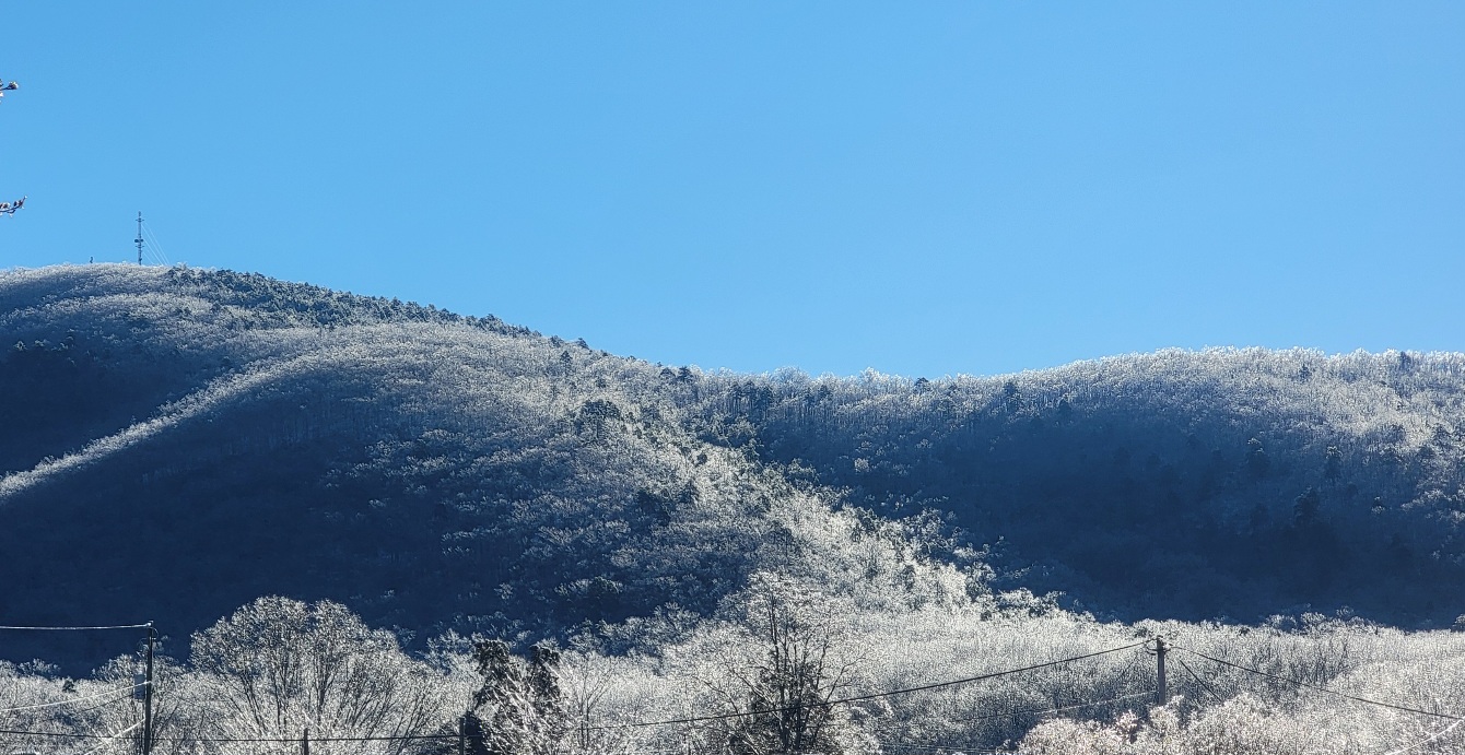
One of the most scenic ice storms I've witnessed maybe ever. Sun cleaned things pretty good today but this AM was sparkle city. Pics don't do it justice


-
January Medium/Long Range: A snowy January ahead?
Bob Chill replied to mappy's topic in Mid Atlantic
Sorry @stormtracker, I can't read when getting digitally jacked. Appreciate the consideration from waaaaay down Herr @Buddy1987 I've liked this setup from afar. Yesterday was always going to be a temp problem for me/you. This one is right in the zone for an all snow event that sticks from the start. We're getting close to locking in 2-4 with boom potential. Pretty stoked! -
January Medium/Long Range: A snowy January ahead?
Bob Chill replied to mappy's topic in Mid Atlantic
Don't overlook the Roanoke/Penhook deathband jack... -
January Medium/Long Range: A snowy January ahead?
Bob Chill replied to mappy's topic in Mid Atlantic
Triple phase storms show up at long leads because (usually) there is a phase no matter what. Big dogs have special ingredients. They aren't subtle. 93 tripled and became a record breaking beast but a large strong storm was already a near guaranty well in advance. Its been a long time since the last triple....maybe we're due... heh -
January Medium/Long Range: A snowy January ahead?
Bob Chill replied to mappy's topic in Mid Atlantic
This colder/active stretch looks much more like a nino than nina in the northern hemisphere. I talked about this in the fall. I never thought this winter would behave like a typical nina. Nino hangover no doubt has its hand in the cookie jar. One of the reasons I was a little bullish early on. I had some good guesses this fall so far but they were just experienced based intuition guesses. I get that stuff wrong plenty but my confidence was high this year for reasons I can't really explain even to myself lol Does it continue? Idk. Gut says nino hangover look will break down and not come back. We're getting pretty far into winter now. If things stay colder/active, I don't think it will look the same. Prob getting ahead of myself but intuition is telling me that a more zonal/boundary type regime will be the next money maker if there is one. Less amplified pna and hints of a SE ridge. Blocking can flatten the ridge and create zonal flow with cold fighting warm. If that happens the gulf will be involved by default. Just throwing ideas around. I cannot predict the long range future any better than mets, models,and longtimers here. Much uncertainty lies ahead -
January Medium/Long Range: A snowy January ahead?
Bob Chill replied to mappy's topic in Mid Atlantic
Yea, it's been looking like that on the balance for like 3 days. Because things are strung out when they get here, big rates is prob unlikely. But temps below freezing and frozen ground will maximize lighter rates. Our area in general looks close to the sweet spot outside of a bomb. Even a bomb works quite well but it includes jealousy hahahaha -
January Medium/Long Range: A snowy January ahead?
Bob Chill replied to mappy's topic in Mid Atlantic
Outside of a nuke, best case scenario is to have the southern vort as juiced as possible when it turns north. Even modest NS interaction like a frontal boundary or ribbon of vorticity can keep things cohesive enough for a very nice event. Can't have a stream duel. They need to be nice to each other in some way. ICONs version can def work and improve without a bomb -
January Medium/Long Range: A snowy January ahead?
Bob Chill replied to mappy's topic in Mid Atlantic
Idk about that. Southern stream is ripping. To me it looks like the NS is messing it up more than assisting. But it's the Nam doing Nam things at a range it shouldn't be allowed to run lol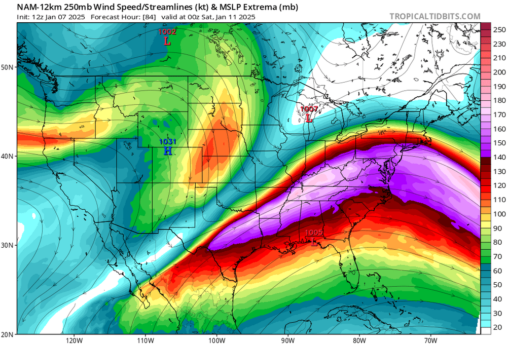
-
January Medium/Long Range: A snowy January ahead?
Bob Chill replied to mappy's topic in Mid Atlantic
Upper levels lose lift and instability. Moisture is still there but the mechanism to wring it out gets pulled apart from messy interaction. Think of it like 3-4 way tug of war, very confusing and nobody usually wins. Doesn't mean that's locked in though. Just how it looks now. Northern stream is notorious for mid range surprises (in all directions). Difficult to model. @psuhoffmani agree 100%. We can have epic dry periods in any season but the last 4 years or so has taught me the same thing. When precip happens, a propensity to bust on the high side seems far more common than the other way around. If it pulls north all juiced up, my gut says it translates down stream no matter.... -
January Medium/Long Range: A snowy January ahead?
Bob Chill replied to mappy's topic in Mid Atlantic
Tough call. This current 2 week period could end up being the coldest/most active period of winter but I have my doubts for now. I'm expecting a -ao reload before any extended thaw. Otoh, winters don't behave the same as they used too so climo/history doesn't work as well as it used too. Right now the current AO dive still looks more like a classic 4+ week period versus a hit and run. Nothing surprises me anymore though -
January Medium/Long Range: A snowy January ahead?
Bob Chill replied to mappy's topic in Mid Atlantic
The current AO dive peaked at -4 and no signs of a legit flip yet. A relax is inevitable and ens guidance is honing in on it mid month but more importantly, what happens beyond will define a good chunk of Feb. My gut says another dive of lesser magnitude is the most likely. If that happens, front half of Feb will continue with a decent regime for winter wx. Even if/when things aren't lining up, winter will be lurking close by. Ens spread is wide. My money is on the big + flipper camp is wrong. Neutral waffle or elevator down is where my head is