Bob Chill
-
Posts
35,956 -
Joined
Content Type
Profiles
Blogs
Forums
American Weather
Media Demo
Store
Gallery
Everything posted by Bob Chill
-
I had to take my then 6 year olds (fookin 20 now lol) to a bday party in silver spring. It was snowing moderately and stuck everywhere immediately when we left. I knew then it was going to work. The party was awesome. A handful of parents were weenies so we just watched snow pile up and enjoy for 4 hours. Driving home was fresh tracks in a lot of places. Dry cold snow makes for easy driving. My yard clocked 7" iirc and being a reverse bust made the day unforgettable.
-
Boxing day hit at the perfect time for maximum hope and dream destruction. Recency bias of the 2009-10 had us all overconfident lol. I was nearly certain it would work even when the wheels got loose in the short range. Nope, boxing day performed exactly like many of its predecessors. It's a big club and we ain't in it lol
-
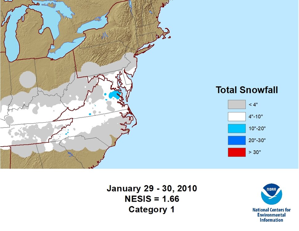
Here's the map of Jan 29-30 2010
-
It might look like boxing day at the surface but unless my memory really sucks..... h5 is not a match at all so as depicted it's a similar result with a different setup. Jan 30 2010 is still the best analog imho
-
Buddy, I'm 100% all in on 3-6". I'm only referring to expecting 13-16" lol. Front side WAA has performed well up and down the EC this year. Juice comes easy to waves that tap the gulf. This will be no exception. It's going to be a very efficient storm with minimal waste. .3-.5 qpf will lay down 3-6" with ease imo and right now, the risk is upside and not down.
-
Other than some op eye poppers, I never saw much evidence for a big/classic storm. The term big ones sniffed out early also includes ops showing big solutions over and over. We really only had a mid range pocket of solutions that did that. For every big run there was a scary one and analogs never stacked up with big solutions. Hard to ignore that and remain grounded in reality lol. This storm does seem primed to dump a foot on someone. Small area like the last one. Overall snow shield is much larger this go around. I'd like to think it makes a lot of people happy but I'm second guessing that lol.
-
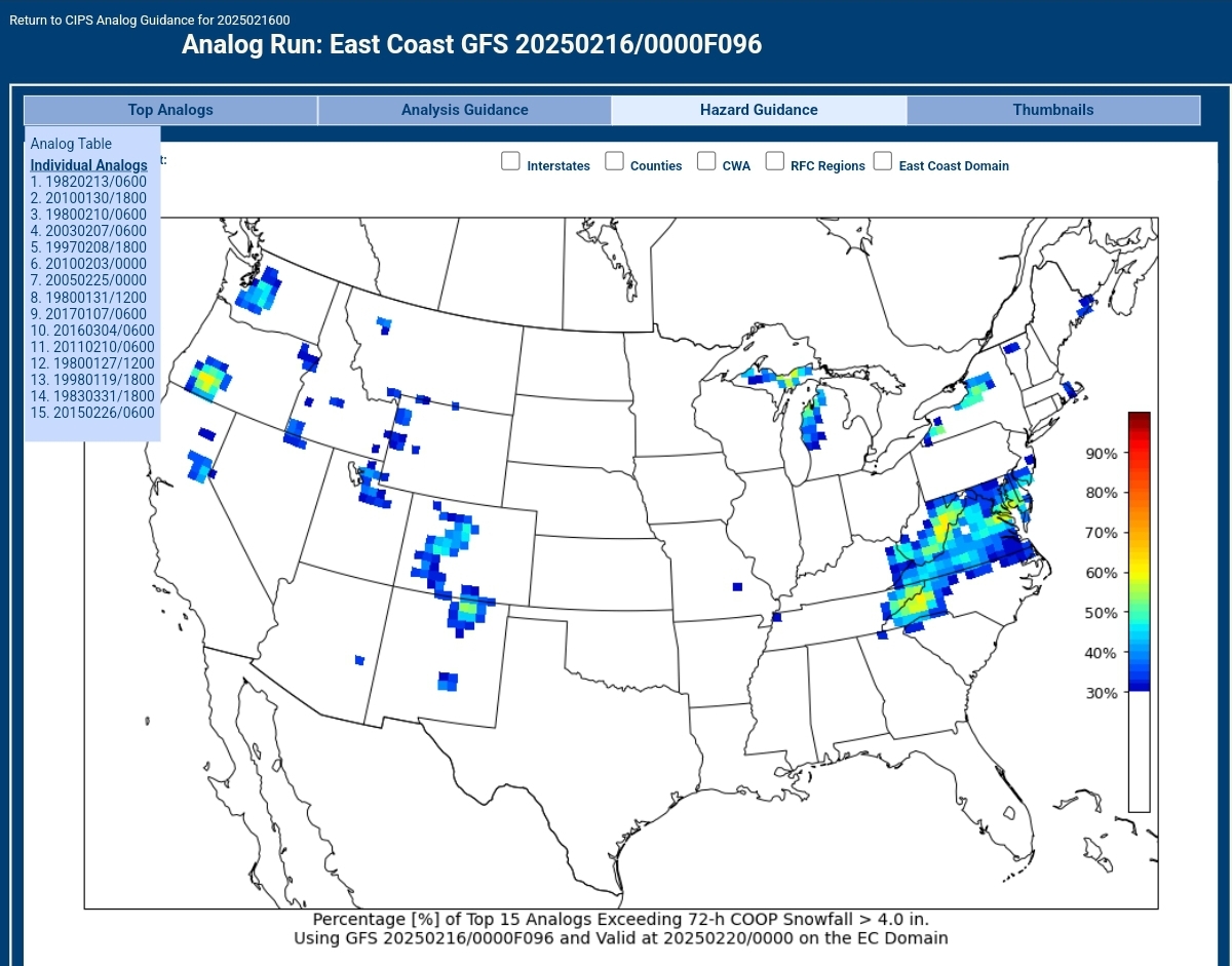
Still a day or 2 away from the best range but here's the analogs from the 0z run. Not bad not great. Hasn't wavered much. Once inside of d3, all ops look mostly the same so analogs become more accurate.

-
I don't waste hard drive space remembering specific bad storms but I always thought a SE miss was a whiff north of EZF and flurries in Wes' yard at best. The infamous VA Beach shellacking with broken clouds in the DMV is another one. If the majority of the sub gets accum snow, it's not a miss or a whiff in my book.
-
There are certain upper level requirements for big ones so when that's in place, models just need a shortwave to work with. When models are locked into a good upper level pattern, any shortwave can set things in motion. Often times during long range tracking, models keep showing big storms but if you follow the shortwave back in time, it's not always the same one but the end results keeps looking the same lol. When models start locking in on the same wave, uncertainty decreases and the wave is often way out in the pac somewhere. Jan 2016 was insane like that
-
Look on the bright side. RIC and SWVA weenies are still lookin solid. I'll let you use my snow total in your yard to help out. It's what friends are for
-
Whew! Allgood. Was a close one
-
I think what we need is someone with a psychology degree to fix that ish
-
12z eps is about a strong of a signal as you can ask for irt a flush hit with waa wall. What a beaut. I'm around 5" from climo snowfall. I hate predicting beyond day 3 but I feel basically all in on a widespread 3-6" with upside. I've thoroughly enjoyed this winter. If next week works out, worst grade I can give the season is A-. Not a blowout snow year (yet) but winter appeal in general has had very few breaks this season.
-
We have an insurance policy for now at least. The WAA piece looks like a flush hit here. Models have nice 850 and 700mb frontogen all over SWVA. That's easy snow and at this point seems very likely we're getting a piece of that. North of us doesn't benefit the same. Areas north need some phasing and rapid deepening of the low. That's more complicated and harder on the nerves. We're pretty locked for 3-6" min I think.
-
Yea, it's a very predictable paradox and why I don't engage like I used to. Misery may in fact like company but I have no interest in miserable company
-
I figured I'd be waiting a number of years for a major storm after I moved south... let's do this. Idga single F what happens north of our yards. All ingredients are in place for a cold start and finish major storm.... I'm starting to feel this one but ready for the nard punch lol
-
Jan 29/30 is the exact analog date showing. I need to dig into the rest. I don't remember much memorable stuff on the list. Just avg storms or the wet not white storms. D3 is the best range for CIPS ime. Hopefully bigger dogs start showing once we get to mon AM
-
One of the most common top 5 CIPS analogs I'm seeing last few days is late Jan 2010. CIPS is run off the gfs so not exactly a broad data set getting fed. Once we get to d3 it's a great tool for setting high/low bars based on history. I do think the Jan 2010 analog is a really good one. That was an awesome cold storm even if a surprise
-
Verbatim the narrow stripe is "scary" but given the upper level setup and the history of our area, it's still a widespread storm and the cmc just burped a little. I can't think of any setups like this (with a turn instead of exit) that didn't cover the area pretty evenly except for the impossible to predict jack stripe. Basically take the cmc jack and smooth it out westward 75 miles and it looks more typical (imo only)
-
If the cmc is the worst outcome I'm still hearing tents getting pitched.
-
I'm most certainly not mad at the gfs lol. A 10" wall of heavy WAA followed by ULL fluff. There is no such thing as an easy foot of snow where I live but the gfs cave got me... I'm all in lol
-
Outside of the few main ateries around here, they really don't plow lol. The cold 4" storm was mostly left to clear itself. Lots of trucks so people just drive through whatever and go. Once a track is packed, cars quickly follow lol. I could do without a 12" storm because it's so disruptive and I'm behind schedule with our project already due to a cold winter. But.... I'm so curious how bad it might be that I'm doom rooting lol. We had a lot of trees come down on the roads this year with the 2 ice events. Unless they hit power lines, local residents are pretty much responsible for getting them out of the way. I always have a chainsaw in the bed of my truck and have stopped multiple times to clean up public roads. So many people do it that roads are rarely blocked for more than a blink. I really enjoy living in an area where nearly everyone is resourceful and has tools to take care of problems on the spot. Having limited public services almost seems beneficial to qualify of life. Everyone does their part quickly without a second thought. Starkly different than my Rockville years lol
-
Looks like the last 2 runs of the euro is the perfect setup to steal a sizeable chunk of happiness right out of a nice snowstorm come gametime
-
Some decent analogs showing up d11+. Late feb/early Mar 1994 being a notable one. Early March 05 as well. As for next week, looks the same to me last few days in general. Cold progressive wave with probably the largest stripe of snow of the year in our general area. I think the SE whiff worries are overblown unless I'm misinterpretation something. Are people fretting the jack or the chance of accum snow in general? If your focused on accum snow, looks pretty easy. If you are sweating the jack, you will prob be unhappy while its actually snowing lol
-
That's the lid I think. It's a tall order to get h5 to close a second low south of the vortex so the setup doesnt support a 1-2 punch storm. Without a vigorous upper low, you can't really get a long duration or moisture bomb. A warning level progressive shortwave is probably best case unless things shift around. Another thing holding back max potential is lack of organization near the MS# River. It's diffuse and flat until approach. One way a progressive wave can produce big is a big moisture fetch/organized low in place in advance. Not the case here. I do feel like there is a very good chance at a warning level snow but anyone married to the widespread 12+" fantasy op runs is either already named Ji or their bubble will burst