Bob Chill
-
Posts
35,956 -
Joined
Content Type
Profiles
Blogs
Forums
American Weather
Media Demo
Store
Gallery
Everything posted by Bob Chill
-
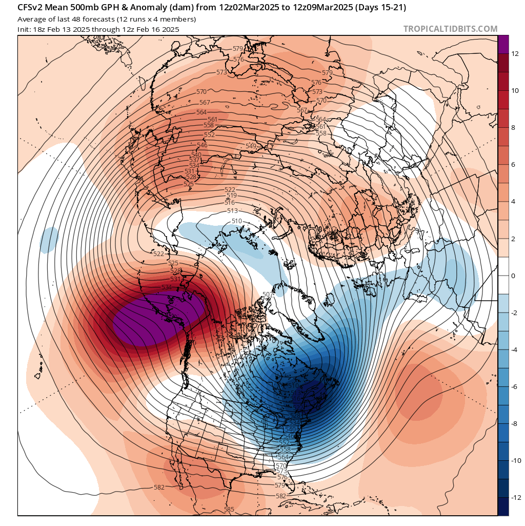
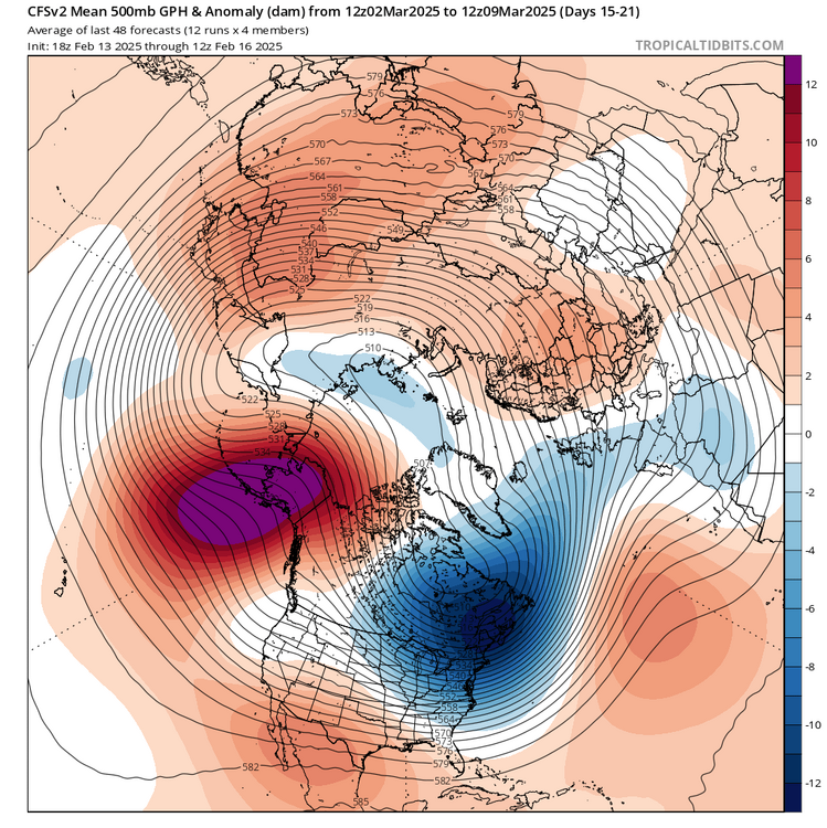
It's a 100% optional hobby.... yea right, my eyes are extra brown lol Honestly, I don't even see a "warmup" of sig consequence. Meaning days of +5-10 strung along are something i see. My gut guess is it will take time to scour the incoming airmass even after the mids warm up. Then a messy period followed by a big storm out west that carves a transient -PNA. We'll be warm last week of feb but staring down a flip to a more typical pattern that can snow on us. Progressive but interesting. That's my call. Let's see what happens
-
Some interesting analogs showing up in the LR. March 2008 and 1994 storms along with Feb 1997. March 08 was of course an OH/western PA deal but it was a big storm. Current analog sets seem to favor a big storm happening in the east half of the country ptype is a different discussion lol but some MA snows are in the mix. Are we sure winter is done and it's time to grade and watch baseball?
-
We'll be tracking a window within a week imho. From what I see, another period of +pna/-epo is possible first 10 days of March and any "warmup" will be under a week. Last blocking collapse evolved into a -epo/+pna so there is precedence. Not the best snow pattern but it's March and things can be powderkeggy
-

Richmond Metro/Hampton Roads Area Discussion
Bob Chill replied to RIC Airport's topic in Mid Atlantic
Similar adjustment on the gfs. May not make a difference this run but these are the things all of us want to see -
Richmond Metro/Hampton Roads Area Discussion
Bob Chill replied to RIC Airport's topic in Mid Atlantic
Nam and Icon both shifted pretty early in the runs. Noticeable improvement with amplification thru the deep south/TN Valley. This resulted in a modest shift in track but more importantly, the gulf tap is better. More juice. That's the easy snow we all need for a decent storm. I'm pretty much out on coastal enhancement but there's a nice path to victory still. If gfs and euro have similar bumps its a great sign as we're in the short range. Those types are adjustments can happen into game time. -
It all comes down to the WAA piece for us. I mean sure, coastal enhancement level ups the storm but I'm already prob too far away. We simply want as much juice as possible and the east way to get it is modest amplification while tapping the gulf.
-
Both the nam and icon hang the tpv lobe back a little opening the door for more amplification before the TN valley. One thing that can help anyone/everyone is the shortwave to accumulate as much gulf juice as possible before approach. That + a modest adjustment in track can make up some lost ground
-
I did express my concerns in the mid range. Even at the height of the runs I was pretty modest. I mentioned several times that a big cohesive storm had some problems but it was overridden with euro snow maps and intense optimism lol
-
No problems posting them or any map. They should all be posted because even fantasy runs are plenty useful in the thought algorithm. Using a 120+ hour map to make your final call with emotions attached and not accepting anything less? That's masochism man!
-
It's a bust overall as it stands now so I'm not saying I expected a complete collapse. Burns me too but I'm used to losing 3-6" storms. Comparing this to Mar 2001? Omg wtf. A memorable bust? Idk man. The only way it can feel that way is if you were sure it was going to be big and locked in. Was it ever really close to that lol?
-
There's a bias in play here. Gfs/gefs was getting ripped when it was weak and disorganized while the euro was going big. It was assumed to be wrong and would catch on to the euro. I looked at if different. To me it was a consistent warning sign that a cohesive storm had some problems. More that one. It seems like a model collapse when consensus showed the northern piece being a thorn instead of a boom. But there were plenty of warning signs not to jump on the boom bandwagon and I never did. Never doubted an OK storm, but those big totals never seemed real to me. I'll say this, this place would be a lot more fun if people would stop marrying mid range high end fantasy stuff. Anything less is unacceptable but less is a near certainty.... time and time again over and over lol. The majority of our storms are looked at with turd colored glasses come gametime because of this. Even when it produces what's expected in the short range.
-
As long as you feel like posting, probably
-
CFS is predicting lions
-
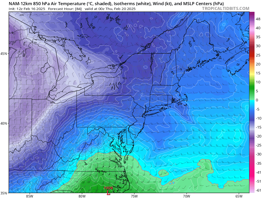
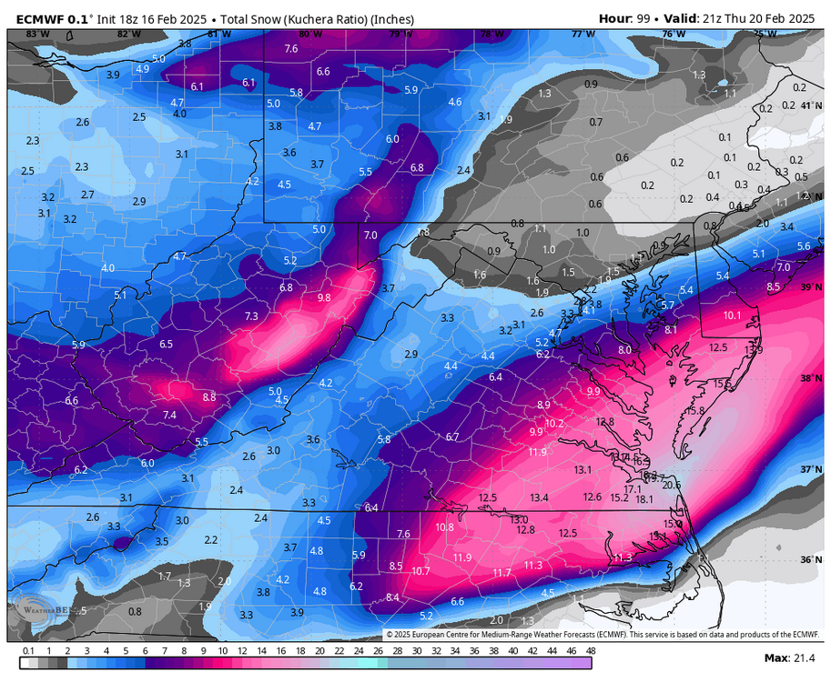
Still locked at 3-6 for us. Wont take much to add a few inches. Increasingly unlikely to lose much. The storm as shown is just a slug of WAA then it shuts off as things get cranking to the east. It won't take much to spread the shield in the dmv area another 50 miles NW either. That's trickier and certainly not something i could guess with confidence
-
Out in mid range, it kept looking to me like a place kicker. Just booting the southern wave out of the way and de-energizing it as it does it. I didnt want to post that it made sense because of the reception it would have had lol. Without the lobe hanging around, the WAA piece would easily stream to DMV. Lift is getting robbed in the dead space gap. We dont deal with setups like this enough to have much precedence. A full blown TPV like 2014/15 is real energetic and lights stuff up. This isn't a tpv like that. It's just a cold cutoff ball with potential energy. I know you know this. Just finishing my thoughts
-
Been the problem since the start. Psu has a great point on h5 prog charts and history but I'm not sure we can call it an ULL. It's a closed cyclonic circ but it's dead as a door nail with energy. If the southern wave didn't exist, the closed low would do basically nothing. We've had a number of waves over the last 10 years that just couldn't hook up with the northern or polar energy. There was always a dead space of subsidence between the 2. Imo, that dead space is there but there is no action with the closed circulation to have enough contrast to show it. My rule of thumb with stream interaction is if it's not helping its hurting. No real middle ground. Seems to me like if they don't play nice together they simply steal from each other. From that perspective, this storm has made a lot of sense to me
-
Mitch is a trip. I remember one night when we hit Dennys after bingo and this big cloud of dust went by and I was like "wtf was that?" And mitch was like "oh man, sorry. I had taco bell earlier"
-
Richmond Metro/Hampton Roads Area Discussion
Bob Chill replied to RIC Airport's topic in Mid Atlantic
100%. Maine too. Thing is, we love snowstorms but being true to ourselves, Iwe don't love long cold dark winters. All my hobbies are outdoors. The work I prefer to do is outdoors. I like to sit on the screened porch every possible aft/eve. The NE is stoopid beautiful in winter but man there are some major tradeoffs. Ones we couldn't stomach. The final deciding factor for us was cost of living. It's shocking how much less it costs to live here top to bottom. Cashing out the rockville house and downsizing expenses/lifestyle allows us to live richly and debt free. We could easily survive on just social security. I did well enough working in MD but we were NEVER free financially. It's nearly impossible even with "big income" whatever that means lol. -
Richmond Metro/Hampton Roads Area Discussion
Bob Chill replied to RIC Airport's topic in Mid Atlantic
I will 100% be posting here more often. I should've all year but old habits die hard lol. I should post in the SE sub too. The main MA sub isn't working for me like it used to. It's not enjoyable like it used to be. Too much underlying tension. You can literally feel it. I love living in swva. Smartest thing I've done in many years. People are so reasonable, helpful, and genuinely nice. Most people I interact with have broad skill sets too. If you took 3 random people out of rural areas around here and put them together, they could build a house from the ground up while building a hotrod in the driveway at the same time. Its awesome. I feel completely at home and in my element. I never really felt that ever in the 22 years in rockville lol -
Richmond Metro/Hampton Roads Area Discussion
Bob Chill replied to RIC Airport's topic in Mid Atlantic
The NAM can often be the first to introduce mix lines where there were previously none. In this specific case it's probably over done. There's an unusual amount of wiggle room in the column but this far south there can never really be enough. However, the nam wreck the column because it drives an 850 low to nearly Pittsburgh lol. Mid levels are a warm air vacuum. Can it break this way? Yes, within the envelope imo. But the nam is a mesoscale model and the storm hasn't even organized yet. So the 84 hour panel is a complete digital evolution. NAM loves to go a little haywire beyond d2 in these situations. If the shortwave was over the MS river and getting organized, I'd be pretty concerned rn but we're not there yet and imho, it's pretty unlikely the NAM is "on to something" yet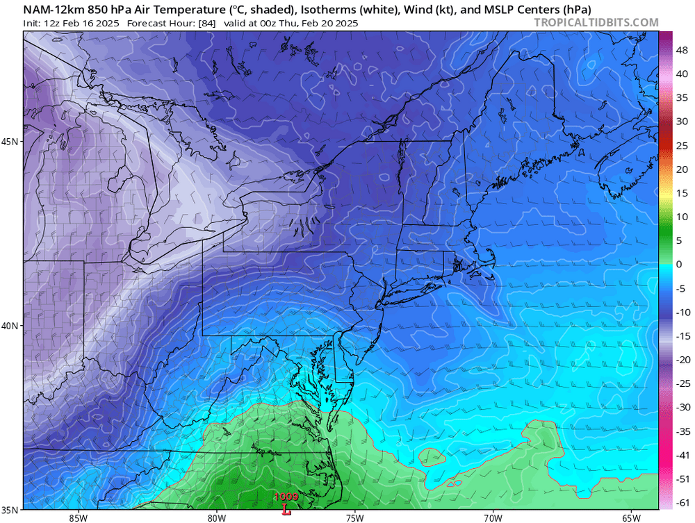
-
Winds are ripping now. Front was just rain but pretty dramatic. Immabout sick of rain lol. Theres flooding all over down here. Especially west of blue ridge. Considering how many weak trees are hanging from last week's ice, the sound of chainsaws will be prolific next couple days
-
Got it. Frank Pee U. it is
-
My parents lived in Cambridge from 07-18. I spent a ton of time there. A run to Salisbury on a hot humid day could bring you to your knees. It's like Ole frank Purdue feeds his birds microwave burritos and PBR
-
NJ is no different. That middle rural section is wild. I have family outside of Willingboro and the pine Barrens. Sophisticated it is NOT lol
-
If Jan 2010 can bump us from zero to hero in the short range, this one can do better. It just needs to make the turn and fiddle around with the polar/northern stream energy. The WAA part is already prog'd more expansive and further north than 2010. Any modest turn exiting the coast prob hits the entire dmv area with a nice storm. Well, "nice storm" as long as you didn't marry the mid range fantasy maulers lol