Bob Chill
-
Posts
35,956 -
Joined
Content Type
Profiles
Blogs
Forums
American Weather
Media Demo
Store
Gallery
Everything posted by Bob Chill
-
Did the sandwich get hurt? You never said and people are concerned
-
We still callin it a wrap?
-
1/20/2016 iirc. Smallest accum snow event to shut down the roads probably ever. It was like an inch and people slept in cars lol. A week later was better though
-
Dam DT. Has me basically on the 6" line. Benefits of living near his bias. I just wish he was right more than once every 3 years
-
I'm a numbers guy too. We avg 12-13" of total QPF during our snow climo window and only 1-3" of it averages as snowfall depending where you live. Call it 15% on avg. That's a warm wet fact . With such a small slice of total precip averaging snow, it's easy to see why it disappears on models all the time cuz mid/lr progs think we avg double or triple that haha
-
Yoda missed one.... sorry peeps, had to do it URGENT - WINTER WEATHER MESSAGE National Weather Service Blacksburg VA 230 PM EST Tue Feb 18 2025 NCZ004>006-VAZ035-043>047-058-059-190400- /O.CON.KRNK.WS.W.0007.250219T1000Z-250220T1800Z/ Stokes-Rockingham-Caswell-Amherst-Henry-Pittsylvania-Campbell- Appomattox-Buckingham-Halifax-Charlotte- Including the cities of Lynchburg, Martinsville, Appomattox, Keysville, Eden, Yanceyville, Danbury, Amherst, South Boston, and Danville 230 PM EST Tue Feb 18 2025 ...WINTER STORM WARNING REMAINS IN EFFECT FROM 5 AM WEDNESDAY TO 1 PM EST THURSDAY... * WHAT...Heavy snow expected. Total snow accumulations between 3 and 5 inches. * WHERE...Portions of north central North Carolina and central and south central Virginia. * WHEN...From 5 AM Wednesday to 1 PM EST Thursday. * IMPACTS...Plan on slippery road conditions. The hazardous conditions could impact the Wednesday morning and evening commutes. PRECAUTIONARY/PREPAREDNESS ACTIONS... If you must travel, keep an extra flashlight, food, and water in your vehicle in case of an emergency. The latest road conditions for the state you are calling from can be obtained by calling 5 1 1. &&
-
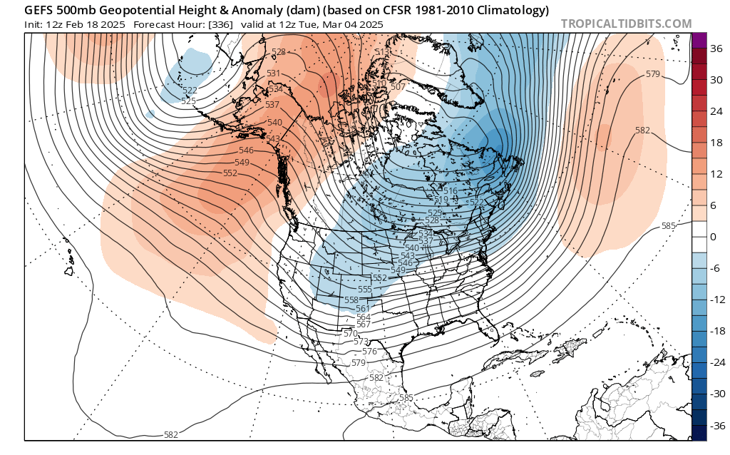
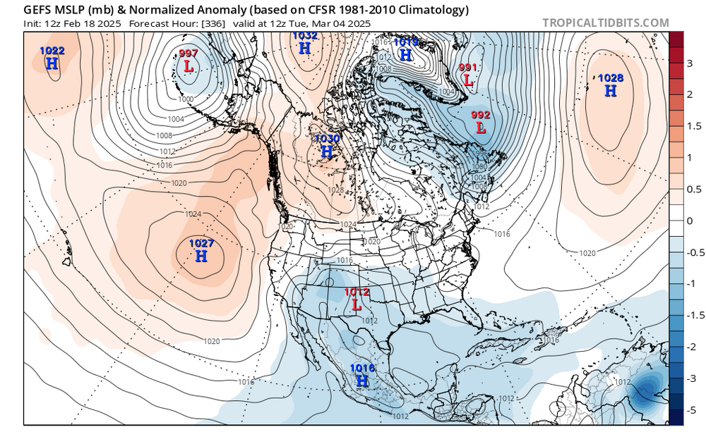
Gefs is pretty good for the Mar 4-8th window. Southern rockies > deep south > MA... I'm kinda feelin this one too. Not the specific gfs idea. Just that it's coming, won't take forever, and will be keeping us up at night soon enough. Gefs just looks dang good considering


-
More than once and that's enough.... allllll in
-
Absolutely the same. Train tracks isn't the best word because the repetitive nature isnt just storm tracks. Areas can make up for lost time quickly in all categories but they way it happens is through a variety of events. It's more like a magnet than train tracks because that implies the same exact type of storm keeps happening. I've believed in it for over a decade and use it as a predictive tool. It won't always show up on h5 progs. It's more of a personality thing vs nuts and bolts. Stark examples are drought busters. All of a sudden it's time. Why and how I don't know but when switches flip they mean it. The lake Powell recovery (still bleak but last few years weren't supposed to happen lol) captures what I'm talking about. It got all kinds of unusual boosts including tropcial. There are cycles in cycles on longer timescales. Imho, and I've said this before, I don't think the last 8 years are a new anything. Meaning "sudden new normal". It was just a typical (with precedence) MA "anti-heater". Other than the 60s, there are examples in every decade. I'm not arguing that we're losing on the margins from temps. I just never once believe that we won't have strings of acceptable and normal winters. It was a big part of my confidence making a call against the grain this year. It was time and I guessed right. Intuition is telling me this year is our heater (or acceptable) kickoff year and the next 6-8 years will look pretty decent when it's all said and done. Not without a gnarly dud or 2 but it will not look or feel like the last 8 years on paper. There's my Uber long range call. Hope I'm alive for verification Lastly, I also strongly believe the EC (including us) will have a record breaking snow storm in the next 10 years. Warmer temps hurt us on the margins but def help us with intensity and qpf. I'm def not a Deb over our long term prospects. We just have to deal with a warmer planet like every other living thing on it
-
See ya every 6 hours thru mid March brother. It's coming
-

Richmond Metro/Hampton Roads Area Discussion
Bob Chill replied to RIC Airport's topic in Mid Atlantic
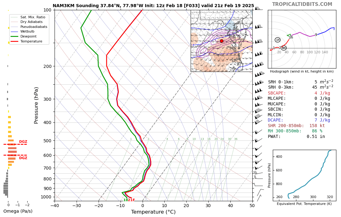
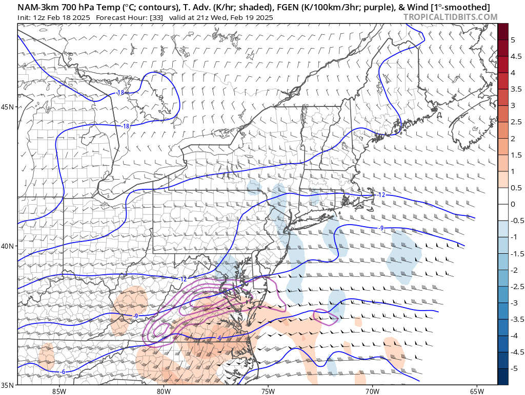
Just checked the soundings to go along with the 700mb fronto plot. Someone is getting hit pretty good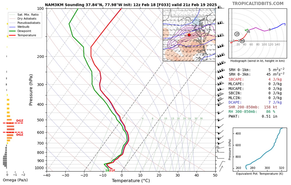
-
Richmond Metro/Hampton Roads Area Discussion
Bob Chill replied to RIC Airport's topic in Mid Atlantic
3k nam likes RIC area for best lift during the WAA piece right as coastal enhancement starts taking over. That same area of lift helps me too and sends some crumbs back out here for a touch of coastal enhancement. Stronger/juicier wave leading in = broader coastal enhancement ETA: I'm not versed in RIC (or my own new climo lol) with the subtle stuff but one of my personal rules of thumb with WAA snow is the northernmost cohesive band of heavier precip usually has a localized maxima in real time that models don't do a great job at getting right even at very short leads. North of that line is diffuse flurries and subsidence. Sweet spot just south usually has great snow growth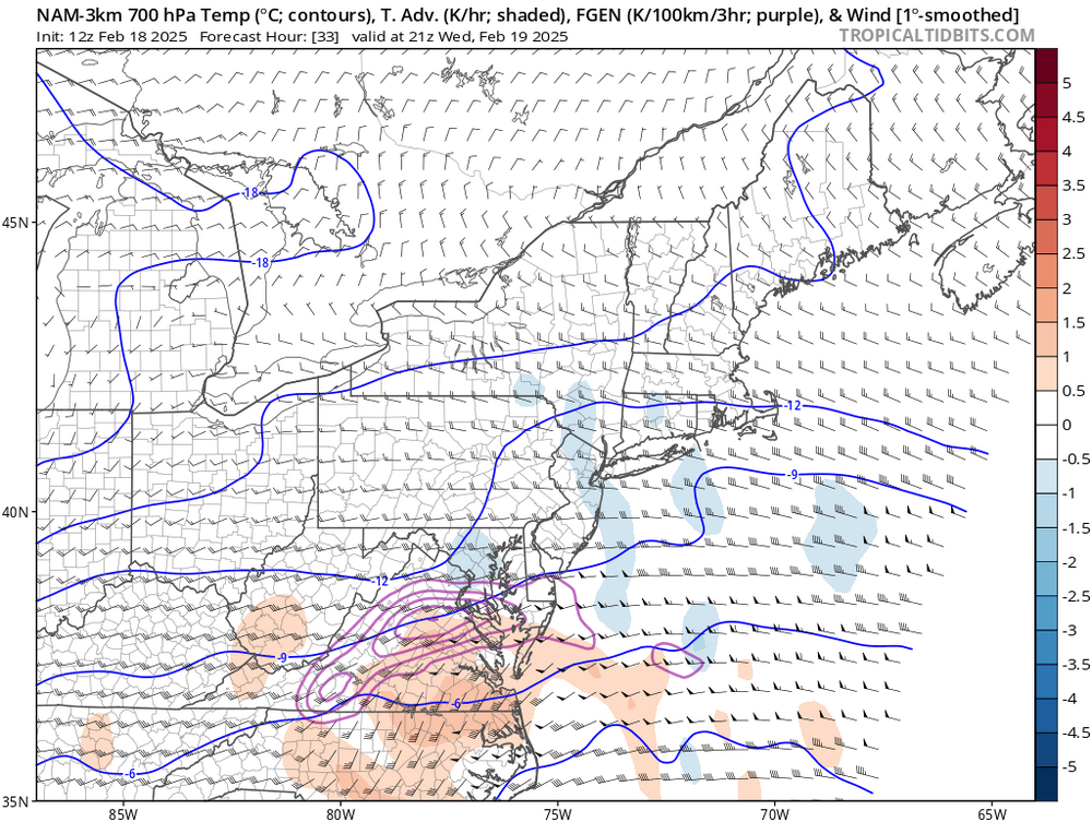
-
Richmond Metro/Hampton Roads Area Discussion
Bob Chill replied to RIC Airport's topic in Mid Atlantic
We're benefitting from the shortwave gathering more juice as it rounds the base. Changes at short leads are more subtle but check out 6z vs 12z gfs in the deep south. Area between the gulf low and boundary qpf maxes is more robust. This is at 24 hour leads. I need it more than you guys but keep stuffin the h20 molecules please lol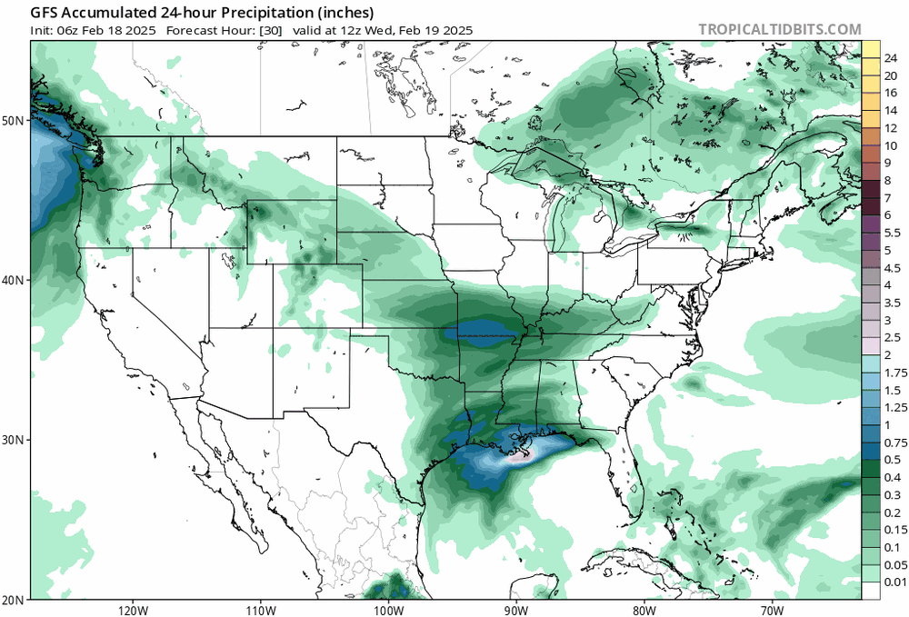
-
Agree 100% on that. We had some of this stuff happen in feb/Mar 2015. After the Vday mini blizzard, the tpv didn't leave our proximity for weeks. Couple progressive waves similar to this one got pac man'd to hell. One psu and highstakes will remember well. The cold dry air tore an arc out of the nw side so on paper it had the same vibe. That was a weird underperformer too. It was too cold and dry. Radar didn't reflect reality much. Heavies were light. Snow quality sucked at times. Ground up flakes and sand. I worry a little about that tomorrow. Wouldn't come as a shock to get sub 10:1 on whatever qpf falls. 850/700 frontogen panel are pretty meager until you get towards RIC
-
Lol. There's not much difference there. Just don't talk dmv fast lol. Wife and I love it here. Everything is amazing. Nice helpful people, no bs, fair cost for any service, low cost of living, and the scenery is off the chain. I traded 5" of climo so to do it and I'd prob trade a few more if I had to lol.
-
It's really not a Miller B. If anything its a pure coastal Miller A. It's just getting hammered by cold/dry/un-energetic air on the NW side
-
Icon is a modest but visible step towards a more amplified storm. Hard to hate it no matter what the yard panels look like
-
Enough guidance gets the back edge of coastal enhancement over me that I 100% want a more amplified and developed system. It can only help me. I've been thinking 3-6 for like a week. No reason to change my mind but I do believe my chances (as they stand right now) favor the higher end of that and it may come a little easier than I first thought. Pretty cautious though. This entire evolution has been tough to figure out since d1 too Eta: my bust bar is sub 3". That would be pretty lame for an 8-10 hour event lol
-
Probably something that doesn't taste like hotdogs
-
ICON is unusually important for trends. You'd think consensus would narrow sharply over the next 2 suites
-
During March, as long as Canada isn't torching, all we need for snow is a +pna. It's not easy snow without other stuff but simple continental cold and a decent trough axis can get it done. Down my way I need things pretty anomalous to get the column right but the nova/md/de zone can get it done without anything crazy. March is cutoff season too so a cutoff bowls into an OK antecedent airmass works too. I don't see any classic big storm stuff but imo, from what I'm seeing, odds def favor another accum snow event (or more) versus flipping the switch and swatting mosquitoes
-
Kuchera is going big on ratios. 10-1 is 2-4 and in line with most other guidance. I'd say qpf is very believable. Not sure about 15:1 but if high ratios are going to happen, column is as good as it gets. Flakes gotta be big and fluffy. Ive seen totals end up low with cold storms before when snow growth is weak and flake quality is closer to sand than pillows. Time will tell
-
Rumor has it that Jebman is already there walking all 800 miles on foot with his extreme duty shovel and a Walkman cassette player. Listening to ELO probably
- 873 replies
-
- 10
-

-

-

-
We could start another thread but we may end up losing snow that already fell earlier this year
-
Welcome and yes, models bust weenies everywhere. They do no discriminate. Places further north bust different because they are often all snow no matter what when cold air is entrenched so it becomes a QPF game only which is still filled with pkenty of uncertainty and frustration. Mixed events or areas where mixed events are typical climo, it adds another very large and complicated bust factor. Very very large. Some around here like big busts though.