Bob Chill
-
Posts
35,956 -
Joined
Content Type
Profiles
Blogs
Forums
American Weather
Media Demo
Store
Gallery
Everything posted by Bob Chill
-
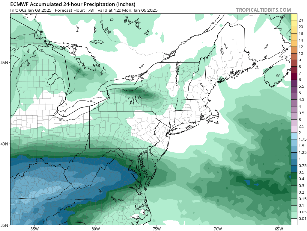
Just for the mental exercise and curiosity, I checked soundings on the euro for smith mtn lake area. I don't lose the column until 12z Monday and over .75 liquid falls. Obviously grape nuts are hitting pretty good by 12z but sounding says all snow at 9z so idk? Am I going to back my way into this? Lol Eta: just realized it's the 6z run. TT is slow lol. 12z prob stole all my snow

-
What a sweet south trend. Just need to keeps the ticks tickin How do you like me now? Hahahaha
-
We gotta wait until the real cold comes and bullies southward over the next 1-2 weeks. It's probably a bit of a bonus check getting any winter wx on the front side of this impending cold period. Ens means D10+ look half decent for southern storm. Unfortunately we probably have to root for a Miller B or slider of sorts that people north of us won't like too much.
-
@WEATHER53 Wanted to answer your question. We sold our Rockville house in early September. All pre-planned over the last 4 years or so. We've wanted out of HCOL MoCo and unfriendly crowds for a decade but kids, schools, and all that jazz doesn't allow life to be simple lol. We chose the general Smith Mtn lake area because it's a recreational paradise with minimal cost of living unless you want a lake front McMansion. Everything is a fraction of the cost and we downsized so financial stress is gone. Which is massively important because that stress was stealing years from me in MD. We have a 25 acre tract of land in a remote section of Pittsylvania County with Leesville lake access. We also have a simple little place in Penhook with Smith Mtn lake access that serves as home base for now until we build our home on the land. The 2 properties are only 3 miles apart with a helicopter but a 20 minute drive due to topography and minimal roads lol. Snow climo here is basically Roanoke so a downgrade there. I've stopped caring about that. Too many factors offset it and I've spent enough time chasing ghosts hahaha
-
Doesn't seem to matter what models do for me lol. Same outcome. Getting interested in the zr. Lots of pines on the mountains and hills here. Could look pretty cool iced up after an inch of snow at best. Not that it makes any damm difference but I'm rooting for @stormtracker, @Deck Pic, and all the other folks who literally get edged every damn storm. Make sure you rub it in REAL good if it happens
-

January: Medium/ Long Range: May the Force be with Us....
Bob Chill replied to Weather Will's topic in Mid Atlantic
Our land ranges from 650-825. Top of smith is 2k. You can drive the entire length of the top on a 4wd trail. Not dangerous. Just need 4wd and good ground clearance. End of banter. Gfs looks good for u guys. Me nasomuch lol -
January: Medium/ Long Range: May the Force be with Us....
Bob Chill replied to Weather Will's topic in Mid Atlantic
Lol nah. I downgraded snow climo with no regrets. Living down here is too sweet to care. Just chillin on the deck waiting for the slopfest one of these days Smith mtn will get shellacked and i will be sure to remind you daily hahaha
-
January: Medium/ Long Range: May the Force be with Us....
Bob Chill replied to Weather Will's topic in Mid Atlantic
I'll embezzle the icon no problem. 2-3" snow, lots of grape nuts, then zr finish. 1" liquid. The 3 county plow trucks would be busy lol -
January: Medium/ Long Range: May the Force be with Us....
Bob Chill replied to Weather Will's topic in Mid Atlantic
History and climo favors the DMV general area but the setup is similar other more rare southern hits. We haven't had blocking and confluence like this in a long time but we've had plenty over the years. Stuff can get bullied south without much fanfare -
January: Medium/ Long Range: May the Force be with Us....
Bob Chill replied to Weather Will's topic in Mid Atlantic
Nice to see ya back Mitch This is where perspective is important. 50-100 mile shifts are really tiny on a global model but make or break on the ground lol. These narrow WAA stripes simply cannot be nailed down yet. Models are narrowing the spread but even 50 miles 48 hours in advance is a small shift. Unless things blip out, I don't want to hear models are all over the place because they aren't even close to that rn lol I'm still stuck on my initial gut feel down here. Hopefully an inch, a boom at 3", and mixing is a near guaranty lol I wouldn't discount Lake Anna jacks or that general area. This is the exact kind of setup that has jacked them in the past. The northern edge is going to be sharp AF too. Pac man will be chowing down -
January: Medium/ Long Range: May the Force be with Us....
Bob Chill replied to Weather Will's topic in Mid Atlantic
I feel quite confident that this general LW pattern will insert its influence for 4-6 weeks. Certainly not foot to the floor the entire time but just never getting too far out of whack and a propensity to look like the above prog on the balance. A good analogy with models would by JFM 2014 and 2015. Lots of breakdowns that never happened. The tracks have been set imo. Maybe we get a big relax and reload but my money is in this general theme until poof in real time -
January: Medium/ Long Range: May the Force be with Us....
Bob Chill replied to Weather Will's topic in Mid Atlantic
Let's do this S. 4 wheelin in a foot of powder to a hiking trail then giant bonfire and fireworks at night. -
January: Medium/ Long Range: May the Force be with Us....
Bob Chill replied to Weather Will's topic in Mid Atlantic
No matter what happens, the WAA piece looks pretty good for the MA (somewhere) not including my yard lol. Things get muddy with the mid and upper lows but that front part has all the ingredients in place for a hot and heavy stripe. Prob not real fluffy though unless mid/uppers crank a little when mid level winds shift. Not feelin too excited here. Maybe an inch or 3 at best before inevitable ptype problems. Pretty good cad area here though. Especially on our land east of Smith mtn. NE surface flow banks up pretty good and the topography between Smith mtn and Gretna is a forrested bowl. Doesn't scour easy as all. Considering this is my 3rd winter spending time here and I've never seen a plow or the grass covered.... I'll take what I can get and be happy AF. -
January: Medium/ Long Range: May the Force be with Us....
Bob Chill replied to Weather Will's topic in Mid Atlantic
Yessir Closed on Rockville in early Sept. Traded 3" of climo heading SW but it will never bother me. I'm done with cities lol -
January: Medium/ Long Range: May the Force be with Us....
Bob Chill replied to Weather Will's topic in Mid Atlantic
In this case im rooting for something you dont want lol. When I moved down here I knew things would get testy at times with storm tracks lol. I have to root for something different sometimes or often. I mean I 100% want you to get some snow but you know how it goes... it's a backyard sport and avocados taste better here -
January: Medium/ Long Range: May the Force be with Us....
Bob Chill replied to Weather Will's topic in Mid Atlantic
Im totally good with suppression -
January: Medium/ Long Range: May the Force be with Us....
Bob Chill replied to Weather Will's topic in Mid Atlantic
How we lookin? Pattern imploding and dry AF? -
January: Medium/ Long Range: May the Force be with Us....
Bob Chill replied to Weather Will's topic in Mid Atlantic
Didn't take long for Christmas spirit to wear off. Couldn't even wait until the day ended January's are rarely wet months when it's cold. It's the lowest pwat time of year. But it can't snow without cold as we are reminded of continuously lol. 77 and 85 analogs are good in my thought computer. I'll take guaranteed cold over guaranteed precip on any long range look then let the details shake out nowadays. Precip has been overperforming in numerous ways last handful of year. I'll let the thermodynamic peeps explain why lol. Perfection is not a thing we do here. Even when it shows up its no guaranty of anything. Our area rarely walks out of a cycling cold period without some fun. Let's get into the cycle before canceling it maybe? Lol. -
January: Medium/ Long Range: May the Force be with Us....
Bob Chill replied to Weather Will's topic in Mid Atlantic
Downstream effects of the storm that hits between the 31st-2nd is the catalyst to getting the upper levels right for colder souther tracks. Gotta wait for full resolve of that feature before really knowing anything down the line. It's going to get cold and favorable down the line. That seems very likely now. Individual impulses down the line aren't really predictable in any way yet. The way I look at things, the evidence of active flow beyond the 1st is good enough for me. What when and how is still shotgun mode. Won't be long before we know which fail scenario seems most likely lolol. -
January: Medium/ Long Range: May the Force be with Us....
Bob Chill replied to Weather Will's topic in Mid Atlantic
Imo only (and @psuhoffmanmentioned something similar), expected results based on enso climo aren't working anymore. It started after 2016 and hasn't really stopped lol. Since extended products rely heavily on long term enso climo, they have deemed themselves unreliable in all directions. Sometimes they nail it but there's been a lot of dandruff piling up from all the collective head scratching lol. When I did my wagging in October, I had been thinking about this a lot. For a couple years really. That's the primary reason I went against the grain. Not because I'm smarter than weather lol. It just made a lot of sense in the thought computer after being quite wrong for "weird" reasons last 3-5 years. -
January: Medium/ Long Range: May the Force be with Us....
Bob Chill replied to Weather Will's topic in Mid Atlantic
Kinda hard to identify windows/threats until the storm around nye/nyd that all guidance agrees on in some fashion moves through and down stream. Blocking is building before that but from what I see, that storm is what solidifies blocked flow. I've seen a lot of fantasy ops showing both a closed epo and nao ridge concurrently. Ens def support the idea centering the highest mean height in the same places but I honestly can't remember seeing dual features like that in real time. Will be fun to watch happen. These are the types of features that can run a cycle and not hit and run. My gut says it will be a cycle and it will probably run 30-45 days. Plenty of history there but gotta get started first before worrying about how long lol. I really don't see any chance of a storm before the 5th of Jan so I'm not going to get involved in any discrete talk unless it's mid range. I do see a storm window developing between the 5th-10th. Lots of little clues showing up and it fits how blocking cycles usually play out. You know.... rain then cold and dry then maybe a little sumpin sumpin. It's prime climo for flawed setups. Especially west tracks. With @ 50/50, cold highs don't run away. They just hang and rot. Perfect for CAD stuff. Get a good track and you have northerly mids feeding instead of southerlies scouring. We may fail in every direction but I've become pretty confident in some accum snow not too far away. We'll wait and see as always -
I prefer Climax gradients. They're more fun and I live just north of it lol
-
Gotta chain up before the grade to Mt PSU or get a ticket bro
-
Once we get into Jan, thumps to dryslot/west track work here (and waaay down here hi!) without a -30 airmass needed in advance lol. While not ideal, who cares because ideal works less than a third of the time anyway. Even that might be a stretch too lolol. Imo only, if ensembles are right....., early Jan is a heater pattern for the MA. Doesn't mean big storm but small stuff in succession is the next best thing
-
I like everything I see right now but no cold and no snow (for nearly 3 years lol) makes bobchill go something something.... Imo- as depicted, it's not a dry pattern and sets up the gulf/TN Valley connection. Broad bowl shape trough with blocking. Has the 8:30am-2:30pm trajectory look to me. I'm not sure further north than say Philly should like this setup except for cold. Not a big storm look up north and 3-6" only makes SNE'ers angry, apparently lolol. It's also not a nina pattern. There has been minimal classic Nina stuff at all so far imo other than NS activity. NH flow hasn't followed the rules and continues to look like a rebel. Current ens guidance looks like a nino lol