Herb@MAWS
-
Posts
2,157 -
Joined
Content Type
Profiles
Blogs
Forums
American Weather
Media Demo
Store
Gallery
Everything posted by Herb@MAWS
-

Feb 22nd/23rd "There's no way..." Obs Thread
Herb@MAWS replied to Maestrobjwa's topic in Mid Atlantic
Lived in McLean for 8 years a bit south of Great Falls Park. Snow did seem to accumulate well — and better — there. Always enjoyed drive home from work in DC heading north up GW Pkwy to McLean/Great Falls, enjoyed watching how the snowpack got better the further up the Pkwy I got. DC green, McLean white. -
I’m at T-minus 3 hours until Indian Restaurant and some Taj Mahal.
-
Just recently back from the island of Culebra, PR. Last PR island east of mainland PR, before one heads east toward St. John/USVI. We had sunny days 85/ mornings 75.
-
0.64” with latest rain.
-
Feb 22nd/23rd "There's no way..." Storm Thread
Herb@MAWS replied to Maestrobjwa's topic in Mid Atlantic
And it t ain’t over until the fat lady sings. -
Feb 22nd/23rd "There's no way..." Storm Thread
Herb@MAWS replied to Maestrobjwa's topic in Mid Atlantic
If you end up being 2-4”, you may be kicked out of bed. ———- Oh, and only a high of 44 today, imby Columbia, felt chilly. But now at 43 it feels good outside. -
Monday a.m. low 34. 0.50” rain on Sunday.
-
My Columbia Sunday morning low 33.3 Current 7:30am Sunday 33.8
-
imby/Columbia: Overnight Fri/Sat a.m. low 20.9 6am temp 22.9
-
A surprisingly low 33.5 for hi temp today. Down to 27 at 8pm. Looks like good night to see some stars from deck. Modtly clear, moonrise not until sometime near/before dawn. Been noticing how smooth the top of the snow still looks. No footprints. This stuff was/still may be a challenge to walk on and play in up until now, but tops seem finally to be softening some now with warming … plus that increasing sun angle.
-
Hi temp Friday imby/Columbia was only 33.5. Thought I’d do better than that today. Felt ok with no wind. Low this morning 20.4
-
My local NWS forecast/Columbia has 60% chance rain and snow later Sunday. Low temp Sunday night 33. Of course no accums.
-
Flew outta town to the Caribbean 4 hrs before snowstorm began. Returned 10 days later. Today, another 8 days later, I was finally able to get thru the snowcrete and shovel my front walk. Tough work !
-
30.1 my morning low. Heatwave …..
-
High 39 today imby in Columbia.
-
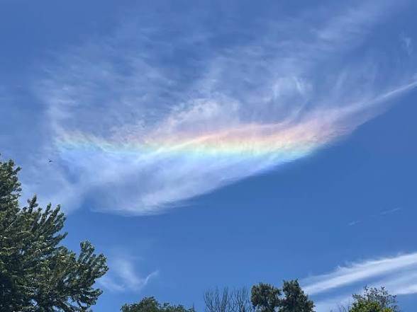
Rainbow clouds are fun. Not rare but a bit uncommon. Ice crystals acting like prisms in high-up clouds. Have used a pic of some I took over my house as my laptop wallpaper for 15 or more years. Not this one shown altho it looks similar. The pic I took is on my laptop upstairs but sending this from my phone from the basement. Not necessarily my fave, just something a little different. Saw one a few days ago while in Culebra.
-
Monthly Rainfall imby, Columbia; Nov 1.63” Dec 1.59” Jan. 2.01”
-
Columbia 8 at sunrise imby.
-
Going with 0.4” imby. Bona fide car topper yesterday evening. The first big frontal wind gust blew it all off the cars.
-
Fixed. Caught flu at midnight from sick grandson. Up all night. Been sleeping all day. What day it is … is rather irrelevant to me at this point.
-
Columbia pixie dust 31° 3:45pm Friday.
-
Yeah, the cold got real south. Was in San Juan for a week. Even there yesterday the “chilly” high was 76 while, plus/minus 85 rest of my week. Weird Feb day for them. Off and on heavy tropical-like rain. 3” in general, 6” in spots. Interesting reading the NWS Office’s daily AFDs to see the unique factors that make up their forecast. They’ve been talking about the side effects from our cold airmass. Rained so bad I couldn’t fly island to mainland yesterday.
-
I’m in Culebra, Puerto Rico for a week. 79 at dawn today. 86 in afternoon.
-
79° at 8am on island if Culebra, Puerto Rico, high of 85 today. So sorry to miss this storm. I fly home late Monday so I’ll be lurking for best info possible to see what the weekend brings. Not expecting travel issues right now, but plenty of time for things to change.