

Wxtrix
-
Posts
26,403 -
Joined
Content Type
Profiles
Blogs
Forums
American Weather
Media Demo
Store
Gallery
Everything posted by Wxtrix
-
if you're chasing to Thurmont, you need to eat at Chubby's.
-
Advisory: Winter Storm Watch until 07:00PM Saturday Dear Nixle User, * WHAT...Heavy mixed precipitation possible. Total snow accumulations in excess of five inches, and ice accumulations in excess of one-quarter of an inch are possible. * WHERE...Portions of western Maryland, central, northern, and northwest Virginia and eastern and panhandle West Virginia. * WHEN...From Saturday morning through Saturday evening. * IMPACTS...Plan on slippery road conditions.* AFFECTED AREAS: EXTREME WESTERN ALLEGANY ... CENTRAL AND EASTERN ALLEGANY ... ROCKINGHAM ... SHENANDOAH ... FREDERICK ... PAGE ... WARREN ... CLARKE ... GREENE ... MADISON ... RAPPAHANNOCK ... NORTHERN FAUQUIER ... WESTERN LOUDOUN ... NORTHERN VIRGINIA BLUE RIDGE ... HAMPSHIRE ... MORGAN ... BERKELEY ... JEFFERSON ... HARDY ... WESTERN GRANT ... EASTERN GRANT ... WESTERN MINERAL ... EASTERN MINERAL ... WESTERN PENDLETON ... EASTERN PENDLETON
-
38/22 with flurries
-
i still have hope.
-
models don’t predict. people do.
-
i’ll enjoy these point and clicks while they last: Snow likely before 1pm, then snow, possibly mixed with rain. The snow could be heavy at times. High near 35. Chance of precipitation is 100%. Saturday Night Snow likely, mainly before 1am. Mostly cloudy, with a low around 29. Chance of precipitation is 70%.
-
https://thecloudonline.net/blog/basic-skew-t-analysis-snow-or-no-snow/ there are dozens of sites out there, depending on how in-depth you want to go.
-
did she ask us to write it, or you?
-
i thank the gentleman from North Baltimore for his support.
-
i move that everyone is henceforth required to use the description “Mason-Dixon Line” when discussing the snowier areas north and west of the cities.
-
all of the signals have been solid out here for almost a week now--I'm starting to get optimistic.
-
12" ribbon in my back yard. it's nice to dream about.
-
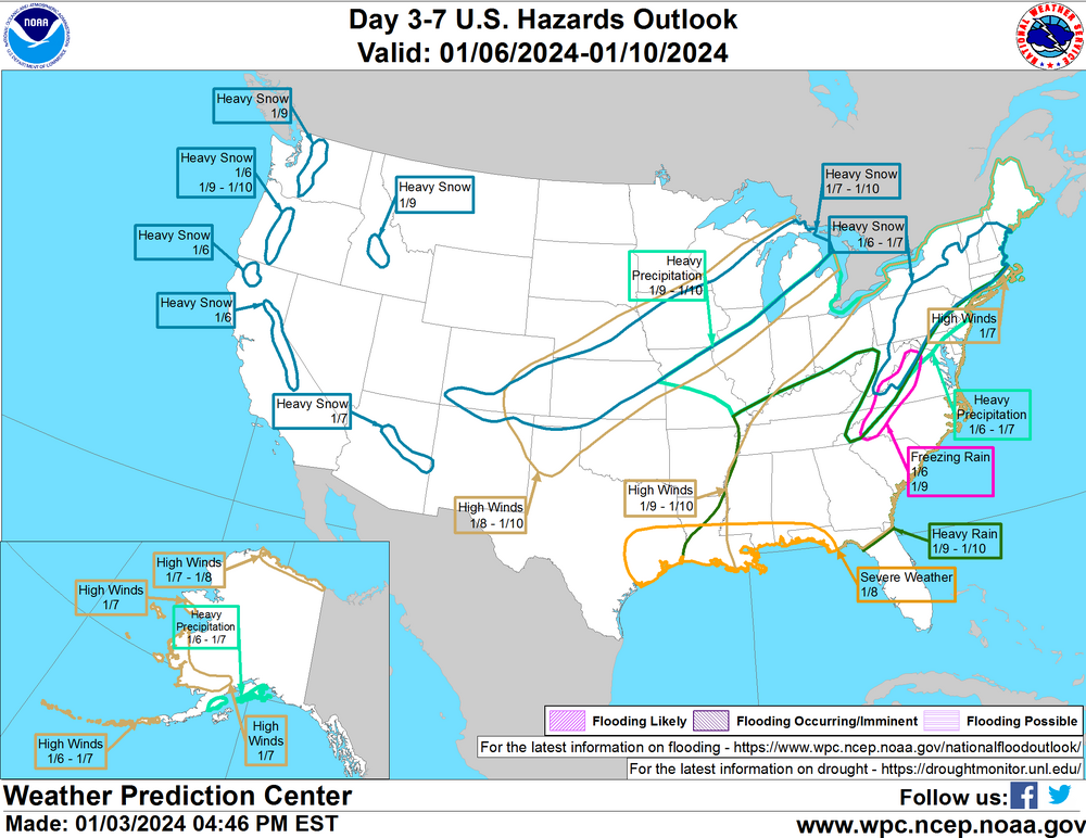
so far the storm is matching up with the NWS experimental products from the end of last week that showed areas west of the Blue Ridge getting the bulk of the snow.
-
imagine being mad that a model “gave me less snow”. NONE OF IT IS REAL.
-
i wish object permanence could be taught.
-
i think you did. or maybe i’m connecting you with your other name, if that’s what you used? same difference.
-
i remember you from eastern.
-
he said something really crude to a female poster. he was always crude toward women here, including me, and I celebrate his permanent absence.
-
he's banned.
-
fwiw, I'm interested in this storm. it's been a while.
-

Jan Medium/Long Range Disco: Winter is coming
Wxtrix replied to stormtracker's topic in Mid Atlantic
i wonder if anyone else saw this on Friday: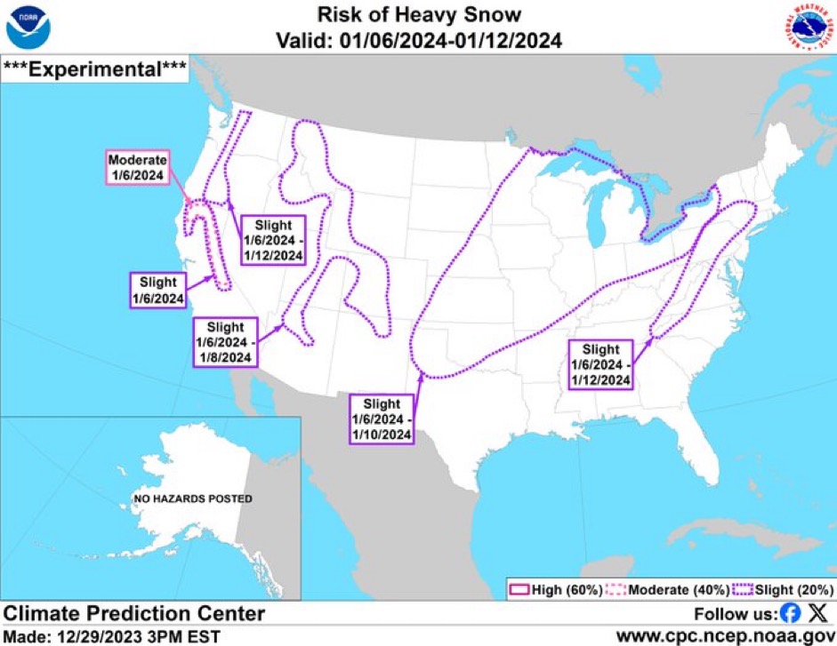
-
flurries here
-
a dusting on roofs, cars, and grass that melted at dawn.
-
-
Virginia Department of Environmental Quality has issued a Code Red Air Quality Action Day for Fine Particulates for Augusta, Clarke, Frederick, Nelson, Page, Rockingham, Shenandoah, and Warren Counties until midnight EST tonight. Code Orange to Code Red air quality is also forecast over Berkeley, Jefferson, and Morgan Counties in West Virginia. An Air Quality Action Day means that Fine Particulate concentrations within the region may approach or exceed unhealthy standards. For additional information, please visit the Virginia Department of Environmental Quality at: www.deq.virginia.govalertCTAsDict* AFFECTED AREAS: AUGUSTA ... ROCKINGHAM ... SHENANDOAH ... FREDERICK ... PAGE ... WARREN ... CLARKE ... NELSON ... NORTHERN VIRGINIA BLUE RIDGE ... CENTRAL VIRGINIA BLUE RIDGE ... MORGAN ... BERKELEY ... JEFFERSON


