Bxstormwatcher360
-
Posts
484 -
Joined
-
Last visited
Content Type
Profiles
Blogs
Forums
American Weather
Media Demo
Store
Gallery
Everything posted by Bxstormwatcher360
-
Shhhh don't tell nobody!!..they still playing catch up.
-
34/26f here at the cave. Snow smell in the air.
-
The radar is starting to really pick up now. Alot of low level moisture with the onshore flow. Some good banding should start to develop soon.
-
Thanks. I was being sarcastic but it is snowing pretty gd acc to radar.
-
I mean its nowcasting time anyway, if you look up rn..its a frighin snow sky. Its dark n grey and it feels like a storm is coming. I just watch it evolve!!. Today i can actually enjoy some snow right before christmas. No need for debbie downers of which there are many on here.
-
Can anyone confirm if hingham is getting peter rolled rn??..that band looks like a lake effect band.
-
Maybe but i am a winter born human being,so i root for snow any day of the week in winter. which obviously doesnt happen much.
-
Its all good..a cup of coffee will fix that. But yeah this look will not be the final result,theres no snow where the ivt would be modeled either.
-
Thats the 0z..your only 6 hours off amigo.
-
Snowman is actually the raingod on this forum so i doubt he prayed to him.
-
The atmosphere is juiced already,whatever echos pop up produce falling precip it seems. Thank the atlantic ocean for that.
-
We are the only ones harping on that trend, they might be playing catchup in a few. Precip now entering eastern l.i off the ocean.
-
There's bust potential with this forecast. Who gets the ct river valley screwzone is the real question?
-
Your right but i mentioned that with l.i in mind. The easterly fetch is bringing in the mousture for eastern areas which wasnt mentioned at all. I think we get some decent bands later on in any case. The squeeze play is on.
-
Well its snowing in parts of coastal mass due to ocean effect and echos breaking out to our south east and west. Im not the most astute meteorologist but from the eyes it def looks west.
-
Another tick west for both the nam and gfs 6z suites. Nyc east gets into the main precip shield for a bit now,followed by the ivt. Also of note is the precip running up the delmarva coast currently.
-
Ocean effect snow with a easterly flow. Might bode well with the coastal itself,looks like it may be coming west of modeling.
-
Basically it's ticking west every run.
-
Precip already breaking out in eastern nc,usually foretelling of a coastal forming right on or just off the coastline. 0z suites already picking up on that .
-
Its gonna snow in nyc.. it might a dusting or 4 inches..but its gonna snow.
-
Of note ,we are due for a clipper bomb around these parts. When i was younger clippers always enhanced appeaching the ocean,throwing back moisture. Now they barely get flurries across the app mountains stage right.
-
Im actually on board with this, also look at the clipper now,looks pretty robust atm,as it transfers energy,its gonna bomb. Somebody is going to get a good period of mod to heavy snow esp along coastal areas.
-
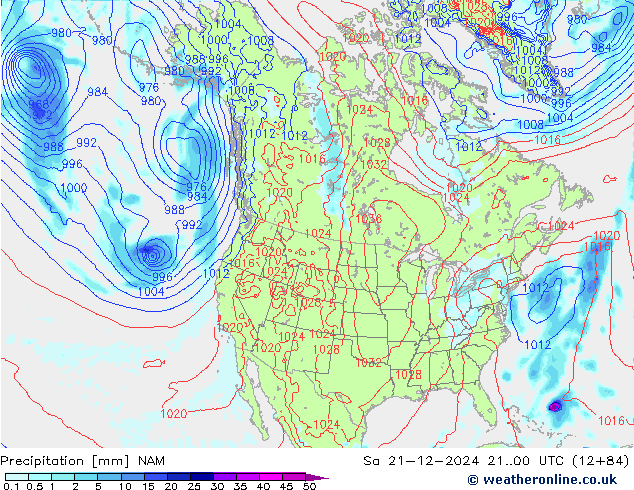
The 6z nam gives us the goods,each run gets better.
-
All models have crept closer to the coast cept the gfs. The nam looks interesting even if it is at the tail of its run.