.jpg.93eb8afe5d1df4d67bc0eeb78d645380.jpg)
.jpg.7cbeb4b469bd18d447fac5868c43a091.jpg)
Yardstickgozinya
-
Posts
1,681 -
Joined
Content Type
Profiles
Blogs
Forums
American Weather
Media Demo
Store
Gallery
Everything posted by Yardstickgozinya
-
.thumb.jpg.6a4895b2a43f87359e4e7d04a6fa0d14.jpg)
Central PA Summer 2026 Discussion/Obs Thread
Yardstickgozinya replied to Voyager's topic in Upstate New York/Pennsylvania
I completely agree, chances are this will be sporadic at best and that's perfectly fine. However, the one thing that all the top dogs have in common is the presence of the EML. It seems to be the main deciding factor between more of the same and a true widespread sig/svr weather when other enhanced indices are present. -
Central PA Summer 2026 Discussion/Obs Thread
Yardstickgozinya replied to Voyager's topic in Upstate New York/Pennsylvania
I'm not familiar with that outbreak. However, it was a major player in the 5/31/85 outbreak for western pennsylvania. An additional component to the magnitude of the thunderstorms on May 31st was the presence of a significant “elevated mixed layer” (EML) , a common supporting ingredient in severe weather across the northeastern U.S. (Banacos and Ekster). EMLs act as a ‘lid’ in the atmosphere, stopping convection from occurring unless the lid can be removed or sufficient lift is present. The strength of the front and the degree of instability lead to the erosion or breaking of the cap and thunderstorms exploded with violent results. This following two figures from Markowski show 1, the presence of the EML in the 7pm May 31st Pittsburgh sounding and 2, the formation and subsequent migration of the EML across the United States. The following hand-analyzed upper air maps (provided by NWS Cleveland) from the morning of the 31st highlight the significant area of dry air (yellow shading) or ‘cap’ coming into play. The forecaster even analyzed a dryline (the bumpy blue line through the central Plains) on the 850mb map, showing the leading edge of the dry air. -
Central PA Summer 2026 Discussion/Obs Thread
Yardstickgozinya replied to Voyager's topic in Upstate New York/Pennsylvania
If you dont believe me, then maybe you'll believe the american meteorological society. https://journals.ametsoc.org/view/journals/wefo/25/4/2010waf2222363_1.xml
-
Central PA Summer 2026 Discussion/Obs Thread
Yardstickgozinya replied to Voyager's topic in Upstate New York/Pennsylvania
Thursday is looking particularly interesting and it's truly worth keeping an eye on. Keyword elevated mixed layer. That's the main dynamic that keeps us safe out here east of the mighty mississipp and why we almost never see the big outbreaks the central and western united states sees. If it truly surges out ahead, this absolutely could be one for the record books. Contrary to popular belief It's not the mountains, the ocean breeze or lack of unmodified gulf air, thst prevents Central and Western type outbreaks from occurring this far east . EML lag is the true culprit. if we have the EML we're capable of achieving Central and Western United States type indices ,including those gargantuan fat capes in excess of 4000jkg that the MA/NE only see every thirty to forty years. -
Central PA Summer 2026 Discussion/Obs Thread
Yardstickgozinya replied to Voyager's topic in Upstate New York/Pennsylvania
It's not unusual for me to step away for work and play, tis the season. When it comes to any kind of digital media less is better, so good for you. The concrete reality is, that there's a million different better and healthier ways you can spend time than being online. It's bad for the body and mind.I don't think thst there was any coincidence to the fact that I spent three weeks laid up with bodily injury early this spring. after leading the post count by a large margin, just a few weeks prior. The older I get, the more I notice a correlation between sedentary behavior and emotional and physical discomfort. That said, you're an integral part of this forum and an OG and it wouldn't be the same without you. -
Central PA Summer 2026 Discussion/Obs Thread
Yardstickgozinya replied to Voyager's topic in Upstate New York/Pennsylvania
Not that anybody probably cares, but I got so far behind in work and life I decided to drop the forum for a while and until I got caught up. -
Central PA Summer 2026 Discussion/Obs Thread
Yardstickgozinya replied to Voyager's topic in Upstate New York/Pennsylvania
There are some questions about tomorrow's setup, the big one, being the possible lack of instability. What started off looking like could be an anomalous storm season for cpa fell off a cliff quick. Instability and weak capping has been about as hard to come by the spring, as any of i've seen. That said, we all know big shifts are taking place right now so let's see what happens. Seems like we're moving in the right direction for increased convection opportunities and most importantly precipitation. -
Central PA Summer 2026 Discussion/Obs Thread
Yardstickgozinya replied to Voyager's topic in Upstate New York/Pennsylvania
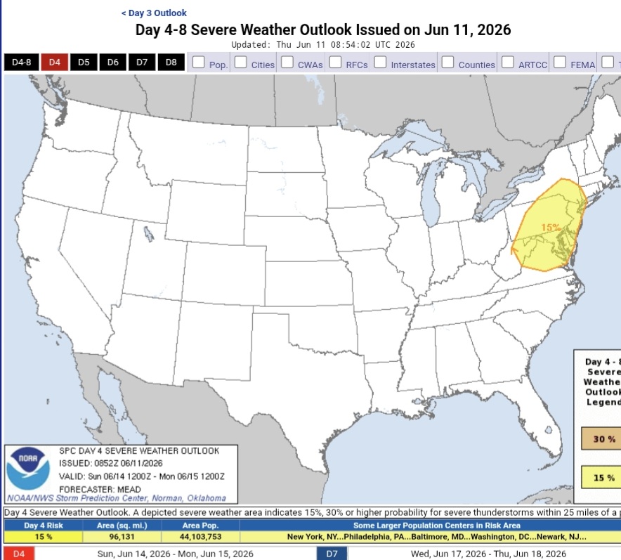
ZCZC SPCSWOD48 ALL ACUS48 KWNS 130753 SPC AC 130753 Day 4-8 Convective Outlook NWS Storm Prediction Center Norman OK 0253 AM CDT Sat Jun 13 2026 Valid 161200Z - 211200Z ...DISCUSSION... ...Days 5-6/Wed-Thu -- Lower MO/Mid-MS Valley to Ohio Valley and Mid-Atlantic... An upper trough is forecast to deepen over the Upper Midwest/Great Lakes on Wednesday. As this occurs, an intensifying 500 mb jet streak will develop across the central Plains and increase to 80-100 kt as it moves into the Mid-MS Valley Wednesday night, and spreads eastward across the Ohio Valley and Northeast on Thursday. At the surface, low pressure will develop over the northern/central Plains late Tuesday night into early Wednesday. As this occurs, increasing southerly low-level flow will quickly transport rich Gulf moisture northward into the Lower MO/Mid-MS Valley by Wednesday afternoon as the surface low moves across IA and a trailing cold front moves eastward in tandem with the low across portions of the central Plains and Mid-MS Valley. Strong to extreme instability is forecast across the strongly sheared warm sector. An all-hazards severe thunderstorm event appears likely. An intense southwesterly low-level jet is expected to develop during the evening. This could support upscale growth into an MCS moving across portions of the Midwest Wednesday night, posing a risk for swaths of damaging winds. This system will spread east on Thursday across parts of the Ohio Valley into the Mid-Atlantic/Northeast. A continued risk for all severe hazards, and possible MCS with damaging winds, will persist as the mid/upper jet streak is forecast to remain quite strong as it overspreads a seasonally moist airmass. While some timing differences of aforementioned features is evident in various NWP guidance, overall medium range consensus and mean calibrated ML/AI guidance suggests a multi-day severe episode is likely as this system overspreads portions of the Midwest to the Mid-Atlantic/Northeast, though the 15 percent risk areas may shift in the coming days as details become better resolved, and higher probabilities are possible in subsequent outlooks. The southern extent of severe potential is more uncertain across parts of the Plains toward the TN Valley as these areas will remain further removed from stronger flow aloft -
Central PA Summer 2026 Discussion/Obs Thread
Yardstickgozinya replied to Voyager's topic in Upstate New York/Pennsylvania
Sunday The 00z models have trended toward a much stronger short-wave trough and associated mid-level jet, which will progress from the Great Lakes and OH Valley into the Northeast. Elsewhere, a short-wave trough is forecast to move from the northern Rockies into the central Plains. At the surface, a cold front attendant to the Northeast short-wave trough will move through that region with the trailing extension of the boundary pushing south through the OH and TN Valleys into the Gulf Coast states. A much stronger low-level jet is now forecast ahead of the cold front across the Northeast, which will aid in greater air mass destabilization than indicated in previous model runs. When coupled with notably stronger vertical shear, the setup appears favorable for organized severe storms across the Mid-Atlantic, potentially into southern New England Sunday afternoon and evening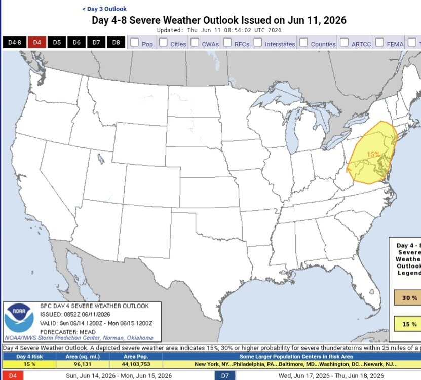
-
Central PA Summer 2026 Discussion/Obs Thread
Yardstickgozinya replied to Voyager's topic in Upstate New York/Pennsylvania
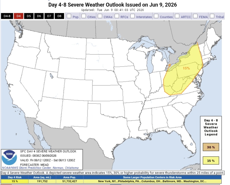
ZCZC SPCSWOD48 ALL ACUS48 KWNS 090838 SPC AC 090838 Day 4-8 Convective Outlook NWS Storm Prediction Center Norman OK 0338 AM CDT Tue Jun 09 2026 Valid 121200Z - 171200Z ...DISCUSSION... ...Day 4/Friday... The last several deterministic model runs have consistently shown the progression of a short-wave trough and associated 50 kt jet streak from the OH Valley into the St. Lawrence Valley, with meaningful height falls as far south as the Mid-Atlantic. At the surface, the northern portion of a cold front initially from southwest Ontario to near the confluence of the MS and OH Rivers and into the southern Plains will progress southeast and eventually merge with a trough stretching from southern New England to the Carolina Piedmont. Ahead of the front, boundary-layer dewpoints in the 60s to low/mid 70s will combine with modestly steep mid-level lapse rates, especially across the lower Great lakes, to yield a moderately unstable air mass by afternoon. Initial storms are anticipated across the lower Great Lakes into upper OH Valley by early afternoon, with activity advancing east toward the Hudson Valley, and southeast into the central Appalachians and Mid-Atlantic through the remainder of the afternoon into evening. The strongest vertical shear is forecast from the lower OH Valley to the lee of the lower Great Lakes, where organized storm modes capable of damaging winds and large hail appear most probable. Elsewhere, a more isolated severe-weather threat may materialize within a low-level upslope regime in eastern NM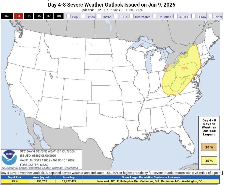
-
Central PA Spring 2026 Discussion/Obs Thread
Yardstickgozinya replied to Voyager's topic in Upstate New York/Pennsylvania
-
Central PA Spring 2026 Discussion/Obs Thread
Yardstickgozinya replied to Voyager's topic in Upstate New York/Pennsylvania
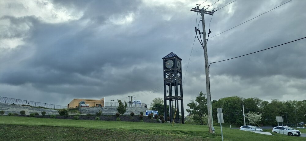
The skys are looking convective out here in mechanicsburg -
Central PA Spring 2026 Discussion/Obs Thread
Yardstickgozinya replied to Voyager's topic in Upstate New York/Pennsylvania
I have a feeling a few local growers won't be recovering. Put this loss on top of the hike in insect disease and pest management overhead over the last few years, it gives these guys a lot to think about. -
Central PA Spring 2026 Discussion/Obs Thread
Yardstickgozinya replied to Voyager's topic in Upstate New York/Pennsylvania
Yes, it is.And it's such a tough time already for everyone. I'm not sure about them specifically, but crop damage is still rolling in as of today. Just found out that strawberries took a huge hit.I thought that they'd be okay. -
Central PA Spring 2026 Discussion/Obs Thread
Yardstickgozinya replied to Voyager's topic in Upstate New York/Pennsylvania
Unfortunately, they are reporting a significant loss of fruit there. Viticulturist reports aren't looking very good either. It's gonna be a rough year for local wine production. -
Central PA Spring 2026 Discussion/Obs Thread
Yardstickgozinya replied to Voyager's topic in Upstate New York/Pennsylvania
The cellular damage from that freeze didn't show right away.It really sticks out like a sore thumb now when you look at plants and bushes the last 2 Three days ago, japanese maples looked fine.Today, pretty much everyone i've come across. looks just like this one.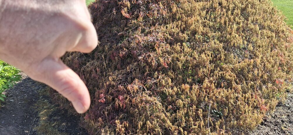
-
Central PA Spring 2026 Discussion/Obs Thread
Yardstickgozinya replied to Voyager's topic in Upstate New York/Pennsylvania
The above was written a few days ago. The main abortions of fruitlits has been occurring for the last three days. -
Central PA Spring 2026 Discussion/Obs Thread
Yardstickgozinya replied to Voyager's topic in Upstate New York/Pennsylvania
https://extension.psu.edu/pennsylvania-tree-fruit-phenology-report-april-21-2026/ Frost Ring Formation Throughout much of the state overnight between April 20-21, temperatures posed a serious risk to fruit crops. Apple, peach, and pear crops may have experienced varying levels of damage depending on developmental stage and site-specific conditions. Apples are at petal fall in Adams County and at full bloom in Center County. Although fertilized flowers and young fruitlets are less sensitive to freezing temperatures than blossoms at full bloom, exposure to critical temperatures may have resulted in tissue injury, leading to embryo damage, fruitlet abortion, or subsequent quality defects. There was also potential for frost ring formation under the forecasted conditions -
Central PA Spring 2026 Discussion/Obs Thread
Yardstickgozinya replied to Voyager's topic in Upstate New York/Pennsylvania
I knew it was going happen before it did. It wasn't just about the freeze.It was also about the stage of fruit development. -
Central PA Spring 2026 Discussion/Obs Thread
Yardstickgozinya replied to Voyager's topic in Upstate New York/Pennsylvania
I apologize if it's already been talked about. I'm haven't been stopping around the forum too much lately. Many fruit farms are reporting 100% loss of fruit as of today from the last freeze. I myself also lost everything. The last freeze did turn out to be locally, one of the most agricultural devastating freezes since i've been a member here. -
Central PA Spring 2026 Discussion/Obs Thread
Yardstickgozinya replied to Voyager's topic in Upstate New York/Pennsylvania
Absolutely, I saw that in the discussion today, pray for clouds and wind. -
Central PA Spring 2026 Discussion/Obs Thread
Yardstickgozinya replied to Voyager's topic in Upstate New York/Pennsylvania
This isn't the usual freeze hype . Tonight's the real deal and a very concerning situation for local fruit farmers. Any amount of time at or below 28°F will be catastrophic to local fruit farming. Cherry and apple fruitlets have already developed. Fruitlets go from alive and well at 29°F to complete cellular damage and abortion at 28°F. -
Central PA Spring 2026 Discussion/Obs Thread
Yardstickgozinya replied to Voyager's topic in Upstate New York/Pennsylvania
.51" -
Central PA Spring 2026 Discussion/Obs Thread
Yardstickgozinya replied to Voyager's topic in Upstate New York/Pennsylvania
-
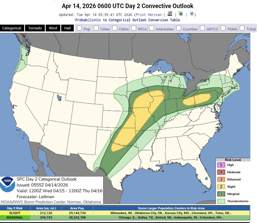
Central PA Spring 2026 Discussion/Obs Thread
Yardstickgozinya replied to Voyager's topic in Upstate New York/Pennsylvania
Wednesday's convective outlook. Slight risk sneaking into north and west central pennsylvania. https://www.spc.noaa.gov/products/outlook/day2otlk.html