.jpg.93eb8afe5d1df4d67bc0eeb78d645380.jpg)
.jpg.7cbeb4b469bd18d447fac5868c43a091.jpg)
Yardstickgozinya
-
Posts
1,681 -
Joined
Content Type
Profiles
Blogs
Forums
American Weather
Media Demo
Store
Gallery
Everything posted by Yardstickgozinya
-
.thumb.jpg.6a4895b2a43f87359e4e7d04a6fa0d14.jpg)
Central PA Summer 2026 Discussion/Obs Thread
Yardstickgozinya replied to Voyager's topic in Upstate New York/Pennsylvania
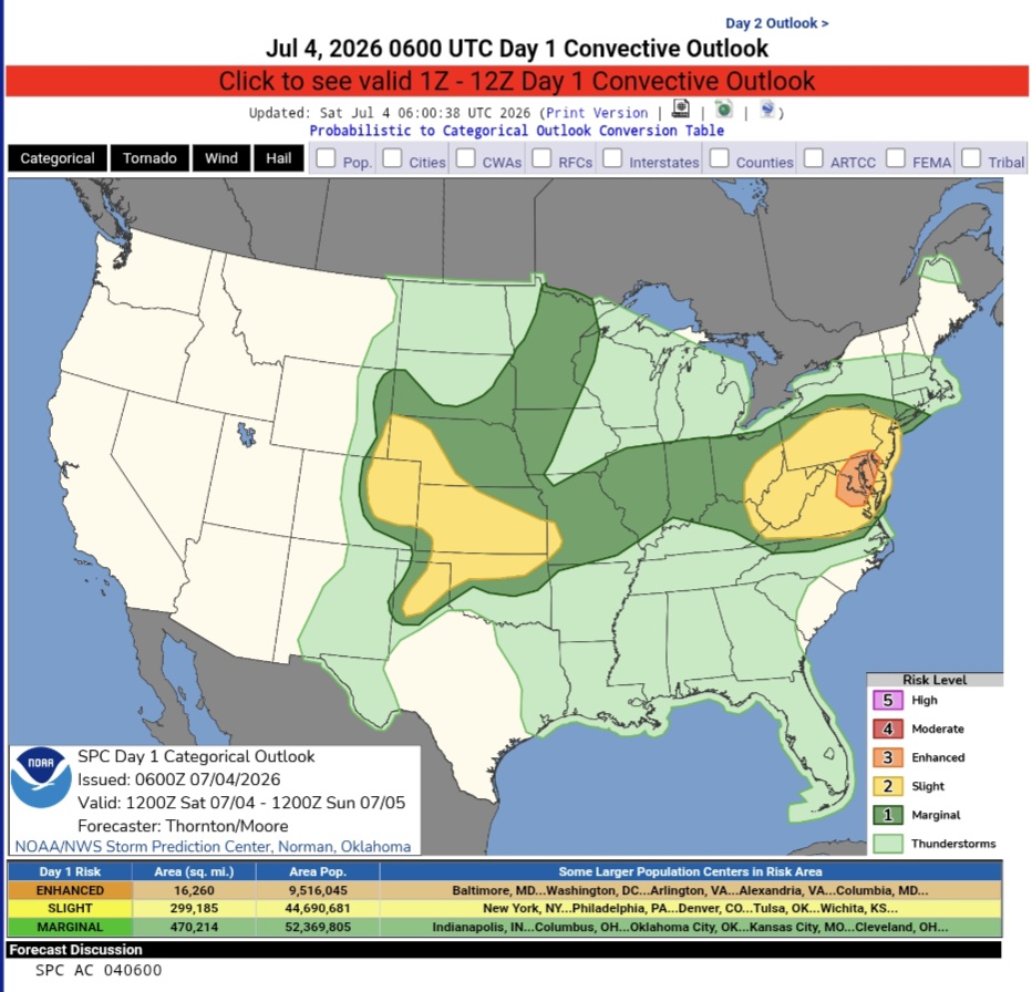
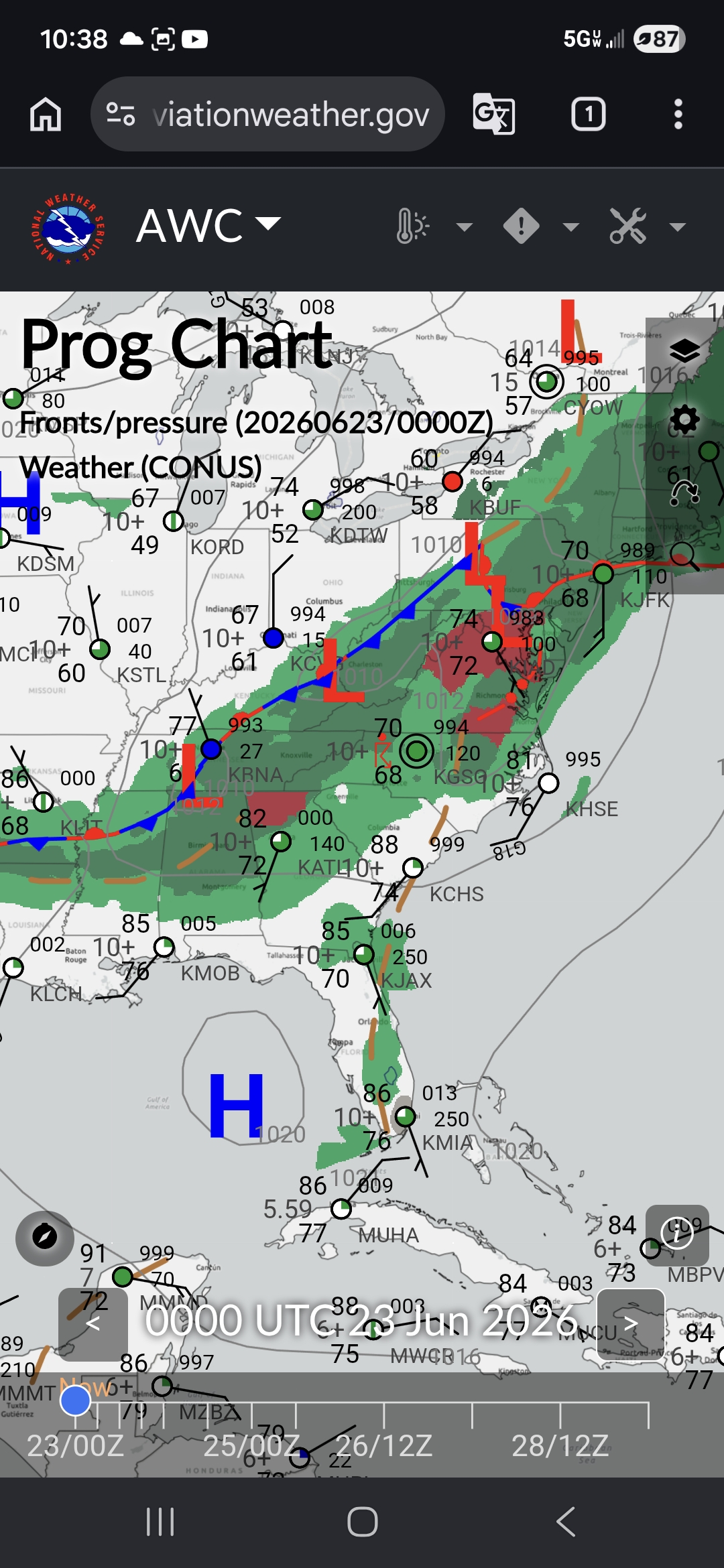
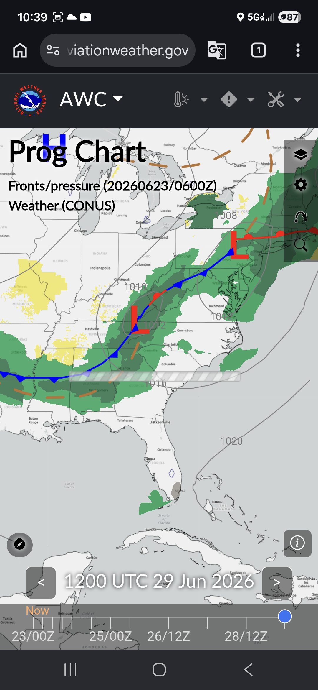
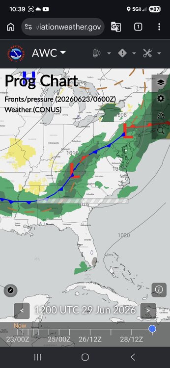
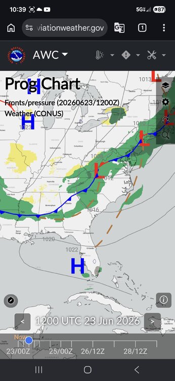
Happy Independence to those who acknowledge the United States is the greatest country in the world ,and all those who serve and have served America. Stay safe out there, especially, you extreme southeastern folk. Day 1 Convective Outlook NWS Storm Prediction Center Norman OK 0100 AM CDT Sat Jul 04 2026 Valid 041200Z - 051200Z ...THERE IS AN ENHANCED RISK OF SEVERE THUNDERSTORMS PORTIONS OF THE MID-ATLANTIC... ...THERE IS A SLIGHT RISK OF SEVERE THUNDERSTORMS ACROSS PORTIONS OF THE CENTRAL/SOUTHERN PLAINS... ...SUMMARY... Clusters of storms will move across parts of the Allegheny Plateau into Mid Atlantic, with potential for widespread damaging wind. Additional thunderstorms are expected across the Great Plains Saturday afternoon and evening, posing a risk for damaging wind gusts. Large hail is also possible across the Great Plains. ...Synopsis... Height rises will continue across the western US, with more zonal flow across the central US and upper-level troughing across the Northeast and Quebec/Ontario. A modest belt of westerly flow around 30-40 kts will move through the trough in the Northeast/Mid-Atlantic. A compact shortwave trough with enhanced westerly flow will move through the flow across the Central Plains. ...Eastern Ohio Valley into the Mid-Atlantic... Activity will likely be ongoing across some portion of northern PA into northern NJ this morning. This will likely contribute to lingering cloud cover and more muted daytime heating/recovery with northern extent. South of the morning precipitation, strong daytime heating and warming is expected, with temperatures climbing into the 90s to 100s F. A plume of steep mid-level lapse rates is already in place across the region from WV into VA/MD/NJ. With daytime heating, low-level lapse rates are expected to increase with moderate to strong instability by the afternoon. Deep layer shear profiles will be generally weak, with better shear to the north. Nonetheless, several thunderstorm clusters are expected to develop across the Blue Ridge Mountains/Shenandoah Valley moving north and eastward though the afternoon. These will have the potential to produce widespread damaging wind, especially if clusters can grow upscale and develop strong cold pools. https://www.spc.noaa.gov/products/outlook/day1otlk.html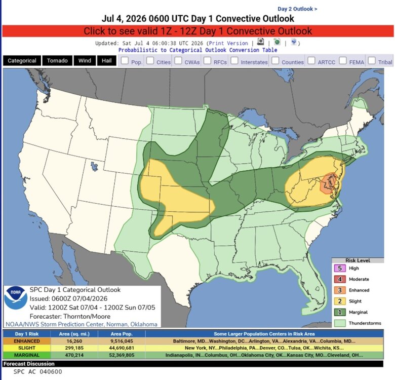
-
Central PA Summer 2026 Discussion/Obs Thread
Yardstickgozinya replied to Voyager's topic in Upstate New York/Pennsylvania
Never should have happened in the first place.Somebody should have spoke up. -
Central PA Summer 2026 Discussion/Obs Thread
Yardstickgozinya replied to Voyager's topic in Upstate New York/Pennsylvania
Yes I agree too thank you. -
Central PA Summer 2026 Discussion/Obs Thread
Yardstickgozinya replied to Voyager's topic in Upstate New York/Pennsylvania
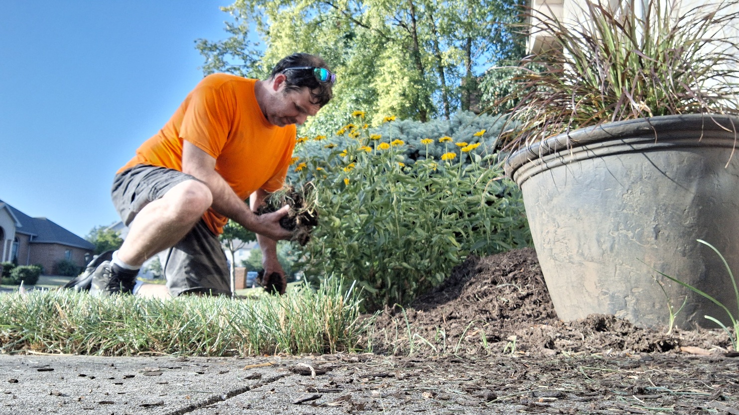
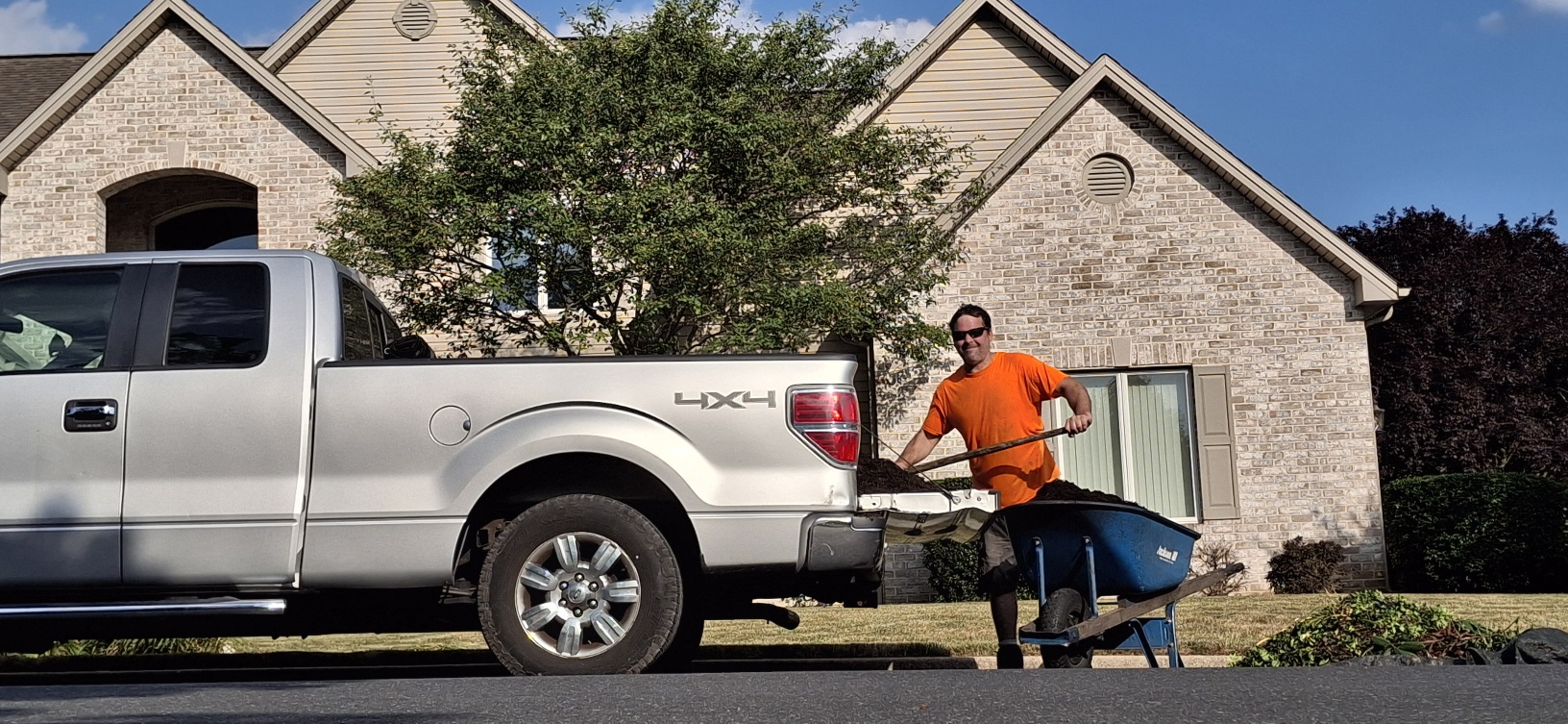
This snowflake just wrapped up day three of mulching in 100+ degree heat. Now about to head home, throw my catfish gear and bait in my truck and heading on down to lake Aldred to catch me some monster flatties on this old school true summer night. Living the snowflake lifestyle this weekend and loving it.
-
Central PA Summer 2026 Discussion/Obs Thread
Yardstickgozinya replied to Voyager's topic in Upstate New York/Pennsylvania
Continuous LEMPs being picked up on my AM frequencies. The flash rate tonight should be intense if we can hold on to some of this stuff until the sun sets.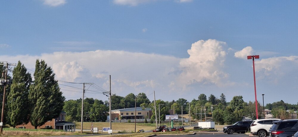
-
Central PA Summer 2026 Discussion/Obs Thread
Yardstickgozinya replied to Voyager's topic in Upstate New York/Pennsylvania
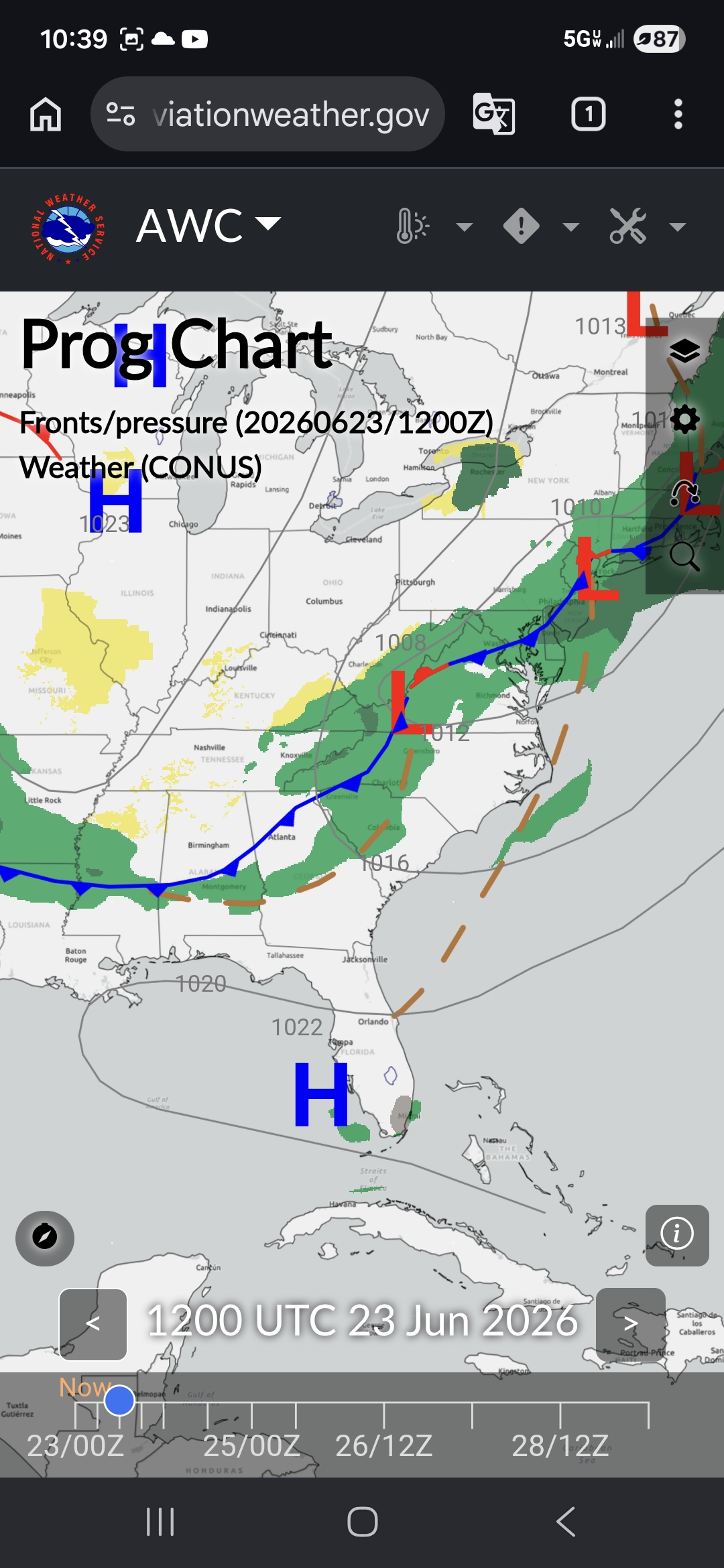
Mid level surface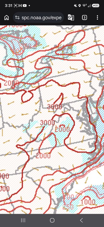

-
Central PA Summer 2026 Discussion/Obs Thread
Yardstickgozinya replied to Voyager's topic in Upstate New York/Pennsylvania
You're only going to pretend to believe people who support your virtues and that's where it ends for a dirtbags like you. The fact that he said that you need 5000" to make a big difference completely discredits, anything that he would ever try to tell me. Maybe someday you and others ideological low lifes on the forum will learn that its become obvious to decent folk without their heads stuck up their ideological a**s that you're just speaking through emotion, ideology and virtue, It's tremendously f****** annoying to people that aren't f****** d*****bags. Now, do me a favor buddy and go f*** yourself and your mother along with all the other people that constantly think they need to spout of the same stupid f****** talking points every time the temperature spikes. Plenty of dbags over in the MA that will gladly applaud you for being a the quintessential definition of a dbag. -
Central PA Summer 2026 Discussion/Obs Thread
Yardstickgozinya replied to Voyager's topic in Upstate New York/Pennsylvania
Stay in school kids get good grades.
-
Central PA Summer 2026 Discussion/Obs Thread
Yardstickgozinya replied to Voyager's topic in Upstate New York/Pennsylvania
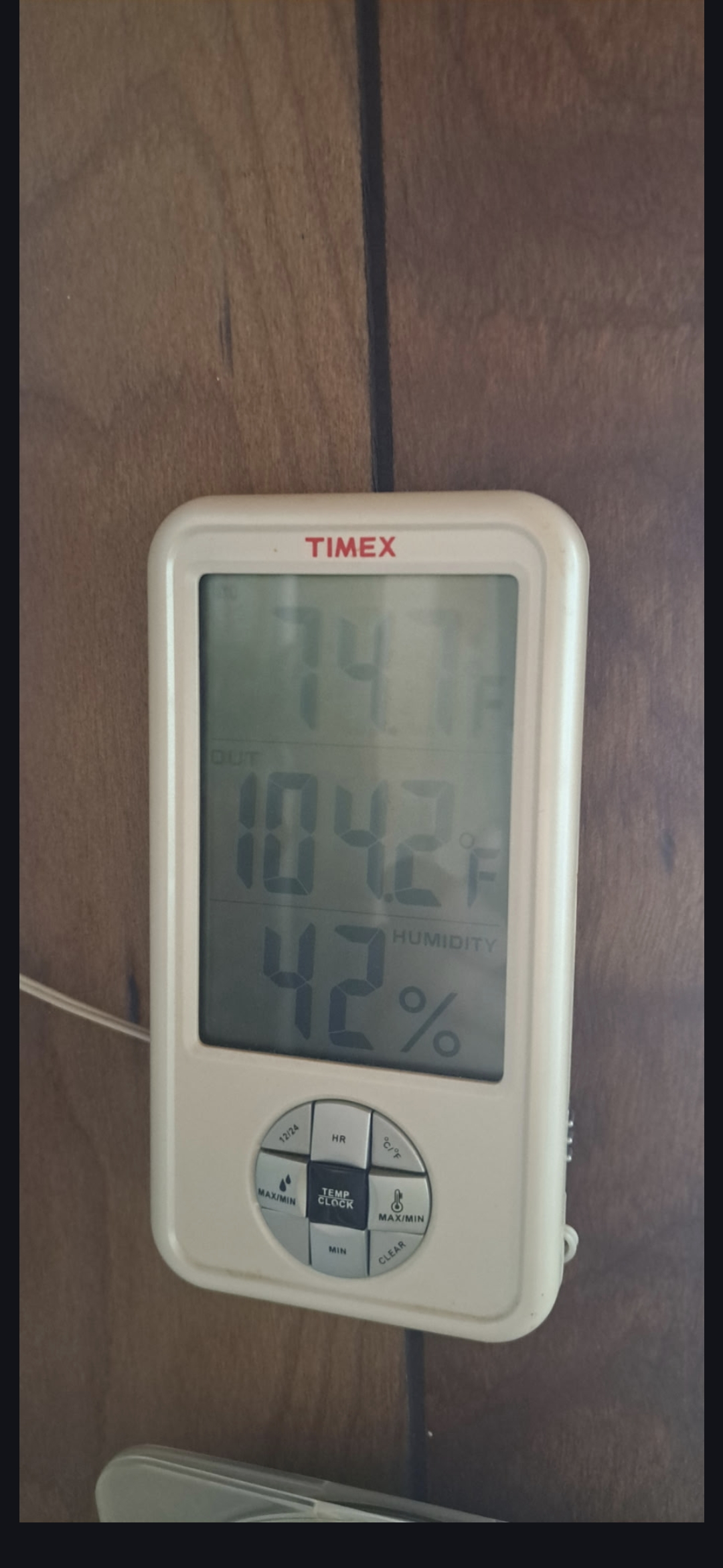
From the porch, i'm laying mulch at today. Not sure how accurate it is.But it's definitely worse than yesterday.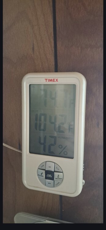
-
Central PA Summer 2026 Discussion/Obs Thread
Yardstickgozinya replied to Voyager's topic in Upstate New York/Pennsylvania
I just had to make way for the local porta john for a heat related blowout, if you know what I mean. It must have been a hundred and forty degrees inside that f****** thing. That turned my day real s***** quick no pun intended. -
Central PA Summer 2026 Discussion/Obs Thread
Yardstickgozinya replied to Voyager's topic in Upstate New York/Pennsylvania
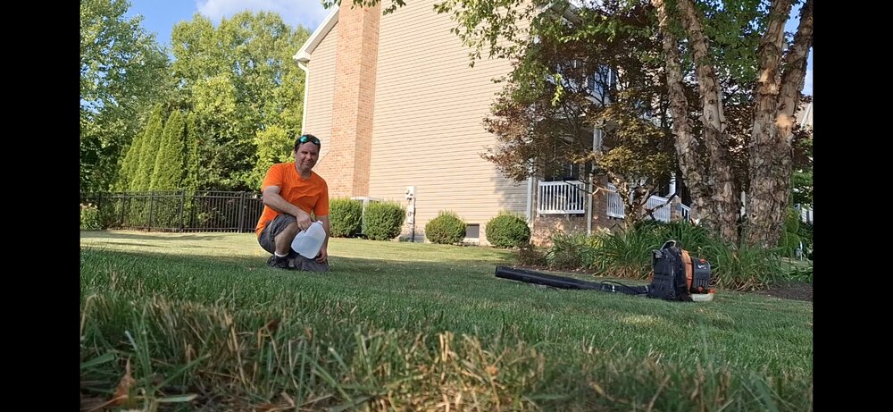
I think it hit exactly 100°F here in Mechanicsburg, but i'm not sure. I'm getting through it alright. I'm drenched in sweat, but i've been keeping up on my electrolytes, and using my backpack blower to fan myself off at times. Looking forward to jumping in the pool for the first time this summer when I get home around nine o'clock.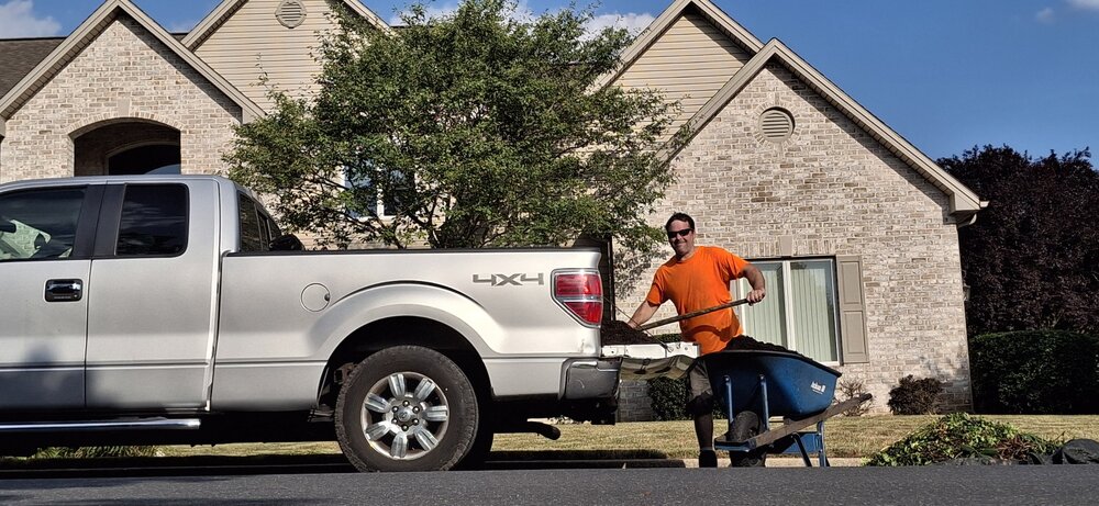
-
Central PA Summer 2026 Discussion/Obs Thread
Yardstickgozinya replied to Voyager's topic in Upstate New York/Pennsylvania
Yes, indeed. The thought for my post post was inspired by yours. -
Central PA Summer 2026 Discussion/Obs Thread
Yardstickgozinya replied to Voyager's topic in Upstate New York/Pennsylvania
If I remember correctly, we do have someone here that was also at Griffiths air force base in Rome, New York, July 22 to 25 1999. That's as hot is i've ever been and probably ever will be. At this age my body would not be able to tolerate what we had to endure at that festival. 110°F+ on that endless tarmac from hell with almost no shade or working bathrooms for 4 days and hot nights. Looking back at it as an older adult, all the organizers for that festival should have been imprisoned. Water and food was nearly impossible to find, and the price for a bottle of water was over $13.00 and $15.00+ for a hot dog or a slice of pizza by day 3. It was a four day event during a heat wave that no one was allowed to bring food or drinks through .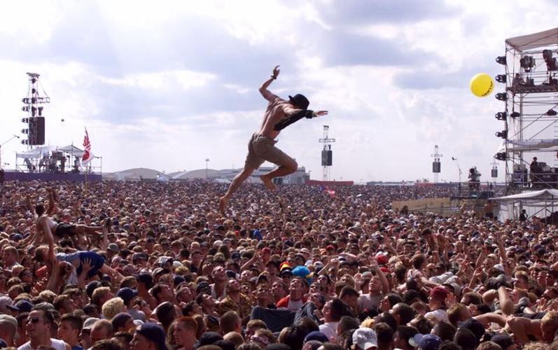
-
Central PA Summer 2026 Discussion/Obs Thread
Yardstickgozinya replied to Voyager's topic in Upstate New York/Pennsylvania
I was just thinking to myself about the corn crop. The fields aren't going to look the same after next week. I'm going to go out on a limband say that Pennsylvania agriculture is looking down the barrel of a season, that could end up more disastrous. than 1930 or 1999 by a long shot. -
Central PA Summer 2026 Discussion/Obs Thread
Yardstickgozinya replied to Voyager's topic in Upstate New York/Pennsylvania
Generally we dry out after the main vegetative cycle is over. Drying out like this while things were in their main vegetative stage isn't something we see a whole lot, and it's going to be a lot worse then if it were later. It also may not be as bad for many of you as what i'm witnessing here, i've been missed by almost everything over the last a few weeks. -
Central PA Summer 2026 Discussion/Obs Thread
Yardstickgozinya replied to Voyager's topic in Upstate New York/Pennsylvania
I just took a walk i've been trying to avoid to assess edaphic stress on the lower layers.. This is another dire situation for our farmers, especially rubus field's without irrigation. BIosemiotic abortion has begun in all rubus and that won't be reversed even with rain at this point. -
Central PA Summer 2026 Discussion/Obs Thread
Yardstickgozinya replied to Voyager's topic in Upstate New York/Pennsylvania
-
Central PA Summer 2026 Discussion/Obs Thread
Yardstickgozinya replied to Voyager's topic in Upstate New York/Pennsylvania
Hopefully not your tomatoes. The radar is actually starting to fill in and develop some taller echoes at the moment. Hopefully we can get some of those into our area today. -
Central PA Summer 2026 Discussion/Obs Thread
Yardstickgozinya replied to Voyager's topic in Upstate New York/Pennsylvania
Well, at this point it's getting a little out of hand. We really need to get some rain, leading up to this, or it's going to be problematic for plants, animals and humans alike. The herbaceous and ground layer is already exhibiting some edaphic stress in my area. , especially along road and highway verges. -
Central PA Summer 2026 Discussion/Obs Thread
Yardstickgozinya replied to Voyager's topic in Upstate New York/Pennsylvania
This is the first time that i've been able to access the forum in over 24 hours. I'm not even sure if I'll be able to post this without another error. Has anyone reported the bad gateway to admin ? -
Central PA Summer 2026 Discussion/Obs Thread
Yardstickgozinya replied to Voyager's topic in Upstate New York/Pennsylvania
My kind of weather. Let's do this -
Central PA Summer 2026 Discussion/Obs Thread
Yardstickgozinya replied to Voyager's topic in Upstate New York/Pennsylvania
I mean, the NWS very well could be smoking crack. I'm going to keep my hope alive because we do really need the rain . Maybe us local guys need to get together for a powwow and rain dance. I'll bring the brownies.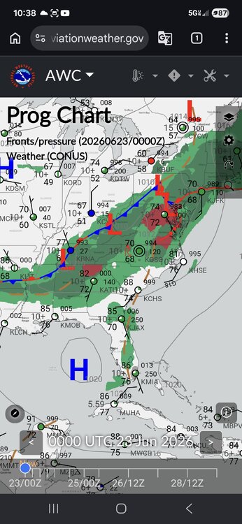
-
Central PA Summer 2026 Discussion/Obs Thread
Yardstickgozinya replied to Voyager's topic in Upstate New York/Pennsylvania
We had more than enough cape around today to spark off storms and still do. Looks like an inversion problem to me. -
Central PA Summer 2026 Discussion/Obs Thread
Yardstickgozinya replied to Voyager's topic in Upstate New York/Pennsylvania
Just to be clear, i'm speaking of tornado genesis, not of severe weather itself.That possibility is very much still there. -
Central PA Summer 2026 Discussion/Obs Thread
Yardstickgozinya replied to Voyager's topic in Upstate New York/Pennsylvania
There's still time for things to happen. The overlap of surface vorticity and cape that they spoke of yesterday looks to be in jeopardy, to me.