.jpg.93eb8afe5d1df4d67bc0eeb78d645380.jpg)
.jpg.7cbeb4b469bd18d447fac5868c43a091.jpg)
Yardstickgozinya
-
Posts
618 -
Joined
About Yardstickgozinya

- Birthday 02/18/1979
Recent Profile Visitors


-
.thumb.jpg.6a4895b2a43f87359e4e7d04a6fa0d14.jpg)
Central PA Spring 2025
Yardstickgozinya replied to canderson's topic in Upstate New York/Pennsylvania
If you're referring to my post I just forgot to address it. Its just a scwobble among two guy know one likes. Apparently we are both somewhat mentaly handicapped . Probably nothing the nerotypical want to get involved with. -
Central PA Spring 2025
Yardstickgozinya replied to canderson's topic in Upstate New York/Pennsylvania
No worries. I won't be reading or responding to the tool bag an further. -
Central PA Spring 2025
Yardstickgozinya replied to canderson's topic in Upstate New York/Pennsylvania
Lol , What in God's geen earth makes you think I want ,or think it's going to fucking snow in the first place? I posted it because you're literally delusional and possibly the most annoying person to ever post here. It's pretty fucking obvious from my posts and others that most of us have moved on and have been in gardening and severe weather mode for over a month I personally haven't posted about winter in over 5 weeks . I have told you post after post that I agree with you and that I too don't buy into winter storm forcast either, but here you are again lectureing Flatheadsicknes about the insufficiency of the modles. The fact that you think I'm a modle guy just proves how lost you are. There's only one guy in this thread that's still on the snow train and that's his God given right. If it's bothering you that much than I do advise you change, or seek help all jokes aside. -
Central PA Spring 2025
Yardstickgozinya replied to canderson's topic in Upstate New York/Pennsylvania
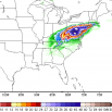
Discussion Day 4-8 Convective Outlook CORR 1 NWS Storm Prediction Center Norman OK 0409 AM CDT Fri Mar 28 2025 Valid 311200Z - 051200Z CORRECTED GRAPHIC ...DISCUSSION... Widespread storms and at least some attendant severe risk will be ongoing at the start of the Day 4 period (Monday March 31) -- with the band of convection likely extending along the west slopes of the Appalachians initially. Diurnal destabilization along and east of the mountains remains a question, particularly with northward extent into the Northeast, and thus the northern periphery of the risk area remains in question -- in what will likely be a very low CAPE/high shear environment -- suggestive of damaging gusts being the primary concern over northern portions of the area. Farther south, greater CAPE is expected, particularly from the Carolinas into the central Gulf Coast states. Here, an all-hazards risk is forecast to continue from the Day 3 period into Day 4. Storms/severe risk will shift eastward with time, crossing the East Coast states through the afternoon and evening, before clearing the coast overnight.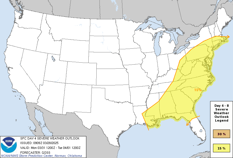
-
Central PA Spring 2025
Yardstickgozinya replied to canderson's topic in Upstate New York/Pennsylvania

-
Central PA Spring 2025
Yardstickgozinya replied to canderson's topic in Upstate New York/Pennsylvania
https://www.spc.noaa.gov/products/outlook/day3otlk.html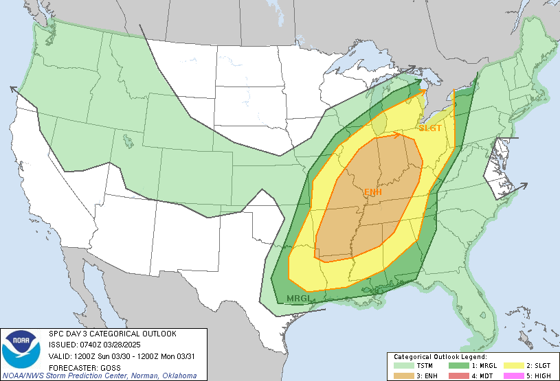
-
Central PA Spring 2025
Yardstickgozinya replied to canderson's topic in Upstate New York/Pennsylvania
So much for keeping it well south. To no surprise 5% probs have been creepin north for this system every few updates over the last few days . There is still a lot of uncertainty to be worked out in coming days. Day 5/Monday, models begin to differ more substantially with respect to surface frontal location -- particularly with northern extent. The GFS depicts the front as extending from New England southwestward to the Texas Coast Monday morning, while the ECMWF places it from Lower Michigan to coastal Texas. By late afternoon,the GFS shows the front reaching the New England coastal area and Mid-Atlantic region, focusing the primary severe threat from the Mid-Atlantic area southwestward. Meanwhile, some risk could extend as far north as the Lower Great Lakes region/central Appalachians per the ECMWF's deterministic forecast. At this time, will keep the Day 5 risk area focused from the Mid-Atlantic region to the lower Mississippi Valley, though adjustments/refinements to the area over the next several days will likely be required.
-
Central PA Spring 2025
Yardstickgozinya replied to canderson's topic in Upstate New York/Pennsylvania
Thers a high probability of a supernova this year and tonight is one of three dates astronomers have targeted. Don't get to excited though. There's not going to be much to see. Hold onto your hats! Is the 'blaze star' T Corona Borealis about to go boom? https://www.space.com/the-universe/stars/hold-onto-your-hats-is-the-blaze-star-t-corona-borealis-about-to-go-boom -
Central PA Spring 2025
Yardstickgozinya replied to canderson's topic in Upstate New York/Pennsylvania
Mr. Poopy paints might want to look under his bun. -
Central PA Spring 2025
Yardstickgozinya replied to canderson's topic in Upstate New York/Pennsylvania
As soon as I walked outside this morning, I caught the smell of something very familiar but, unfortunately, always elusive. I'm ready for spring, but if old Blizz would end up getting to hand out a few frozen shit burgers, I'm OK with that, too. -
Central PA Spring 2025
Yardstickgozinya replied to canderson's topic in Upstate New York/Pennsylvania
.LONG TERM /FRIDAY THROUGH MONDAY/... All medium range guidance indicates the upper trough will be replaced by a building ridge along the East Coast late this week, supporting a trend toward warmer weather late week into next weekend. However, there is plenty of uncertainty regarding how far the dying cold front gets. Some guidance indicates this boundary limps into Northern PA Friday, then lifts north of the border for the weekend. In this scenario, mostly sunny skies and 850mb temps of near 10C south of the front could support widespread highs in the 70s. Other guidance indicates the front stalls out south of PA next weekend, resulting in a much cooler and potentially rainy scenario, with an easterly flow off of the Atlantic and potential overrunning ahead of approaching low pressure over the Midwest. The current weekend forecast reflects a middle ground compromise between these solutions in regards to temps and POPs. There is broad model consensus that an upstream surface low will track over or just north of PA Monday, supporting a good chance or rain or rain showers -
Central PA Spring 2025
Yardstickgozinya replied to canderson's topic in Upstate New York/Pennsylvania
The spc dropped all 5% probabilities they previously had on Saturday for the west sout central but still have a large area highlighted for sunday. At this point, the spc keeps any severe well south of us on Monday as an SLP potentially passes just north or over Pa. mentioned in Noaa's latest forcast discussion..gif.a237f62cf48f0b5e5362540c25c09ab7.gif)
-
Central PA Spring 2025
Yardstickgozinya replied to canderson's topic in Upstate New York/Pennsylvania
Exactly my point. You're counting up a loss/win for a forecast that never existed outside of social media. I don't buy into most of this winter stuff either, but I at least have some grasp on how this all works. Can you tell me who how and with what that 8-14 day forcast you posted was created? I thought you didn't buy into any forecast. You're a very complicated and complex individual. -
Central PA Spring 2025
Yardstickgozinya replied to canderson's topic in Upstate New York/Pennsylvania
.gif.c212ab56ed1449c5ab1e105b83b4ae54.gif)
-
Central PA Spring 2025
Yardstickgozinya replied to canderson's topic in Upstate New York/Pennsylvania
I didn't realize there was a projected winter storm in the forcast. No mention of this on any forcast I can find. What agency did you here this from ?