.jpg.93eb8afe5d1df4d67bc0eeb78d645380.jpg)
.jpg.7cbeb4b469bd18d447fac5868c43a091.jpg)
Yardstickgozinya
-
Posts
658 -
Joined
About Yardstickgozinya

- Birthday 02/18/1979
Recent Profile Visitors


-
.thumb.jpg.6a4895b2a43f87359e4e7d04a6fa0d14.jpg)
Central PA Spring 2025
Yardstickgozinya replied to canderson's topic in Upstate New York/Pennsylvania
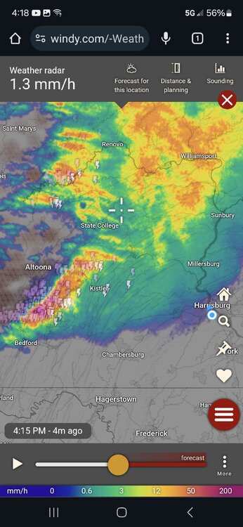
We have some convection in the area. I believe the nws did say the best instability would be overnight. -
Central PA Spring 2025
Yardstickgozinya replied to canderson's topic in Upstate New York/Pennsylvania
Upgrade for the south central tomorrow. https://www.spc.noaa.gov/products/outlook/day2otlk.html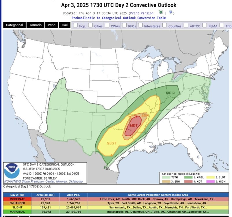
-
Central PA Spring 2025
Yardstickgozinya replied to canderson's topic in Upstate New York/Pennsylvania
I got my little nub shaved off today.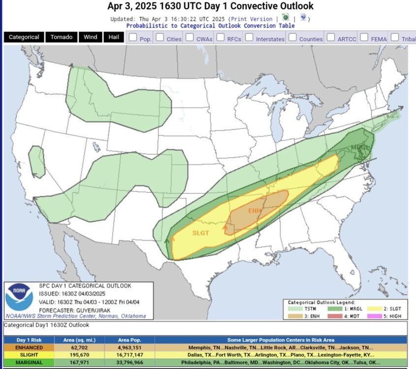
-
Central PA Spring 2025
Yardstickgozinya replied to canderson's topic in Upstate New York/Pennsylvania
It looks like we have some good soaking rains inbound this morning with some possible embedded thunder, but it sounds like our best shot of storms is later tonight from what develops downstream today along the stalled front. -
Central PA Spring 2025
Yardstickgozinya replied to canderson's topic in Upstate New York/Pennsylvania
Today's nws Forecast discussion . Good discussion on our opportunities for rainfall through the weekend. https://forecast.weather.gov/product.php?site=CTP&issuedby=CTP&product=AFD&format=CI&version=1&glossary=1&highlight=off -
Central PA Spring 2025
Yardstickgozinya replied to canderson's topic in Upstate New York/Pennsylvania
Some of us have a little nub, some of us don't. I'm happy with it. https://www.spc.noaa.gov/products/outlook/day1otlk.html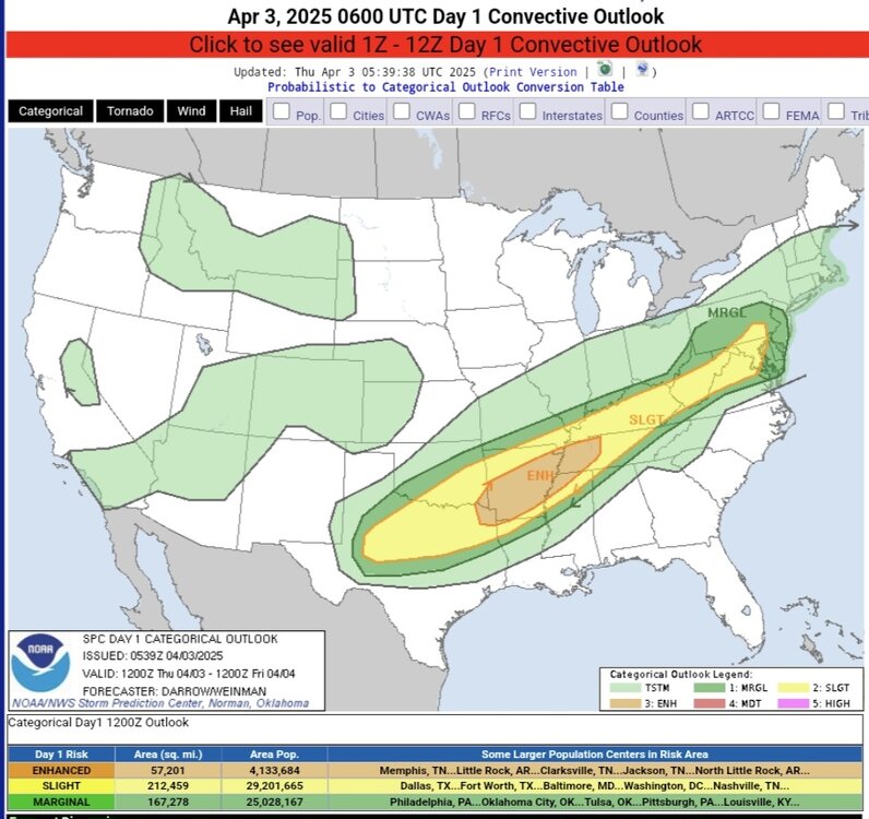
-
Central PA Spring 2025
Yardstickgozinya replied to canderson's topic in Upstate New York/Pennsylvania


-
Central PA Spring 2025
Yardstickgozinya replied to canderson's topic in Upstate New York/Pennsylvania
If your tulips die it wasn't one night of freezing temps that did it. They should be fine. Canderson is 100 on that. -
Central PA Spring 2025
Yardstickgozinya replied to canderson's topic in Upstate New York/Pennsylvania
I had to make a run for the truck. There is not alot of rain here either but the strokes are right on top of me. -
Central PA Spring 2025
Yardstickgozinya replied to canderson's topic in Upstate New York/Pennsylvania
I just heard some powerful ground strokes to my wnw -
Central PA Spring 2025
Yardstickgozinya replied to canderson's topic in Upstate New York/Pennsylvania
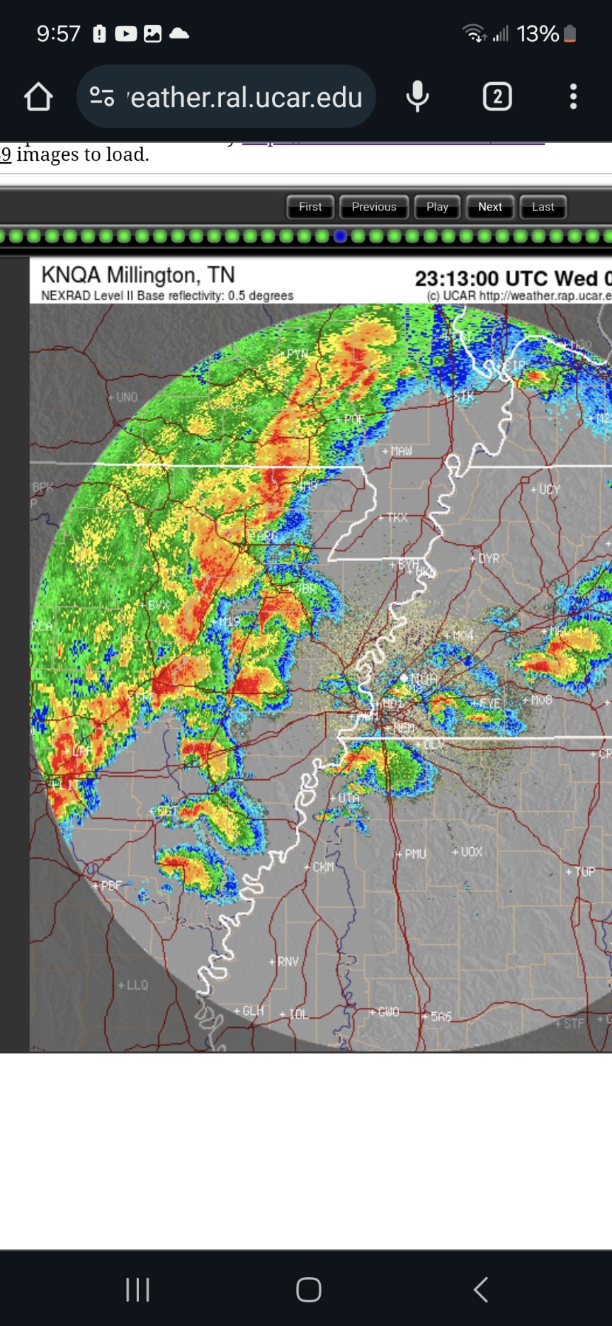
Thunderstorms have started to initiate in the high risk area. I also here thunder, I'm working in Camphill . -
Central PA Spring 2025
Yardstickgozinya replied to canderson's topic in Upstate New York/Pennsylvania
-
Central PA Spring 2025
Yardstickgozinya replied to canderson's topic in Upstate New York/Pennsylvania
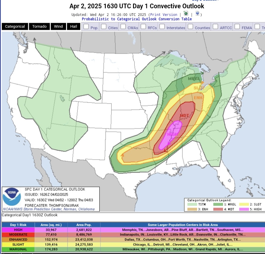
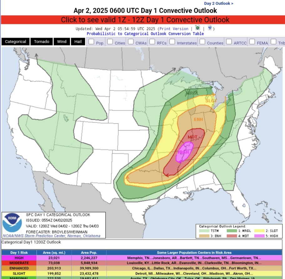
Unfortunately the high risk coverage has expanded since this morning https://www.spc.noaa.gov/products/outlook/day1otlk.html
-
Central PA Spring 2025
Yardstickgozinya replied to canderson's topic in Upstate New York/Pennsylvania
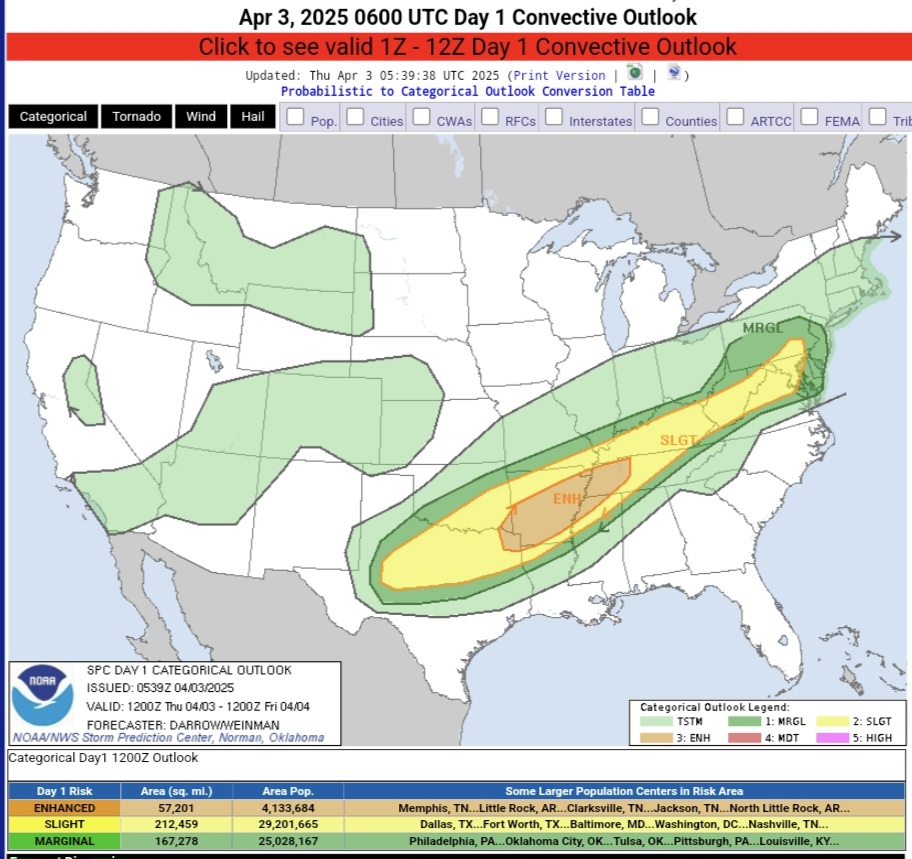
The slight risk has been extended to include a good portion of sw and cpa on Thursday. https://www.spc.noaa.gov/products/outlook/day2otlk.html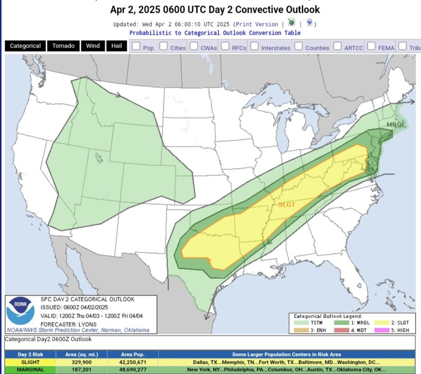
-
Central PA Spring 2025
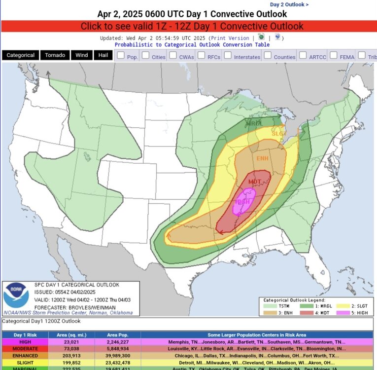
Yardstickgozinya replied to canderson's topic in Upstate New York/Pennsylvania
2nd high risk of the season today. Hopefully its a bust. https://www.spc.noaa.gov/products/outlook/day1otlk.html