

matt9697
-
Posts
274 -
Joined
-
Last visited
Content Type
Profiles
Blogs
Forums
American Weather
Media Demo
Store
Gallery
Everything posted by matt9697
-
Yea, same thing here in Nashville; local TV met just said that they would likely issue a product over night, too bad I guess if you needed to plan ahead or anything lol
-
Nashville will probably do the same then
-
So, wonder what they will put you under as far as advisory? Wondering the same for Nashville....
-
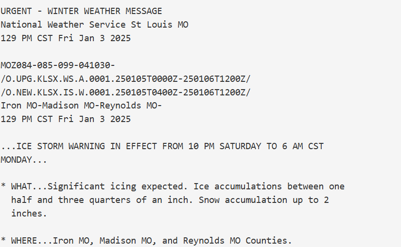
At least no one is under ice storm warnings; I feel for these guys in southern Missouri, .75 of ice is bad
-
That ice is getting too close to me north of Nashville - dont think it matters much if we warm eventually if we get slammed with almost a half inch of ice, the damage will be done by that time!
-
Interesting video; I feel the same way as he does, would not really trust the american modeling, as we have discussed, tends to lose storms. The TN Valley will be in a unique situation by that time in that we will have been cold preceding the storm we wont have the usual saving grace of things melting as it falls. He did mention a mid-week system for this next week, but I had not heard much about that one. We may be in a pattern where threats are not "seen" on modeling until 72 hours out. Now local TV mets are saying severe weather Sunday afternoon after a morning of ice, not sure I have ever seen that before but sure is more interesting this year than last!
-
I like our chances this Winter as a region. I mean, if one considers how different this year is versus last and likely how different it will be from this time next year, one realizes how special it is to just be tracking opportunities!
-
Yea, I would be surprised if people in the forum area didnt score at least once with this pattern, couldnt ask for any better one honestly!
-
The 12Z has placement back north of TN line largely

-
That is a quarter inch in my area, doesnt really go out far enough to really see anything past couple hours early Sunday am
-
Yea, that does give the finger to East TN peeps but looks good for my neck of the woods, however, will almost assuredly change just as all of the historic cold has done!
-
Yep, which helps that gulf low produce a snow storm for mid Georgia and South Carolina lol
-
This is above my paygrade, what does that mean for our weather in TN?
-
That is truth indeed! Have seen it go the opposite direction on them no matter how they call it too many times to count. Weather is difficult but then when you add in the variables we are talking about, it becomes even more difficult!
-
NWS in Nashville is, in my opinion, notoriously stubborn to include any mention of snow in their forecasts, they tend to wait almost to the point that it is actually snowing before they include it in a forecast. Perhaps by tomorrow afternoon models will be putting out a the same solution?
-
Yes, however, looks to me like that second system moved north a bit from the previous run. Places north of here can have the ice!
-
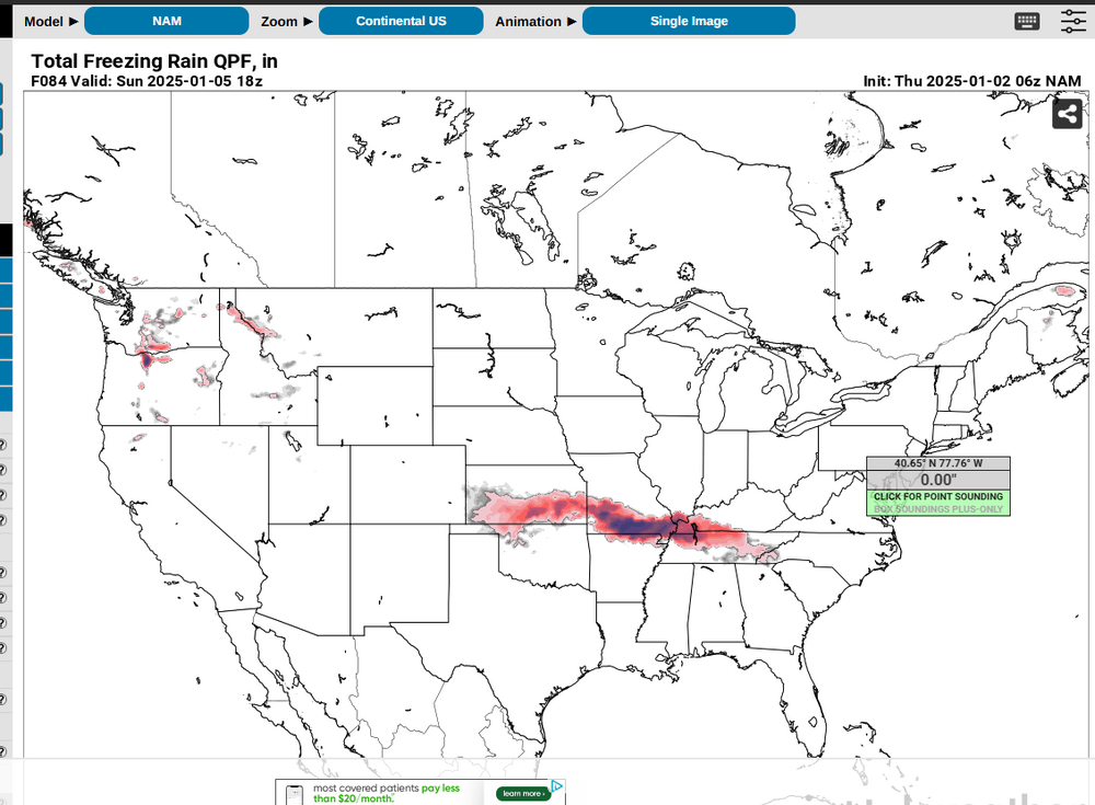
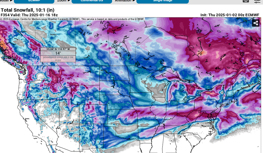
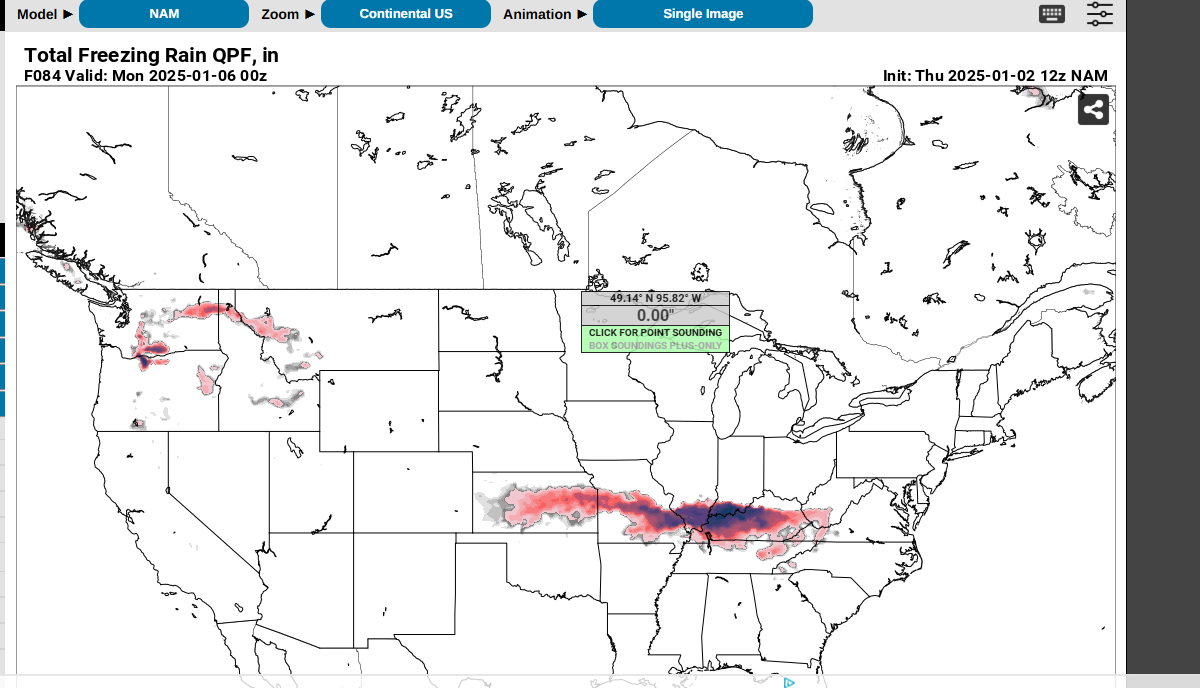
The GFS is still moving around. Look at the last 24 hour of output. The cold seemed stable; however, the latest run brings the coldest air in at the end of the run instead of around the 10th
.thumb.png.5bae5ecb6fbee367ba34fa14189c4598.png)
.thumb.png.445df1d1414cdad1f71af1808d817986.png)
.thumb.png.19375db94bf69def7ab69ea812675890.png)
.thumb.png.105b5dee585eff182d5b8ccaa6234972.png)
.thumb.png.8bbebc1786ffd74cdad9ae950ceb64ca.png)
-
Yea, that is essentially a glacier, no time to modify
-
That will be hard to take if people dont have power because of ice
-
Thats a anafront if I have seen one
-
Yes, I have seen this type of setup cause bad icing just a few miles north of me, though you were likely speaking of TN/KY line in East TN
-
Now it is storming again here; first time I can ever recall where it has stormed three consecutive days in December. Not sure if that means anything or not but it is odd.
-
At this range, no model is going to be correct, especially the GFS, I would expect wide swings in solutions for the next week and change really
-
https://www.tennessean.com/story/news/local/2022/12/23/why-tennessee-valley-authority-ordered-rolling-blackouts-in-nashville/69754538007/
-
Yeah, I know a couple of years ago, TVA had to do rolling blackouts here around Nashville because demand was through the roof, I can't help but think this could cause a similar setup.


.png.0e1b332c08880e44e5e596f34e2b2845.png)
.png.9c830c397c1fd912388e158d1c10732a.png)
.png.73a0665b3059853ec358325c570b3a83.png)
.png.48ae9adf87b758c1295b1fd1b736482f.png)
.png.2a4fc4dcef3475a99f7451d3b1f5c63d.png)
