matt9697
-
Posts
274 -
Joined
-
Last visited
Content Type
Profiles
Blogs
Forums
American Weather
Media Demo
Store
Gallery
Everything posted by matt9697
-
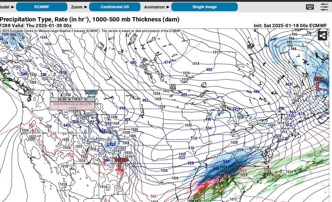
 They are coming down but the flake size has decreased, we are not under the heavier blue part of the band that is over Middle TN
- 207 replies
-
- 1
-

-
- obs
- light snow
- (and 2 more)
-
Also have fat quarter dollar size flakes
-
I know we could use some more rain that is for sure; usually this is our rainy time of year, building the water table; coming off a dry fall, we dont need a dry winter!
-
I am down to 24 here
-
We have a dusting so far, edges of the road are starting to be covered; I dont think anyone did any pretreatment so hope we dont get too much!
- 207 replies
-
- 3
-

-
-
- obs
- light snow
- (and 2 more)
-
So you think this will kill any snow chances in February for us?
-
I dont know that I have ever seen a Winter Storm Watch from New Orleans.... URGENT - WINTER WEATHER MESSAGE National Weather Service New Orleans LA 303 AM CST Sat Jan 18 2025 LAZ034>037-039-046>048-056>060-064-065-070-071-076>090-MSZ068>071- 077-083>088-181715- /O.NEW.KLIX.WS.A.0001.250121T0600Z-250122T0600Z/ Pointe Coupee-West Feliciana-East Feliciana-St. Helena-Washington- Iberville-West Baton Rouge-East Baton Rouge-Assumption-St. James- St. John The Baptist-Upper Lafourche-St. Charles-Upper St. Bernard-Upper Terrebonne-Lower St. Bernard-Northern Tangipahoa- Southeast St. Tammany-Western Orleans-Eastern Orleans-Northern St. Tammany-Southwestern St. Tammany-Central Tangipahoa-Lower Tangipahoa-Northern Livingston-Southern Livingston-Western Ascension-Eastern Ascension-Upper Jefferson-Lower Jefferson-Upper Plaquemines-Central Plaquemines-Wilkinson-Amite-Pike-Walthall- Pearl River-Northern Hancock-Northern Harrison-Northern Jackson- Southern Hancock-Southern Harrison-Southern Jackson- Including the cities of Acy, Metairie, Brusly, Alliance, Pass Christian, Marrero, Biloxi, Liberty, Donaldsonville, Bay St. Louis, Violet, Moss Point, Felps, Woodville, Belle Chasse, Pearlington, Bayou Cane, Chalmette, Smithdale, Geismar, Reserve, Vancleave, Darlington, Paincourtville, Roseland, Dexter, Akers, Convent, French Settlement, Livingston, Enon, Dolorosa, Bayou Sorrel, Clinton, Bush, Baton Rouge, Kenner, Madisonville, Westwego, Delacroix, Long Beach, Larose, Franklinton, Amite, Ocean Springs, Prairieville, Hammond, New Roads, Pierre Part, Wade, Houma, Salem, Kiln, Sorrento, Labadieville, St. Francisville, East New Orleans, Jean Lafitte, Springfield, Destrehan, McNeil, Gautier, Sellers, Pascagoula, Lyman, Picayune, Livonia, Necaise, Gretna, Bogalusa, Jackson, Tylertown, Saucier, Escatawpa, McComb, Lettsworth, Centreville, Barataria, Spillman, Robert, Waveland, Walker, Braithwaite, Gloster, Lutcher, New Orleans, Addis, Easleyville, Port Allen, Montpelier, Ponchatoula, Gramercy, Raceland, Tickfaw, Shell Beach, Thibodaux, Norco, Killian, Wakefield, Meraux, Greensburg, Slidell, St. Martin, Lafitte, Denham Springs, Laplace, Gulfport, Yscloskey, Wilmer, Kentwood, Independence, White Castle, Folsom, Whitehall, Covington, Poplarville, Gillsburg, Fort Adams, Harahan, Mandeville, Crossroads, Plaquemine, Diamondhead, and Gonzales 303 AM CST Sat Jan 18 2025 ...WINTER STORM WATCH IN EFFECT FROM LATE MONDAY NIGHT THROUGH TUESDAY EVENING... * WHAT...Heavy snowfall possible over the northern half of the area and heavy mixed precipitation possible over the southern half of the area. Total snow accumulations between 4 and 8 inches along and north of the Interstate 10/12 corridor and 2 to 6 inches south of this line. Ice accumulations less than 1/4 inch north and around a 1/4 inch south possible. * WHERE...Portions of southeast Louisiana and southern Mississippi. * WHEN...From late Monday night through Tuesday evening. * IMPACTS...Roads, and especially bridges and overpasses, will likely become slick and hazardous. Plan on slippery road conditions. The hazardous conditions could impact the Tuesday morning and evening commutes. * ADDITIONAL DETAILS...Hazardous driving conditions may last into or through Wednesday as well since all of the wintry precipitation that falls Tuesday may not melt through the day Wednesday. If this begins to look likely, winter weather headlines could be extended into or through Wednesday. PRECAUTIONARY/PREPAREDNESS ACTIONS... Monitor the latest forecasts for updates on this situation. Persons should consider delaying all travel. If travel is absolutely necessary, drive with extreme caution. Consider taking a winter storm kit along with you, including such items as booster cables, flashlight, blankets and extra clothing. Also take water, a first aid kit, and anything else that would help you survive in case you become stranded.
-
This also seems like it is a drier rainy season for the West Coast perhaps next Fall's fire season will be easier on them since they should not have had an explosion of greenery from plentiful moisture!
-


-
Oh? Is this "we" the forum or East TN?
-
I agree for sure; seems like February can offer some big snows in the forum area.
-
This is different from the previous? Showing less of a stout shot of cold air?
-
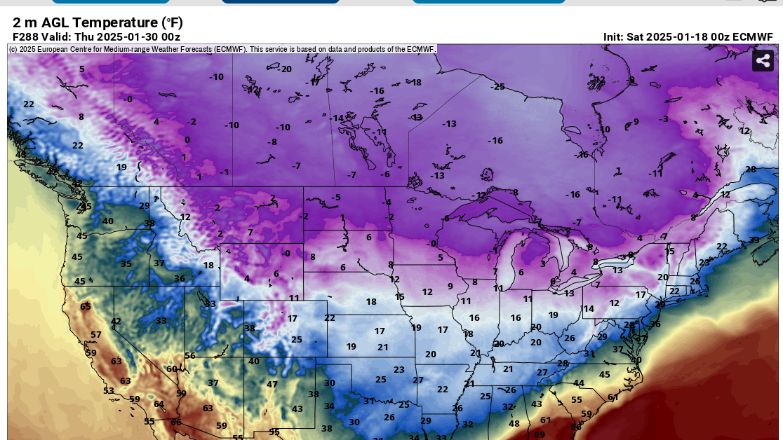
I am wondering the same thing honestly; while it is going to be cold, is it going to be 1899 or 1985 type cold? In the 1899 instance, it snowed in New Orleans but here in the TN Valley we were well below zero, I am not seeing that type of cold. How is modeling depicting things so far south?
-
The models are crazy! I mean, all of the stuff I have ever read about historical cold, for example, the 1899 outbreak when it snowed in New Orleans, we were really cold here in the TN Valley. From what I have seen, we are now where near that kind of cold, how is everything being depicted so far south?
- 207 replies
-
- 1
-
-
- obs
- light snow
- (and 2 more)
-
Well, after the cold next week, I will probably be looking more toward spring, realizing of course that February can offer some fun and games, we have already had a pretty good season by most standards forum wide so
-
All of Middle TN looked good on the last two runs of the GFS
-
Yea that is the way it was here in Sumner County. A friend of mine tried to get his cabin out at Center Hill Lake but the State Troopers had 40 closed I believe at Lebanon, just too many people stranded on the road evidently. I remember being able to look at the cedar trees for years after and being able to tell where the heaviest snows fell as their branches were still bent and or had whole sides gone.
-
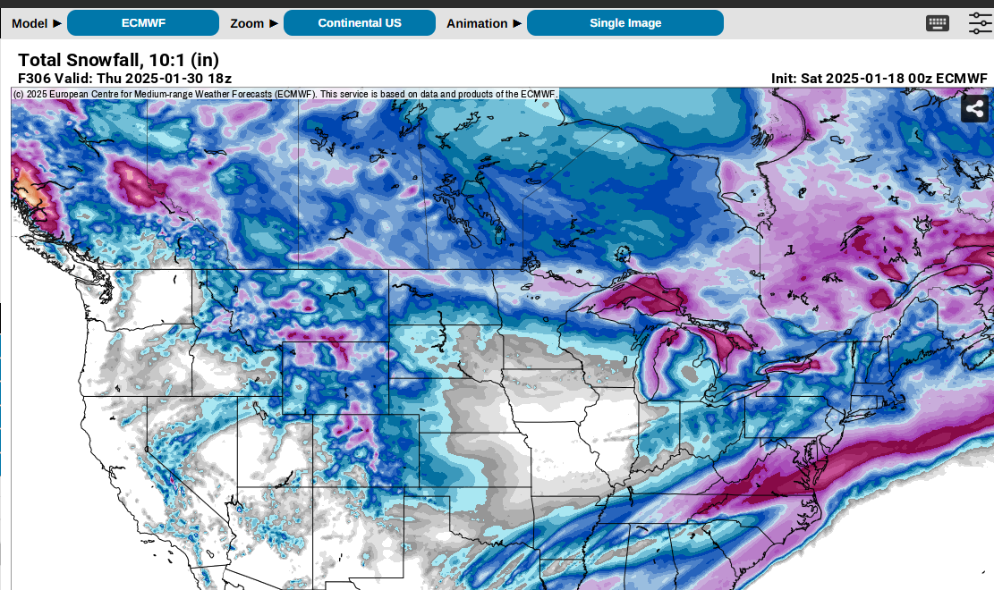
I think it is safe to say at this range that something is cooking for next week and likely have barbecue sauce! I cannot imagine someplace like Huntsville getting close to 20" of snow. This is like one of the only times I dont want to see a NW jog!
-
The CMC is a crushing blow to the state but I mean look at MS and AL, that would be state of emergency level.
-
We were on the outer edge here in Sumner county. I can only imagine what it must have been like to be in the thick of things. I remember it because was the only time I have ever seen snow fall in sheets from the sky and what fell was being blown around so much it was really hard to know how much had fallen.
-
Something that has always been of interest to me is roughly how far in advance did weather weanies know in March 1993, not that I am saying this is like that, but knowing what we do about modeling. I dont believe that weather forums were around back then as they are now, seems like I used to be on one at accuweather. My point is, if a similar system happened today, I cant help but think that it would initially be dismissed as an impossibility but then as we got closer....
-
Interesting solution, like you said, something to keep an eye on. My money is that it will be different next run!
-
Not sure that we want that; have not looked at any snow or temp maps but man those have to be brutal
-
Is that a tropical system coming into Florida at the end of the 18z run of the GFS? That is crazy!
-
The GDPS has been fairly consistent with a storm signal on the first of next week, but it, too, is gradually shifting northwest