

Winterweatherlover
-
Posts
1,109 -
Joined
-
Last visited
Content Type
Profiles
Blogs
Forums
American Weather
Media Demo
Store
Gallery
Posts posted by Winterweatherlover
-
-
2 minutes ago, LibertyBell said:
inland/elevated areas favored.
It would be interesting if this happened, we haven't had a clipper in a long time.
0.3 will tick cpk toward not breaking the record lol.
-
21 hours ago, binbisso said:
All the US models have snow for us. Nam, rap, hrrr and gfs. The euro/ukie and Canadians zippo

If those models are correct someone in a narrow area is going to get a nice surprise but i still think those are overdone. RGEM never came on board for this.
-
Models seem to have two waves now, one around 3/11 and a second stronger one around 3/13-3/14. A lot to sort out here.
-
 5
5
-
-
40 minutes ago, brooklynwx99 said:
UKMET is a nuke

Must be rain at the immediate coast based on the snow map but doesn't really matter this far out.
-
1
-
-
5 minutes ago, MJO812 said:
Caving also
Not really in my interpretation, this was 0Z, seems like it came west or at least is focusing on a different wave.
-
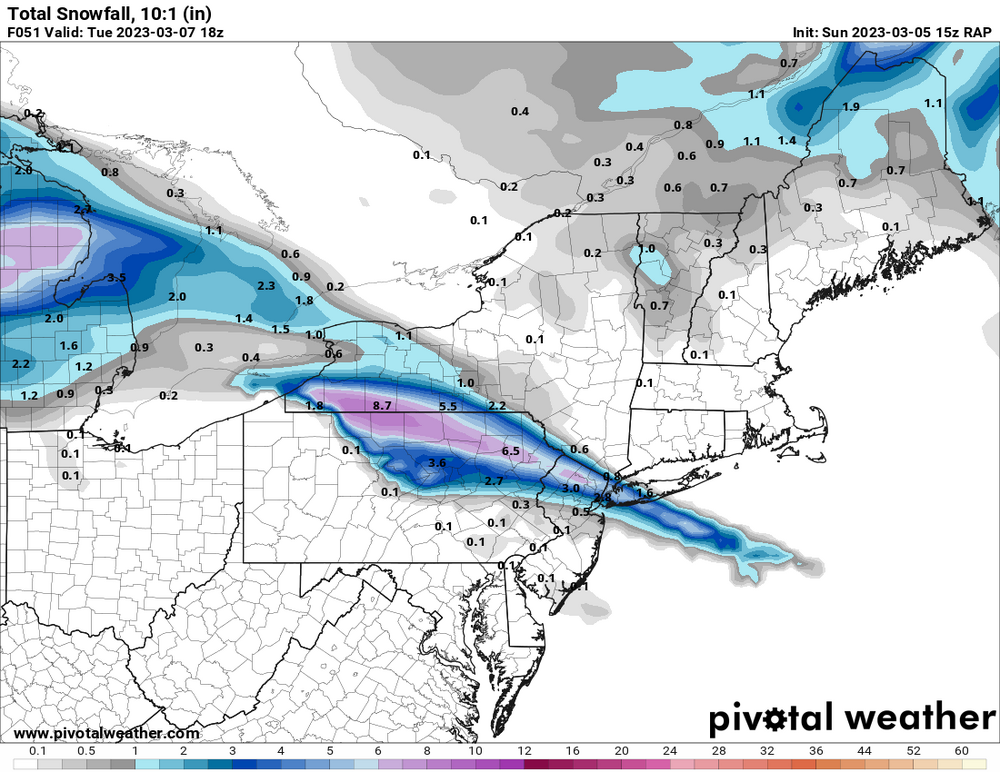
12z CMC cuts (I don't anticipate this being the outcome but presenting all possible solutions).
-
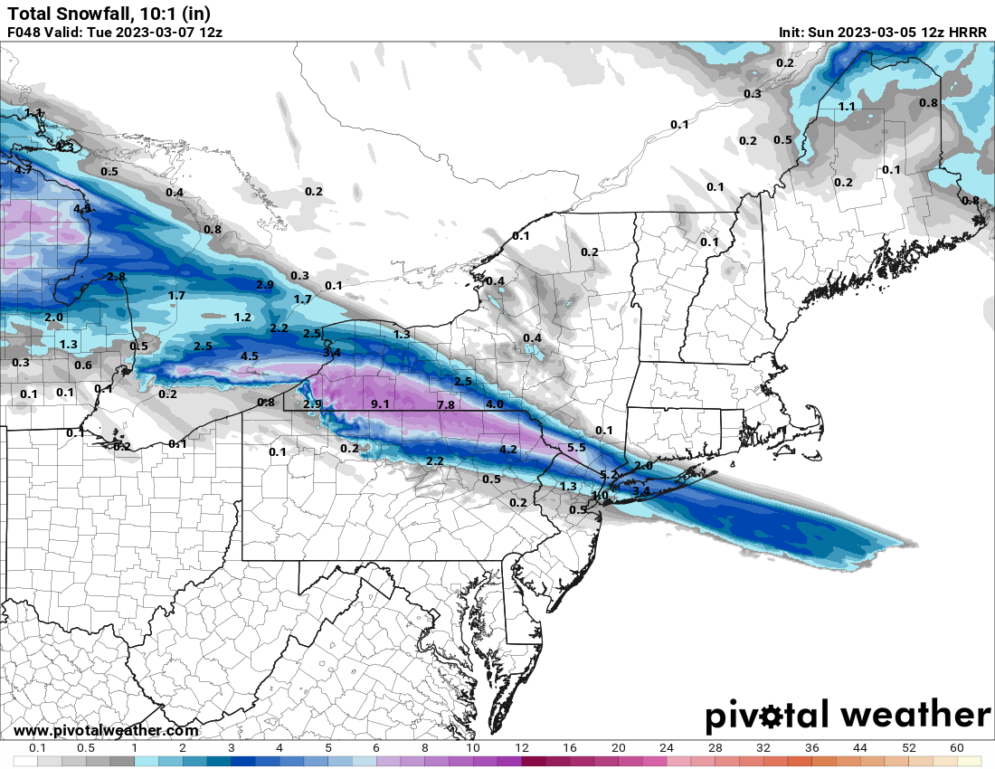
8 minutes ago, SnowGoose69 said:
Its a fairly massive outlier at the moment though...even the 12Z HRRR has something at 40-48
12Z Canadian has no interest either. I lean non event for now but am tracking it.
-
1
-
-
Not the euro but a massive trend toward it.
-
1
-
-
Here we go
-
3 minutes ago, MJO812 said:
Gfs caving
Yep this is either going to weak disorganized and flat or an East coast storm, this is not going to be a raging cutter.
-
Just now, brooklynwx99 said:
this event seems to come down to how zonal the Pacific jet is. the GFS is trending towards a more zonal Pacific jet, which helps boot the S/W out of the west instead of letting it dig. this is key to getting a coastal storm here
the trend is continuing on the 12z GFS... look at the E PAC ridge weakening and the increase in interaction between the S/W and ULL over the Pacific. look off of the CA coast. the increased strength of the PAC jet leads to a much weaker S/W this run


I’m not calling for a hecs but the gfs is probably going to cave this time and last time I said other models would probably cave to gfs. I think we either end up with significant east coast storm or a flat weak wave.
-
Just now, SnoSki14 said:
I need the mesos to come aboard for that one but it's possible the system is out of range for them.
I don’t like that the RGEM has no interest.
-
9 minutes ago, brooklynwx99 said:
not all events are the same. the GFS is clearly the outlier and will be treated as such
Agree the Ukie leans flat, the cmc is flat, the euro is a HECS and euro ensembles lean flat. GFS is most likely wrong.
-
23 minutes ago, snowman19 said:
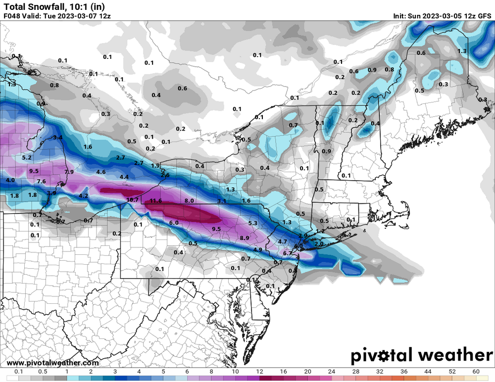
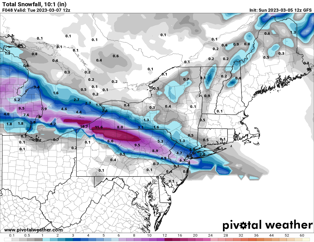
The RGEM has nothing at all. Zip zero. https://www.pivotalweather.com/model.php?m=rdps&p=snku_acc-imp&rh=2023030512&fh=84&r=us_ne&dpdt=&mc=&pwplus=1Yea I’m not interested in this unless the RGEM comes on board especially because it’s solution makes sense for clippers.
-
1 hour ago, MJO812 said:
Eps looks less amped than 0z

That’s ok. Would rather it be less amped til his far out.
-
31 minutes ago, SnoSki14 said:
Sneaky clipper with a southern lean. Euro actually misses us to the south with it.
Good overnight timing too
We haven’t had a clipper in a while. The question with clippers is will the moisture make it to the coast?
-
Still hard to believe that CPK received only 0.9 after midnight while parts of the Bronx got 3+ from that second batch. I'm still skeptical of the numbers being that low at CPK but I guess it's possible.
-
 1
1
-
-
42 minutes ago, tmagan said:
0.9" each day.
Sort of deceptive then but that is funny.
-
5 minutes ago, winterwx21 said:
12z Euro is rain for us next weekend. The 12z models didn't produce for us, but you can see the potential and a long way to go.
Similar to CMC the secondary develops too late, not a terrible look but as others have stated Miller B's are usually tough for us.
-
3
-
-
14 minutes ago, MJO812 said:
Ukie


Weak and flat is what you want to see at hour 168, not amped. However the Ukie is a terrible model lately.
-
2
-
-
4 minutes ago, snowman19 said:
I agree. This one is going the wrong way IMO. I don’t trust the Euro/EPS anymore. It’s definitely not what it used to beWay too far out still to say it's going anyway IMO. The ensembles look good and that's what matters more than OP runs at this point.
-
1
-
-
2 hours ago, LibertyBell said:
I would think it would be cooler here because of that darned ocean I hate so much lol
I think that comes into play more so in April.
-
1
-
-
Secondary on CMC but too weak/late unless you live in Boston.
-
 1
1
-
-
Baby steps on gfs at the surface the low went from Iowa/Minnesota border to Chicago.
I still think at best we are looking at a miller B scenario.


March 2023
in New York City Metro
Posted
I totally agree.