

Winterweatherlover
-
Posts
1,109 -
Joined
-
Last visited
Content Type
Profiles
Blogs
Forums
American Weather
Media Demo
Store
Gallery
Posts posted by Winterweatherlover
-
-
Hate to say it but I think RGEM will win this again. All models cut back at 0Z and the temps seem iffy where there is precip.
-
32 minutes ago, cleetussnow said:
Yes this place is asleep. I posted this in the NE forum. Good hit and good to see some op runs showing this kind thing again.
I think the fact the models are so all over the place and change run to run makes it hard to get too excited yet. Certainly there is big potential in the next week or so but hard to have high confidence in anything right now.
-
 1
1
-
-
Just now, mikem81 said:
Interesting to see the meso models bumbed slightly north and with more precip (.2-.3) in NYC. GFS also with similar amounts.
This would be the first major fail of the RGEM this winter that I can think of if the above happens.
-
2
-
-
4 minutes ago, MJO812 said:
Gfs had 2 coastals but misses us . 1st hits sne and 2nd close but offshore.
Interesting pattern ahead
The second one looks like it has KU potential if it comes west. Looking at both GFS/Euro Eastern NE is blasted.
-
2
-
-
Come 100 miles west and it would be boom, we really are dependent on dynamic cooling
-
1
-
-
OP GFS still amped and warm for the coast with storm 1. I lean toss given lack of support from other models and ensembles.
-
I hope it works out but for me it's still a caution that the RGEM has never been on board and is still not really on board.
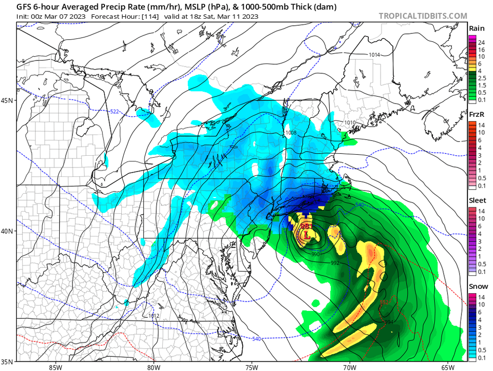
https://www.pivotalweather.com/model.php?rh=2023030618&fh=24&dpdt=&mc=&r=us_ne&p=sn10_acc-imp&m=rdps
-
1
-
-
5 minutes ago, CIK62 said:

Narrow cutoffs stink but nice to see the areas on the wrong side of the cutoff last week maybe cashing in.
-
25 minutes ago, SnoSki14 said:
Given the Euro solution we can probably rule out a cutter.
Yea suppression is more likely than a cutter with the first storm. Suppression for storm 1 shouldn't be terrible as it could pave the way for storm 2 as the Euro is showing. What we seem to absolutely not want is an amped up rainstorm for storm 1.
-
50 minutes ago, SnoSki14 said:
2" would be my biggest storm of the season. I only got 1.5" with the last one.
Current HRRR has 2-4" over the area. Clear meso banding showing up on some of the models.
Maybe a surprise positive bust for some
Yea I get that. I don't want to minimize it, I hope it works out for your area.
-
9 minutes ago, SnoSki14 said:
It's still a hugger. Need that primary to dig further south. Not a bad look right now though

That's not really a hugger.
-
1
-
-
One thing I don't love is even in a supposed great pattern coming up there seems to still be great lakes lows and I feel until we shake that it might be hard to get cold enough without threading the needle.
-
1
-
-
44 minutes ago, Dark Star said:
Talk about "threading the needle" The bullseye is central NJ like you said, but the width of the storm is extremely narrow. 1/8 of a degree (angle) will create a big-a-miss?
I tend to think the "bullseye" with this will be 2 inches max and more likely coating to an inch. NAM over juiced as it usually is imo. Clippers usually dry out as they come east.
-
1 minute ago, HeadInTheClouds said:
The models are struggling right now. Every model run is a different adventure. I don't think we start to see better consistency until mid week.
Yep no agreement between models or even run to run agreement in the same model. Agree this won't be sorted out until at least mid week.
-
Ukie must be surpressed for storm 1 because it hits Southern NJ coast. Models completely all over the place
-
My interpretation: GFS really strong with storm 1 so storm 2 is squashed to the southeast.
-
I’m so confused by this pattern I guess the models are too.
-
1
-
-
3 minutes ago, SnoSki14 said:
Looks like GFS/CMC both moved in a favorable direction
Agree like the look of offshore lows, just need one of them to trend stronger and west. Not a bad look at all this far out.
I was focused on cmc, just looked at gfs and the first wave is too far west for us.
-
2 minutes ago, LibertyBell said:
and we need a Miller B south of us, otherwise it's for New England like they normally are.
I could be naive but not too worried about that with this blocking, more worried about secondary being flat/suppressed.
-
1 minute ago, LibertyBell said:
why does it seem like no matter what the track this will be rain for us

Not necessarily but needs to be strong and close to the coast especially if it’s Miller B because that will initially pump warm air.
-
1 minute ago, brooklynwx99 said:
CMC completely caved to the ECMWF... total change in the synoptic evolution

It went from too far west to too Far East. It’s all over the place.
-
12z cmc is what happens if the storm is too weak and too Far East, no dynamics and rain at the coast.
Well mostly too Far East this run , it’s not weak.
-
2 minutes ago, nycwinter said:
snowman19 is like lucy always pulling the football away from charlie brown..
I like him pointing out the reasons it may not snow. It’s interesting to look at all angles. Plus if he’s quiet you know we might be looking at a legit threat.
-
1
-
-
8 minutes ago, snowman19 said:
I mean he’s not wrong. Going to need a fairly strong storm in March to get it done but that’s usually the case.
-
1
-


March 7th Clipper Disco/Obs
in New York City Metro
Posted
Barely anything here.