AtlanticWx
-
Posts
643 -
Joined
-
Last visited
Content Type
Profiles
Blogs
Forums
American Weather
Media Demo
Store
Gallery
Everything posted by AtlanticWx
-
synoptically, 3k nam and nam had colder 850s leading into event as a result of the confluence being handled significantly differently this run at this lead time starting from only 18 hours out hopefully this is a trend and something we see on all guidance tonight! nam was pretty close for my liking tho honestly
-
this is just a thought but shouldn't the snow stick almost immediately because of how cold the ground is from the two days of pretty cold temperatures along with those 20 degree DPs up until onset? why use snow depth
-
why are operational models so much stronger than ensembles?
-
https://x.com/AtlanticWx/status/1742383118823178693?s=20 At least some positives have come out of climate change
-
im confused, this run looked worse before it played out? what makes 18z gfs even better? am i missing some weird vort
-
Jan Medium/Long Range Disco: Winter is coming
AtlanticWx replied to stormtracker's topic in Mid Atlantic
i think the panic comes from the tight gradient and the fact that we're still so far out -
Jan Medium/Long Range Disco: Winter is coming
AtlanticWx replied to stormtracker's topic in Mid Atlantic
the trend for a faster storm is pretty evident here -
Jan Medium/Long Range Disco: Winter is coming
AtlanticWx replied to stormtracker's topic in Mid Atlantic
yeah i like seeing all that snow south of the fall line. but euro definitely scares me. while ik icon is shit, im just glad it shifted south -
Jan Medium/Long Range Disco: Winter is coming
AtlanticWx replied to stormtracker's topic in Mid Atlantic
i would like to see south shifts on the ensembles & models into 0z now. -
Jan Medium/Long Range Disco: Winter is coming
AtlanticWx replied to stormtracker's topic in Mid Atlantic
nope, op is a bit more NW than the ensembles
-
Jan Medium/Long Range Disco: Winter is coming
AtlanticWx replied to stormtracker's topic in Mid Atlantic
i like our chances here in the mid atlantic for once, we track -
Jan Medium/Long Range Disco: Winter is coming
AtlanticWx replied to stormtracker's topic in Mid Atlantic
18z eps control looks amazing btw, and it usually shadows the op. it looks like there's more cold and precip starts quicker. it looks colder than gfs at the very least 18z on top, 12z on bottom
-
Jan Medium/Long Range Disco: Winter is coming
AtlanticWx replied to stormtracker's topic in Mid Atlantic
feels like we're just setting up for an amazing late winter with all that snow cover we're setting rn -
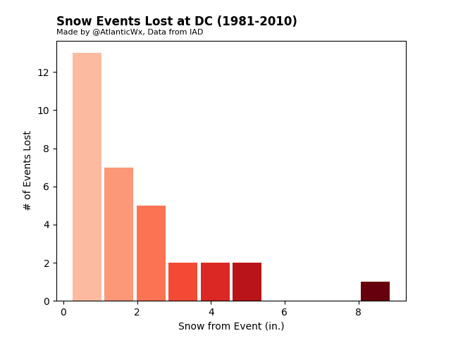
the 8" storm is the late feb 1983 snowstorm btw. it'd be a rainstorm today.
-
for fun, i did an analysis of the snow events we've lost due to climate change. the results were pretty surprising, but it wasn't as high as i thought it'd be. still alarming -- we're losing an average of ~1.1 snow events per year.
-
Jan Medium/Long Range Disco: Winter is coming
AtlanticWx replied to stormtracker's topic in Mid Atlantic
ICON would've snowed too damn, what made the 0z models change sm? sampling? -
Jan Medium/Long Range Disco: Winter is coming
AtlanticWx replied to stormtracker's topic in Mid Atlantic
ofc we'll see a +PDO again, it's a decadal oscillation so it usually flips every ~10 years or so -
Jan Medium/Long Range Disco: Winter is coming
AtlanticWx replied to stormtracker's topic in Mid Atlantic
exactly, like AGW is happening fast but i feel like especially in the forums it's exaggerated for how much of an effect it has. it still can snow, like on dec 11 when we got a T-3" area wide storm when we expected nothing in a pretty horrible pattern because it just came together perfectly i think while a lot of the snowlessness recently has to do w AGW & its effects, i also think its just really bad luck along w the -PDO worsening everything since 2016 -
Jan Medium/Long Range Disco: Winter is coming
AtlanticWx replied to stormtracker's topic in Mid Atlantic
i don't really get the sentiment across all the forums for canceling winter anyway. the mid point for major storms in ninos like these in the mid atlantic is early february. 75% of winter hasn't even started based off major storms by january 20th. we're fine -
Jan Medium/Long Range Disco: Winter is coming
AtlanticWx replied to stormtracker's topic in Mid Atlantic
wasn't this expected? mjo forcing is supposed to go into MC around this time isn't it? we're not in a nina, i don't really get the worry about some immovable SE ridge -
Jan Medium/Long Range Disco: Winter is coming
AtlanticWx replied to stormtracker's topic in Mid Atlantic
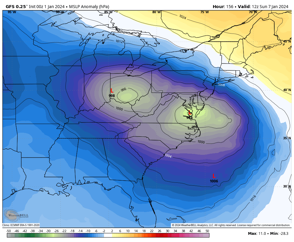
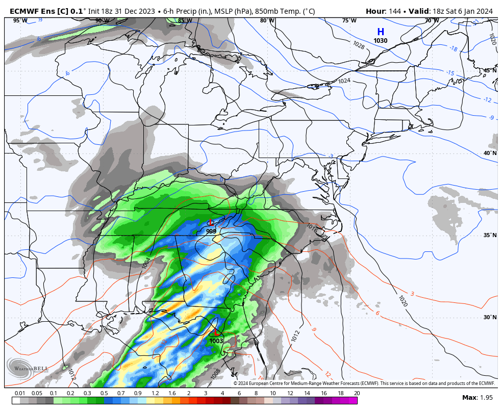
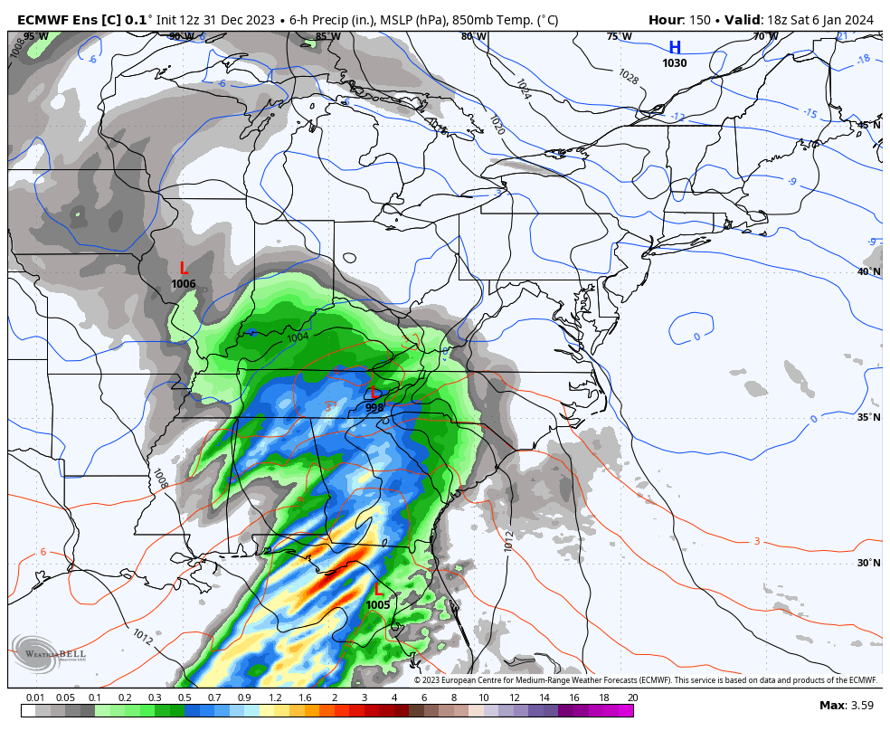
euro has an interior storm for this fwiw, i honestly like euro's progression altogether because it's really close to a good snowstorm on jan 7th. pretty nice look where all we're relying on is a single shortwave to go negative, and there being cold ofc -
all ensembles have trended colder in the long range. i suspect this is because of the trend away from the SSW and probably a weaker pass thru 4-5-6 MJO wise which ends up reducing the early signs of our SSW (like EC ridging). If these trends continue, we should be in the game for all of january
-
kuchera is even more LMAOO, it's like 5-6" extra bc it's that cold
-
isn't more NS a good thing?
-
lots of double negatives here, so you'll be surprised if we don't get something between now and january 10th?