

AtlanticWx
-
Posts
643 -
Joined
-
Last visited
Content Type
Profiles
Blogs
Forums
American Weather
Media Demo
Store
Gallery
Everything posted by AtlanticWx
-
At this range, a spread of ensembles that show cutters is fine. The changes that will determine what happens with our storm probably can't be resolved that well this far out (eg +PNA and the extent of it)
-
This threat looks exciting for our area tbh. The spread on the ensembles is good at this range, we don't exactly want to be in the bullseye.
-
There's no way areas Montgomery County, MD and NW don't close with this one. Lots of risk for ice and it just keeps uptrending.
-
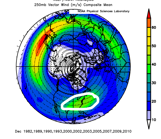
No problem! STJs are visible on 250mb wind speed plots, and usually they're identified by stronger winds in the SE winds, and while this plot does smooth out the mean wind speed since it's a monthly composite, you can generally see stronger winds south of us, indicating an active STJ (sub-tropical jet).
-
This pattern definitely looks favorable, but how does it compare to the biggest Decembers around here? Below is a plot of the mean snow-to-date climatologically in December from 1980-2021, along with the mean snow-to-date from the top 25% and bottom 25% Decembers snowfall-wise here in DC. Out of those top 25 Decembers snowfall-wise, here are the H5 anomalies plotted on the Northern Hemisphere for each of them. The key similarities to our upcoming pattern and the top 25% Decembers' average pattern around here are troughing near Hawaii/the Aleutians, a cutoff ridge north of AK and ridge bridging in the Arctic (-EPO/-AO/-NAO) and the elephant in the room -- lower heights over the EC. Below is a composite plot of the 250mb plots in these same years (do note that they are smoothed out since they're for the entire month, but you can still make out two key features): The two key features here are an active STJ and what seems to be a Pacific jet extension, which promotes a +PNA if I remember correctly. Our upcoming pattern seems to have an active STJ and a jet extension too, which is why we are expected to see a +PNA of some sorts during this pattern. Overall, our pattern has key similarities to some other patterns of conducive Decembers, snowfall-wise.
-
You can create the plot below at https://psl.noaa.gov/cgi-bin/data/composites/printpage.pl btw, but here's a map of Dec 1983 H5 anomalies. EDIT: Didn't see someone already posted it haha.
-
GEFS 250mb wind plot vs. composite of 250mb winds around or during some of our biggest hits around DC. Can see a few similarities. Exciting pattern coming up, just need to see if anything materializes out of it.
-
Do you really want to be in the bullseye this far out? We're essentially 10 days out lmao, why are we worrying about its outcome
-
500mb looked a lot better lmao, what happened?
-
Why are we looking at and freaking out over what 18z GFS shows lmao, one OP going way out. By that logic, we should worry about every single fantasy snowstorm ever! The pattern looks great going into Christmas and maybe into January, not really any cause for concern rn
-
I'm talking about the position of the secondary low, not the primary low.
-
Same, the track looks great. Just need cold
-
Unfortunately, no good hits lmao
-
We have a pretty strong high to our north with CAD which is usually undermodeled so the cold air at the surface does come from a decent source. But yeah, I don't think we get a purely snow event, but a wintry mix -> snow and maybe some rain is definitely plausible.
-
Honestly, I can't believe I'm saying this, but this is one of the nicer setups here in a sense. A lot of our threats are usually thread-the-needle/one phase can mess up the whole storm kind of storm, but this one is just us relying on one trough and its track. Cold is there associated w/ the trough, just need a good track. The better track (06z GFS yesterday/00z Euro) would definitely fare well here.
-
Probably the first day I haven't looked at ensembles for the LR pattern lmao, pattern chasing got boring after a while.
-
It is at the very end of its run to begin with and GEFS and GEPS both agree in a poleward ridge supporting a -EPO/+PNA to neutral PNA GEFS and GEPS connect the troughing between Hawaii and the Aleutians, sending the ridge further west and more poleward (better for us, more Pac ridging) while EPS fails to "bridge" them resulting in an okay but unfavorable positioning of the -EPO ridge. I wouldn't be worried, right now at least.
-
December-wise, what came up in my program was December 1967 and December 1996. Both of these had a pretty stout -PNA though so not sure if it's the best analog. Snow totals for both months at KIAD were 4.9" and 1.9" respectively.
-
Lmaoo dw about it, probably can't kick the can any further
-
13 days out? ridge bridge showing up within 7 days
-
Research has shown that the "big dogs" in the East Coast typically happen when the -NAO begins to weak, and besides it looks to strengthen again so not really that worried.
-
That threat on the 10th is beginning to look more and more favorable for our area. 18z EPS/EPS Control/ECMWF all shifted south w/ more cold.
-
Wow.
-
TBF, CMC/ICON both show suppressed & colder solutions and Euro's trending colder; GFS is just on an island here.
-
EPS/Euro really trending in the right direction for that threat on the 10th.


