AtlanticWx
-
Posts
643 -
Joined
-
Last visited
Content Type
Profiles
Blogs
Forums
American Weather
Media Demo
Store
Gallery
Everything posted by AtlanticWx
-
it's not a banger by any means but if we look at the glass half full, i'd take this run.
-
let's see gefs but if we get one more cold shift like this (12z -> 18z) we'll likely have atl some snow to start off with
-
this run is DEFINITELY an improvement. snowing in western areas at 135
-
i take that back, p major changes in the orientation of the NS. looks more meridional than 12z which was elongated from W/E.. looks p interesting
-
NS looks more held back, idk if we're gonna like this
-
really? this run looks pretty similar to before imo
-
hour 81, our big-scale features look better so far. blocking comes in faster, whatever semblance of low 50/50 heights we have seems stronger, and that piece that eventually comes in the west and messes w our trough seems more held back
-
hour 66, that wednesday storm is fairly south on the gfs looks like a euro cave, wondering what implications this is gonna have on our storm
-
i always switch to pivotal weather for PBP, WB is slower before hour ~144 tbh
-
interesting how the same camps snow-wise for the 28th storm are applicable for the 4th storm. for example euro & cmc are both colder and south for the 28th storm in comparison to gfs. i imagine we'll have to wait a few days to see how that storm plays out so we understand how the next storm plays out
-
this is honestly gonna be one of the last if not the last storms to track for the season (as if we've had any) so idk ab you guys but i'm gonna have fun tracking this HH GFS frame by frame analysis who's with me
-
when was this dicsussion posted? bc as of now, both EPS and GEPS show a pretty perfect track in terms of how the NS doesn't outpace or get held back and phase with the SS.
-
-
fwiw the top 25% of members' snowfall within eps, gefs and gefs respectively
-
Holy shit, can't recall such a signal from EPS at all this winter
-
eps w lower heights and a bit colder than 00z
-
even tho the temperatures are in the mid 30s kuch output is actually higher bc of how good the upper levels are - awesome to see! just worried that euros continue to go nw
-
geps went crazy
-
i'm liking where we're at rn - seems like with every single storm this year the CMC/EURO/ICON camp wins
-
chances of 1" way up on 12z gefs
-
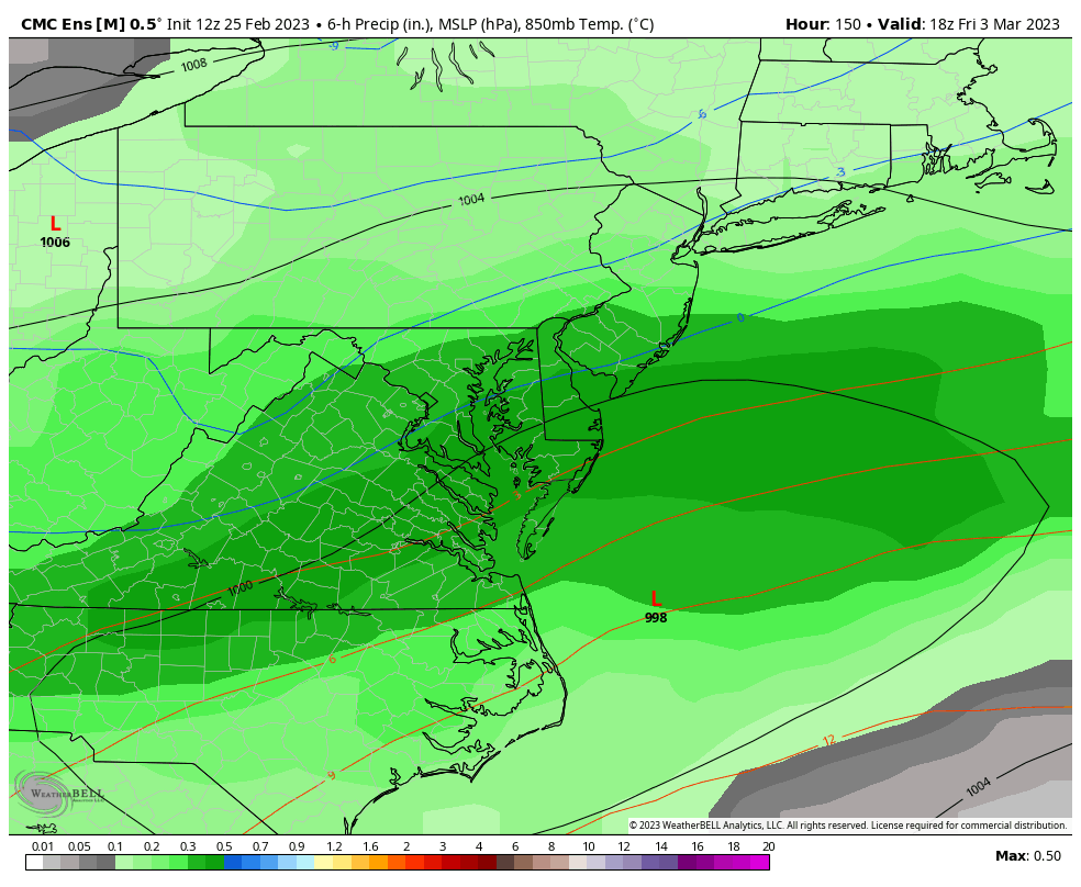
the vast majority of snow on each of these is from the march 3-4 threat, really good signal rn.
-
if this were to happen verbatim, rates would be extremely heavy given the vigorous S/W and we have a good cold source to our north so we wouldn't rlly ahve to worry ngl
-
it sleets on one frame for south of dc only lmao, rlly robust
-
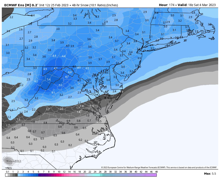
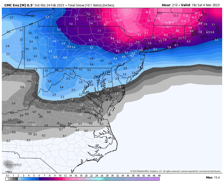
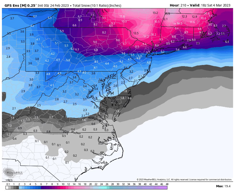
was waiting for someone else to post it but ig i will, 20" of snow from that march storm
-
Late February will be rocking. February Long range Discussion thread
AtlanticWx replied to Ji's topic in Mid Atlantic
honestly i'm glad everything's trending warmer, i'm tired of wishing for a winter we're never gonna have. we'll have better luck next winter, it's been so nice out recently so i dont mind the torch