AtlanticWx
-
Posts
643 -
Joined
-
Last visited
Content Type
Profiles
Blogs
Forums
American Weather
Media Demo
Store
Gallery
Everything posted by AtlanticWx
-
i think that's where the negativity around this pattern comes from. lots of deja vu especially bc the pattern looks really good around this time last year
- 1,295 replies
-
- 1
-

-
- wishcasting
- almost winter
- (and 1 more)
-
maybe we'll get an early start to the ski season
-
where?

- 1,295 replies
-
- 5
-
-
- wishcasting
- almost winter
- (and 1 more)
-
this is how u do it in december
- 1,295 replies
-
- 10
-
-
- wishcasting
- almost winter
- (and 1 more)
-
bwi: 38.2" iad: 41.3" dca: 31.0" ric: 24.8" tiebreaker (sby): 13.5"
-
you will never find a crazy pronounced ridge on a 7 day mean that far out on the weeklies
- 1,295 replies
-
- 4
-
-

-
- wishcasting
- almost winter
- (and 1 more)
-
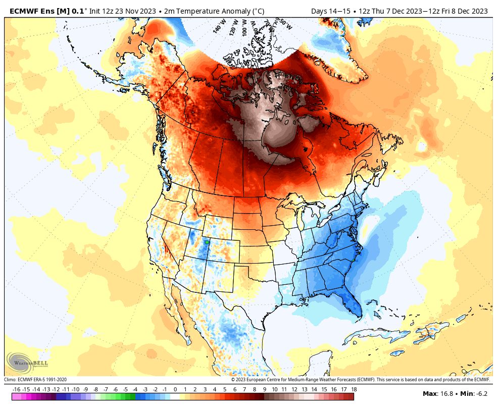
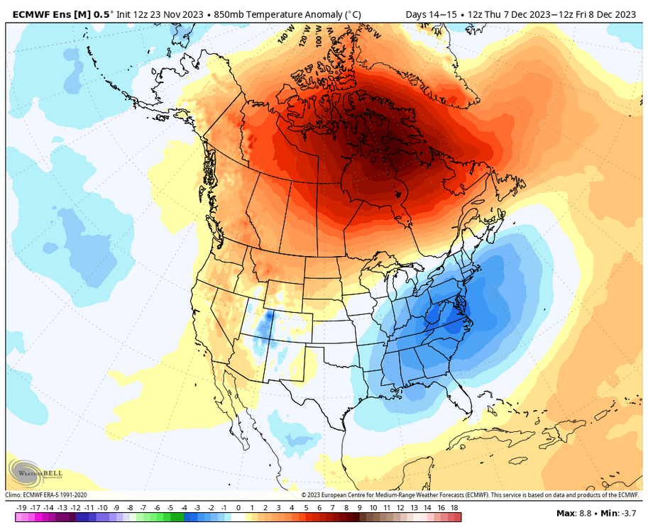
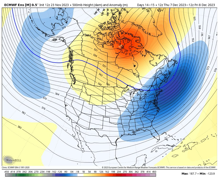
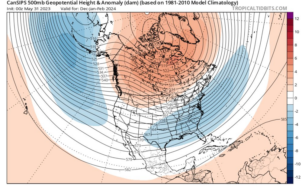
that's a GOA low, which is a classic feature of Ninos. look at the height lines which point upwards over Idaho, that's a decent signal for a ridge in the west this far out with all the smoothed means. i think you need to let go of whatever nina base state panics ur having bc now we're in a solid nino
- 1,295 replies
-
- 2
-
-
- wishcasting
- almost winter
- (and 1 more)
-
-PNA/-NAO is really good for some CAD storms tho. p easy way to score in december if timed right
-
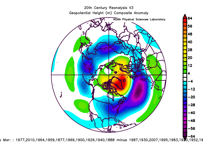
per eric webb, here's a plot of the JFM difference between the 10 most negative NAOs during december vs 10 most positive NAOs during december. using statistical t-tests, he found a significance of 98% between the two datasets showing that a december -NAO during a nino can go a long way for the rest of the season. take 2009-10 for example which had a crazy december -NAO, which set us up for the monster winter to come. most long range models right now have a sustained -NAO going into december, and while the gefs extended has a +NAO, the gefs has been trending towards a much more sustained -NAO (esp 12z which made a huge nod to CMC/Euro weeklies), so going off of this correlation which has actual statistical significance (~98%) unlike other metrics this board has been using, if we get a -NAO that's sustained throughout December, this winter should turn out pretty cold and possibly snowy too.
- 1,295 replies
-
- 9
-
-
- wishcasting
- almost winter
- (and 1 more)
-
i feel like there's more of a correlation w/ the cold rather than the snow. like i think it'd be worth looking into if somebody looks at how winters turn out if it's cold in november/early dec since you won't always get snow w/ cold in the early season, especially with AGW where we get near perfect track rainstorms in the early season
-
genuine question, how does whether or not PSU gets an inch or not soon have any bearing on how this winter is gonna go? stats can say what they wanna say, but is there really a causation to the correlation that's significant
-
j for shits and giggles
- 1,295 replies
-
- 4
-
-
- wishcasting
- almost winter
- (and 1 more)
-
that's true but it's pretty much guaranteed when you have that type of signature and u have a whole tpv lobe coming down with a storm
-
The fact that we already have a trackable period with guaranteed cold and it being the question of precipitation being there shows how different this year will be from other years. Can't believe we already can watch models in November.
- 1,295 replies
-
- 11
-
-
- wishcasting
- almost winter
- (and 1 more)
-
Out of curiosity, what statistical methods did you use/if you created a script to calculate these statistics, would you be able to post it?
-
for fun
-
damn
-
SNOD maps which typically downplay snow have like 1" in immediate suburbs (Leesburg/MOCO) lmao, that isn't white rain
-
euro looks solid -- did take a step back but totals around suburbs remain the same prob bc of better banding
-
18z has been out since 6 pm lmao
-
March Medium/Long Range Thread: The Empire Strikes Back
AtlanticWx replied to stormtracker's topic in Mid Atlantic
gefs looks pretty crazy now. like 5" mean by hour 330 -
March Medium/Long Range Thread: The Empire Strikes Back
AtlanticWx replied to stormtracker's topic in Mid Atlantic
the march 3rd storm -
March Medium/Long Range Thread: The Empire Strikes Back
AtlanticWx replied to stormtracker's topic in Mid Atlantic
-
March Medium/Long Range Thread: The Empire Strikes Back
AtlanticWx replied to stormtracker's topic in Mid Atlantic
yeah the ceiling for this weekend storm is 3-5". latest eps 90th percentile maps for the weekend have a regionwide 3-4" -
March Medium/Long Range Thread: The Empire Strikes Back
AtlanticWx replied to stormtracker's topic in Mid Atlantic
i feel like in times we were in a bad mjo phase models trended warmer as soon as it initialized in said phase so i wonder if the same applies here