

DarkSharkWX
-
Posts
667 -
Joined
-
Last visited
Content Type
Profiles
Blogs
Forums
American Weather
Media Demo
Store
Gallery
Everything posted by DarkSharkWX
-

1/19 - The Roulette Wheel 29 Black Storm - OBS
DarkSharkWX replied to DDweatherman's topic in Mid Atlantic
32 on the dot and SN+ in gaithersburg! has to be the heaviest rates since feb 2024 last year when i got 2" in an hour -
1/19 - The Roulette Wheel 29 Black Storm - OBS
DarkSharkWX replied to DDweatherman's topic in Mid Atlantic
nws raised totals?? interesting -
1/19 - The Roulette Wheel 29 Black Storm - OBS
DarkSharkWX replied to DDweatherman's topic in Mid Atlantic
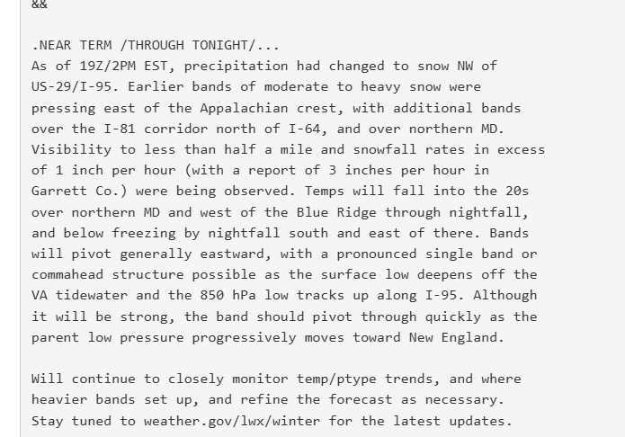
-
1/19 - The Roulette Wheel 29 Black Storm - OBS
DarkSharkWX replied to DDweatherman's topic in Mid Atlantic
32.8 despite very low precip and all snow, temps arent much of an issue here anymore though i would like it to go all the way down lol -
1/19 - The Roulette Wheel 29 Black Storm - OBS
DarkSharkWX replied to DDweatherman's topic in Mid Atlantic
0.25" on the board in gaithersburg! -
1/19 - The Roulette Wheel 29 Black Storm - OBS
DarkSharkWX replied to DDweatherman's topic in Mid Atlantic
32.9 rn in gaithersburg, eyeballing 0.1-0.2 -
1/19 - The Roulette Wheel 29 Black Storm - OBS
DarkSharkWX replied to DDweatherman's topic in Mid Atlantic
puking here with bigger flakes, 33.1 -
1/19 - The Roulette Wheel 29 Black Storm - OBS
DarkSharkWX replied to DDweatherman's topic in Mid Atlantic
33.3 with a dusting -
1/19 - The Roulette Wheel 29 Black Storm - OBS
DarkSharkWX replied to DDweatherman's topic in Mid Atlantic
huge flakes, temps dropping quick, current 34.5 -
1/19 - The Roulette Wheel 29 Black Storm - OBS
DarkSharkWX replied to DDweatherman's topic in Mid Atlantic
my friend in oakton says its starting to stick to cars, awaiting the band here -
1/19 - The Roulette Wheel 29 Black Storm - OBS
DarkSharkWX replied to DDweatherman's topic in Mid Atlantic
whats ur elevation? -
1/19 - The Roulette Wheel 29 Black Storm - OBS
DarkSharkWX replied to DDweatherman's topic in Mid Atlantic
https://x.com/iembot_lwx/status/1881012605625553237 -
1/19 - The Roulette Wheel 29 Black Storm - OBS
DarkSharkWX replied to DDweatherman's topic in Mid Atlantic
new sterling AFD: As of 16Z/11AM EST, precipitation continued to expand across the Mid-Atlantic. A tight gradient in air temps had developed from roughly Norrisville MD southwest to Wintergreen VA. NW of this line, temps were roughly 31-33F with mainly snow (light accums observed); SE of this line was in the mid to upper 30s with a mix of rain, sleet, and snow (little to no accums yet). Over the Appalachians, bands of moderate to heavy snow had developed dropping visibility to less than half a mile; temps over the higher terrain in these areas were in the 20s. Freezing levels were continuing to drop per recent ACARS as well as dual-pol data from KLWX. KPBZ/KFCX radars shows moderate to heavy snow banding pivoting E/SE toward eastern WV/western MD. Colder temps/bands of heavier precip are expected to press E/SE through the day, eventually reaching the metros by 2-3PM. -
1/19 - The Roulette Wheel 29 Black Storm - OBS
DarkSharkWX replied to DDweatherman's topic in Mid Atlantic
you didnt get all snow earlier? im 5-10 miles south of you and i was all snow for a bit, although its very light drizzle now flakes come back immediately once theres some precip heading in -
1/19 - The Roulette Wheel 29 Black Storm - OBS
DarkSharkWX replied to DDweatherman's topic in Mid Atlantic
i mean it was slightly warmer than expected in the morning but there was barely any snow expected east of the mountains for the morning, esp closer to DC, and everything else looks on track with the cold coming in -
1/19 - The Roulette Wheel 29 Black Storm - OBS
DarkSharkWX replied to DDweatherman's topic in Mid Atlantic
sterling says no reason to change forecast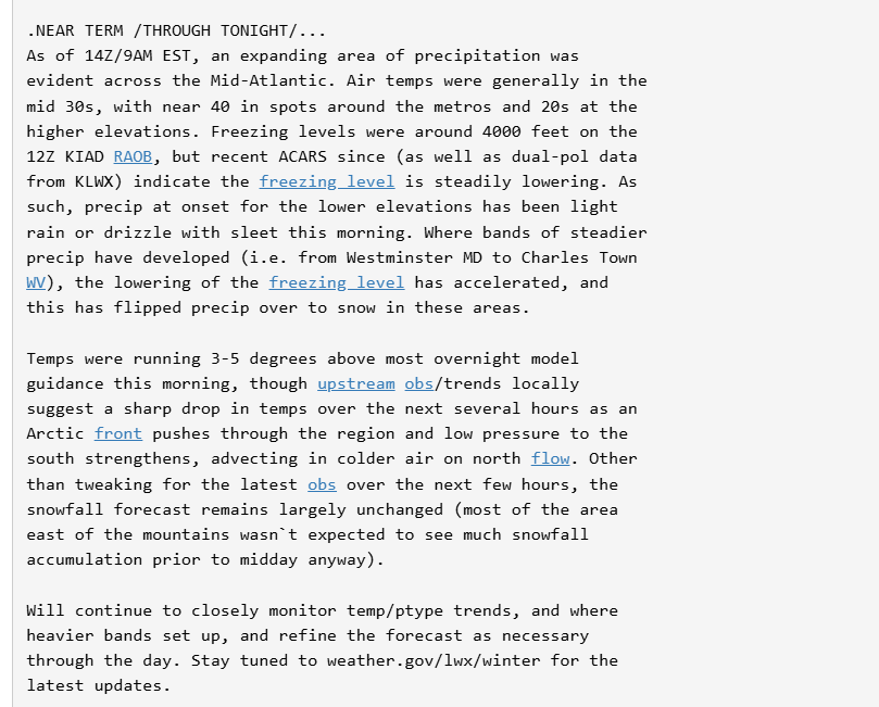
-
1/19 - The Roulette Wheel 29 Black Storm - OBS
DarkSharkWX replied to DDweatherman's topic in Mid Atlantic
igu -
1/19 - The Roulette Wheel 29 Black Storm - OBS
DarkSharkWX replied to DDweatherman's topic in Mid Atlantic
lmaooo still digging out from the 40" RGEM gave me in 2021 -
1/19 - The Roulette Wheel 29 Black Storm - OBS
DarkSharkWX replied to DDweatherman's topic in Mid Atlantic
-
HRDPS nice jump se as well
-
rgem shifted SE
-
January Medium/Long Range: A snowy January ahead?
DarkSharkWX replied to mappy's topic in Mid Atlantic
same shifts seen on EPS so makes sense that more members come up the coast.thumb.gif.3139df06500d5b204a5fb305fd521b16.gif)
-
January Medium/Long Range: A snowy January ahead?
DarkSharkWX replied to mappy's topic in Mid Atlantic
hmmm -
January Medium/Long Range: A snowy January ahead?
DarkSharkWX replied to mappy's topic in Mid Atlantic
-
January Medium/Long Range: A snowy January ahead?
DarkSharkWX replied to mappy's topic in Mid Atlantic
nod to cmc


.gif.6bbe8e9488d67a76f470828b2244866e.gif)