

DarkSharkWX
-
Posts
695 -
Joined
-
Last visited
Content Type
Profiles
Blogs
Forums
American Weather
Media Demo
Store
Gallery
Everything posted by DarkSharkWX
-
almost all snow now, temp still dropping crazy, 34.7/34.3
-
35.8 snow mixing in gburg
-
36.1 was mixing flakes here again gburg
-
36.9/36.5 rn
-
mangled flakes are starting to mix in here at gburg 530'
-
mix has made it to south of sterling/ashburn, should transition soon for ppl over there
-
is it true its mixing in leesburg rn?
-
temp rapidly dropping, 45 now
-
CF on radar and spc analysis E of I81, slightly ahead of models
-
fwiw it seems nam initalized too positively tilted(its held back) and less consolidated than it act is, as well as the obs being more held back w the system
-
oh wait mb converted utc wrong
-
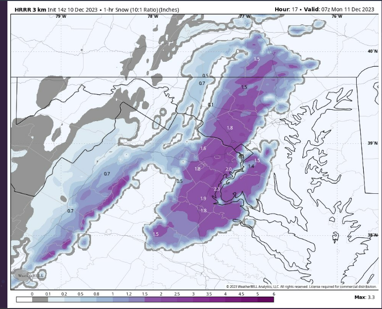
new hrrr is nice, switches NW of 95 by midnight/just after
-
for kgai its between 11pm and 12am
-
HREF has many of us NW of 95 switching to snow before midnight, not sure how good it is w winter
-
WWA/WSW for western areas
-
hrrr both nams absolutely cooked we see changes in NS strength and orientation(more N-S, what we want), and overall they dug more and had the same tilt or more negative can also start to see some of the deformation banding on them, all have a 3 hr period of thumping snow NW of 95 with nam verabritm likely popping 3h of blizzard conds
-
-
verabritm temps are 32-33 here when theres 35 dbz snow thats def sticking and once we have a coating otg everything else will accumulate
-
nam... trended more positive, better NS, less postilted, more amped
-
on water vapor imagery northern stream looks more amped and quicker than modeled, this is good and would make our sw negatilt faster downstream as well provide more cold air the disturbance in S Canada that extends into N border of US is the NS
-
nam 12k still looks good, 500mb wise i think they both improved, slightly more held back but same tilt and more amped 12k northern and southern jet was considerably more amped
-
this really isnt an anafrontal event anymore, the reason why we're getting sm snow on recent runs is bc of a secondary coastal low forming and undergoing surface cyclonegenesis which throws moisture nw back into the cold sector, this isnt cold front trying to catch up to precip
-
prob some convective feedback issues w banding, 500 was better, more amped, less positilted, and better interaction w ns should have allowed for more moisture and better cold
-
verabritm this would dump and stick, sounding reveals lift within dgz and saturated column as well as rapidly veering winds indicating strong fronto
-
nam to say the least cooked nam 3km wraps around low causing moco deformation baand


