DarkSharkWX
-
Posts
695 -
Joined
-
Last visited
Content Type
Profiles
Blogs
Forums
American Weather
Media Demo
Store
Gallery
Everything posted by DarkSharkWX
-

Jan Medium/Long Range Disco: Winter is coming
DarkSharkWX replied to stormtracker's topic in Mid Atlantic
what a suite -
Jan Medium/Long Range Disco: Winter is coming
DarkSharkWX replied to stormtracker's topic in Mid Atlantic
happy new year everyone -
Jan Medium/Long Range Disco: Winter is coming
DarkSharkWX replied to stormtracker's topic in Mid Atlantic
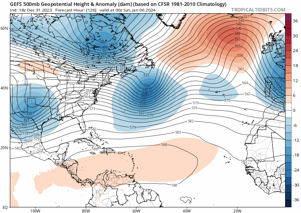
stronger 50/50 and slightly faster vort so far
-
Jan Medium/Long Range Disco: Winter is coming
DarkSharkWX replied to stormtracker's topic in Mid Atlantic
another cad thump on gfs lmfao -
Jan Medium/Long Range Disco: Winter is coming
DarkSharkWX replied to stormtracker's topic in Mid Atlantic
KGAI on northward it seems 10"+ verabritm tight ass gradient, one small tick south and thats 12-18" NW of 95 for many -
Jan Medium/Long Range Disco: Winter is coming
DarkSharkWX replied to stormtracker's topic in Mid Atlantic
icl people who canceled winter in a nino winter before new years are not looking good rn -
Jan Medium/Long Range Disco: Winter is coming
DarkSharkWX replied to stormtracker's topic in Mid Atlantic
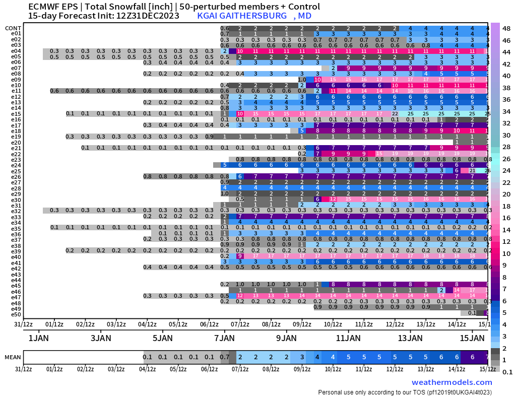
i know its snow mean but EPS at end of run looks really good, 7" snow mean and >30% chance NW of the fall line for over 6"
-
Jan Medium/Long Range Disco: Winter is coming
DarkSharkWX replied to stormtracker's topic in Mid Atlantic
nah i doubt so, this was a better run and snow came a lot closer to coast, just W of fall line verabritm gets frontend snow -
Jan Medium/Long Range Disco: Winter is coming
DarkSharkWX replied to stormtracker's topic in Mid Atlantic
western trough was weaker and more held back and 50/50 was a lot stronger, big step in right direction we were close -
Jan Medium/Long Range Disco: Winter is coming
DarkSharkWX replied to stormtracker's topic in Mid Atlantic
verification scores are 2nd just behind euro ahead of cmc and gfs -
Jan Medium/Long Range Disco: Winter is coming
DarkSharkWX replied to stormtracker's topic in Mid Atlantic
ukmet looks good, cold and south less amped than 0z -
Jan Medium/Long Range Disco: Winter is coming
DarkSharkWX replied to stormtracker's topic in Mid Atlantic
the 50/50 low is going to help but i think the biggest concern is the west coast trough crashing in way too early and sending the low too NE, thats what happened this run despite the 50/50 looking stronger(at least initally) -
Jan Medium/Long Range Disco: Winter is coming
DarkSharkWX replied to stormtracker's topic in Mid Atlantic
1011 mb --> 1002mb, pretty sig shift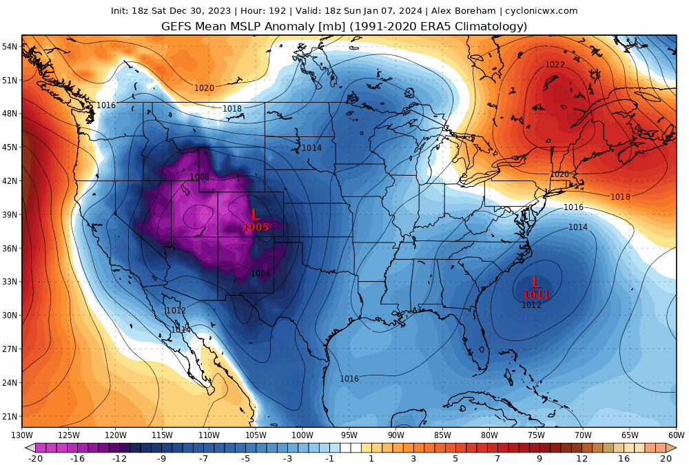
-
Jan Medium/Long Range Disco: Winter is coming
DarkSharkWX replied to stormtracker's topic in Mid Atlantic
What a run -
Jan Medium/Long Range Disco: Winter is coming
DarkSharkWX replied to stormtracker's topic in Mid Atlantic
euro was a nice step forward, much colder this run -
Jan Medium/Long Range Disco: Winter is coming
DarkSharkWX replied to stormtracker's topic in Mid Atlantic
webb counts basin wide events as EP, although they are different, basin wide events are considered EP in literature which is what he counts them as -
Jan Medium/Long Range Disco: Winter is coming
DarkSharkWX replied to stormtracker's topic in Mid Atlantic
since this is not a pure modoki nino and considering the warm SSTS in MC/IO as well as dateline, there will be periods of MC forcing(mid jan), u aren't going to get 4 months straight of favorable nino forcing in 8/1/2/3 in a basin wide nino -
Jan Medium/Long Range Disco: Winter is coming
DarkSharkWX replied to stormtracker's topic in Mid Atlantic
not really, the lack of true cold air was underestimated yes but there is enough cold air for it to work, even if marginal you just cant make defintive conclusions when its 8 days out and it can trend either way the pattern itself is pretty decent for something, getting cold air is possible but its gonna have to depend on some luck thread the needle but its def possible -
Jan Medium/Long Range Disco: Winter is coming
DarkSharkWX replied to stormtracker's topic in Mid Atlantic
jan 7th isnt even determined yet lmfao, and u cant say for sure that we wont get lucky again during mid jan or earlier/later even if the pattern is bad, the pattern was absolutely horrible for dec 11th and there was a decent area of 1-3"+ for parts dc metro this seems to be following this very well rn -
Jan Medium/Long Range Disco: Winter is coming
DarkSharkWX replied to stormtracker's topic in Mid Atlantic
did u forget the T-3"+ event we had in early dec, and early jan is still not determined yet wrt to Jan 7th(8 days out) most people's forecasts are going as expected right now any concern for late jan onwards won't be nina forcing/type pattern but rather if jet gets overextended again ur just going to have to be patient -
Jan Medium/Long Range Disco: Winter is coming
DarkSharkWX replied to stormtracker's topic in Mid Atlantic
its really not that deep, the MJO is going to return to unfavorable phases(4/5/6) and therefore it retracts the jet thus, we see the western trough/slight eastern ridge pattern setting up along with an -NAO(will prevent us from being super warm) and as for concerns about slowed IO forcing, thats just going to be a byproduct of a weakening +IOD increasing convection in that area, we will eventually make it to 8/1/2, 30C+ ssts remain in both MC/IO and dateline -
Jan Medium/Long Range Disco: Winter is coming
DarkSharkWX replied to stormtracker's topic in Mid Atlantic
you do realize a mid jan warmup was expected by most right? i understand the angst about early jan(assuming it fails) but a warm/wet dec and a transitionary jan was generally expected i wouldnt be too surprised if we see a 2016 type scenario where its just too warm w the airmasses for early jan and then the snowcover/cold rebuilds in mid jan for late jan and onwards, this is progressing as expected imo -
Jan Medium/Long Range Disco: Winter is coming
DarkSharkWX replied to stormtracker's topic in Mid Atlantic
not as it seems but this looks somewhat similar to the period we're having in mid jan w/ the western trough dumping, happened right before the KU and slid under the block -
Jan Medium/Long Range Disco: Winter is coming
DarkSharkWX replied to stormtracker's topic in Mid Atlantic
we are following the jan 2016 progression right now, but maybe around a week earlier patience is needed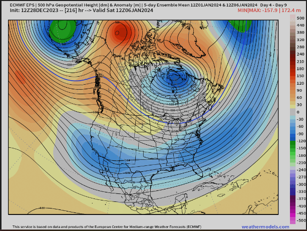
-
Jan Medium/Long Range Disco: Winter is coming
DarkSharkWX replied to stormtracker's topic in Mid Atlantic