Benjamn3
-
Posts
187 -
Joined
-
Last visited
Content Type
Profiles
Blogs
Forums
American Weather
Media Demo
Store
Gallery
Everything posted by Benjamn3
-
I am watching it put it down. Took a few rips off the Pen Griffey JR . 29 and heavy snow in my back yard. This is certainly nice.
-
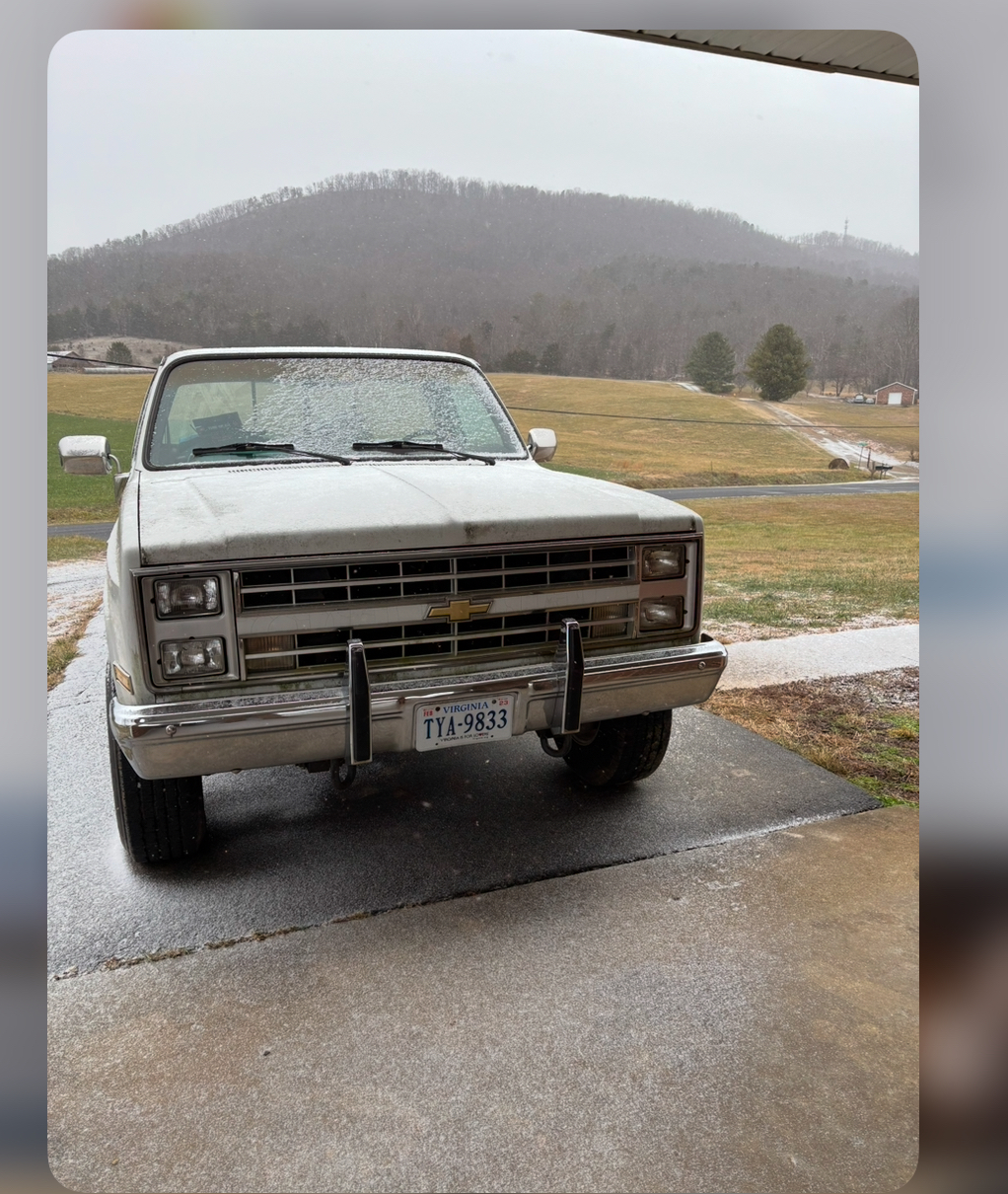
Thank you all for the compliment on my square body truck. She needs a bath but runs like a top. The interior is in great condition and it’s 98% rust free. So she goes no where near the salt. 87 K20 with a 350. Only 75k original miles.
-
Eagle rock Va
-
Coming down good.

-
32 and snowing in Eagle rock! Started early! Hopefully it helps us squeak out a little more before the change
-
36 with a dew point of 9 and it’s cloudy. 6ish mph winds out of the west. Eagle Rock, VA. Northwest of Roanoke.
-
My golden retriever too. She will saunter about a mile before she’s ready to just lay in the snow. Lol
-
I will be gladly taking my 3-5, with an icy chromed out finish (insert picture of Paul wall) swisher house baby. Let’s keep next weekend further south tho.
-
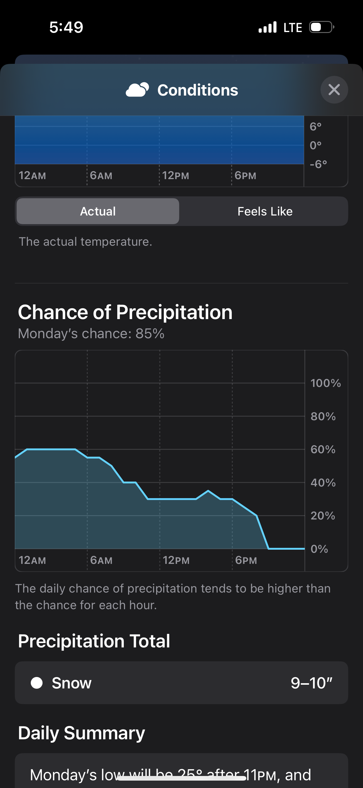
This is what my I phone says. Not including 2-4 from the day before… lock it in.

-
I’m so team UKIE I just got the ingredients for my milk sammiches.
-
Meanwhile in the Mid Atlantic

-
By this evening when all the models have a good sampling of data I’d say things will be more inline. Which way things go is up in the air. Just pour a drink or spark a bowl.
-
I think I’m the only one riding with the Ukie. Lolol
-
I’m enjoying the little extra bit we seem to get on the wrap around up here in the hills… I’m just glad we have something to track and watch. Happy winter yall. Also we get some snow on the ground it’s like my pawpaw always said, snow beckons more snow.
-
I agree about the NAM. I’m tossing it out this AM. lol
-
It’s hard to tell, it looks like they damn near copy and pasted the Euro. Channel 10 is lower than them and the NWS has us around 1-2 inches with ice. Who knows. We are in a weird spot. My gut is telling me that cold air will stay a little more stout against the blue-ridge, and north of 460 will stay snow longer and over perform. Just feels like the CAD in our area is always underestimated on the models.
-
I personally love the euro/ol Uncle Ukie lol.
-
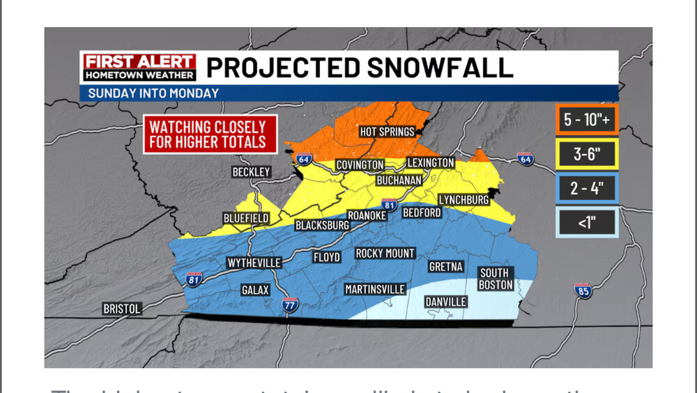
Local stations predictions this AM in my area. Calling for quite a bit more than the NWS. As well as about a 10th to a quarter inch of ice.
-
I’m hoping the same. It must be a tough forecast for our local Mets. I’m thinking we will do fairly well I have a good feeling this will overperform for us. The CAD west of the blueridge is always underestimated.
-
Our area really is all over on this one. I’ll also be curious to see how the CAD helps us. I’m up in Eagle Rock so I’m thinking we will see more snow than is being shown on the GFS
-
How is it looking for areas north west of Roanoke close to the WV boarder? Been riding that snow mix line.
-
Sorry about that, I forget about the banter page a lot.
-
South/Central VA crew watching/hoping the south trend continues for sun/mon

-
The latest from Blacksburg, hopefully they update frequently. LONG TERM /SUNDAY THROUGH WEDNESDAY/... As of 200 AM EST Thursday... Key Messages: 1) Confidence is increasing for a wintry mix of precipitation lingering into Monday. 2) Arctic air will push temperatures further below normal during Tuesday and Wednesday. Monday could feature a plethora of precipitation types due to a Miller B system tracking eastward across the Appalachian Mountains. While the parent low dissipates in the mountains, a second area of low pressure should develop across eastern North Carolina and head offshore. A wintry mix will continue through Monday until a dry slot can squeeze its way northeastward along the Blue Ridge as the system departs. Although details still remain murky, the overall consensus depicts rain spreading northward in parts of North Carolina and Virginia where temperatures try to rise above freezing. However, this milder air will have to fight against colder air near the surface that will keep a mix of freezing rain and sleet in play.
-
I personally am hoping the warm nose isn’t much an issue here in SW VA. It’ll be interesting to see where the snow mix line ends up. I’m thinking just south of I64. Just depends how the CAD sets up. I’m also hoping it trends a little further south. I hate dealing with Ptype issues.