Stormchaserchuck1
-
Posts
3,294 -
Joined
-
Last visited
Content Type
Profiles
Blogs
Forums
American Weather
Media Demo
Store
Gallery
Everything posted by Stormchaserchuck1
-
It was looking hopeful last Winter and Spring that we were turning to more +PNA, now it seems like -PNA is coming back...
-

El Nino 2023-2024
Stormchaserchuck1 replied to George001's topic in Weather Forecasting and Discussion
SSTs are somewhat secondary to atmospheric conditions, and the El Nino has not yet taken control, getting out of the Weak-Moderate impacts/effects limbo range. -
It's hard to imagine the -2.5 PDO will overpower with stronger El Nino conditions now developing in the subsurface. If the subsurface continues to warm to 7c and holding, we should have constant variations of +PNA. Less than 7c subsurface and I say we are still in "Weak Nino" impacts.
-
El Nino 2023-2024
Stormchaserchuck1 replied to George001's topic in Weather Forecasting and Discussion
Should be an interesting Winter. Aleutian low's and high's have been going back and forth, but this is a pretty good +PNA signal in the extended http://www.meteo.psu.edu/ewall/ENSHGTAVGNH_12z/ensloopmref.html -
El Nino 2023-2024
Stormchaserchuck1 replied to George001's topic in Weather Forecasting and Discussion
Subsurface is warming actually pretty rapidly right now https://ibb.co/1nrDtgp -
I agree with Terpeast's assessment that we are >25-30% likely to see a blizzard this winter or "major snowstorm (>18")" (minus wind). STJ is really juicy starting last December. If we can get that GOA low or +PNA to sit for 10-15 days, it's bomb's away. I don't see the Fall pattern breaking this wetter than average tendency in the pattern. The only problem I see is N. Pacific low's could be transitory.
-
The last El NIno with -QBO before that was 09-10. Then 91-92, 86-87.
-
I think we are in a "SE High pressure tendency for amplification"-state so a -PNA would really not be good for any snow right now. +PNA or -EPO is almost definitely needed for snow chances, so it is a good thing we are in an El Nino right now (The Atlantic has proven not able to overcome bad Pacific conditions since about 2013- (Pacific is about 4x greater correlation for cold than the Atlantic in that time so legit El Nino here is what's needed)). Both the High's and the low's are amplifying.
-
Yeah, it's because of -PNA conditions. We don't want -PNA in the Winter. It's weird that it would correlate with a SE trough in the beginning anyway.
-
The pattern is definitely wet. I can envision a GOA low or +PNA coinciding with developing coastal/SE low's. I saw that trend last Winter, and it has continued until now, and going forward. -PNA's I think would be drier in the Wintertime.
-
El Nino 2023-2024
Stormchaserchuck1 replied to George001's topic in Weather Forecasting and Discussion
LR +PNA came in stronger today, 3 contours. https://ibb.co/9pDwnWQ In October, I start looking to see if ENSO is impacting the cooler season wavelengths. In this case, it's yes, but I still think that the ENSO is acting like a Weak event. -
El Nino 2023-2024
Stormchaserchuck1 replied to George001's topic in Weather Forecasting and Discussion
We now have a west-based +PNA projected to show up for early October, which is more El Nino-like. https://ibb.co/k9rmC0s -
-QBO increases 10mb warming, as does El Nino, so together they are a good 10mb warming signal. These Stratosphere warmings often downwell to -AO.
-
El Nino 2023-2024
Stormchaserchuck1 replied to George001's topic in Weather Forecasting and Discussion
Not looking like we are breaking +1.6 Strong Nino ground in the North Pacific right now for sure. It's acting like a Weak El Nino, if anything at all. MEI is probably the closest measurement to what's happening in the 500mb pattern. -
Going to get a yucky PDO number after the N. Pacific pattern in September. We are not doing better than splitting -PNA's and +PNA's right now. With Nino 1+2 possibly peaking, it's not like a stronger wave of El Nino is on the way, possibly.. That may depress some of the +PNA potential for the Winter, giving us something like neutral or mixed. It's still early though, I just think this pattern needs to change and it's not, and we may need a stronger variable like a re-up of El Nino. MEI at +0.3 or something is a good reflection.
-
El Nino 2023-2024
Stormchaserchuck1 replied to George001's topic in Weather Forecasting and Discussion
This is a strong -PNA for the next 15 days.. since the El Nino developed in May, we have an even split of +PNA's and -PNA's. -
Category Five Hurricane Lee
Stormchaserchuck1 replied to WxWatcher007's topic in Tropical Headquarters
The 00z NAM at 84hrs is considerably south of the 18z GFS at 90hrs. That's a strong trough moving into the NE though. Animation: https://ibb.co/rcBwKjD -
Strong El Nino and Strong -QBO is about a 1/25 year type happening. Obviously, there is a chance that it doesn't connect perfectly, but it should be interesting https://www.cpc.ncep.noaa.gov/data/indices/qbo.u30.index
-
Winter 2023-2024
Stormchaserchuck1 replied to Stormchaserchuck1's topic in Weather Forecasting and Discussion
Heading for a deeply negative QBO Winter. -
The thing is already Cat 4. ^That model doesn't show it hitting Cat 4 for another 60 hours. We do ultimately have a +PNA trough sticking in, but it's still pretty far south at 17N, and until it reaches 20N, that's when climo takes it away. 20N/60W is a huge point for it to pass NE or SW from for hits, a NE pass goes out to sea 90% of the time.
-
2023 Mid-Atlantic Severe Wx Thread (General Discussion)
Stormchaserchuck1 replied to Kmlwx's topic in Mid Atlantic

- 2,785 replies
-
- 7
-

-
- severe
- thunderstorms
- (and 3 more)
-
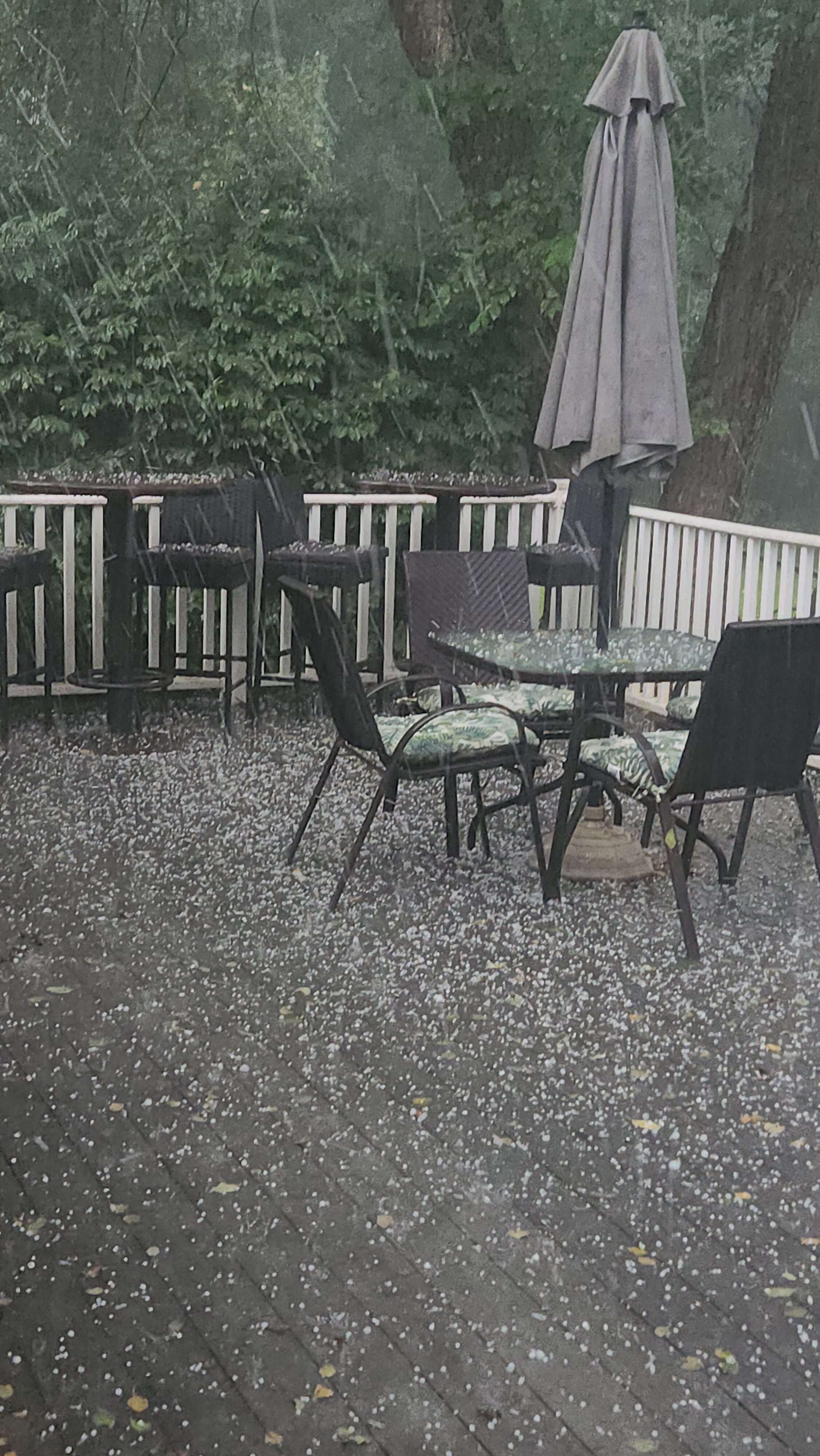
2023 Mid-Atlantic Severe Wx Thread (General Discussion)
Stormchaserchuck1 replied to Kmlwx's topic in Mid Atlantic
I had 15 minutes of straight hail. Minute 15 we got to 1-1/2". https://ibb.co/hF1Qfb2 https://ibb.co/YQQKfgk- 2,785 replies
-
- 4
-
-
- severe
- thunderstorms
- (and 3 more)
-
2023 Mid-Atlantic Severe Wx Thread (General Discussion)
Stormchaserchuck1 replied to Kmlwx's topic in Mid Atlantic
This low pressure looks amped for severe wx chances tomorrow- 2,785 replies
-
- 1
-
-
- severe
- thunderstorms
- (and 3 more)
-
Category Five Hurricane Lee
Stormchaserchuck1 replied to WxWatcher007's topic in Tropical Headquarters
60W/20N is a significant landmark. Storms that pass NE of it go out to sea 90% of the time, storms that pass SW are more likely to hit land, at I think 60/40, all storms included. -
El Nino 2023-2024
Stormchaserchuck1 replied to George001's topic in Weather Forecasting and Discussion
I think that is probably true, like we've seen all Summer. On the other hand, -PNA's aren't sticking either.