Stormchaserchuck1
-
Posts
3,294 -
Joined
-
Last visited
Content Type
Profiles
Blogs
Forums
American Weather
Media Demo
Store
Gallery
Everything posted by Stormchaserchuck1
-
Fwiw, Natural Gas is trading at 2.9, down from 3.6, which implies a +NAO Winter. Greenland 500mb correlates at +80dm DJF with NG. https://ibb.co/c6X7MyN
- 1,295 replies
-
- 4
-

-

-

-
- wishcasting
- almost winter
- (and 1 more)
-
Im about to cancel 24-25 Winter.. we likely will have a +QBO to go along with Nina (same as last Winter)
-
12z GFS gives us some flakes early next week
- 1,295 replies
-
- 2
-

-
- wishcasting
- almost winter
- (and 1 more)
-
Pacific changes from unfavorable to favorable for cold 11/20 AO goes negative 11/24 Models try to give NAO negative as a 3rd wave 11/30, but I'd watch for fluctuations, as the last few weeks has had a lot of NAO changes at that range. Then there is signal for wave dropping into the SW 12/1-2, possibly timing with -NAO lifting out around 12/3-5, but that's far away..
- 1,295 replies
-
- 12
-
-
- wishcasting
- almost winter
- (and 1 more)
-
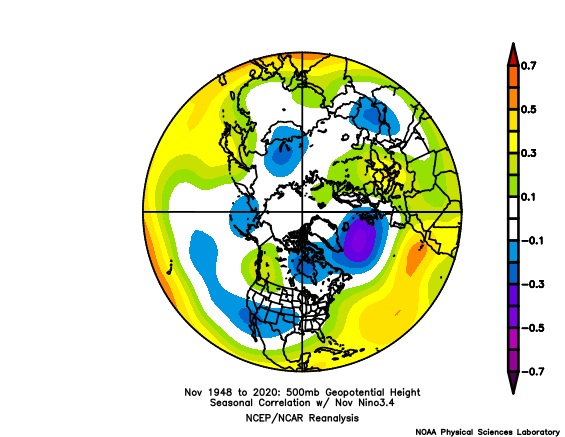
Historically, when strong Nino's don't act like Nino's and produce -PNA's we get strong -NAO patterns in the Wintertime, but let's see what happens. Nov correlation to El Nino and N. Pacific pattern is less than 0.1, since 1948.
-
Usually -EPO's verify a little bit cooler anyway.. The Pacific high is a bit south of the classic -EPO position, but the models have been in heavy run-to-run flux and we are in an El Nino..
-
The +PNA is not ending up over the NPH (North Pacific High) position at all so far.. that (+NPH) is usually what happens in east-based Nino events.
-
It seems like everytime we are dry since 2002, we get very wet periods soon thereafter. I said back in the Summer I wanted a dry Fall..
-
Nothing Nino about this.. strong -PNA it looks like for the month of November https://ibb.co/3dppvDs https://ibb.co/YPPdM43 Like I said before, slight correlation to February, but not December.
-

9th Annual Mid-Atlantic Snowfall Contest
Stormchaserchuck1 replied to RodneyS's topic in Mid Atlantic
BWI: 48” DCA: 37” IAD: 50” RIC: 26” Tiebreaker SBY: 34”- 179 replies
-
- 11
-
-
-
El Nino 2023-2024
Stormchaserchuck1 replied to George001's topic in Weather Forecasting and Discussion
Good post. It's lazy to think that an El Nino produces a -PNA December because a few examples show that. The natural state is +PNA. -
Winter 2023-2024
Stormchaserchuck1 replied to Stormchaserchuck1's topic in Weather Forecasting and Discussion
In 2005, I made timeseries of all indexes, and found a strong correlation with N. Atlantic SSTs May-Sept, as a lead predictor to the following Winter's NAO. I don't have the custom index anymore, but you can somewhat see it here: https://ibb.co/M9W0Q63 In the next 17 years, I tested it real time, and found it 13-4 in getting the raw NAO state correct, and in the beginning I estimated a 0.54 SD ("0" is 50% chance of -0.54 to +0.54), and that verifies 9-8, since 2005. Here is this the boxes I calculate, although the most accurate way goes from May-Sept (not May-Aug): https://ibb.co/Y8bTrWL This years SST index comes out at -0.05, so a 50% chance of the DJFM NAO being -0.59 to +0.49 [CPC]. So my supposingly successful method is predicting a "Neutral NAO" for Winter 23-24. Here is this year's raw map and plot: https://ibb.co/ZmQyz8k https://ibb.co/Hx1Mjcs -
No -NAO today lol https://ibb.co/4mqVZzZ
-
18z GFS is now developing a -NAO in the MR/LR where it used to have +NAO. Way Above average model run changes since the Spring.
- 1,295 replies
-
- 1
-
-
- wishcasting
- almost winter
- (and 1 more)
-
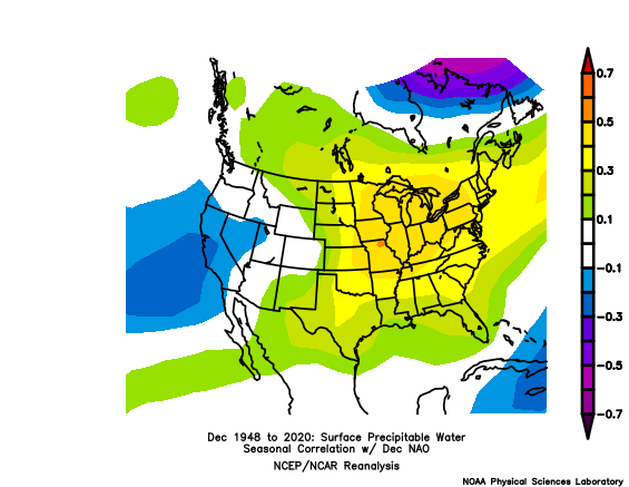
The NAO actually has a high correlation to precip. 0.4 in December, and near 0.5 for the Winter as a whole. This is why it was so disappointing that last years -NAO didn't deliver: It happened with a wetter than average pattern. I found that there were 2/11 -NAO December's that had a wet pattern (one being last year). I would take a favorable Pacific/+NAO for snow chances 20-30% greater than even.. (of course, you know that when -NAO lifts out we usually get a storm.)
- 1,295 replies
-
- 5
-
-
- wishcasting
- almost winter
- (and 1 more)
-
I think as long as the central-ENSO subsurface stays warm it will be hard for a -PNA to sustain. It's still warming despite the neutral MEI
-
These runs are really fluctuating from one to another. Even the ensembles. A few days ago they had a strong LR -PNA, now it's gone.
-
People don't understand weather. Why aren't Strong La Nina's cold, if Strong El Nino's are warm? Strong El Nino's are more realistically the blend of the historical analogs of Weak-Moderate-Strong past events put together. Weak El Nino's are more random, or neutral, the cold signal is just a lack of many examples, as it is though somewhat showing the base-Nino state (Weak-Moderate-Strong).
-
Opposite correlation, in science you get correlations from 0.00 to 1.00, if you use the negative side you get 2x result. Use anomalies, it mostly works, probably greater than 90% correlated (+ and - side).
-
The last 4 +QBO/La Nina's have been historically bad so I'm hopeful I think the trend of the last 7 years is still strong though, for example: I don't expect 02-03 where it was snowing every day, the Winters surrounding that were more alike.
-
I'd kinda worry about the February -PNA trend of the last 6 years, which gives us a +150dm anomaly. NAO might be negative at that time given all the Stratospheric warming signals, but Feb I think is not a blow out in the Pacific.
-
El Nino 2023-2024
Stormchaserchuck1 replied to George001's topic in Weather Forecasting and Discussion
Why are El Nino's warm in December? What is the physical reason? Why aren't La Nina's cold? Cold Winter's start cold in December, it's the intro month to longer wavelengths season.. the Winter sets in in December at like a 0.30-40 correlation, if you base it on a 200yr period. Really, Oct and Nov should start cold too. -
Oct QBO came in at -16.98, and still dropping. Having a Strong El Nino/Strong -QBO is rare... probably 1/25 year type event, for this type of strength of both. In the next few days, I might do some research and post maps about the unusually high 10mb correlation in the Winter.
-
The default is +, so +NAO has negative heights over Greenland. Fwiw, -PNA Nov has 0.2 correlation with -NAO December.
- 1,295 replies
-
- 2
-
-
- wishcasting
- almost winter
- (and 1 more)
-
El Nino 2023-2024
Stormchaserchuck1 replied to George001's topic in Weather Forecasting and Discussion
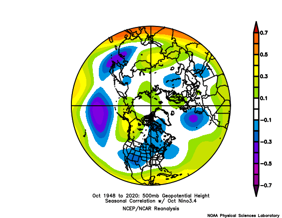
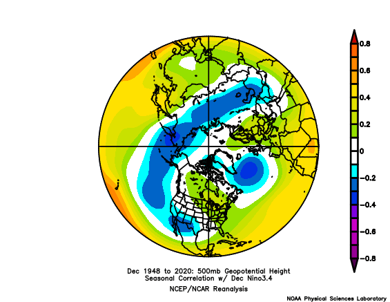
Nov doesn't historically have a high correlation to the PNA This is after Oct had a decent +pna/-epo correlation that I think we hit. In December the strong N. Pacific influence of ENSO for the Winter starts to present itself