-
Posts
3,293 -
Joined
-
Last visited
Content Type
Profiles
Blogs
Forums
American Weather
Media Demo
Store
Gallery
Everything posted by Stormchaserchuck1
-

El Nino 2023-2024
Stormchaserchuck1 replied to George001's topic in Weather Forecasting and Discussion
Yeah.. you're right [default positive] Counter intuitive to what you would expect in El Nino I guess the relative difference is a strong indicator. -

El Nino 2023-2024
Stormchaserchuck1 replied to George001's topic in Weather Forecasting and Discussion
I don't know.. east-based, west-based doesn't really account for the -PNA pattern we have seen so far. East-based most impacts the NPH (North Pacific High) https://ibb.co/bR7r8Fv and we haven't really seen any signs of that so far. I think even going into February, a +PNA would be more likely than a GOA low (-NPH pattern). It just hasn't really been building. -
No shortage of precipitable water right now in the N. Hemisphere https://ibb.co/L6PLQdc https://ibb.co/WpVDLKn
-
Thanks. Globe has been really wet the last 4 months too. https://ibb.co/WpVDLKn
-
Looks like it's about 0.3 https://ibb.co/P4sqQf5 (barely above 0.0 in March)
-
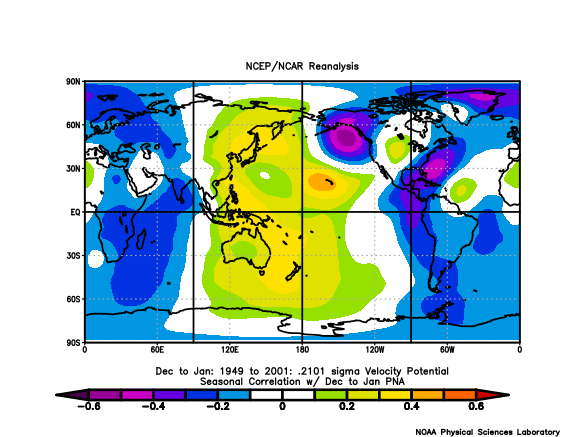
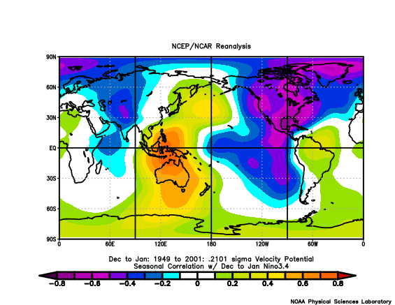
-PNA has a strong correlation to precip. >0.5 in January https://ibb.co/ZhPJnV9 -PNA in El Nino, especially Strong El Nino.. really wet combo there
-
Jaleen Hurts had won 25/26 for a while there.. It was making me a little mad because I didn't think they did anything special, although you see how having a scrambling QB really ups the odds.
-

Jan Medium/Long Range Disco: Winter is coming
Stormchaserchuck1 replied to stormtracker's topic in Mid Atlantic
model error/biases are worth pointing out -

Jan Medium/Long Range Disco: Winter is coming
Stormchaserchuck1 replied to stormtracker's topic in Mid Atlantic
Watching SE Canada pressure https://ibb.co/tC5bQQN -

Jan Medium/Long Range Disco: Winter is coming
Stormchaserchuck1 replied to stormtracker's topic in Mid Atlantic
Block over the Aleutian islands now. A few days ago, it was Alaska. Hard not to get a little SE ridge with that in January. But there is a ridge in the WC, so maybe it can dampen the wave. -

Jan Medium/Long Range Disco: Winter is coming
Stormchaserchuck1 replied to stormtracker's topic in Mid Atlantic
I think you're separating the Pacific and Atlantic automatically, when since 2013 they have posted a 0.30 correlation, and since 2019 a ~0.40 correlation. It may even be a greater correlation this year! I'm not saying we want a +NAO.. no way Jose that's a warmer pattern at 0.4, but if they are correlating with Pac +PNA greater than 0.40 than it's something to look for! If I could still post custom ftp files on the CDC site, I would show you an example of the last 200-300 days with -NAO/+NAO.. -nao's have a -pna/+epo, and +nao's (although less of a correlation) have weak +pna/-epo. That's all. Just pointing out a trend. (Does anyone know how to still run custom files on CDC ftp site? I used that for so much good stuff in the early 2010s (Stratosphere warming plots, time lag, etc), but they seemed to have discontinued the option to compile a list of, for example 300 custom days, as far as I know. -

Jan Medium/Long Range Disco: Winter is coming
Stormchaserchuck1 replied to stormtracker's topic in Mid Atlantic
I think the two snowy Winters of 13-14 and 14-15 both had big +NAO's. I just say let's see if it can sync up with +PNA, if it can, like 14-15 (which was an El Nino), maybe it will be a snowy pattern. We've been having a ridge hook up with Greenland/Davis Strait ridging, so maybe we can likewise extend a trough south from Greenland too? That's my guess. It's an unmistakable pattern right now. I have to worry about Feb PNA though, because in the last 6 years we've had a mean of +150dm, which is even a few std's above enso. What a test for El Nino conditions coming up in the N. Pacific! -

Jan Medium/Long Range Disco: Winter is coming
Stormchaserchuck1 replied to stormtracker's topic in Mid Atlantic
I get what you're saying.. The Euro also trended colder at hr120. See how it's 75% more cold over the US, just holding that other 25% with more cutting from the storm system (timing). Usually +heights over or just north of Alaska is a cold trend, but not everything's perfect. -

Jan Medium/Long Range Disco: Winter is coming
Stormchaserchuck1 replied to stormtracker's topic in Mid Atlantic
I think the overall ridge is oriented a little too far south to really be a cold pattern. See how it's over the Bering Sea https://ibb.co/Fz2njZ0 That's -PNA territory https://ibb.co/nDVv5jq -

Jan Medium/Long Range Disco: Winter is coming
Stormchaserchuck1 replied to stormtracker's topic in Mid Atlantic
Day 10 Euro has a 552dm block over the Davis Strait and the storm still cuts up and is rain.. as is the pattern, The Aleutians islands having a big ridge/block is overwhelming -NAO almost all the time since 18-19. -

Jan Medium/Long Range Disco: Winter is coming
Stormchaserchuck1 replied to stormtracker's topic in Mid Atlantic
I think the problem is that ridging extends down south into the PNA area. I've been studying EPO vs PNA, and they both happen a little further north in latitude than what you would expect. EPO is a little north of Alaska, and usually has a weak trough under it: https://ibb.co/tc1329x https://ibb.co/ZHHbxNm Having more heights over Alaska is a good step, but it's still a fairly weak pattern, and the N. Pacific high is a little more firm too. I like the 16/17 of all the potential going forward.. I've found when the NAO is deeply negative then rises sharply to zero, it's hard for us to go that time period without at least seeing some snow (although it could be a dusting - 1"). I don't get the big deal about the pattern after that, PNA looks like it might go positive, but I've said before that, that should happen if/as the NAO goes +. -
It seems like the +AMO is peaking still. The CPC last updated their timeseries in Jan 2023. From 1 year ago: September 2022 AMO was +0.662, the highest on record for September since 1948 (2nd was +0.435) October 2022 AMO was +0.483, the highest on record for October since 1948 https://psl.noaa.gov/data/correlation/amon.us.data Jan ends the data. Then we had this in 2023: https://ibb.co/4djpgtR I would say it's near peaking, or 2022-23 was the peak. That gives it at least 10 more years imo of +AMO cycle. (Sept '22 +0.662 was the highest in that whole timeseries, with no other month-years exceeding +0.505, although if you count negatives, the 2nd highest is -0.536.)
-
Can you believe Vegas has SF 2x more likely to win the Super Bowl than the Ravens? https://sportsbook.fanduel.com/navigation/nfl?tab=super-bowl (It was +380 earlier. I guess they like when Lamar doesn't get hurt) Still.. Ravens have a better record. We have 5 straight wins over teams 3+ games over .500 by 14+ points! (NFL record). We are 16-0 prior to this game with 2:00 left in the 4th quarter. We have a better record than SF, and we won there on the road by 2 TD's! Crazy. Lamar is 41-10 as a starter. Ravens had 1/21 odds preseason, and SF was about 1/5, so maybe this is just a hangover from that?
-

El Nino 2023-2024
Stormchaserchuck1 replied to George001's topic in Weather Forecasting and Discussion
NYC hit 60 in December with an AO near -3 too. I think it's oppositely correlating with the Pacific right now. We'll see -

Jan Medium/Long Range Disco: Winter is coming
Stormchaserchuck1 replied to stormtracker's topic in Mid Atlantic
The -NAO is rushing out in a hurry. That's going to give it 10 days! The December one was 10 days too. If you look back over the last several Winters they have not had much staying power. Since we have an ongoing Stratosphere warming through mid-month, it's especially not happening because these usually correlate with 500mb ridging +time. The GEFS wants to quickly turn the NAO positive post 1-20. I'm honestly willing to take a chance, I feel the Pacific could be more favorable if we have +nao conditions develop. Before then, Pacific ridge is still kind of south to favor a snowstorm, then the NAO lifts out, although when it's rapidly rising to Neutral (Jan 16-17) we are more likely to see snow. -
We have been having a minor Stratosphere warming for the last 12 days. https://ibb.co/2YgZXJm
-

Jan Medium/Long Range Disco: Winter is coming
Stormchaserchuck1 replied to stormtracker's topic in Mid Atlantic
I love snow, snow on the ground, drifts, wind. -

Jan Medium/Long Range Disco: Winter is coming
Stormchaserchuck1 replied to stormtracker's topic in Mid Atlantic
I'm glad I was in Florida for Jan '16. I was sitting there going muahaha -

Jan Medium/Long Range Disco: Winter is coming
Stormchaserchuck1 replied to stormtracker's topic in Mid Atlantic
KU patterns have a trough in the Gulf of Alaska, or the NE N. Pacific (and not '91-20 averages either), stronger. -

Jan Medium/Long Range Disco: Winter is coming
Stormchaserchuck1 replied to stormtracker's topic in Mid Atlantic
I think it's because it's extended south to Gulf of Alaska or Aleutian island ridging too. -EPO in January by itself is a highly correlated cold pattern: https://ibb.co/tc1329x https://ibb.co/ZHHbxNm -NAO's are usually drier. They have a 0.45 correlation to less precip all else neutral, that's why it's special that the models are showing such a juicy storm at the peak of -NAO. Hopefully the Pacific can get worked out, so that we don't waste it.


