

Stormchaserchuck1
-
Posts
3,291 -
Joined
-
Last visited
Content Type
Profiles
Blogs
Forums
American Weather
Media Demo
Store
Gallery
Everything posted by Stormchaserchuck1
-

Jan Medium/Long Range Disco 2: Total Obliteration is Coming
Stormchaserchuck1 replied to Jebman's topic in Mid Atlantic
Yeah it makes the later part of the wave the one to watch, which would time with the -NAO rising better. -
Jan Medium/Long Range Disco 2: Total Obliteration is Coming
Stormchaserchuck1 replied to Jebman's topic in Mid Atlantic
18z NAM is a little flatter vs 12z GFS fwiw https://ibb.co/ftdFKW1 Hudson Bay low is moving all around.. it would be nice to get that to phase https://ibb.co/gjBvWfw -
Jan Medium/Long Range Disco 2: Total Obliteration is Coming
Stormchaserchuck1 replied to Jebman's topic in Mid Atlantic
Aleutian island block may help this thing trend NW in the coming days.. It's not like we are in some deep +pna pattern, the pacific is still favorable for a slight SE ridge.. maybe this works to our favor this time. Either way, the Euro and GFS ensembles in agreement is usually a good combo -
Jan Medium/Long Range Disco 2: Total Obliteration is Coming
Stormchaserchuck1 replied to Jebman's topic in Mid Atlantic
Yeah, we had a nice NE Pacific High pressure when the 2-3 cutters happened though https://ibb.co/GFXBnJG Now, the NAO space and 50/50 low were just about perfect, but this goes back to our argument that the Pacific is dominating right now.. -
Jan Medium/Long Range Disco 2: Total Obliteration is Coming
Stormchaserchuck1 replied to Jebman's topic in Mid Atlantic
Yeah like something over the Gulf of Alaska. Correlation works less after Jan, into Feb-Mar though. +0.53 in Jan, +0.3 in Feb, +0.2 in March <(closer we can get to GOA low with a mean trough over the east). -
Jan Medium/Long Range Disco 2: Total Obliteration is Coming
Stormchaserchuck1 replied to Jebman's topic in Mid Atlantic
2016 is best analog, but Fall/Winter 2023-24 is #1 right now for global precipitable water since 1948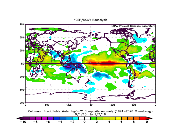
-
Jan Medium/Long Range Disco 2: Total Obliteration is Coming
Stormchaserchuck1 replied to Jebman's topic in Mid Atlantic
LR GFS has a nice -EPO.. that's what I want to see.. and +PNA. Let's get this thing going.. Whole world and the subtropics are really wet right now. -
Jan Medium/Long Range Disco 2: Total Obliteration is Coming
Stormchaserchuck1 replied to Jebman's topic in Mid Atlantic
18z GEFS really doesn't have much with the 16-17 storm. 3/27 members it looks like. -
Jan Medium/Long Range Disco 2: Total Obliteration is Coming
Stormchaserchuck1 replied to Jebman's topic in Mid Atlantic
Following February's from those analogs look like seasonal models currently have https://ibb.co/K6mtPwr Globe is a little too cold biased for my liking, and the GOA low has been missing so far in this El Nino. Maybe D+8 model will shift a little bit. -
Jan Medium/Long Range Disco 2: Total Obliteration is Coming
Stormchaserchuck1 replied to Jebman's topic in Mid Atlantic
Yeah, if that block can hold over Alaska, and close off a strong low underneath of it, downstream wave should be able to pick up energy from the gulf.. we're almost there. Still a little ways to go -
Jan Medium/Long Range Disco 2: Total Obliteration is Coming
Stormchaserchuck1 replied to Jebman's topic in Mid Atlantic
CPC is going with below average precip right now https://ibb.co/Zg7hQs7 -
Jan Medium/Long Range Disco 2: Total Obliteration is Coming
Stormchaserchuck1 replied to Jebman's topic in Mid Atlantic
I am interested to see if +PNA holds if we go back to -NAO past 15D.. -
Jan Medium/Long Range Disco 2: Total Obliteration is Coming
Stormchaserchuck1 replied to Jebman's topic in Mid Atlantic
Stratosphere warming should hit be hitting a favorable -NAO correlation time around then, too. It's like +80-120dm on the mean at +20-25 days. -
Jan Medium/Long Range Disco 2: Total Obliteration is Coming
Stormchaserchuck1 replied to Jebman's topic in Mid Atlantic
Initial trough is further SW on 18z NAM 84hr vs 12z GFS 90hr https://ibb.co/6bV088Y -
Jan Medium/Long Range Disco 2: Total Obliteration is Coming
Stormchaserchuck1 replied to Jebman's topic in Mid Atlantic
I guess we are chipping away at the PDO. I was never a believer in PDO being a leading indicator, but this Winter sure has made a case. I think we are up to -0.6 and still having a tendency to rise, so maybe a more organized +PNA can get going here in the next few weeks. It's also amazing how these El Nino constants hold (warm Dec, good 2nd half of Winter). Let's see if the +PNA can hold through February, because we are coming off the most powerful 6-year constant on record (-PNA) for February ('18-23) -
Jan Medium/Long Range Disco 2: Total Obliteration is Coming
Stormchaserchuck1 replied to Jebman's topic in Mid Atlantic
00z NAM much different than 18z GFS at 84hr https://ibb.co/C1W8QQQ -
Jan Medium/Long Range Disco 2: Total Obliteration is Coming
Stormchaserchuck1 replied to Jebman's topic in Mid Atlantic
I would have told you it's wet.. It's Global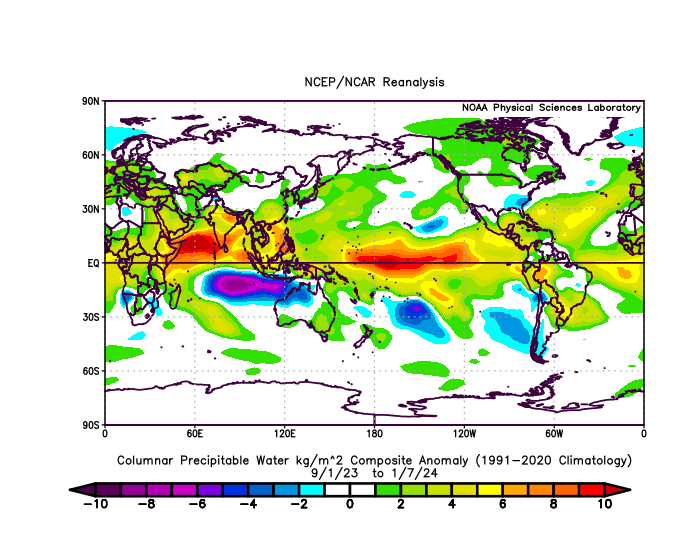
-
Jan Medium/Long Range Disco 2: Total Obliteration is Coming
Stormchaserchuck1 replied to Jebman's topic in Mid Atlantic
I like the long range.. ridge builds off the west coast, PNA goes positive.. this positive PNA evolution is fitting exactly the 15 analogs I came up with that had a -PNA Jan 5-13, during an El Nino or Neutral ENSO. I thought it was telling, because in roll forwards you usually see the same variable smoothed out, but it gave me a reversal to -100-120dm Aleutian low and 80dm -epo by Jan 25th. Now look at what's happening when all this positive change is happening on the model... The NAO is +. And it looks like a 2std positive event with -200dm on the D14-15 ensemble mean. I was telling PSUhoffman that, that is what we need right now to flip to a favorable pattern in the Pacific and probably on the west coast.. let's hope these probabilities hold as we go into the last week of January. -
Jan Medium/Long Range Disco: Winter is coming
Stormchaserchuck1 replied to stormtracker's topic in Mid Atlantic
Problem is that 970s/980s mb low in SE Canada. Not going to cool down enough if that happens. -
Jan Medium/Long Range Disco: Winter is coming
Stormchaserchuck1 replied to stormtracker's topic in Mid Atlantic
Yeah, 970s mb low in the Hudson Bay with no High around it could make for a warmer pattern even if the track is good -
El Nino 2023-2024
Stormchaserchuck1 replied to George001's topic in Weather Forecasting and Discussion
In September 2022, the AMO shattered records hitting +0.662 for the month. 2nd place was -0.536 in 1974 and +0.505 was the 2nd highest monthly positive reading. +15 months you see a good +WPO signal for December 2023: https://ibb.co/WKN16kw Which is also kind of a now-time +AMO indicator https://ibb.co/0qpS3t4 Feb posts a SE ridge, which is something I'm watching out for this year, as the mean of the last 6 February's in the PNA region has been +150dm (record). It will be interesting to see if that or the El Nino wins out this year. https://ibb.co/hs8h0T5 -
El Nino 2023-2024
Stormchaserchuck1 replied to George001's topic in Weather Forecasting and Discussion
The PNA has a really strong correlation to warmth in the east in January.. >0.5 https://ibb.co/rZ5HkST We just haven't been timing it right.. we got +pna in December when the correlation was 0.1, then on Jan 1-2 the pattern changed. -
El Nino 2023-2024
Stormchaserchuck1 replied to George001's topic in Weather Forecasting and Discussion
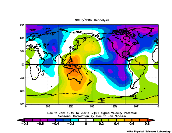
I mean.. that's some pretty incredible stuff. +VP at the dateline is +PNA, but El Nino is associated with -VP at the dateline.. We all know the strong ENSO/N. Pacific correlation.. -
El Nino 2023-2024
Stormchaserchuck1 replied to George001's topic in Weather Forecasting and Discussion
Yeah.. you're right [default positive] Counter intuitive to what you would expect in El Nino I guess the relative difference is a strong indicator.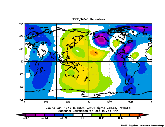
-
El Nino 2023-2024
Stormchaserchuck1 replied to George001's topic in Weather Forecasting and Discussion
I don't know.. east-based, west-based doesn't really account for the -PNA pattern we have seen so far. East-based most impacts the NPH (North Pacific High) https://ibb.co/bR7r8Fv and we haven't really seen any signs of that so far. I think even going into February, a +PNA would be more likely than a GOA low (-NPH pattern). It just hasn't really been building.


