Stormchaserchuck1
-
Posts
3,291 -
Joined
-
Last visited
Content Type
Profiles
Blogs
Forums
American Weather
Media Demo
Store
Gallery
Everything posted by Stormchaserchuck1
-
I measured 3.5".
-

Jan/Early Feb Medium/Long Range Discussion Part 3
Stormchaserchuck1 replied to WinterWxLuvr's topic in Mid Atlantic
According to the CPC, it's been a Strong +NAO Winter. I don't really get that because look at Greenland, and even a little cold pocket over the Azores https://ibb.co/WW5kVPZ Yet December came in at +1.94, and January according to their predictions forward should come in around ~+1.00. Pretty huge discrepancy there https://www.cpc.ncep.noaa.gov/products/precip/CWlink/pna/norm.nao.monthly.b5001.current.ascii.table -
Jan/Early Feb Medium/Long Range Discussion Part 3
Stormchaserchuck1 replied to WinterWxLuvr's topic in Mid Atlantic
Have you found that Mountain Torque actually does that though? I once calculated all the +EAMT events and found no strong correlation to the current and future pattern. Pressure over the Himalaya's was easy to read/record too, on the satellite data going back to 1948. They said that it correlates to 10mb warming, but I even got a weak signal there too. -
Jan/Early Feb Medium/Long Range Discussion Part 3
Stormchaserchuck1 replied to WinterWxLuvr's topic in Mid Atlantic
Unbelievable that that's even on the table with +NAO as strong as it is. I haven't been saying to PSU that the NAO should be positive for us to see snow, I've said that the Pacific correlating, and in many cases more than evening it out (on both sides of the index), is interesting, and could result in better winter patterns going forward in this state since the NAO has almost as strong of a precip correlation as a temperature correlation here on the EC. (I'm not predicting snow or ice with the 25th storm). -
We should get 3-4".. Hrr looks pretty impressive, still snowing at 4pm. Interesting to see if they do better than the global models here in the short range.
-
Another 3" Hrr run for northern MD. It went a little north around DC vs 02z.
-
Global models still behind short range models for snow totals.. GFS has 1-2", and the NAM was near the same, but Hrr and RAP have been impressive many runs in a row.. 3-4". The Global models hold back is why I think NWS isn't issuing WSW's.
-
Jan/Early Feb Medium/Long Range Discussion Part 3
Stormchaserchuck1 replied to WinterWxLuvr's topic in Mid Atlantic
That's a +3SD +NAO on the 18z GEFS hr 168. It connects with the lower part of the measurement in Europe and the US, too. Just impressive.. we haven't had much of that strength since 1997 (0 +analogs for the exact dates, Jan 22-28, since 1997). -
Jan/Early Feb Medium/Long Range Discussion Part 3
Stormchaserchuck1 replied to WinterWxLuvr's topic in Mid Atlantic
I don't know.. this mid-Winter is doing a pretty good job with cold. I think we just really that much underestimate the PNA.. When it's positive, cold air seems to be no problem. -
El Nino 2023-2024
Stormchaserchuck1 replied to George001's topic in Weather Forecasting and Discussion
Cold water is starting to breach the central-subsurface region https://ibb.co/VBXkpzz Believe it or not, but this central region correlates most to PNA, so if we start seeing below average there it could favor more -PNA conditions going forward. Interesting because the surface is still in Strong-Nino territory, subsurface index is about -0.1 right now. Late last Winter we had +subsurface and a weak Nina at the subsurface, and we saw a very -PNA February, so the relative difference correlation that I estimate to be true didn't hold up.. so it should be interesting to see what happens this Feb/March with the opposite relative condition occurring this year (neg subsurface, +El Nino surface). -
Jan/Early Feb Medium/Long Range Discussion Part 3
Stormchaserchuck1 replied to WinterWxLuvr's topic in Mid Atlantic
I might go with an above average March. 3/3 roll forwards support it so far.. plus the SOI is like +25 lately 18 Jan 2024 1011.14 1002.35 19.70 2.12 -2.79 17 Jan 2024 1011.11 1000.95 26.15 1.47 -3.26 16 Jan 2024 1011.57 1000.25 31.61 0.63 -3.72 15 Jan 2024 1012.37 1001.05 31.61 -0.18 -4.22 14 Jan 2024 1012.57 1002.35 26.43 -0.84 -4.63 13 Jan 2024 1012.32 1002.65 23.84 -
Jan/Early Feb Medium/Long Range Discussion Part 3
Stormchaserchuck1 replied to WinterWxLuvr's topic in Mid Atlantic
The +PNA has really improved on medium range models over the past few days, and the long range.. looking at next 15 days, we have a pretty good Pacific for the whole period.. This is a pattern change from what we were seeing in Dec and early January. I'm just afraid the indices waxes and wanes lately, so far in this El Nino -
It's new snow coming. I like it because it uses upper air temps to assess accurate ratios.
-
0z Hrr has a good strip of 4"+ through central MD on snow depth! I wonder if they are narrowing in on that it was the same area that got hit hardest by the last storm..
-
21z RAP comfortably puts 3-4" over northern MD, Agrees with the 18z Hrr that had 3"+. The global models had been putting down less. Last storm the RAP verified with totals, it just didn't get the area right.
-
That ratio is way too high. this is more realistic
-
I don't remember to be honest. I did research on ENSO events and the QBO in 2008, and east-vs-west based ENSO events in 2008 published on easternuswx, so it may have been pointed out as a favorable time with west-based Nino and -QBO, but I don't know if I predicted that Winter.
-
Jan/Early Feb Medium/Long Range Discussion Part 3
Stormchaserchuck1 replied to WinterWxLuvr's topic in Mid Atlantic
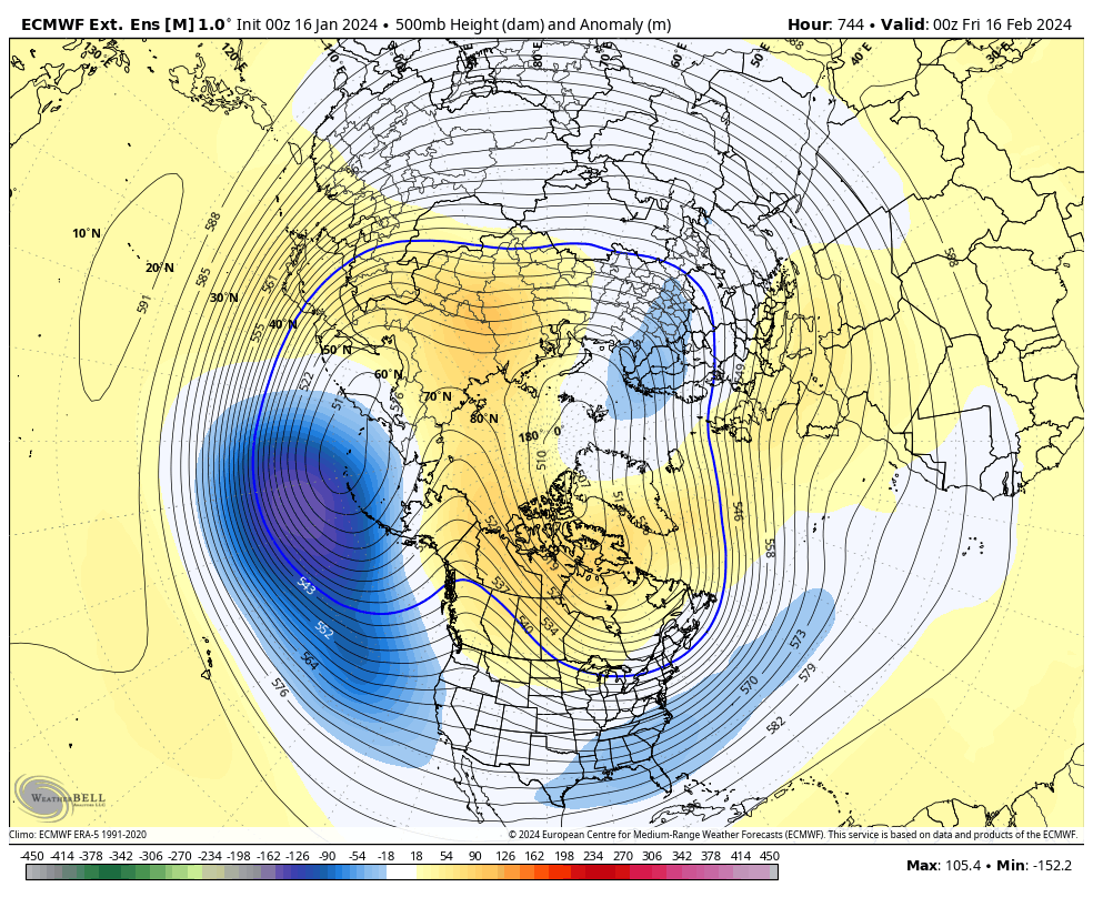
18z GEFS has one heck of a +NAO Jan 22-28.. +2-3std. I went back to 1948, and found the top 20 matching analogs for NAO events on those dates: Positive analogs: 1949, 1950, 1957, 1972, 1974, 1975, 1983, 1989, 1990, 1997 Negative analogs: 1958, 1964, 1966, 1975, 1980, 1987, 1998, 2005, 2007, 2021 I found that the NAO actually reverses the first 2 weeks of February! *This is interesting because 80-85% of the time when you are doing a roll forward with a strong one-sided atmospheric state, it usually continues. Feb 1st roll forward 500mb: https://ibb.co/1J075Z9 Feb 3 roll forward 500mb: https://ibb.co/4jWSWVx Feb 5: https://ibb.co/1qVZJFB Feb 7: https://ibb.co/3cCq7wC <- stronger -NAO signal appears Feb 9: https://ibb.co/kMwLd66 <- Strongest -NAO signal Feb 11: https://ibb.co/Vxm6pg2 Feb 13: https://ibb.co/NTDfhpJ Feb 4-13 -NAO matches current ongoing 10mb warming probable time to "downwell" and impact 500mb US Temps: https://ibb.co/PMZVS6s -
Jan/Early Feb Medium/Long Range Discussion Part 3
Stormchaserchuck1 replied to WinterWxLuvr's topic in Mid Atlantic
Stratosphere warming at this time of the year, correlates to -NAO in +20 days (happens about 2/3 times). https://ibb.co/z84pgX1 Today and tomorrow are the peaks in 10mb warming I think. -
Jan/Early Feb Medium/Long Range Discussion Part 3
Stormchaserchuck1 replied to WinterWxLuvr's topic in Mid Atlantic
The Globe has more precipitable water right now than it has ever had before (on satellite record), even into the higher latitudes.. 15-16 is #2. -
El Nino 2023-2024
Stormchaserchuck1 replied to George001's topic in Weather Forecasting and Discussion
The AN factor is a very positive NAO and AO (approaching +3), with +EPO being a factor some of the time too. Those are dominating, but the PNA is not part of that equation right now. -
Jan/Early Feb Medium/Long Range Discussion Part 3
Stormchaserchuck1 replied to WinterWxLuvr's topic in Mid Atlantic
In this example, the +NAO is a warm variable, yes. In the 3-5" snowfall, -NAO was a factor too, yes. Let's see if the +PNA/-EPO/+NAO and -PNA/+EPO/-NAO correlates in February.. the pattern is about 0.40 (+40% of the time) together in the last 5-11 years. And I see a high probability for this to happen next month. -
Would you bet against +PNA February?
Stormchaserchuck1 replied to Stormchaserchuck1's topic in Mid Atlantic
+PNA models have is extreme. I would bet against it.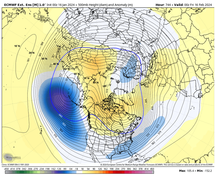
-
Jan Medium/Long Range Disco 2: Total Obliteration is Coming
Stormchaserchuck1 replied to Jebman's topic in Mid Atlantic
We should be fine by early February. There is a Stratosphere warming happening now https://ibb.co/59rRrb2 My issue is after the coldest day of the year Jan 27th, we have recently had a tendency to warm up real fast, especially in late February. -
El Nino 2023-2024
Stormchaserchuck1 replied to George001's topic in Weather Forecasting and Discussion
The southern part of the -NAO has been missing.. 50/50 low and N. Atlantic trough. There have been a lot of years where there was ridging over Greenland, and it was determined to be a neutral or positive NAO. Your stat seems impressive for the EC, but cold/warm there is part of the bottom half of the NAO calculation I think.