-
Posts
8,041 -
Joined
-
Last visited
About Wow
- Birthday 05/10/1984
Profile Information
-
Four Letter Airport Code For Weather Obs (Such as KDCA)
KCLT
-
Gender
Male
-
Location:
Mooresville, NC
Recent Profile Visitors
12,910 profile views
-
Jan 7 1996: Subject: Snow Prediction Update... <1/7 Early AM> From: [email protected] (A.K. Cruiser) Date: 1996/01/07 Message-ID: <[email protected]> Newsgroups: ne.weather [More Headers] ...Forecast Totals Update... It's extremely late and I'm not even going to break down all the 00Z model data for you. Suffice it to say that al models are going for at least as much snow as in previous runs, with more up into SE NY and SE N.E. A threat of mixing remains along coastal regions. My previous snowfall forecasts were low given model data at the time. With the new data AT LEAST as wet I felt I needed to up my forecast amounts considerably. My apologies to those of you in VA and S MD reading this as you're getting this update well into the storm. Even those of you in MD/DE will have probably been snowing a while before you get this (I'm posting this LATE Sat PM, but I believe most of you will get this Sun AM when you get up and log on). Without further ado, here are my updated totals... LYH, VA - 16" all snow (much has already fallen) ROA, VA - 20" all snow (much has already fallen) DAN, VA - 16" with some mixing with IP/ZR (much has already fallen) RIC, VA - 18" with some mixing with IP/ZR (some has already fallen) ORF, VA - 7" with much getting washed out with R (much already fallen) CHO, VA - 23" all snow (some has already fallen) NYG, VA - 22" with a brief mix with IP/ZR (some has already fallen) IAD, VA - 23" all snow BKW, WV - 15" all snow MGW, WV - 9" all snow MRB, WV - 12" all snow HGR, MD - 15" all snow BWI, MD - 22" all snow APG, MD - 24" all snow SBY, MD - 13" then mixing with or changing to IP/R DCA, DC - 19" with possible brief mix with IP (some already fallen) DOV, DE - 17" then mixing with IP/R ILG, DE - 21" then mixing with IP/ZR AOO, PA - 4" all snow HAR, PA - 16" all snow PHL, PA - 19" all snow AVP, PA - 8" all snow ABE, PA - 12" all snow IPT, PA - 10" all snow ACY, NJ - 15" then mixing with or changing to R TTN, NJ - 18" all snow EWR, NY - 16" all snow FOK, NY - 14" then mixing with R ISP, NY - 16" with a brief mix with IP NYC, NY - 15" all snow POU, NY - 10" all snow ALB, NY - 4" all snow BGM, NY - 4" all snow BDR, CT - 13" all snow GON, CT - 11" with brief mix with IP/R BDL, CT - 7" all snow BID, RI - 9" with mix with or change to R PVD, RI - 11" all snow CEF, MA - 3" all snow ORH, MA - 6" all snow BOS, MA - 8" all snow FMH, MA - 7" with mix with IP HYA, MA - 4" with mix with or change to IP/R MVY, MA - 4" with change to IP/R ASH, NH - 1" all snow PSM, NH - 2" all snow Well, that list is long enough... I hope it contains the city you want to see! Well, I'm off to bed... don't know if I'll update again given that we're already getting into the event, but I'll try to be online on IRC on #weather on the Undernet on Sun to give you updates from the NE burbs of DCA! Enjoy the snow!
-
Jan 6 1996: Subject: Snowstorm Update! ... <1/6> From: [email protected] (A.K. Cruiser) Date: 1996/01/06 Message-ID: <[email protected]> Newsgroups: ne.weather [More Headers] ...More Snow North And Lots For The DCA-BWI-PHL Corridor... Well, the 12Z models are in and their agreement is decent (although the NGM remains somewhat NW of most other models). The AVN has come around pretty closely to the ETA and the non-operational models are all close in agreement with the operational ones. Let's dive right into it: ETA: Absolutely astronomical precip totals from CHO, VA NE thru the DCA/BWI metro areas up into ACY. The ETA is forecasting amounts in the 2.5" (or more) range... liquid... yes, that's inches !! The ETA has a very sharp cutoff to the precip across S New England. Precip totals are up to 1.5" liquid in NYC with about .3" up into N CT and only about .1" in BOS. These totals may go up a bit beyond 48hrs, but due to the confluence aloft I doubt the heavy precip will get much further N. The sfc pressures indicate that the low is in no hurry to pull through the area. By Sun AM it's at about 1005mb sitting on the GA/SC coast. It dumps to 996mb and pulls NNE to HAT by Sun evening. Then it meanders to the S Delmarva coast by Mon AM with another low NE of that (a dual low structure). Upper levels are VERY impressive as the 500mb low cuts off with impressive vorticity swinging around it. This storm is completely wrapped up, but may open after 48hrs and head NE to ENE as a strong jet in the N stream doesn't allow it to head N. Almost every area in the NE receiving precip (as listed above) will be seeing snow... the exceptions will be SE of a RIC-NHK-SBY line where a mix or even a change to IP/R (or ZR) could occur. NGM: The NGM is only marginally more modest with precip as compared to the ETA. It's low track is, however, further W which brings in questions of R/IP across E VA, SE MD, and even SE NJ and far E L.I. The NGM takes the low from NW SC (it is an elongated low oriented N to S) to C NC at 996mb by Sun evening. By Mon morning it has deepened to 989mb and is centered over E VA (near or just E of RIC). The NGM also has a very tight precip gradient in the N. By 48hrs it has nothing in BOS while S coastal New England has about .3" liquid and LGA/JFK/NYC are around .7-.8" liquid. 1000mb temps indicate that SE VA and SE MD could change over to rain, while even DAN-CHO-DCA-BWI-ILG-ACY could mix with sleet or freezing rain. However, this mix occurs after the most precip has already occurred. VVs are hard to describe except to say that the upward motion is incredible across MD/DE/E VA/SE PA/NJ/and SE NY! Like the ETA the upper levels close off nicely with good vorticity screaming around the bottom of the upper low by 36/48hrs. Also, the confluent flow is once again evident across C New England... implying that the low will not affect areas that far N. However, it should be noted that NGM MOS does indicate moisture getting into C N.E. with significant snows (4-8") as far N as ALB-CON-BGR. AVN: The more progressive, less amplified AVN is coming around to the other models' solutions. By Sun AM it has a dual low structure with a low near HAT and another on the SC coast. By Sun evening the low has deepened to about 990mb, but is located about 100mi E of ORF. The low then bombs to 978mb and heads slowly N to about 100mi E of ACY by Mon morning. It then turns ENE and deepens to 975mb a few hundred miles E of Cape Cod. This track would result in all snow for everyone with the possible exception of ORF-WAL who would mix with IP/R. The AVN is a bit more tame on precip amounts, except in the N. It pumps out a "mere" 1-1.5" liquid from CHO-DCA-ACY-CHH with values just under an inch from BKW-IAD-PHL-LGA-BOS. Oddly, the AVN meteogram indicates higher amounts (1.8" liquid at IAD)... more in line with the ETA/NGM. NORAPS: The NORAPS is similar to the ETA. By Sun AM it has the low on the GA/SC border. By Sun night it gets to Cape Hatteras and slows to a crawl. It only get to just NE of ORF by Mon AM. This likely means major snowfalls from CHO-DCA-BWI-ILG. Indeed the precip fields reflect this. While it's extremely difficult to make out exact precip amounts on the maps, a best estimation yields 2-2.5" in the locales just listed with 1.5-2" in BKW-PHL-ACY and also on the S side from RIC-SBY. IPT to NYC seems to get about 1" with POU-BOS seeing a few tenths. UW-NMS: The UW model is really no less impressive. By Sun AM it has an elongated low on the GA/SC coast. By Sun night the low is NE of HAT... this represents a fairly progressive pattern. However, the progressive nature ends there... the low comes to a grinding halt and nearly drifts west a bit to just E of ORF. Precip is heaviest in the NW suburbs of DCA/BWI with 2-3" liquid falling. From CHO-DCA-BWI-ILG-ACY about 1.25" to 1.75" liquid falls. Up to PHL-LGA-CHH about .75" to 1.25" falls. Up to BOS about .2-.3" falls (by 48hrs). The UW gives areas SE of a RIC-NHK-SBY line mostly rain. RAMS: Looking at temps for the Mid-Atlantic for Sun AM it looks like the R/S line will be situated from the NW burbs of ORF Nward literally across the VA Tidewater. Then it bends due E to the SE shore of the Delmarva penninsula. Finally, it heads NNE through SBY then offshore north of Lewes Beach, DE and remains offshore, just barely, of ACY. Metro RIC-DCA-BWI-PHL range from the single digits at PHL, to the teens at DCA & BWI, to the low 20s at RIC. My thinking: Well, what can I say? Even given some important model discrepancies none gives the CHO-DCA-BWI-PHL-ILG-ACY regions less than 1" liquid. Those that give the least precip are generally those that are more progressive, which pulls less warm air in and may aid in high snow to liquid ratios... so even 1" exactly would probably be about one foot of snow in these areas. The most any model gives is up near two and a half feet!! While that's from a wet-biased model, it's bias is not huge and its sfc low position implies a little more precip after 12Z. Even the generally dry NGM is up between 1 and 2 feet in these regions and, with its very slow solution, probably also provides a little more snow after the 48hr period. For low positions I'm still going with the ETA, although the NGM seems to have hit it best over the last day or two. Given the more westward track I believe areas of coastal VA and coastal MD will change to rain. SE coastal NJ may see a brief changeover as well. Given the intense gradient near the coast on the hi res RAMS I believe any area of mixing will be narrow and will be SE of RIC NEward through SBY, DOV, ACY, E L.I., and Cape Cod and the Islands. Here are my updated accumulation forecasts: LYH, VA - 12" all snow (already snowing) ROA, VA - 13" all snow (already snowing) DAN, VA - 11" with brief sleet mix (already snowing) RIC, VA - 12" with brief sleet mix (already snowing) ORF, VA - 4" then rain (already snowing) WAL, VA - 8" then IP then R CHO, VA - 15" all snow (already snowing) IAD, VA - 13" all snow BKW, WV - 12" all snow (already snowing) MGW, WV - 5" all snow MRB, WV - 9" all snow HGR, MD - 10" all snow BWI, MD - 14" all snow APG, MD - 16" all snow SBY, MD - 10" then mixing with IP/R NHK, MD - 11" then mixing with IP/ZR DCA, DC - 14" all snow DOV, DE - 12" then mixing briefly with IP ILG, DE - 15" all snow AOO, PA - 5" all snow HAR, PA - 7" all snow PHL, PA - 11" all snow AVP, PA - 4" all snow IPT, PA - 3" all snow ABE, PA - 6" all snow ACY, NJ - 8" then mixing with IP/R TTN, NJ - 11" all snow EWR, NJ - 8" all snow BGM, NY - 2" all snow ALB, NY - 3" all snow POU, NY - 4" all snow NYC, NY - 7" all snow ISP, NY - 8" all snow FOK, NY - 6" then mixing with IP BDR, CT - 5" all snow BDL, CT - 3" all snow GON, CT - 4" all snow PVD, RI - 2" all snow ORH, MA - 1" all snow BOS, MA - 2" all snow FMH, MA - 4" all snow MVY, MA - 3" then mixing with IP/R Whew! Long list! You should know that, believe it or not, the totals are VERY conservative. In accordance with the wetter models all of these totals would be almost exactly doubled, except that measurable snows would also extend into N NY, VT, NH, and SE ME. Given model trends this very wet scenario is altogether possible. I'm simply playing it conservative because I can't even imagine the ballistic snowfall totals occurring in the Mid-Atlantic as forecast by the ETA and even the NGM. So, think of these as low-end snow totals. I *may* update once more, but these totals pretty much reflect my conservative thinking, but again, remember, snowfall totals literally double of all those listed above are possible!! Have fun.... I know I will!!! Gary
-
Jan 5 1996: Subject: Models Grappling W/ Snowstorm... <1/5> From: [email protected] (A.K. Cruiser) Date: 1996/01/05 Message-ID: <[email protected]> Newsgroups: ne.weather [More Headers] ...Models Continue Small, Important Differences... Latest 12Z model runs are quite intriguing. The AVN continues to be the progressive model... it still provides a decent storm for MD/DE/VA, but nothing collosal (except perhaps E VA). Meanwhile, the NGM is chugging the storm up the coastal plain... practically inland! The ETA is in between with other models generally in between as well. The most confounding aspect is that the most progressive models have the best upper level trof (or even a closed low!); the slowest, furthest NW models have the weakest, most open upper levels. This is 100% counter-intuitive. We'll attempt to disect all of the model info herein... NGM: The NGM has the weakest (though not weak) upper level trof, yet it is the slowest and furthest NW with its surface low. By 36hrs it has the low centered in C AL and then by 48hrs moves it to NW SC or SW NC. This brings some good snows, by 48hrs, to most of W & C VA and S WV. MD, DE, and E VA are just breaking into the good snows (with some on the ground already) by 12Z Sun. VVs are massive across C NC. This implies storm motion to the NE, up through C NC, E VA, and across the Delmarva. Maximum PVA by 48hrs is from NE AL NEward to E WV & N VA. The 500mb trof is buckling dramatically and is nearly closed off by 48 hrs. The flow is out of the SE as far N as NYC. The trof is still progressing, but also still buckling, so this is about as far as I'd expect measurable precip to get (PIT-NYC-PVD-HYA). Even the 300mb trof has been carved out very deeply. This scenario would line up the heaviest snow from C & E VA (except near the coast where rain would predominate) through C & E MD, DE, and far SE PA and S NJ. It would also mean some snow for L.I. and SE New England (though probably not at all heavy... just an inch or two). ETA: The ETA is the "imtermediate" of the regular short term models. With what was stated above for the NGM, you'll find this hard to believe, but the ETA has an even deeper trof with a closed (barely) low at 500mb. However, at the surface, the low scoots a bit faster east. It goes from S AL into E SC by 48hrs. However, of major importance is the VVS. With massive VVs occuring around ORF, this implies a turn more to the N. Given the precip field (being VERY similar to the NGM's), this should occur in time to provide VA/MD/DE with substantial snows. (Note: The precip field is very similar to the NGM and NGM 60hr MOS - though not the most reliable piece of data - shows heavy snows getting into MD beyond the 48hr period.... this and the VV trajectories give me high confidence that the ETA would still provide significant snows for those regions even given its slightly Ewardly displaced low center). AVN: The AVN remains the most progressive with the low. Interestingly, however, it doesn't appear to be showing that this fast, eastward motion will have a huge impact on Mid-Atlantic precip amounts (although they are toned down somewhat on the AVN). It still has a healthy bit of snow piling up in MD/DE/VA. In fact, it even provides SE PA and S NJ with a few inches of snow! Once again we see some discrepancy with the AVN closing off the 500mb low the best. By 60hrs the 500mb low is in C/E VA... this should put the axis of heaviest snow in a swath from ROA-BKW stretching ENE to RIC-NYG then further ENE to SBY-WAL. The precip field confirms this, as does the VV field. The AVN shears the system out much more than the ETA/NGM. It moves the storm from the FL panhandle to off of Cape Hatteras, NC by Sun morning. Still, as mentioned earlier, the strong SW flow aloft with the Gulf open for business provides ample moisture as far N as C WV, N MD, SE PA, and S NJ. (Note: Gridpoint data available off of McIDAS indicates that smoothing/interpolating/plotting techniques used on Purdue/IGES/etc may be indicating too little precip from ROA-CHO-IAD-APG-ILG SEward for about 50mi to RIC-NHK-DOV... further SE precip amnts are so high that the interpolation techniques really CAN'T screw it up and gridpoints are nearby.) UW-NMS: The UW model is the ultimate in an ETA/AVN compromise. How so?? Well, it has BOTH lows!!!! One is situated on the SC/GA coast while the other is just E of HAT (this is by Sun AM). At that point snow has begun to fall at a good clip (mod-hvy) thru NW NC, VA, and S WV with lighter amounts advancing into N WV, MD, far SE PA, DE, and S NJ. The heavier snow is progressing steadily ENE and should sweep into MD/DE shortly after 12Z Sun. The UW is the first model to aptly portray the sfc vs. upper level features. It is fairly progressive (though not as much as the AVN) and does NOT have a closed upper low by 12Z Sun. By 12Z Sun the UW already shows 6-10" of snow across S WV, all VA except the extreme N, and far NW NC. NORAPS: The NORAPS most closely favors the AVN, but it does lean somewhat toward the ETA. Its low, like the AVN, has made it up to HAT by 12Z Sun. However, like the ETA it holds tighter to the coast. Instead of being some 100mi offshore of HAT, NORAPS has it just S (due S... not at all E) of HAT. Snows have fallen quite heavily by that point across VA, S MD, and far NW NC. Moderate, significant (.5-.7" liquid) snows have fallen across most of the rest of MD, E WV, and most of DE. Light snows have occured from extreme S PA into far N MD and far N DE. CRAS: I expected the CRAS to be similar to the NGM, but a bit more on the progressive side. Why? It is based on the NGM model physics, but it incorporates additional data... data which I suspected would aid the forecast and cause it to converge toward the ETA/AVN. However, whether or not the CRAS is better than the NGM is in question, but it actually slows the system MORE than the NGM. By Sun AM it's got the low on the C AL/C GA border. The 500mb charts show a very well cut off low with precip streaking N and making excellent progress all the way through WV, MD, DE, and into S PA by Sun AM. The vortmax is S of any other model because it is stronger and carves the trof out very well. In fact, the trof is nearly negatively tilted. A forecast like this would change coastal VA/MD over to rain and put major snowfalls from C VA to C MD and all the way into E PA and NJ (and possibly far SE New England). Like the UW-NMS the CRAS is one of few models whose upper level charts jive well with its surface depiction. My thoughts: The models are coming into fair (but not "good") agreement. As such, the forecast has been clarified some. I'm going mainly with the ETA. The AVN, up until the last run, has been trending less progressive every successive run. While some models are close to the AVN, none are quite as progressive. On the other side of the coin is the NGM. The magnitude of ampilification that takes place in the trof is strongly supportive of the NGM. However, since the trof never goes negative we've got to leave in some decent progressive motion for the low. Thus the compromise solution should be best, and that leaves us with the ETA, the highest resolution model. The result is for the axis of heavy snow to occur from DAN-RIC-SBY. Much of WV, N VA, N & C MD, and DE will be an extremely tough call. While all models are calling for substantial snows in this area the gradient is very tight with some of the models simply calling for a dusting to an inch in S PA and S NJ (some other models are a bit more generous there). Meanwhile, extreme SE VA is going to be a tough call with the R/S/IP. If they stay all snow precip amounts could be high enough for them to receive one of their biggest snows in a LONG time. On the other hand, any mixing will drastically reduce the totals. Then the question of snow to liquid ratios comes up. In the long run, due to compaction, this is moot; but in the short term, especially with breezy conditions to follow the storm, this could be critical. I expect ratios in WV, N & C MD, and DE to be at least 12:1, possibly up to 15+:1. In RIC/ORF it'll be close to 10:1, maybe closer to 8:1. Below is a list of cities and amounts I expect them to receive. Remember, some of the snows come beyond the 48hr period, so this is VERY preliminary and is provided only so that you may get some idea of exactly what I'm thinking in terms of max amounts, area of heaviest snow, etc. LYH, VA - 9" all snow ROA, VA - 9" all snow DAN, VA - 10" all snow ORF, VA - 5" mixing with IP/R (or ZR) at times RIC, VA - 12" all snow CHO, VA - 9" all snow NYG, VA - 10" all snow WAL, VA - 8" with possible brief mix with R IAD, VA - 6" all snow DCA, DC - 7" all snow BKW, WV - 7" all snow MGW, WV - 3" all snow MRB, WV - 4" all snow HGR, MD - 4" all snow APG, MD - 5" all snow BWI, MD - 6" all snow NHK, MD - 10" all snow SBY, MD - 11" all snow DOV, DE - 8" all snow ILG, DE - 5" all snow HAR, PA - 2" all snow PHL, PA - 2" all snow AVP, PA - Trace snow ACY, NJ - 6" all snow TTN, NJ - 2" all snow EWR, NJ - <1" all snow ISP, NY - <1" all snow FOK, NY - 1" all snow CHH, MA - 1" all snow ACK, MA - 2" all snow MVY, MA - 2" all snow That's about it! If the NGM verifies snows will be heavier further N with a changeover possible from ORF to WAL. If the ETA verifies then amounts should be close to my totals given... maybe a touch heavier all around, but especially N. If the AVN verifies then the totals will be close to mine given with perhaps an inch shaven off here or there. These are my best estimates at this point. Stay tuned for updates as I'll try to tweek these numbers and improve confidence levels on each progressive run!! -Gary
-
Jan 4 1996: Subject: Models Revving Up For Mid-Atlantic... <1/4> From: [email protected] (A.K. Cruiser) Date: 1996/01/04 Message-ID: <[email protected]> Newsgroups: ne.weather [More Headers] ...New England in Question, Mid-Atlantic Find Your Shovels... Perhaps many folks in the Mid-Atlantic have had the opportunity to use their snow shovels once or twice already this year, but for most of us in the RIC-DCA-BWI corridor we haven't had the need. It's been 10 or 11 months since I used mine, but, if the models have any clue this go around, I'd better find it!! New England is less of a bet on this upcoming system, it depends on what model you buy into. As for the Mid-Atlantic Friday event, that looks to be generally a flurry system, so my energies will be concentrated on the Sat-Mon storm situation. Time is a bit short for me today and I have massive quantities of info to discuss, so let's get right to it... ETA: The short range models provide the "set-up" for the upcoming event and may clue us in on which long-range model is starting up the best. By 48hrs the ETA has an inverted trof from E LA NEward into E KY. The precip shield extends up to much of WV, VA, and NC with only N & E portions of the states not into precip by then. Most of this would be in the form of snow with heavy amounts beginning to fall across the S Appalachians. The vort ultimately responsible for further development is swinging through TX/OK. Of importance is the 500mb flow which indicates that precip should continue making Nward progress while heading E... at least up to the PA/MD & PA/NJ/DE borders (this assumes no further development which is likely a poor assumption). Also, much of the confluent flow is offshore which will allow the system to NOT get ripped apart until after it is offshore. NGM: The NGM is a hair slower than the ETA with its development and progression of things. By 12Z Sat it has an inverted trof from SE LA up to SE TN with a low embedded in S AL. Precip by that point extends into NE TN. The NGM upper flow is slightly flatter than the ETA. While the differences are subtle, this would favor a less developed, more progressive storm... though most of WV/MD/VA/DE should still get well into the precip shield. AVN: The AVN manages to take us deeper into the storm scenario. By 48hrs it has the inverted trof from SW LA NEward to SC TN. This is similar to, but a tad slower than, the ETA. At that point precip has spread into E KY, S WV, SW VA, and W NC. Then by Sat evening a low, oriented SSW to NNE is across the SE. Precip by then has reached extreme SW PA and most of MD southward. Moderate snows would be occurring from S WV, through SW VA, and into W NC. By Sun AM coastal cyclogenesis is just getting underway with a 1006mb low near ILM. The upper flow is buckling nicely and moderate to heavy snow has fallen across MD, DE, VA (away from the immediate coast), and inland NC. Lighter snows have reached as far N as N PA, S NY, and SW New England. That's the final period on the AVN. However, given the storm motion and the buckling occurring at upper levels I believe the implication would be that SE New England would get a period of light snow as well (VVs imply the best dynamics head out to sea south of New England). MRF: As usual, I've generally overridden the MRF with the 12Z AVN, but so so as to compare let's glance at the MRF. By Sat eve it has a weak (but intensifying) low over C GA. This is a bit faster than the newer AVN (or should I say, the new run is a bit slower). From there it brings the low to HAT by Sun AM and then races it NE to well E of Cape Cod (too far for any precip) by Sun eve. Oddly enough it still pumps out almost an inch (about .8" to .9") liquid across most of VA, MD, and DE (this is actually a bit more than the newer, slower AVN). ECMWF: The EC is the destructo-model for this storm. It has, by Sat AM, the inverted trof from SW LA to SE TN (and AVN/ETA compromise). Then by Sun AM is has a NNE/SSW oriented low on the C GA/C AL border. Once again this is in excellent agreement with the AVN, except that the AVN is faster (getting the low to this point some 12hrs faster). By Mon AM the low is bombing only 50-100mi E of the New Jersey coastline. It finally pulls off into Nova Scotia by Tue AM. Precip type actually comes into question from the Jersey coast to Long Island to extreme SE New England. There the snow may mix with rain at the height of the storm. Elsewhere (even SW toward DE, MD, and VA) the precip type is most definitely snow. UKMET: The UK is also quite slow. By Sat PM it has a weak wave off of SC, but the main culprit is buried down in Mexico! It emerges into the Gulf and off the GA coastline by Sun PM. Finally, it bombs and moves NE to well E of Cape Hatteras. This would confine the best snows to NC, VA, and perhaps WV, MD, and DE. Light snow would be possible to extreme S PA and S NJ. Other models: No time to get deeply into the other models, but here's a point of interest. Both the NORAPS and UW-NMS show a preliminary small event coming from the Gulf and scooting across the Mid-Atlantic on Sat. This delays (or precludes??? it's unclear) the main event. Precip from the preliminary low is light and somewhat insignificant (generally 1" or less). This looks slightly similar to the UK. The Canadian model is similar and develops this early system in lieu of the second one. As such it has a low centered over SC by Sat night; it hauls NE to well S of Cape Cod by Sun night. Still, precip in the Mid-Atlantic is not insignificant. It is just a moderate instead of a major snowstorm and occurs about 12hrs sooner. NWS: Just a quick note on the local (DC) NWS. I don't know what they're thinking. The latest forecast from them is calling for a chance of snow Sat & Mon, but only mostly cloudy Sun!! It seems to be quite obvious by the above models that Sunday is the most threatened day! My thinking: Well, every last one of the several models presented here are going for some type of a snow event in the Mid-Atlantic. Three critical questions must be answered... How much? When? How far north does it get? All three of these questions are meainly a function of the amplitude of the developing pattern. The short range operational models are converging on a solution between the MRF and ECMWF (which in the long term is much closer to the EC since the latest MRF is much closer to the EC than the previous MRF run). All of the short range non-operational models and the Canadian operational model are all pointing toward a lead-shortwave event where Sat aft into very early Sun instead of late Sat through midday Sun becomes the focus of the event. For the third question we've got the UK which may have trouble pushing precip as far N as the PA/MD border; and then there's the EC which takes the whole storm full force into New England. Which such a vast array of solutions and possibilities one might think this is another impossible forecasting event. However, I find it easier than previous events for two reasons: 1) Every model is calling for snows for VA, WV, MD, and DE... it's just the scope and timing that are of concern; 2) The models ...even some of the non-operational ones... have been converging on an EC/ MRF solution. Given that the AVN is an EC/MRF solution, but the ETA/NGM seem to be leaning a bit toward the MRF, I'm going with an EC/MRF blend shaded toward the MRF. This means amount-wise we're looking for heavy snow accumulations from inland NC to VA (away from the coast) and into S MD. A decent swath of moderate snows would surround that in W VA, WV, N MD, and DE. Light snows should spread as far N as C PA and C NJ. As the low pulls NE light snows may also spread across SE New England. I'm not going to pin exact numbers yet on "light", "moderate", and "heavy", but if it helps I USUALLY consider light = 1-3", moderate 4-8", and heavy 8-12". Timing looks to be entering extreme SW parts of the Northeast by late Sat aft and spreading NE into DE (and S NJ) by early Sun AM. One of my primary concerns is the forecasted very cold atmosphere... this could push snow totals up and, while this type of snow MAY easily compact the breezy (NOT windy) conditions behind the storm could keep things loose and cause some of the typical blowing snow problems. You should know that my confidence on timing, amounts, and the evolution of this system is still fairly low and you should check back for updates. However, given model convergence, my confidence in actually seeing a Sat/ Sun snowstorm across at least inland NC, inland VA, E WV, MD, and DE. But, anyone who lives in this area knows the frequency with which things can go wrong with the forecasted snow events, so stay tuned!! Gary
-
I had these archived and published on a site but no longer hosting it. Figured I would post them all here. These are the usenet posts from Gary Gray leading up to the Blizzard of '96. Keep history alive. Jan 3 1996: Subject: The Mid-Atlantic's Turn??... <1/3> From: [email protected] (A.K. Cruiser) Date: 1996/01/03 Message-ID: <[email protected]> Newsgroups: ne.weather [More Headers] Article Segment 1 of 3 (Get All 3 Segments) ...N.E. Storm Winding Down / Questions For M.A.... The storm in New England is winding down pretty much as expected and as we look into the future there are some minor questions in the near term and some major ones in the longer term. Most of these questions are for the Mid- Atlantic. As cold air digs in it *may* push the storm track too far south to truly concern NY and New England. However, on Fri (or early Sat) a minor event *could* cause some problems in the Mid-Atlantic. Then the major question comes in on Sun into early Mon with some models going for one of the biggest snowstorms in some time in the Mid-Atlantic (esp MD/VA/DE/NC) while the other models are going for pleasant weather for that period. On top of all that, no model has been exceedingly excellent in the 3-5 day range lately (a range which has been forecasted with a high degree of accuracy since Nov, up until the past week or two). So, on to the models... ETA: The ETA is painting a very interesting picture for Friday & Fri night for S PA, WV, MD, DE, VA, and NC. A weak low is diving into the Midwest and weakening. However, by 48hrs it has gotten just far enough south so that it appears to be starting to tap Gulf moisture. By 48hrs it has light snow across S WV, W VA, and NW NC. Jusy N of the low track is a swath of heavier (though not heavy... we're talking 2-4") snow. Upper levels are somewhat intriguing as well with hints of a secondary on the VV fields. However, a closed upper low well to the N is E far enough so that any secondary should kick E, out to sea. So, with the looks of the 48hr ETA it looks like a general 1-3" from S PA southward to N NC with N WV ESEward to C DE possibly picking up an inch or two more as they'll be under the best dynamics. *If* (and this is a big IF) the low picks up Gulf moisture or Atlantic moisture (which is altogether possible... esp the Gulf, but it would be very limited) snowfall would be a bit heavier. NGM: As is typical the NGM is dryer than the ETA across the Mid-Atlantic with the Fri event. By Fri AM it has light snowfall in WV, W MD, W VA, and extreme SW PA. This puts the precip shield a bit N of the ETA track as well. As the storm (and I use that term loosely as it isn't really a "storm") moves E it looks like max snowfall amounts will be up to 2" with no Gulf or Atlantic moisture getting involved. Best amnts will be across WV, MD, and DE. Vertical velocities and vorticity do not show any signs of coastal development. However, as on the ETA the vorticity advection, while not impressive and somewhat strung out, appears decent enough to provide steady, light snow thru WV, MD, N VA, DE, and perhaps up to S PA and S NJ. Subject: The Mid-Atlantic's Turn??... <1/3> From: [email protected] (A.K. Cruiser) Date: 1996/01/03 Message-ID: <[email protected]> Article Segment 2 of 3 (Get Previous Segment) (Get All 3 Segments) AVN: The AVN is the lightest on the snowfall amounts for the Mid-Atlantic on Friday. Through Friday evening it shows snowfall amounts maxing out at about 1" (possibly 2" with a decent snow to liquid ratio) across WV with generally .5" to 1" amounts stretching around WV from SW PA thru MD and N VA. Not to jump the gun, but sticking with precip fields... of more importance is the 72hr (12Z Sat) shot which shows precip streaking NE from an inverted trof along the Gulf coast. This would be the possible developing situation for Sun for the Mid-Atlantic. As you'll see later in my discussions of the longer range models the MRF was pretty much alone in forecasting nothing for Sun. Since the AVN essentially IS the MRF, this precip field is extremely critical to Sun forecasts. Back to Fri's minor event... the vorticity field is much the same as the ETA/NGM with the best PVA in WV, N VA, S PA, and MD. Again the surface low is weak and, while the AVN does show some sign of secondary development, it is insignificant. Again, the AVN is very light with precip. By 12Z Sat a strong vortmax is digging S through the Plains; a low is taking shape in W TX (with some signs of an inverted trof in the W Gulf); precip is already, by that time, streaking NEward as far NE as NE TN. While there are still massive questions about the track of this system, given the progress by 12Z Sat, this would undoubtedly bring snows to WV, VA (except S where it could be rain), MD, and possibly DE by Sat PM. MRF: There's little to discuss on the MRF... it's rather boring. There are already small, but significant differences between the 00Z MRF and the 12Z AVN, with the AVN considerably stronger with the system diving south toward TX & the Gulf by Sat AM. The precip field differences also speak volumes. While the MRF clearly shears precip E... not reaching further N than S MS, S AL, and S GA by Sat eve, as discussed above, the AVN has precip nearly in SW VA by Sat morning!! This obviously flat, shearing pattern on the MRF does a number on the sfc low as well. It's nearly indescernable through the period and the weekend into early next week looks simply tranquil for the entire NE. UKMET: The UKMET is more amplified with the southern stream low as we get on into the weekend. However, it's still not terribly strong. It has a decent low and bombs it off the coast, but does so far enough south and east so as to preclude a major snow event in the Mid-Atlantic. Given the typically vast northward expanse of overrunning in Gulf moisture situations it is still likely that the Mid-Atlantic could see some light snow on Sun (except coastal areas S of WAL/ORF where enough maritime air will keep a thick enough mild low level layer to keep things as rain). ECMWF: The EC is the most bullish with snowfall potential in Mid-Atlantic regions. In fact, the EC may even be amplified enough to clip E New England as the rapidly deepening low hooks NE. The EC is nearly a dream scenario for snow lovers in the Mid-Atlantic. It brings the low far enough N to help usher in at least moderate amounts of Gulf moisture; however, it remains far enough S to keep the warm air locked into SC/GA/ FL area. The low is not terribly intense when it passes to the south, also it may be a bit too far E when it bombs, so the Mid-Atlantic may not get buried in the EC scenario, but given the rarity of a decent snowstorm in the M.A. (esp lately) the EC scenario portrays one of the best snows in a while. <Thread<Picture: [Post Message]> Post Message Subject: The Mid-Atlantic's Turn??... <1/3> From: [email protected] (A.K. Cruiser) Date: 1996/01/03 Message-ID: <[email protected]> Article Segment 3 of 3 (Get Previous Segment) (Get All 3 Segments) My take... Well, if it's not obvious from the above the current strong storm in New England will drive cold air southward far enough to supress much REAL action in New England for the next several days. So, focus shifts to the Atlantic. However, first in passing let me note that snowfall totals so far across New England... those that I have seen so far... are all on the high side of what was forecasted (except in a few select coastal areas). In fact, most of the totals I'm seeing are in the one-foot area with snow still coming down; this is certainly on the high end of most forecasts I've heard and I hope it quiets some of the skeptics that piped up after the last event. On to the forecast... Friday, while not much of a system, remains a tough call. Precip across WV, N VA, S PA, MD, and N DE could range anywhere from about .03" (obviously an estimate... I simply mean between .01" & .05") up to near .35" with snow to liquid ratios anywhere from 10:1 to 15:1. This puts minimum snowfall possibilities at .3" with maximums up just of 5"... and this assumes that one of the models is right. Of course, those numbers are on the extremes of the scale, so I'm generally going 1-3". I expect the 3" to be confined in the mountains with generally 1" elsewhere except under the best dynamics (N WV into N MD) where 2-3" could fall. S WV, C VA, extreme S MD, S DE, SE PA, and S NJ could get a dusting. ...As for the more questionable situation on late Sat into Sun I have decent confidence that the bombing low will miss everyone (although extreme SE New England could get clipped with a period of very light snow). My concern is more when the low moves across the SE U.S. (and is slowly intensifying). Which of the three long range models will it track closest to?? I am VERY reluctant to commit to any one of them given the vast differences it would present in sensable weather, however, given the latest 12Z AVN run it pretty well negates the MRF. Still it isn't quite as vigorous as the EC. So, I'm going with an AVN/EC/UK blend. This means generally light snows from N WV, S PA, and S NJ southward. Areas of C VA could get isolated more hefty amounts. Areas SE of a WAL-ORF-DAN-RDU line are looking at a mix (perhaps not plain rain as the cold air aloft is thick and VERY cold). In any event, remember this is a very complex weather system (what else is new?!?!?)... so I intend to post updates on this... but these are my thoughts for now. Snow exiting New England next several hours; light snow for Mid-Atlantic (C VA & S WV northward to S PA and perhaps S NJ) on Fri with generally 1-2" amounts; break for late Fri and much of Sat; Sat PM into Sun again light (perhaps moderate) snows for much of the same Mid-Atlantic region with some mixed precip in S & E VA. -Gary
-
Nope. Just eye candy. Still got a ways to go
-
lol probably will happen anyway! I'm not afraid to roll the dice!
-
It's been so long i've lost my ski gloves and hat. Did a late night Amazon purchase after that Euro run last night.
-
what is the upper level setup following this? ugh i need to get a wxbell account
-
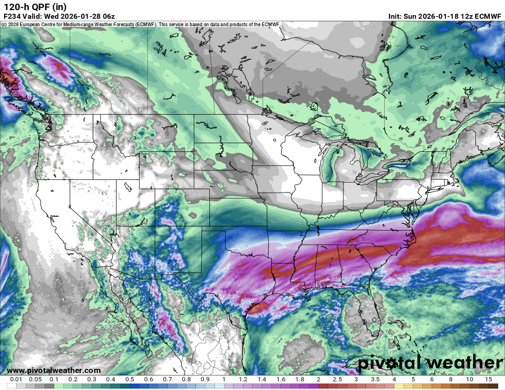
It's a weenie run for the ages. Jan 88 on steroids.
-
That's what I'm here for. Christmas blizzard of '24
-
18z GFS looking like the earlier Euro AI run with a huge PNA ridge spiking up to the pole. That AI run ended with a what looked like a sustained long wave pattern with a split jet and PV over SE Canada heading to the new year.
-
SST trend last 7 days to show that cooling (and warming to the east). Certainly taking the punch out of the -PDO a bit.
-
The Pacific is looking like the best I've seen in years if this pans out. Given how this last cold pattern worked out, I think it's looking more likely. SST trends last 7 days...
-
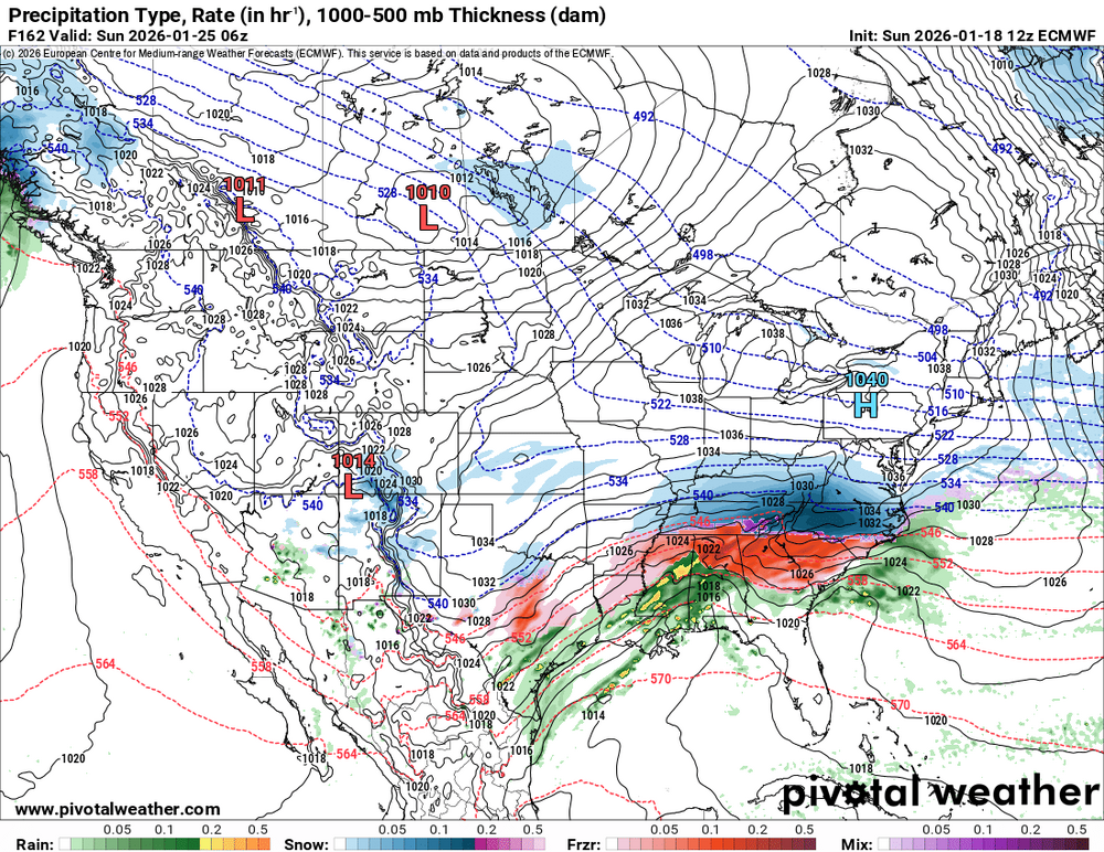
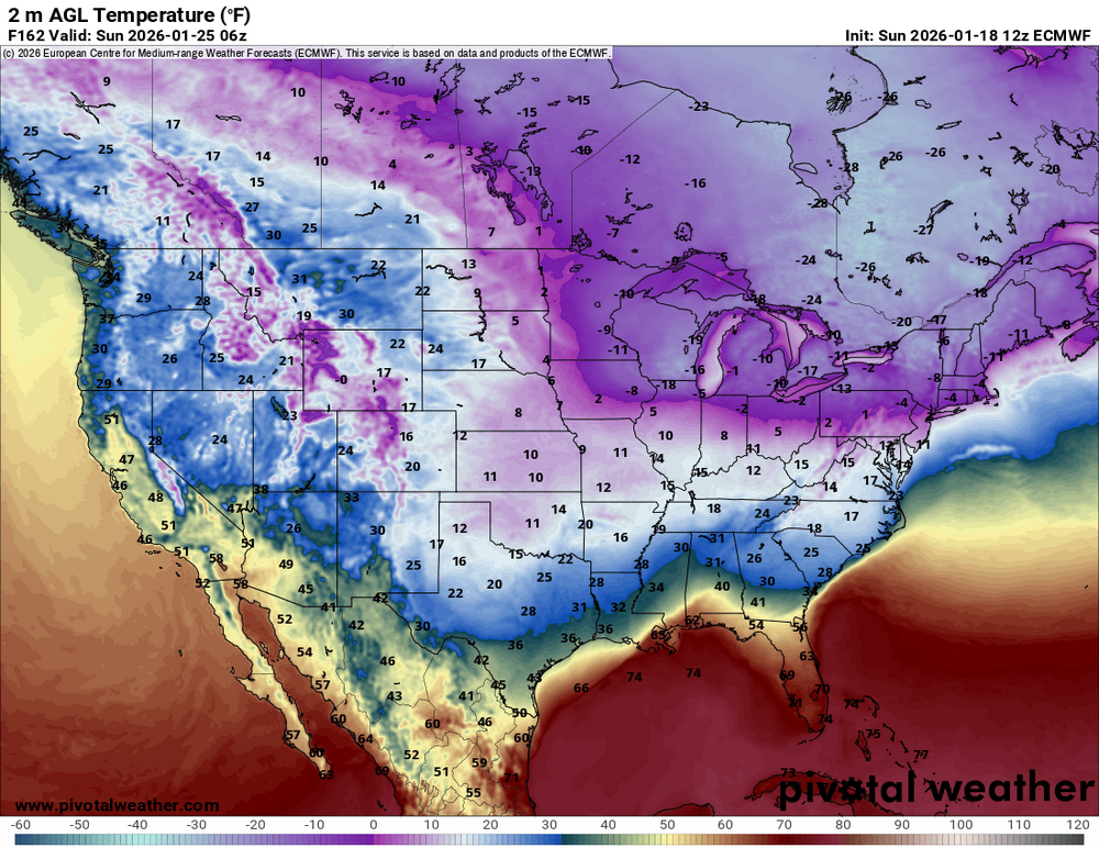
So the 12z ECMWF attempted a triple phaser today. The leading s/w stole most of the thunder on the sfc reflection (still blasts the NE of course) but the upper air pattern is gold Look at that PNA ridge! 850mb temps.. almost brings -20C down to FL.