RU848789
Members-
Posts
3,614 -
Joined
-
Last visited
Content Type
Profiles
Blogs
Forums
American Weather
Media Demo
Store
Gallery
Everything posted by RU848789
-
Disagree - these look the same to me; maybe the slightest tick north. Also the map you posted goes out to 4 pm Weds - yes there is some very light snow, but I doubt any of it will accumulate with very light intensity during daylight with temps above 32F.
-
There's obviously some reason the NWS has the snowfall forecast higher than most models - maybe they're buying the NAM, as they look very close. And I just noticed that the NWS had put up advisories for SE Bucks, Mercer and Monmouth (must've been looking at an old map), so Middlesex/Somerset aren't that far away from advisory level snows.
-
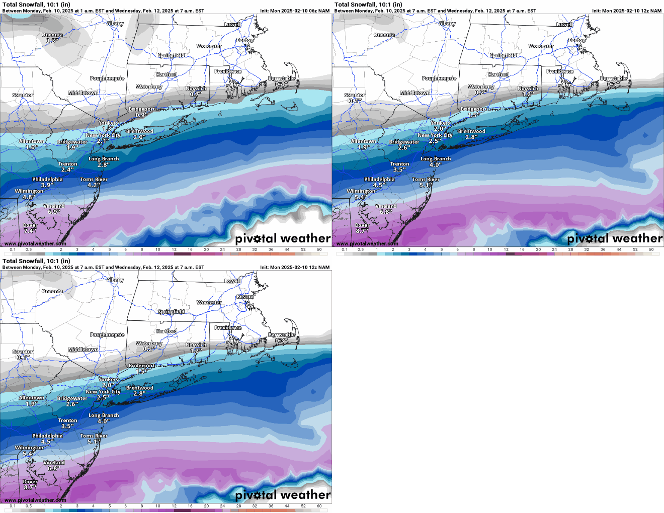
Zoomed 12Z vs 6Z NAM - nice! NYC at 2.5" (10:1; Kuchera for NYC is about 1.2) and only 30 miles from 4".
-
Thanks, but why wouldn't you include Warren County on your maps? i get it's not part of the formal NYC MSA, but it part of the larger CMSA and just looks funny, geographically to be omitted, as it's closer to NYC than a bunch of the counties in the DMA. Just my $0.02. https://en.wikipedia.org/wiki/New_York_metropolitan_area
-
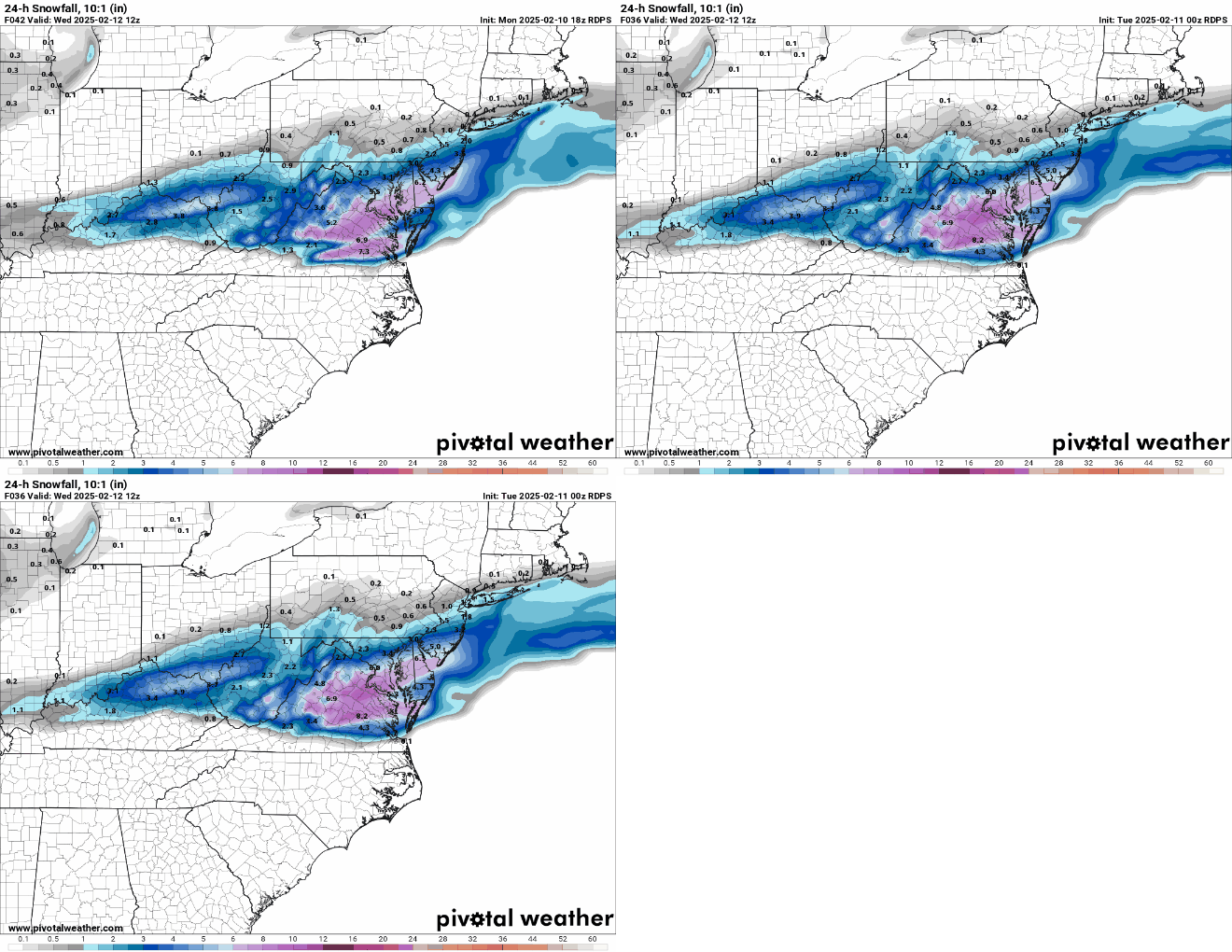
Here's the NWS-Philly versions of those maps. Agree that no model shows anything that high right now, but I always thought the 10% high end maps were about potential and those amounts would only require about a 75-100 mile north shift of the snow shield. This also appears to be only for wave 1, with wave 2 not having any precip until after 7 pm Weds. This is reflected in their updated AFD. Area Forecast Discussion National Weather Service Mount Holly NJ 314 AM EST Mon Feb 10 2025 SHORT TERM /6 PM THIS EVENING THROUGH WEDNESDAY/... Snow will fall Tuesday night through Wednesday morning with a primary focus over the eastern shores of Maryland, Delaware, and southern New Jersey, where 4 to 6 inches of snow will fall. From along the I-95 corridor to the Fall Line, 2 to 3 inches of snow will fall, with 1 to 2 inches over the southern Poconos, northern New Jersey, and the Lehigh Valley. Will keep the Winter Storm Watch in effect for the eastern shores of Maryland, Delaware, and southern New Jersey. Behind the departure of the secondary low, the first low that was over the Gulf Coast states will depart off the Mid-Atlantic coast Wednesday morning. Another low organizes and develops over the Ark-LA-Tex area Wednesday morning, tracks northeast during the day, and tracks through western Pennsylvania and western New York Wednesday night as another secondary low develops out ahead of it. That low passes through New Jersey and will be off the Jersey Shore late Wednesday night. Precip Wednesday and Wednesday night will feature more in the way of a mixed bag of wintry precip, first over Delmarva and southern New Jersey Wednesday morning, then the wintry mix lifts north through the day, and Wednesday night. Wintry mix changes to plain rain from south to north Wednesday night. During this time, snowfall will range from 1 to 2 inches over the southern half of the forecast area, and from 2 to 3 inches over the northern half.
-
As I had mentioned, I was way too pessimistic here, as we had a decent amount of heavy sleet and heavy freezing rain in the ~90 minutes after this post, so when I went out to shovel around 12:30 am, after the precip had stopped, I measured 1.6" of slop, which probably contained 0.5-0.6" of QPF (I didn't do a ratio, but saw a radar estimate in that range). If I had to guess it was 0.5" of snow (0.05" QPF), which I saw early, plus 1.1" of 2.5:1 sleet (0.44" QPF) and 0.1" ZR for 0.59" QPF. That's a guess, but I can absolutely tell you that this slop kicked my ass (and shoulder, lol) as it felt like a 5-6" of snow shoveling, as it took almost 2 hours.The 1.6" was also probably more, but had compacted with the alternating sleet and rain, but anyway, it brings my seasonal total up to 12.8". Now let's get some more next week.
-
As I had mentioned, I was way too pessimistic here, as we had a decent amount of heavy sleet and heavy freezing rain in the ~90 minutes after this post, so when I went out to shovel around 12:30 am, after the precip had stopped, I measured 1.6" of slop, which probably contained 0.5-0.6" of QPF (I didn't do a ratio, but saw a radar estimate in that range). If I had to guess it was 0.5" of snow (0.05" QPF), which I saw early, plus 1.1" of 2.5:1 sleet (0.44" QPF) and 0.1" ZR for 0.59" QPF. That's a guess, but I can absolutely tell you that this slop kicked my ass (and shoulder, lol) as it felt like a 5-6" of snow shoveling, as it took almost 2 hours. But on the plus side, I did get to meet @Allsnowas he was plowing our street and saw me out there in my RU gear and asked if I was RU#s, so we chatted for a bit which was nice and then we both went back to work. The 1.6" was also probably more, but had compacted with the alternating sleet and rain, but anyway, it brings my seasonal total up to 12.8". Now let's get some more next week.
-
The last hour has been a rollercoaster with precip flipping back and forth between moderate to heavy freezing rain and sleet at 30F. Crazy storm with the back edge of the precip approaching.
-
Spoke too soon. Just flipped back to pouring sleet - no idea what will happen next, lol.
-
Switched over to freezing rain a few minutes ago, earlier than expected, so I just took my final measurement of 1.25" of sleet/snow, bringing our season total up to 12.4". Disappointing we didn't get the 2.5" of snow/sleet I guesstimated and especially would've liked more snow, but that's the way it goes sometimes. Not loving having an hour or more of ZR, which could put down 0.1" or more of ice with temps at 29F.
-
Nice! Did you wake up the zookeeper to make a measurement, since the precip type changed? They're supposed to - otherwise the sleet will compact the snow and we'll see another low measurement. https://theconversation.com/how-is-snowfall-measured-a-meteorologist-explains-how-volunteers-tally-up-winter-storms-175628
-
As of 9:30 pm we have 1.0" of snow/sleet mix on the ground at 28F. Went for a drive locally on 287, 1, and 531 in Metuchen/Edison just to see what it was like and everything, including 287 and 1 was snow-covered and slippery with people going 30-40 mph mostly. 1010 WINS said lots of accidents (mostly fender benders) out there; I saw one on the shoulder of 287. Was pouring alternating snow and sleet and mix and now we're just about all sleet, although it seems like "larger" sleet pellets than usual for some reason and judging by a few other posts in our area, we're locked in to heavy sleet for awhile. Would rather have snow, but it's still pretty gorgeous out there. Radar still looks healthy.
-
As of 8:30 pm, roughly 1 hour into the decent rate precip, it's pouring snow again (lots of switching with sleet here) and we have 0.4" otg at 30F with RH up to 80%.
-
As of 8:30 pm, roughly 1 hour into the decent rate precip, it's pouring snow again (lots of switching) and we have 0.4" otg at 30F with RH up to 80%.
-
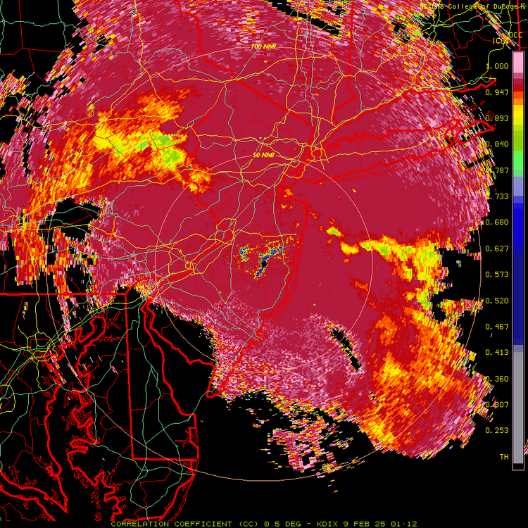
I just don't see the line on dual-pol, although I see the big bright blob out by Clinton on 78. Back to mostly snow again. Regardless, I'm very happy with the precip intensity and radar out west and I'll take mod/heavy sleet for 3 more hours if I have to, lol.
-
As of 8:10 pm we're at 31F (but still only about 70% RH so not saturated at ground level yet) and we've gotten about 0.3" in 30 minutes with a very slick sleet layer on the bottom and then we had great snow for 10-15 minutes and now we're a mix again. Going to be an interesting night.
-
Was very cool, but then it turned back to a 50/50 mix - wonder if I'll be seeing a lot of that back and forth...


