RU848789
Members-
Posts
3,614 -
Joined
-
Last visited
Content Type
Profiles
Blogs
Forums
American Weather
Media Demo
Store
Gallery
Everything posted by RU848789
-
The last 45 minutes of light snow did give us another 0.1" to bring the final storm total up to 2.0", as it's down to flurries now and there don't look to be any more bands coming. Was a bit less than my 2.8" prediction and the NWS prediction of 2.4" for Metuchen, but that's fine as I got to enjoy a really pretty snowfall; this brings our seasonal total up to 14.8", which is only a couple of inches behind where we should be, on average. Time to go shovel, which I love to do in the middle of the night when there's not a soul around. Edit - 30 minutes to shovel - way easier than the 2 hr shovel for Saturday's storm, which was 1.6" in depth vs. the 2" of depth tonight - that's why it's all about the mass, as tonight's mass was about 1/3 that of Saturday's.
- 338 replies
-
- 4
-

-

-
Been light snow for the last 15-20 minutes, but the radar would make one think it's just some flurries. I'm thinking we've likely gotten that additional 0.1" to get to 2.0", but will wait until the snow stops before taking a final measurement - should be in the next 15-20 minutes.
- 338 replies
-
- 1
-

-
Wow, it held on for a good half hour of moderate to heavy snow through about 3:05 am and as of 3:00 am, we're up to 1.9", as we got 1/4" the last hour.. It's been snowing more lightly to moderately since about 3:05 am and it's possible we'll eke out another 0.1" to get to 2.0" for the storm. Temp is at 30F still.
- 338 replies
-
- 1
-

-
Heaviest snow of the night right now - let's see how long it can hold on...
- 338 replies
-
- 1
-

-
Well, that lull ended up hurting and that big blob aimed at us kind of disintegrated so we only got 0.15" the past hour, bringing our total up to 1.65" as of 2:00 am; temp is still 30F. Radar, in general, shows the back edge of the decent precip in Bucks/Montco, but it does look aimed at us so maybe we can eke out enough to get to 2", but I'm not counting on it. There's also always the possibility we can pick up another 0.1 or 0.2" after that from some lighter snow showers.
- 338 replies
-
Forgot to post here, but As of 1 am, we have 1.5" of snow for another 0.3" the last hour and despite being in what looks like a radar lull, it's still snowing close to moderately (the small flakes might not be showing up great on the radar) and it looks like a healthy blob of snow is aimed at us and entering Somerset County right now. Hoping that batch can put us over 2". Still 30F. Just walked around a bit and threw some snowballs - the snow packs decently as it has some moisture, but it's nowhere near wet or slushy. Beautiful snowstorm even if we don't get crushed. Any reports from Philly?
-
As of 1 am, we have 1.5" of snow for another 0.3" the last hour and despite being in what looks like a radar lull, it's still snowing close to moderately (the small flakes might not be showing up great on the radar) and it looks like a healthy blob of snow is aimed at us and entering Somerset County right now. Hoping that batch can put us over 2". Still 30F. Just walked around a bit and threw some snowballs - the snow packs decently as it has some moisture, but it's nowhere near wet or slushy.
- 338 replies
-
As of 12 am, we have 1.2" of snow for 0.3" the last hour and it's still snowing moderately, but we're missing the heavier bands just to our SE by 5-10 miles, so at this point, thinking about 2", assuming 3 more hours of this, unless we finally get a few heavy bands. 2" reported in Hazlet and 2.8" in Howell and oddly 2" in Basking Ridge, which was supposed to get less than here, but you never know where the best banding will set up. 1" in Piscataway and 4" in Toms River.
- 338 replies
-
- 1
-

-
Haven't given a single thought to future rain. Get outside man and enjoy the snow while you can - it's freakin' gorgeous out there right now.
- 338 replies
-
- 2
-

-
As of 11 pm we have 0.9" of snow for 0.3" last hour. Snowing close to moderately now; still mostly small flakes though, but guessing maybe 11-12:1 ratios (will probably measure this one - the snow/sleet/ZR mess was impossible lol). Radar still looking very good for most of NJ, except Sussex/Warren, which is no surprise, and in NYC/LI. 30F outside and just went for a drive for fun and to get some groceries and all of the untreated side roads are snow covered, while the county roads are slushy to wet, as they've been treated and Route 1 and 287, which get heavily treated and have a lot of traffic, are just wet. This shows the contrast to Saturday, where 287 and 1 were a snowy/sleety mess, completely covered, as that precip was heavier and sleet simply doesn't melt as fast from air temps or salt (low surface area). As I've said many times, an inch of mostly sleet is much more impactful than an inch of snow.
- 338 replies
-
- 2
-

-
As of 10 pm, we have 0.6" of snow for exactly 1/4" this past hour also, with snow continuing to fall between lightly and moderately at 30F. Radar has filed in nicely to the SW and NW, so folks in the rest of CNJ/NNJ NW of about 202/287 ought to at least get an inch or so from this storm. Not sure I'll make it to my 2.8" prediction, but I think 2+" is very attainable, with another 4-5 hours of decent snowfall likely and maybe a bit heavier than so far, as has been forecast from 10 pm to 2 am roughly.
- 338 replies
-
Radar looks to be filling in in Montco/Bucks a bit, which "should" make it into Somerset and probably eastern Hunterdon and then hopefully Morris.. NWS standing by their forecast, as per below, but they've been wrong before... Area Forecast Discussion National Weather Service Mount Holly NJ 910 PM EST Tue Feb 11 2025 .NEAR TERM /THROUGH WEDNESDAY/... 910 PM...Snow continues to fall over roughly the southern 60 percent of the forecast area with the heaviest continuing to fall over portions of Delmarva into southern NJ. Portions of Sussex County Delaware have already seen over 6 inches. All in all, no major changes to the forecast with the mid evening update. The storm total snowfall forecast remains similar with 4-8 inches of total snow expected in areas where the Winter Storm Warnings remain in effect, and as referenced above with the frontogenetic band, likely an area of localized maxima above 8 inches over southern interior portions of Delaware possibly extending into portions of the MD eastern shore Counties. However extreme southern portions of DE along with the Delware Beaches zone will likely see some rain and sleet mixing in at times. Areas within the Winter Weather Advisory across northern DE, southeast PA, and Central NJ are still expected to receive 2-4 inches of total snowfall. Across northeast PA and into northern NJ, snowfall totals up to 2 inches are expected. The majority of the snowfall will be this evening and early on tonight.
- 338 replies
-
As of 9 pm we have 0.35" of snow on the ground for exactly 1/4" the last hour, with snow falling between lightly and moderately at 31F. Everything is covered and slippery. We're still not far from the NW edge of the accumulating snow - not sure if folks in Somerset or especially Hunterdon or Morris are getting much. Heavy band just went through Mercer and southern Middlesex, but missed to my SE.
- 338 replies
-
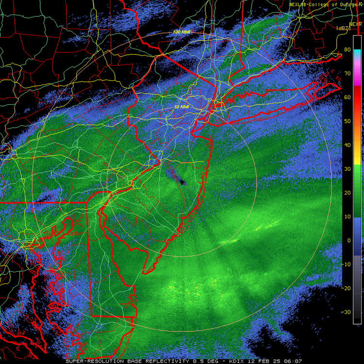
As of 8 pm, we have 0.1" otg (just about 1/4"/hr rate) at 31F and snowing lightly to moderately - nice dendrites. The radar shows the decent snowfall rates falling off quickly about 10 miles NW of here, so this could be a close call all night unless the radar follows the NAMs and some other models and fills in towards Sussex/Warren counties for awhile.
- 338 replies
-
- 1
-

-
18Z NAM3km has been a very good predicted match to the actual radar the past couple of hours as per below for 8 pm. And I know past performance is no guarantee of future returns, but here's what the 18Z NAM returned. Just sayin'. And as an aside, the NWS-NYC discussion I posted earlier, explaining how the HRRR doesn't do well in northern fringe situations that still have lift, looks to be prescient. So far, as I hate spiking the ball early.
- 338 replies
-
Snow started lightly here around 7:25 pm at 32F and we now have an official dusting as of 7:45 pm, but more importantly, intensity has picked up to moderate - this looks like 1/4" per hour snowfall and we hopefully have 6-8 hours of snow, so 2-3" is definitely possible, especially if we get some heavier rates by 9-10 pm as expected.
- 338 replies
-
Snowing in Robbinsville and Asbury Park and even flurries on the south shore of LI.
- 338 replies
-
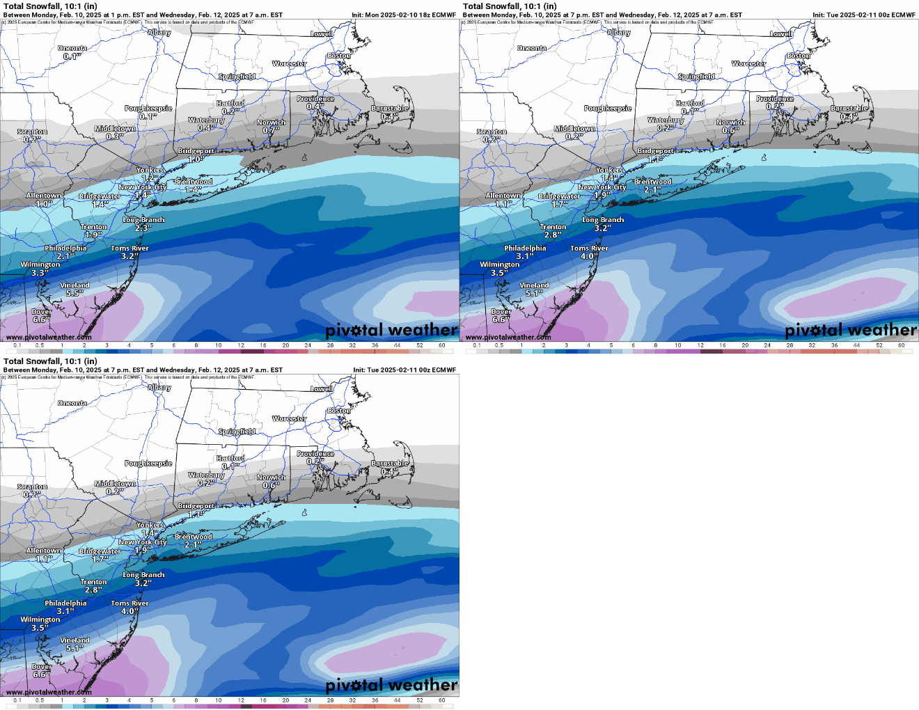
Almost forgot - prediction time., I'll go with 2.8" for our house, as I think the storm will overperform a bit vs. the 2.4" forecast for Metuchen, due to good snow/liquid ratios and the jet streak dynamics the NWS has discussed, along with decent frontogenetics as per several models and most of the models increasing snowfall (a little bit) at 12/18Z (except the HRRR which is a major outlier and is obviously being ignored by the NWS and others). Would be a bit disappointed with <2", but will still enjoy it.
-
One of the best AFDs I've read in awhile, as I thought they did a great job of explaining their rationale for rejecting the HRRR (better than I did, which is not a surprise) and for why they think the storm will overperform a bit (good jet streak and frontogenesis) and deliver 12-13:1 ratio snow. Area Forecast Discussion National Weather Service New York NY 359 PM EST Tue Feb 11 2025 .NEAR TERM /UNTIL 6 AM WEDNESDAY MORNING/... Low pressure beginning to develop over the southeast this afternoon and will push ENE off the southern Middle Atlantic this evening into tonight. The region will continue to lie on the northern periphery of the precip shield. The latest model trends all support a bump up in liquid equivalent with around a few hundredths well inland, around a tenth southern portions of the Lower Hudson Valley and coastal CT, 0.15-0.20" in the NYC metro, and around 0.25" across Long Island. The NAM still appears to be the wettest of the guidance across the area, especially across the southern half with as much as 0.3" in NYC and near 0.4" across eastern Long Island. The 18z NAM has lowered QPF just slightly, but overall remains consistent with its last several cycles. Most of the 12z CAMs have come into better agreement with the rest of the model consensus. The HRRR is one of the drier models, but have noted it be to dry at times in previous events when the region is on the northern periphery. There are also several key ingredients that support the trend upward in liquid equivalent and resulting snow accumulation including a stronger 700mb frontogenesis signal combining with strong upper divergence from a 170-190 kt departing polar jet streak to our north. Models do tend to struggle with the combination of these features and have seen several past events over perform with lift accompanying a strong upper jet. The other factor is the majority of the model suite is indicating enhancement of the precip shield from Southern NJ up into the area at least the southeast portion of the area tonight as the coastal low emerges off the coast. Thermal profiles are also supporting an all snow event. Soundings indicate deep ice saturation within the dendritic growth zone for several hours tonight, especially across Long Island and portions of the NYC metro. The strongest lift appears to occur between 10pm and 2am with a decrease the rest of the night. The snow will begin to overspread from the south tonight between 7-9pm, becoming steady and continuing through the early morning hours. There is a period between about 10pm and 2am where snowfall rates could run between 0.25-0.50" per hour. There is even a low probability snowfall rates could briefly approach 1" per hour across Long Island from around 11pm-1am as the strongest forcing and deepest moisture combine. Snowfall rates will drop off from west to east from 3am to 5am. Some flurries may linger towards day break, but accumulating snow should end before sunrise. Snow to liquid ratios look higher with this event given we are on the northern periphery of the low and soundings show more of an ice saturation signal over one with deeper supercooled water saturation signal. For these reasons have gone closer to a 12-13:1 ratio. Updated snow totals are around 3 inches with potential of a few spots approaching 4 inches across Long Island. Elsewhere across the NYC metro and much of NE NJ and coastal CT, generally 1-2 inches are forecast. Locations closer to the south shore in Staten Island and southern Brooklyn and southern Queens could see up to 3 inches. More locations could see closer to 3 inches in the NYC metro and NE NJ if a wetter and further north trend continues. Amounts across the interior will be lower and generally less than an inch as this area is closer to subsidence from the high building in from the north.
-
I was living in Highland Park, NJ at the time, but don't recall that storm - how did it end up? What are your thoughts for tonight (siap)?
-
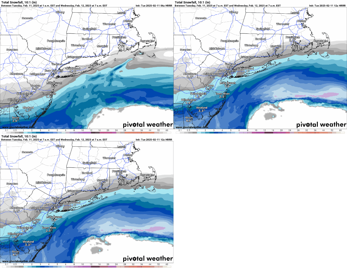
The HRRR has been pretty far off on the radar forecast vs. actual, especially for the 6Z run, which had low snowfall like 18Z does (12Z HRRR had much more snow to the NW), plus it's a significant outlier. The other day the NAM was a significant outlier and only ended up being partly right, i.e., for areas SW of about Allentown to NB, where most got little snow and a lot of sleet and ZR, but it got the precip amount and type NE of that line completely wrong, especially for NENJ/NYC/LI and the part it got right was in its wheelhouse of thermals aloft, whereas the HRRR isn't known for having some great skill in coastal snowfall. So, I'm ignoring it and obviously the NWS and others are too. Let's hope they're all correct.
-
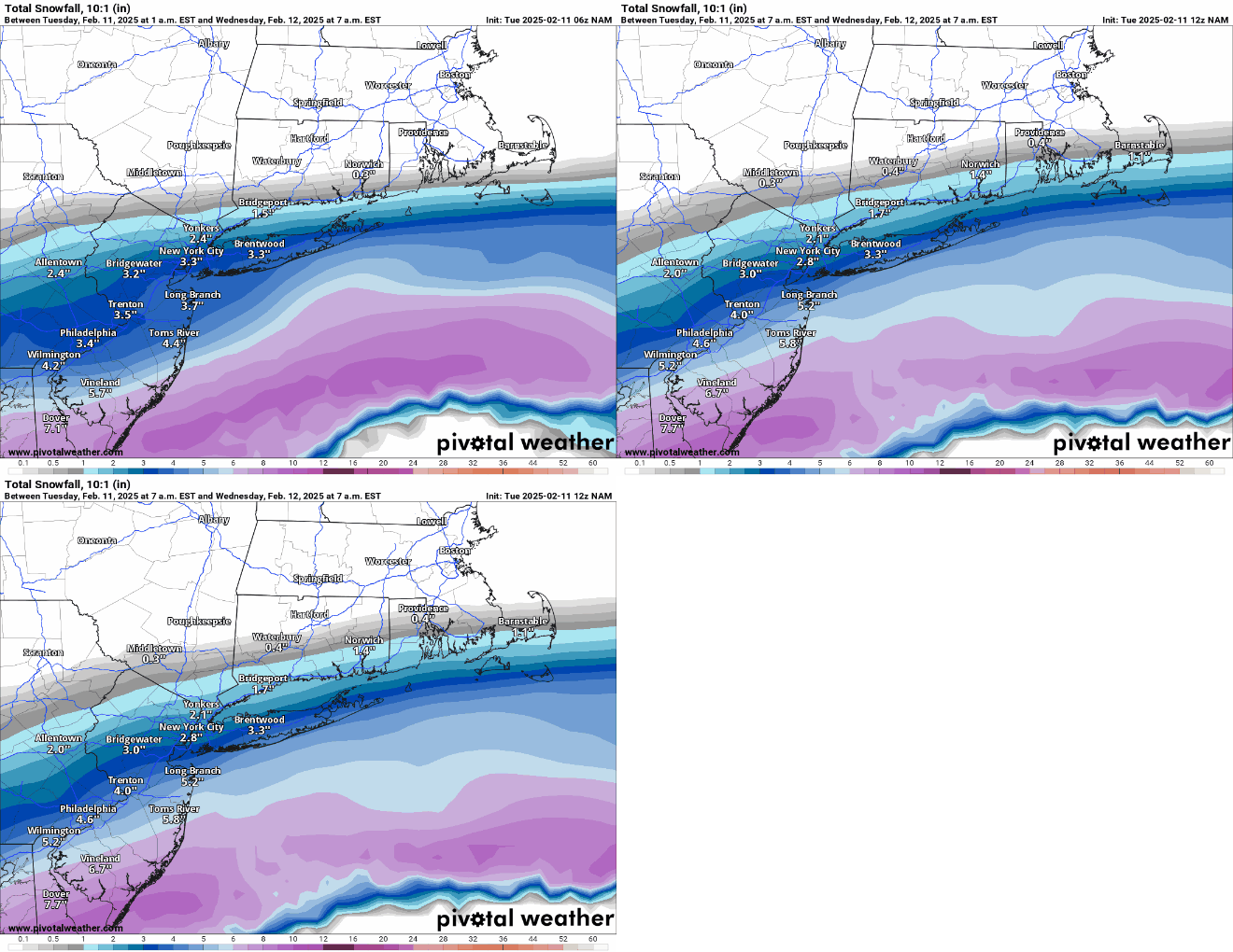
Heavier snowfall moved significantly NW up through 95 (SW of about NB) and was the same or slightly less along and NW of 95 for NENJ/NYC. The 1" line actually bumped north a little bit, but that's likely noise. Note though that the NAM is warmer than some models near the NJ coast (33-34F) so the Kuchera ratios are <1 there .
-
The risk of a major bust low just went down as the HRRR model, which was way less snowy than the other models, finally moved significantly further north...it's still on the low side of the models, but it's no longer a crazy outlier
-
Here's the NWS map for wave 1 only from 7 am today through 7 am Weds and below that is the map for wave 2 only from 7 am Weds thru 7 am Thurs. I just stumbled upon the NWS snowfall portal tool yesterday from a poster on the RU board and it's very cool if folks haven't seen it. It allows one to pick any NWS office area and timeframe up through 66 hours, creating snowfall maps and to hover one's cursor over any location to get the snowfall for that period (a much better version of the point-and-click feature)....and there's a button to create "official NWS snowfall maps" like the one below. The link for this is well hidden, lol, on the winter weather page just above the usual maps where it says, "Click here for the NWS Probabilistic Precipitation Portal" - this link then comes up: https://www.wpc.ncep.noaa.gov/Prob_Precip/


