

RU848789
-
Posts
4,002 -
Joined
-
Last visited
Content Type
Profiles
Blogs
Forums
American Weather
Media Demo
Store
Gallery
Everything posted by RU848789
-
2/13 Significant/Major Winter Storm Discussion & Observations
RU848789 replied to Northof78's topic in New York City Metro
Nov 18 might be my favorite example. It was also an example where the NWS completely overestimated marginal temp impacts on a high intensity snowfall, both with regard to mixing in the column and melting on the ground - and I was posting all the same things for that storm as I have been for this one - intensity is everything (or at least a lot of it). -
2/13 Significant/Major Winter Storm Discussion & Observations
RU848789 replied to Northof78's topic in New York City Metro
Come on in, the water's fine!! -
2/13 Significant/Major Winter Storm Discussion & Observations
RU848789 replied to Northof78's topic in New York City Metro
You may be right, but several models have you over 6" at 10:1 or over 4" at 6-7:1. -
2/13 Significant/Major Winter Storm Discussion & Observations
RU848789 replied to Northof78's topic in New York City Metro
Think TWC forecast is the best I've seen and they've really gotten much better the past several years (remember, they were the only ones who nailed Jan-2015) with some very good mets and model discussions these days. I think the NWS adustments at 4 am were in the right direction, but not enough, especially towards 276/195 and the coast, where I think TWC is likely to be better. We'll see of course. -
2/13 Significant/Major Winter Storm Discussion & Observations
RU848789 replied to Northof78's topic in New York City Metro
If we get the 1-2" per hour rates advertised by most of the models, the snow will accumulate even on paved surfaces at 33-34F - will take a little while to start, but remember, once there's a layer of snow, the "surface" is now 32F slush, which will make subsequent accumulation much easier than on 33-34F wet ground and the heat transfer coefficient of air is 1/20th that of liquid/solid (wet ground), so melting will be greatly reduced once we're only relying on vapor phase driven melting. Trust me on this. We've seen it countless times in March/April, but the key is having >1" per hour intensity sustained for awhile. And I'm not talking about accumulation on treated, paved high traffic streets that are likely 38F or more. Also, even if accumulations on city streets and treated highways is minimal in some cases, visibility is going to be terrible with heavy snow falling, which will make driving difficult by itself. -
2/13 Significant/Major Winter Storm Discussion & Observations
RU848789 replied to Northof78's topic in New York City Metro
So, NWS-Philly issued warnings for Poconos/Sussex for 9-12" of snow, for the Lehigh Valley, Morris, Warren for 7-10" of snow and for Berks, NW Bucks, Hunterdon and Somerset for 4-7" of snow. However, they inexplicably left Middlesex out of the warning (or at least the northern half, which will likely do as well as southern Somerset/Hunterdon), putting Middlesex, Mercer, Lower Bucks and Montco (but no Monmouth) under advisories for 2-4" of snow. These are all fairly close to what I was thinking above. Also, the NWS-NYC issued watches for Union/Essex/Hudson and NYC/LI for 5-8" and warnings for everywhere north of there for 7-10" of snow, which makes sense to me, even if those amounts are a little bit higher than I expected (I don't like to guess too high and felt I was already out on a limb predicting much more snow than they were) - they are in line with what models are showing. NWS-Philly just updated their map below as did NWS-NYC... Also, revising my initial guess of 2" for my house from Saturday night to 7.2" as my final prediction for my house (usually make these ~24 hrs before the snow starts). -
2/13 Significant/Major Winter Storm Discussion & Observations
RU848789 replied to Northof78's topic in New York City Metro
NAMed! The 6Z NAM looks a lot like the 0Z Euro and is still the coldest model at the surface with temps around 32F along 95 during the snowfall (so Kuchera ratios are in the 8:1 range for 95 and 10:1 or more N of 78). Nice start to the 6Z suite. -
2/13 Significant/Major Winter Storm Discussion & Observations
RU848789 replied to Northof78's topic in New York City Metro
Thought it would be helpful to have all of the relevant model snowfall maps from 0Z in one place, as I'm constantly trying to remember where they might be in a thread especially when looking back at a storm which I sometimes do. I'm only including the 10:1 ratio maps for brevity and because those at least give one the total precip as snow, too, which is important. Pretty impressive all together. I think we've all discussed ad nauseum how for this storm, especially for areas S of 78 and east of maybe the NJ TPK, surface temps are likely to be in the 33-35F range, leading to melting/compaction and there could be a warm nose aloft for some period leading to some sleet, both of which would make the snow ratio produced up high in the sky (which should be >10:1 given great dynamics in the DGZ) something perhaps considerably less on the ground as accumulated snow (maybe 7-8:1 and could be even lower at the coast), so take these maps as starting points for how much snow might actually accumulate. -
2/13 Significant/Major Winter Storm Discussion & Observations
RU848789 replied to Northof78's topic in New York City Metro
Just for giggles, here's my guess as to what we'll see from the NWS at 4 am: I'd guess that the NWS-Philly will upgrade snowfall amounts at 4 am and go with advisories for 2-5" for most of CNJ (Hunterdon/Somerset/Middlesex/Mercer/Monmouth) and for Bucks, Montco, Berks and maybe W. Chester and warnings for 6-10" or more for all of the counties north of 78 in PA/NJ (Poconos/Lehigh Valley and Sussex/Morris/Warren) and that the NWS-NYC will also go with advisories for 2-5" for Union/Essex/Hudson, NYC/LI and warnings for 6-10" for Passaic/Bergen and SE NY north of the Bronx and all of CT. This is probably the hardest I've disagreed with the NWS ever or at least since Nov-18, which was somewhat similar with 1-2" of sloppy snow/mix predicted until the event was underway, but then everyone in CNJ/NNJ/NYC etc. got 4-8" and a nightmare on the roads as the snow hit around noon, like a wall. -
2/13 Significant/Major Winter Storm Discussion & Observations
RU848789 replied to Northof78's topic in New York City Metro
the WB maps show very little difference between 10:1 and Kuchera which is surprising with temps 34-36F during the snow; the Pivotal maps show a ~50% difference, at least along 95, where the ratios are likely to be the worst (vs 78 and north). -
2/13 Significant/Major Winter Storm Discussion & Observations
RU848789 replied to Northof78's topic in New York City Metro
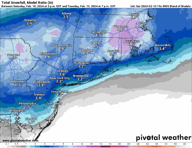
Major improvement for 95/coast in particular...although this is 10:1 and with surface temps around 34-36F while it's snowing, these numbers would likely be about half what is shown for 95/coast.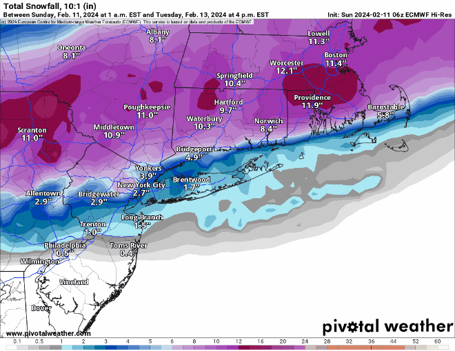
-
2/13 Significant/Major Winter Storm Discussion & Observations
RU848789 replied to Northof78's topic in New York City Metro
Cool. Yep that was me and still is, lol. I used to have a website at Merck where I'd post snowfall info and forecasts from the NWS and other pros (I linked to this site and pro sites all the time; I also did/do tropical weather), as well as trying to explain what was going on (and the various outcome probabilities) to mostly non-scientists and people could sign up for email notifications when I had an update - had about 750 people on that list when I retired and of those I now have about 200 people from work (many I never knew) on my weather emails (also have a family/friends list of about 200). Started doing this about 25 years ago when I was on the site crisis management team (which included snowstorm impacts). And there's FB and a couple of RU sports boards where I post similar info. Keeps me busy, lol. I don't post these long weather posts here because 90% of posters already know what's going on. Can you share the name or IM it? Just curious who it is. -
2/13 Significant/Major Winter Storm Discussion & Observations
RU848789 replied to Northof78's topic in New York City Metro
Loving the Mesos, which are now in their range, showing a 3" line from roughly Trenton to Sandy Hook and a 5-6" line along 78 (at 10:1, which is unlikely for the RGEM with surface temps on the mid-30s, but possible for the colder NAM with surface temps in the 32-33F range). Maybe we can get lucky with the globals and beyond... And it's looking very likely that for 95, even if there's little accumulation on the roads, heavy snowfall rates and poor visibility will be hitting right during the morning rush hour, so the storm will still be impactful. And for areas along/N of 78 this will likely be a very impactful storm unless we see last minute track shift north. Also, for coastal areas, moderate flooding is looking likely with the storm as per the NWS AFD and could also see 40-45 mph gusts at the coast at the height of the storm Tuesday morning (more like 30-35 mph inland). https://forecast.weather.gov/product.php?site=NWS&issuedby=PHI&product=AFD&format=CI&version=1&glossary=1&highlight=off -
2/13 Significant/Major Winter Storm Discussion & Observations
RU848789 replied to Northof78's topic in New York City Metro
Maybe if I stay awake and keep posting good things will keep happening, lol. the 6Z GFS just came out snowier than 0Z, especially for areas between 195 and 78, including NYC. Maybe the "trend" north has stopped. -
2/13 Significant/Major Winter Storm Discussion & Observations
RU848789 replied to Northof78's topic in New York City Metro
Although the 6Z RGEM just came out snowier for 95/coast (this is why forecasting can be so tough) with the 3" line from Trenton to Sandy Hook and the 6" line roughly along 78 (at 10:1 which is not realistic for 95 and SE of 95 with surface temps 34-35F). Still an improvement vs. 0Z. -
2/13 Significant/Major Winter Storm Discussion & Observations
RU848789 replied to Northof78's topic in New York City Metro
Well, the last holdout for significant snow for areas south of 78 and along 95 from Philly to NYC, the NAM, has caved to the rest of the guidance, with much less snow south of 78 at 6Z vs. 0Z. The 6" line is now along 78 insted of from Philly to Pt. Pleasant. Oh well. The 0Z CMC still had 6" along and N of 276/195, but it was much warmer than the NAM at the surface, so ratios would be far worse. Would be nice to not have this keep moving warmer and wetter so that those of us along 95 might still get the 1-3" shown by the NBM. I'll be bold and go with 2" for my house in Metuchen vs. 2.5" on the NBM and 1.5" from the NWS. -
Thanks!! Not trying to be argumentative over the whole accumulation-intensity-surface temp topic - just trying to point out that there are situations where that can apply and this was looking like it could be one - as modeled with very high rates. I completely get that there are many things that can torpedo that and that the reality is we're likely to get a fair amount less than many of the models are showing at 10:1 given warm surface temps on most models. Another question for you since you've been very helpful on the NBM. Any idea why the NBM snowfall along 95 and SE of there would have co me down from the end of the 19Z NBM map, below, to what should be the beginning of the 01Z map below, when the only 0Z model that should be in that NBM would be the NAM and the NAM is quite snowy for 95 and towards the coast at 0Z (the NAM always comes out first as far as I know). I would think the NBM for the 0Z suite would start off kind of high or at least higher than the end of the 18Z suite when only adding in a snowy NAM. Any insights would be appreciated, again.
-
2/13 Significant/Major Winter Storm Discussion & Observations
RU848789 replied to Northof78's topic in New York City Metro
Well at least we have the NAM on our side. Also nice that it goes down to 31-32F for 95 from Trenton to NYC between 4 and 7 am and stays there, so we shouldn't have much trouble accumulating with good intensity snowfall (6+" in <6 hrs) and cold surface temps. Soundings also look good along 95 with sleet at 4 am then snow the rest of the way with a column well below 32F. Ratios are also pretty good even for 95 (0.8-0.9 if one believes the Kuchera), but a lot lower at the NJ coast. As modeled of course. How do we make this happen? -
2/13 Significant/Major Winter Storm Discussion & Observations
RU848789 replied to Northof78's topic in New York City Metro
The Euro gets down to 32F along 95 by 7 am and most of the snow then falls with temps 31-32F along 95 and colder inland, which is why ratios are near 10:1 along 95 and higher than that inland. The other models do look to bottom out at the 33-34F range around 7 am and are likely there for 3-4 hours on either side of that with the heavy snow, but hard to know that with models only showing temp data every 6 hours and temps being in the mid 30s at 1 am and 1 pm. Need more granular data... -
2/13 Significant/Major Winter Storm Discussion & Observations
RU848789 replied to Northof78's topic in New York City Metro
Schwing!! Coldest model with temps getting down to 31-32F by 7 am and staying there for the rest of the storm, which is why the Kuchera isn't much lower than 10:1 for 95 and is 12:1 or more well inland. -
2/13 Significant/Major Winter Storm Discussion & Observations
RU848789 replied to Northof78's topic in New York City Metro
Don - all valid thermal/column/accumulation concerns, but if the modeling is correct and along 95 we get 1-1.5" per hour snowfall rates with almost the entire column below 32F, but just the surface maybe at 33-35F, I would think we'd actually do at least Kuchera ratios or higher, i.e., 0.7-0.8, as the falling crystals would likely be decent dendrites from the DGZ to near the surface and only melt a little near the surface, hopefully not enough to lead to significant compaction and low ratios. I liken this to some of the late March/April storms we've had with high intensity, but decent ratios (not 0.5 at least)/accumulations although that's relying on memory and with your treasure trove of data you have access to, perhaps those storms did have poor ratios (although decent accumulations were seen). If the models verify and we do get at least ok ratios, then we could be looking at 6" or more for 95 - and with heavy paste, we could then have substantial power outages. Will be interesting to see. -
Hey @wdrag- I recall you explaining what the NBM snowfall "model ratio" meant but can't recall it or find it. Any chance you (or anyone who knows) could refresh our memory? Thanks!
-
2/13 Significant/Major Winter Storm Discussion & Observations
RU848789 replied to Northof78's topic in New York City Metro
Well, to be fair, for the last 2+ years most winter storms have underperformed vs. what forecasts predicted, some terribly so, so people get gunshy and would rather predict 2-4" and then have to bump that up to 4-8" early in a storm than to have to have a 4-8" storm fizzle down to 1-2". I get it. -
2/13 Significant/Major Winter Storm Discussion & Observations
RU848789 replied to Northof78's topic in New York City Metro
NYC has truly been screwed. I live just 25 miles SW of midtown and we have 7.3" this winter, which is weak, but not atrocious. -
2/13 Significant/Major Winter Storm Discussion & Observations
RU848789 replied to Northof78's topic in New York City Metro
here it is...not too different from the NBM (slightly less snowy).


