RU848789
Members-
Posts
3,614 -
Joined
-
Last visited
Content Type
Profiles
Blogs
Forums
American Weather
Media Demo
Store
Gallery
Everything posted by RU848789
-
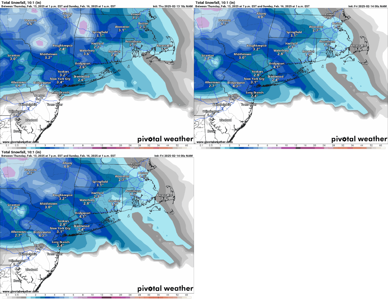
Just posted about that, lol. No, accumulation on pavement is unlikely south of 78 IMO, assuming 33-34F surface temps and given at least some impact prior to about 4 pm from indirect sunlight in mid-Feb. Unless we get some nice banding with rates more than 1/4" per hour (which was our rate for Tuesday), which I haven't seen much indication of.
-
Same here and that was before seeing the non-snowy NAMs. I just have trouble seeing much accumulation for areas south of 78 at 33-34F with light to moderate intensity, especially prior to about 4 pm, as the sun angle matters in mid-Feb with marginal temps and low intensity.
-
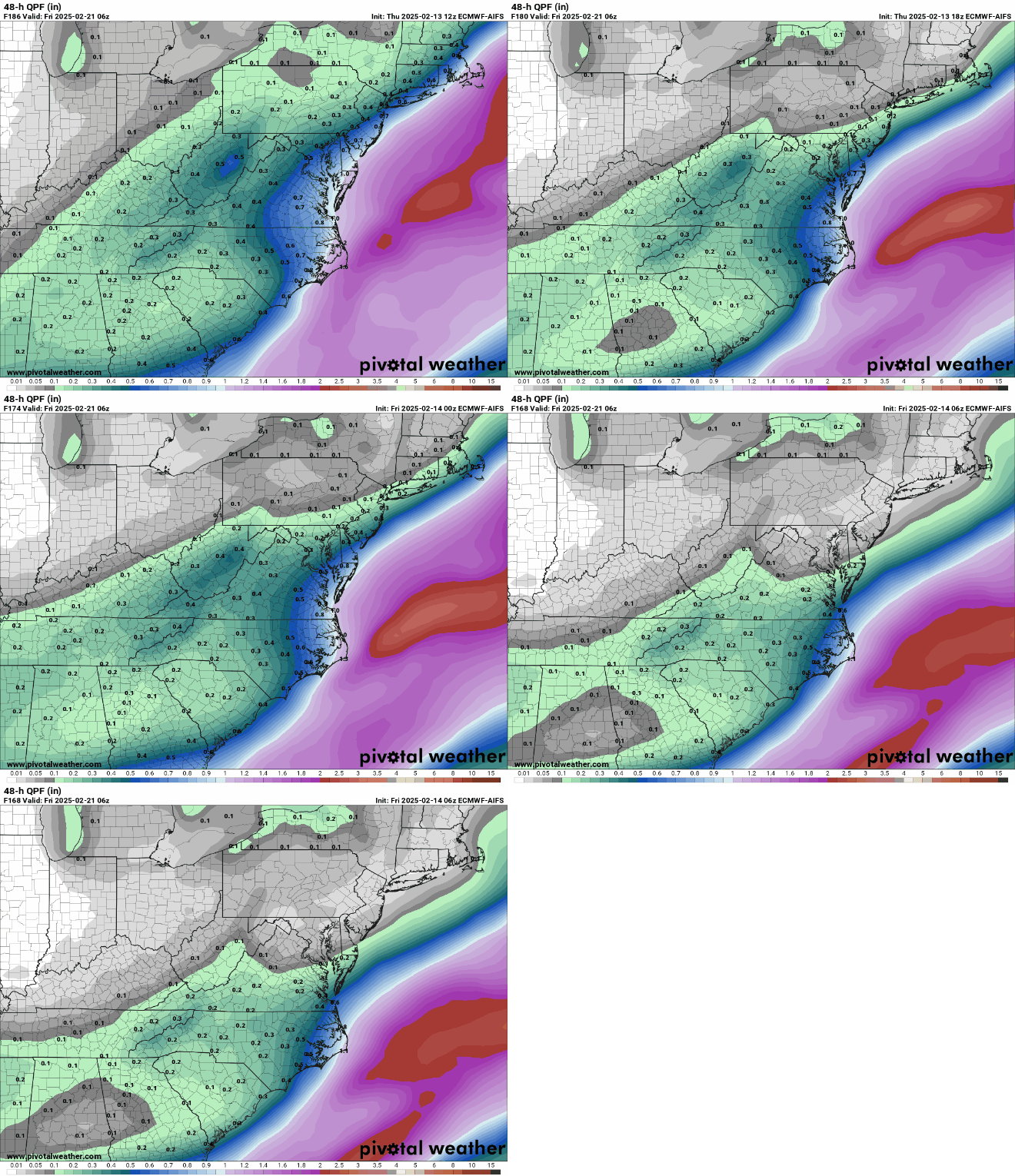
Obviously, the incredible consensus for a major to historic snowstorm from the 4 global Op models, as well as the unusually snowy ensemble means for these models, are fantastic to see, but we know there's no guarantees in this game. Which is why the AIFS has me at least a bit worried, as it's been pretty good on tracks this winter...let's hope the AIFS is just wrong and comes back to a better track and wetter solution than the trend we've seen over the last 24 hours...
-
NWS snow and precip maps (1-1.5" of rain for most of us after the initial snow thump) and map of advisories for 2-3" (southernmost counties on the map) and 2-4" (north of those counties) are below, along with the NWS snow map for the NE US - huge snows for interior NY and New England, especially the ski resorts.
-
Yes, but those were both under 10" storms (at least for me) and I guess I was thinking about 12"+ storms. If somehow this holds onto decent consensus from day 6 through a 12"+ outcome, that would be unprecedented, IMO and pretty damn cool. It also occurs to me that There's likely only a few thousand people who know about this in the entire world right now, but there will be millions who know about it by tomorrow night, as this shit is about to go viral, big time.
-
I've been tracking storms since you were probably in grammar school and I've never seen consensus on an HECS like this 6 days out, let alone even 3-4 days out. It's incredibly exciting, but we all know how complex and uncertain NWP is, so assuming we're going to see an outcome like what we just saw from the models is a bit unrealistic - but possible. It's the "possible" part that's so exciting. Thanks, as always, for your efforts and for those from the other mets/experts.
-
And the Euro goes BOOM!! too. 4 for 4, 6 days out. Can only go downhill from here, lol.
-
So, the UK is the least snowy of the 3 major global models that have run so far and it shows 12-18" for the entire region for 2/20 and for DC to Boston really. The least snowy. The GFS shows the most with 18-32" and the CMC shows 12-24". I've never seen anything like this before in decades of tracking storms - consensus on an historic east coast snowstorm 6 days out. Obviously, storms like this are rare, so it might not happen at all, but this is as strong a signal for a significant to major snowstorm one is ever likely to see this far out. Euro up next and I have no idea what to expect. What's bigger than BECS?
-
Meh, still the least snowy model and no improvement vs. 12Z. Also, with modest rates and temps above 32F, this means difficulty accumulating during daylight (sun angle starting to play a bigger role now) and even after dark if temps are 33-34F, as per the model.
-
Finally got the NWS-Philly map update showing increased snowfall across the board, matching the increases seen for the NWS-NYC snowfall map above. I'd be pretty happy with 2" more snow, as per the map, even though I know it's going to get washed away - just fun to see and nice to add to the seasonal total. Still 42 hours until the precip starts, so we know more changes are likely; as the 2/8 and 2/11 mixed events, I'm concerned about getting more sleet/less snow than forecast.
-
NWS-NYC updated with increased snowfall, but NWS-Philly hasn't updated yet (even though their AFD discusses increased snowfall)...
-
Most forecasts call of an inch or more of rain after the changeover from snow and temps climbing into the 40s or even 50s on Sunday, at least for the 95 corridor and SE of there.
-
Sun angle matters any time of year - it just matters less the closer one is to the solstice, as there is a continuum of melting rates as the sun angle increases continually away from the solstice. I've always guesstimated melting rates (on grass at midday, for example at 32F) as follows: from very low (<0.05"/hr?) within 1 month of the winter solstice to moderately low for 1-2 months away from the solstice (0.05-0.1"/hr?) to moderate for 2-3 months from the solstice (0.1-0.2"/hr?) to fairly high for 3-4 months from the solstice (0.2-0.3"/hr)?, i.e., from late March thru late April. These rates are likely doubled for pavement. It's not like I've measured these formally, but these are my guesstimates from close observations over decades and they could be off significantly, although directionally they make sense. High snowfall rates can always overcome any melting rate through when snow is likely to fall (late April), even on pavement and remember, once snow starts accumulating, melting rates drop substantially, since the melting before accumulation is coming from the sun's UV rays warming the ground, while after accumulation starts, subsequent snowfall is falling on 32F snow, by definition, greatly decreasing melting rates (there is a minor melting component from the air temp if above 32F, but heat transfer from the air is about 23X less than from a liquid or solid).
-
Think that's always been the case for this one, at least south of 78 or even south of 80. Just want to see a few more inches and get the seasonal count up...
-
Haven't seen updated maps yet, but the NWS-Philly AFD is predicting more than this morning. Area Forecast Discussion National Weather Service Mount Holly NJ 336 PM EST Thu Feb 13 2025 SHORT TERM /FRIDAY NIGHT THROUGH SUNDAY/... To start the day Saturday, a large area of low pressure will be centered near Oklahoma with the systems warm front extending well north and east into Indiana and Kentucky. As the warm front approaches, expect clouds to quickly lower and thicken with precipitation developing over the area west to east most likely through the early to mid afternoon timeframe. This is a slightly later onset than previous thinking as it will take some time for dry air in the low levels to become saturated enough for precip. While the inland track of the low will ultimately put the area on the systems warm side, indications are there will be enough cold air at the onset for a front end "thump" of snow that could affect areas even as far south as the I-95 corridor. As such, expect that the urban corridor will see precipitation start as snow Saturday afternoon with the potential for an inch or two of accumulation before a change to rain occurs here from south to north through the late afternoon into the evening. Farther north, there will be greater concerns for wintry precip lasting further into Saturday night. Getting up towards the I-78 corridor, expect snow to mix with and change to sleet and freezing rain into Saturday evening with the potential for several hours of a wintry mix before an eventual change to rain. It is this zone and areas northward where 2 to 4 inches of snow and sleet is expected with the potential for a tenth to a quarter in of ice accretion to follow.
-
Most of the 12Z models a bit snowier and further south (including the Euro) with at least minor snow and with more snow to the north too, before the changeover to rain (and probably ice then rain well to the north). As long as we don't see a much faster changeover to sleet, like the two recent mixed events. Potential for a few inches even in CNJ/NYC before the rain, although with borderline temps during the day, accumulation might only be on colder surfaces, especially if rates aren't that high (there is always a sun angle issue - it's just at a minimum at the solstice and continually increases away from the solstice).
-
First snowfall map up from the NWS-Philly for Saturday pm. Looks more like the Euro (the least snowy model) than the GFS (most snowy model), obviously, as per below. Lots of rain to follow for everywhere south of 80 and maybe even up to 84, but as Walt has said, the cold air could hang on pretty long towards 84 and icing could become an issue.
-
Thought the NWS forecast and most of the models yesterday, apart from the HRRR, did pretty well - not perfect, but pretty well. The estimated snowfall map and the NWS forecast from the 4 am package yesterday for much of the region from DC/Balt through Philly/NYC and up into the Hudson Valley/CT are attached; I like to use the NWS forecast from about 12 hours before the event starts to evaluate their forecast, as that's really when most people are committing to actions if needed. The NWS forecast was excellent along/SE of 95 and for areas that got <1" and was decent, but a bit overdone for folks between 95 and their 1" line, at least from Philly to NYC. For giggles, I included yesterday's 18Z HRRR, NAM, and Euro, as 18Z was the last model suite that came out before the storm started. The Euro/NAM were quite good (and earlier in the day, also, as were most other models), while the HRRR way underdid snowfall amounts (and consistently did so); the NWS was right to ignore it as an outlier (with good rationale, as well explained by Upton), as did most on the board.
- 338 replies
-
- 2
-

-
Look at this...more incoming, although likely light...
- 338 replies
-
- 1
-

-
Selected reports, which looked likely to be taken near/after the snow stoppedNew JerseyCape May 7.8"AC Intl 6.5"OC 7.0"Galloway Twp 8.0" (most I've seen)Mt. Holly 3.0"Glassboro 3.1"Blackwood 3.7"Brick 5.8"Forked River 5.0"Hamilton Sq 1.9"Jamesburg 2.0"Basking Ridge 2.0"EWR 1.2"Aberdeen 4.0"Wall Two 4.3"PennsylvaniaPhilly Intl Airport 2.6"Norristown 2.7"Langhoren 1.8"New YorkCentral Park 1.4"LGA 1.2"JFK 1.5"
- 338 replies
-
- 9
-

-

-
I saw a report of 7" from AC; Cape May probably got 9-10".
- 338 replies
-
- 4
-

-

-
The last 45 minutes of light snow did give us another 0.1" to bring the final storm total up to 2.0", as it's down to flurries now and there don't look to be any more bands coming. Was a bit less than my 2.8" prediction and the NWS prediction of 2.4" for Metuchen, but that's fine as I got to enjoy a really pretty snowfall; this brings our seasonal total up to 14.8", which is only a couple of inches behind where we should be, on average. Time to go shovel, which I love to do in the middle of the night when there's not a soul around. Edit - 30 minutes to shovel - way easier than the 2 hr shovel for Saturday's storm, which was 1.6" in depth vs. the 2" of depth tonight - that's why it's all about the mass, as tonight's mass was about 1/3 that of Saturday's.


